the Creative Commons Attribution 4.0 License.
the Creative Commons Attribution 4.0 License.
 | 02 Jun 2025 | OPSR | Chapter 7.2
The representation of rivers in operational ocean forecasting systems: a review
John Wilkin
Joanna Staneva
The connection between the ocean and the land is made possible thanks to rivers, which are a vital component of the Earth's system. They govern the hydrological and biogeochemical contributions to the coastal ocean through surface and subsurface water discharge and influence local circulation and the distribution of water masses, modulating processes such as upwelling and mixing. This paper provides an overview of recent approaches to representing coastal river discharges and processes in operational ocean forecasting systems (OOFSs), with a particular focus on estuaries. The methods discussed include those currently adopted in coarse-resolution ocean forecasting systems, where mixing processes are primarily parameterized, as well as more advanced modelling and coupling approaches tailored to high-resolution coastal systems. A review of river data availability is also presented, illustrating various sources of freshwater discharge and salinity, from observational data to climatological datasets, alongside operational river discharge products that enhance the representation of water discharges in operational systems. New satellite-derived datasets and emerging river modelling techniques are also introduced. In addition, responses from a survey of existing OOFS providers are synthetized, with a focus on how river forcing is treated, from global to coastal scales. Challenges such as data accuracy, standardization, and model coupling are discussed, highlighting the need for improved interfaces between monitoring and modelling systems. Finally, some recommendations and ways forward are formulated in relation to identified limitations in current OOFSs.
- Article
(1200 KB) - Full-text XML
- BibTeX
- EndNote


Rivers form the primary link between land and sea, delivering approximately 36 000 km3 of freshwater and over 20 ×109 tons of solid and dissolved material to the global ocean each year (Milliman and Farnsworth, 2011). River discharge into the ocean is a major component of the global hydrological and biogeochemical cycles, which have undergone significant changes under the influence of climate and human activities (Shi et al., 2019; Yan et al., 2022; Qin et al., 2022; Chandanpurkar et al., 2022). Estuaries act as transitional zones where freshwater fluxes influence ocean circulation, salinity, and upper-ocean stratification, which in turn affects the mixed layer depth, ocean currents, and air–sea interaction (Chandanpurkar et al., 2022; Dzwonkowski et al., 2017; Sprintall and Tomczak, 1992; Sun et al., 2017; Pein et al., 2021; Pein and Staneva, 2024). Freshwater inputs to the ocean also modulate coastal upwelling events. Altogether, these factors impact the productivity of the coastal marine environment (Sotillo et al., 2021a).
Despite rivers' influence on the coastal and basin-wide circulation and dynamics, in global- and regional-scale models, effectively accounting for riverine freshwater discharge into the oceans is a challenging problem (Sun et al., 2017; Verri et al., 2020). Accurately incorporating river flow into numerical ocean models requires appropriate parameterizations and boundary conditions. The setup of practical open boundary conditions (OBCs) is dependent on flow dynamics, model resolution, data availability, and other factors (Blayo and Debreu, 2005). At coarse scales that cannot resolve the estuarine dynamics, but even at finer scales in some cases, river outlets are often represented in a simplistic way, with climatological runoff and zero or constant salinity values, implicitly neglecting estuarine mixing and exchange as well as seasonal and non-seasonal variability (Sun et al., 2017; Verri et al., 2020, 2021; Pein et al., 2021; Pein and Staneva, 2024). As a result, key natural processes are often omitted, and depending on how river forcing is defined, ocean model outputs may vary significantly. These discrepancies are most pronounced in shelf areas, particularly in regions of freshwater influence (ROFI), but can also propagate to regional and global scales (Tseng et al., 2016).
This paper reviews existing methods and datasets used in operational ocean forecasting systems (OOFSs) to represent river forcing. As the focus is on freshwater discharges, the river supply of nutrients and other materials are neglected in this review but are partly addressed in a separate contribution by Cossarini et al. (2025, in this report).
The paper is structured as follows: Sect. 2 reviews approaches for representing river forcing in global, regional, and coastal ocean models, including estuarine mixing parameterizations and coupling techniques. Section 3 describes available data sources from operational centers and data providers as well as emerging techniques for estimating river discharge. Section 4 presents examples of river forcing methods and data sources implemented in existing OOFSs, summarizing findings from a survey conducted within the OceanPredict community. Finally, Sect. 5 provides a summary and recommendations regarding identified limitations in current OOFSs.
2.1 Capturing seasonal and non-seasonal river variability
Accurate representation of river discharges and associated variables (e.g. salinity, temperature), whether model-derived or observation-based, is crucial for capturing both seasonal and non-seasonal effects in the coastal ocean. The Bay of Bengal is one example where the inclusion of seasonal river discharges and salinity in regional model simulations significantly improves the representation of sea surface temperatures, near-surface salinity, stratification, mixed-layer depth, and barrier-layer thickness, leading to a better simulation of the formation, progression, and dispersion of the freshwater plume (Jana et al., 2015).
Seasonal variability in river discharge not only impacts coastal salinity and temperature but also contributes to the sea level changes both locally and remotely, mostly via a halosteric sea level contribution. This effect was observed, for example, between the mouth of the Amazon River and the continental shelves of the Gulf of Mexico and Caribbean Sea (Giffard et al., 2019). Similarly, in the US Atlantic and Gulf coasts, river discharge and sea level changes were found to be significantly correlated (Piecuch et al., 2018). Such dynamic sea surface height (SSH) signals driven by river discharge can explain 10 %–20 % of the regional-scale seasonal variance around major rivers, such as the Amazon, Ganges, Brahmaputra, Irrawaddy, Ob, Lena, and Yenisei (Piecuch and Wadehra, 2020).
While the seasonal effects of river discharge on ocean processes have been extensively documented, non-seasonal influences of river runoff on sea level changes remain largely unexplored due to the lack of consolidated discharge databases (Durand et al., 2019). These influences, however, can be significant when considering river runoff jointly with wind-driven transport and heat fluxes, which also play a major role in modulating regional sea level variability (Verri et al., 2018).
2.2 Freshwater input in coarse-resolution models: towards a parameterization of estuarine mixing processes
Because many ocean models operate at resolutions too coarse to resolve estuarine processes explicitly, an appropriate parameterization of estuarine mixing is required to capture their influence on freshwater transport. In nature, estuaries transport and transform water properties along their length, due to tidal mixing, deposition, and resuspension, and up- and down-estuary advection. Saltwater intrusion driven by tides and other coastal signals (e.g. storm surges) controls the estuarine water exchange and affects the net estuarine outflow and corresponding salinity values (Sun et al., 2017; Verri et al., 2020). However, although water properties at the head differ from those at the mouth, in models too coarse to resolve the estuaries, river discharge observed far from the river outlet is typically inputted at the coast with zero salinity (Verri et al., 2021; Herzfeld, 2015). Alternatively, salinity values can be prescribed based on constant annual or monthly values derived from sensitivity tests and/or in situ campaigns, when available (Verri et al., 2018).
Herzfeld (2015) describes and assesses the performance of various methods for inputting freshwater into regional ocean models. A first approach, referred to as a point source input, adds a term of freshwater flux, entering as surface point sources into one or more layers of the model to the divergence of flow in the vertically integrated continuity equation, with no associated velocity profile. It affects the vertical velocity surface boundary condition of the free surface equation and the surface boundary conditions for the diffusive heat and salt fluxes. A second approach, the flow input, considers the inertia of the river flow and prescribes a velocity profile at the boundary whose vertical integral is equal to the inflow flux. These two methods must have a predefined depth at the boundary over which to distribute the volume inflow. A more accurate approach is to add an artificial channel to the coastline to give momentum to the flow and initiate mixing between freshwater and saltwater (Lacroix et al., 2004; Sobrinho et al., 2021).
The horizontal distribution of the runoff plays an important role in the regional salinity distribution and in the vertical stratification and mixing (Tseng et al., 2016). Additional subtleties arise for large rivers or deltas, where the coastal source points need to be spread laterally to avoid numerical instabilities if inflow values are locally too large (Polton et al., 2023). In global ocean models, however, freshwater inflow is frequently added at the ocean surface, either as an increased precipitation rate over a specified area or by reducing surface salinity (i.e. a virtual salt flux) rather than being introduced as a lateral inflow at the coastal boundary. This freshwater can be distributed vertically over several layers or diffused horizontally using enhanced mixing (Sun et al., 2017; Tseng et al., 2016; Yin et al., 2010).
Several plume responses may result from the choice of the horizontal and vertical distribution of freshwater input. However, most model applications produce plumes whose types differ from plumes associated with real river discharges (Tseng et al., 2016; Garvine, 2001; Schiller and Kourafalou, 2010). Larger-scale offshore stratification is also expected to be impacted by this choice.
MacCready and Geyer (2010) established the theoretical foundation for estuarine mixing parameterizations, which underpins some physics-based methods used to simulate unresolved estuarine processes in regional and global ocean models, such as the estuary box model (EBM); see, for example, Fig. 1 (Sun et al., 2017). These models attempt to parameterize mixing processes and to account for baroclinic and barotropic flow, typically using a two-layer formulation (e.g. Verri et al., 2020, 2021; Herzfeld, 2015; Rice et al., 2008; Hordoir et al., 2008). From these representations, analytical solutions can be found for the volume fluxes and outflow salinity. Applied globally to the Community Earth System Model (CESM), such an approach revealed substantial localized, regional, and long-range effects when compared to cases without parameterization, highlighting once again the strong sensitivity of ocean models to the treatment of rivers (Sun et al., 2017).
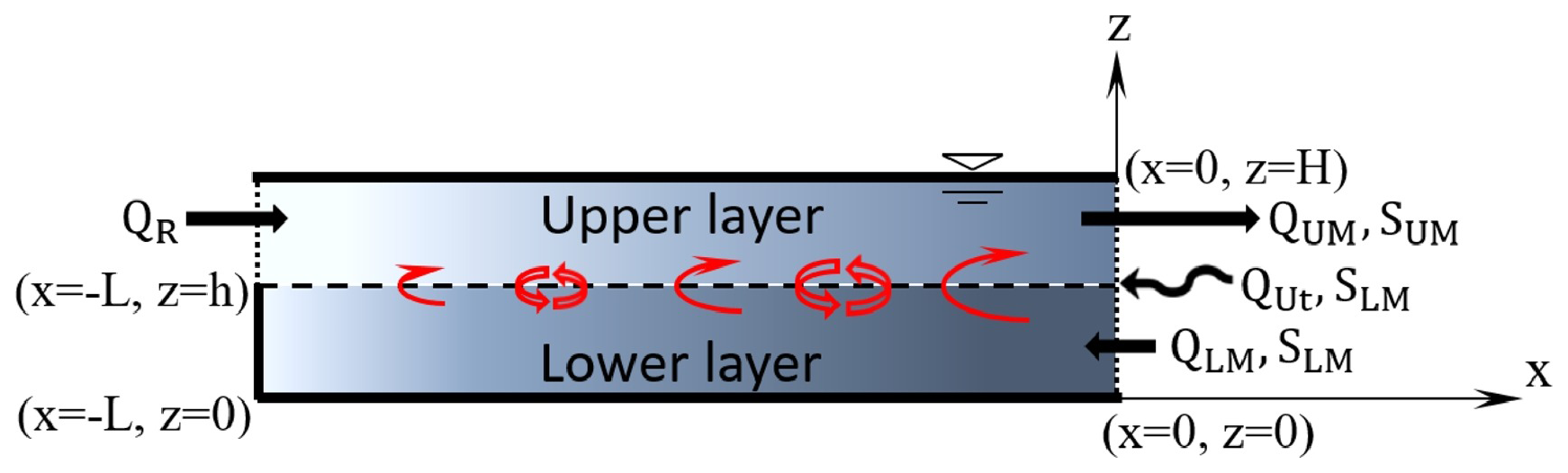
Figure 1Schematic diagram of the estuary box model (EBM) implemented in the Community Earth System Model (CESM) (Sun et al., 2017). The EBM is depicted as a two-layer rectangular box with constant width, uniform local depth (H), and a time-varying length (L). Each layer has a fixed thickness (h for the lower layer and H−h for the upper layer), with vertically uniform but horizontally variable salinity and density. Thick solid lines represent closed boundaries, dotted lines mark open boundaries, and the dashed line shows the interface between layers. Volume fluxes (Q) and salinities (S) are indicated by arrows at open boundaries: riverine freshwater discharge (QR) enters at the estuary head, oceanic saltwater flows into the lower layer at the mouth (QLM), and QUt represents the average tidal volume flux during half a tidal cycle, driving net horizontal salt flux into the upper layer at the mouth. Shear-induced turbulent mixing (shown by paired upward and downward open arrows) and upward advection from exchange flow (solid upward arrows) link the upper and lower layers. The colour gradient illustrates salinity variation, from fresher (lighter shades) to saltier (darker shades) waters. Reprinted from Sun et al. (2017, p. 140), © Elsevier Ltd. (2017), with permission from Elsevier.
New hybrid approaches, such as Hybrid-EBM (Maglietta et al., 2025; Saccotelli et al., 2024), combine physics-based models with machine learning techniques to predict the salt-wedge intrusion length and salinity at river mouths. Hybrid-EBM outperforms the classical EBM and addresses the shortcomings of the dimensional equations in the physics-based EBM, which rely on several tunable coefficients and require site-specific calibration, by substituting them with machine learning algorithms (Maglietta et al., 2025).
2.3 Freshwater input in high-resolution models: unstructured modelling of the river–sea continuum
In contrast, when the model resolution is higher than the estuary width, the latter can be resolved explicitly by extending the grid for some distance inland using either real bathymetry or a straight channel approximation. When extending it beyond the salinity intrusion limit and/or the head of tides, a freshwater flux can be directly specified at the upstream boundary. This is the preferred option in many east coast US studies (Herzfeld, 2015) (e.g. RISE – Liu et al., 2004; LATTE – Choi and Wilkin, 2007; MerMADE – Hetland and MacDonald, 2008).
The use of unstructured grids offers various advantages, including a more accurate treatment of the freshwater inputs from rivers, a realistic representation of river–sea interactions and estuarine processes at spatial and temporal scales usually not resolved in the ocean, and an improved interface between estuaries and the open ocean, sometimes with higher-order spatial discretizations (Staneva et al., 2025, in this report). In addition, the unstructured grid modelling combined with an efficient vertical coordinate system can better resolve the coastal sea dynamics (Verri et al., 2023).
With seamless grid transitions between models or domains, flexibility and cross-scale capabilities are augmented (Zhang et al., 2016). As examples, a river–coastal-ocean continuum model has been developed for the Tiber River delta, reproducing the coastal dynamic processes better than the classic coastal ocean representation, including the salt-wedge intrusion, and revealing new features near the river mouth induced by river discharge and coastal morphology (Bonamano et al., 2024). In the Columbia River estuary, where both shelf and estuarine circulations are coupled, a multi-scale model has proved to be able to reproduce key processes driving the river plume dynamics in a region characterized by complex bathymetry and marked gradients in density and velocity (Vallaeys et al., 2018). Likewise, Vallaeys et al. (2021) used a similar model in a topographically challenging area of the Congo River estuary, characterized by high river discharge, strong stratification, and great depth. Similarly, Maicu et al. (2021) simulated the circulation in the Goro Lagoon and Po River delta branches using downscaling and a seamless chain of models integrating local forcings and dynamics into a coarser OOFS based on a cascading approach.
While these examples were successful in representing dynamical processes across temporal and spatial scales, in some contexts, the large inward tidal extent and/or complex bathymetries and coastlines, often featuring coastal infrastructure, pose significant challenges for explicitly resolving estuaries, making it impractical in many coastal models. As a result, this approach has yet to become standard practice in OOFSs.
2.4 One-way and two-way coupling
Coupling techniques can be used to link two or more models to allow one-way data exchange, for example, between a hydrological model and an ocean model. In this approach, external forcing is reduced to a limited set of variables, simplifying computational requirements but potentially overlooking key processes at the land–sea interface. Additionally, it requires extending the ocean domain boundaries far inland, beyond the limit of tide and storm-surge propagation. While some parameterizations (see Sect. 2.2) or use of unstructured grids (see Sect. 2.3) can partly alleviate these shortcomings, in a compound flooding context, two-way coupled models are preferred because both land and ocean processes can be represented along with their interactions (Bao et al., 2022; Cheng et al., 2010). The inclusion of momentum flux exchanges between land and ocean improves the simulation of estuarine water levels by capturing nonlinear feedbacks between runoff and residual ocean water levels. In a case study of Hurricane Florence, Bao et al. (2022) achieved significant improvement in simulated water levels (20 %–40 % at the head of Cape Fear River estuary) during the post-hurricane period by using a two-way coupled model compared to a stand-alone and linked (one-way coupled) approach.
Alternative approaches for assessing the risk of compound flooding have been proposed, including integrated hydrodynamic and machine learning methods to predict water level dynamics (Sampurno et al., 2022). Such approaches are particularly valuable in data-scarce regions, where developing fully calibrated, computationally intensive models can be impractical or infeasible.
3.1 Freshwater discharge
A persistent challenge in OOFSs with respect to river forcing is the lack of a global network for observed river flows to the oceans. While advances are being made in creating such a network, several challenges remain pertaining to data quality, accessibility, and timeliness at the required spatial and temporal scales.
In situ river discharge observations are necessary to build climatologies. They represent a key component of the calibration of hydrological models and thereby of any reanalysis, near-real-time (NRT) analysis, and forecast products. The various types of discharge products used in OOFSs are described in the following.
3.1.1 Climatologies
Most ocean models use climatologies to introduce river forcing based on multi-decadal averages of observed and/or modelled freshwater discharges, along with zero or constant salinity values. Although climatological data are commonly used, even in cases where estuarine dynamics are not explicitly resolved, more realistic volume flux and salinity estimates would improve the modelling of coastal (e.g. river plumes) to basin-wide circulation and dynamics (e.g. dense water formation, overturning circulation cells, water exchange at straits) (Verri et al., 2018), especially during non-seasonal (e.g. storm-induced) events (Chandanpurkar et al., 2022). Moreover, given the global decline of the hydrometric networks, building climatologies is not always possible, especially for small or less-studied rivers and even for large rivers in regions where routine monitoring is absent (Campuzano et al., 2016; Mishra and Coulibaly, 2009). Furthermore, monthly climatological products are not adequate for high-resolution coastal models where temporal variability at daily or even higher frequency is needed (Sotillo et al., 2021a).
3.1.2 River discharge databases
In contrast, river databases and services are progressively becoming available and provide better estimates of coastal runoff and river discharges at the global scale (Sotillo et al., 2021a). These databases typically assemble information from multiple data providers into coherent, gap-free, and quality-controlled datasets. Examples below are categorized by data source.
In situ databases.
-
The Global Runoff Data Center (https://grdc.bafg.de/, last access: 2 May 2025) (GRDC), under the WMO, archives quality-controlled historical mean daily and monthly discharge data from over 10 000 stations across 159 countries. The Freshwater Fluxes into the World's Oceans (https://fwf.bafg.de/, last access: 2 May 2025) dataset, based on the water balance model WaterGAP, provides annual runoff estimates from 1901–2016.
-
The Global Streamflow Indices and Metadata Archive (GSIM) is a collection of metadata and indices derived from more than 35 000 daily streamflow time series worldwide gathered from 12 open databases (7 national and 5 international collections) (Do et al., 2018; Gudmundsson et al., 2018).
-
A global dataset of monthly streamflow for 925 of the world's largest rivers connecting to the ocean was built by Dai et al. (2009), updated from Dai and Trenberth (2002).
-
A global database of monthly mean runoff for 986 rivers was incorporated in the NCOM, now HYCOM, US model (Barron and Smedstad, 2002). It expands on the work of Perry et al. (1996) with corrections and additions derived from monthly mean streamflow from the U.S. Geological Survey (USGS) (Wahl et al., 1995) and extends the basic RivDIS database (Vörösmarty et al., 1998) to adjust for missing discharge attributed to small (ungauged) rivers.
Model-derived databases.
-
A 35-year daily and monthly global reconstruction of river flows (GRADES) at 2.94 million river reaches, with bias correction from machine-learning-derived global runoff characteristics maps, was developed in support of the Surface Water and Ocean Topography (SWOT) satellite mission (Lin et al., 2019).
-
A dataset of historical river discharge from 1958 to 2016 was created using the CaMa-Flood global river routing model and adjusted runoff from the land component of JRA-55 (Suzuki et al., 2018; Tsujino et al., 2018).
-
A global freshwater budget is included in the CORE.v2 datasets that have an accompanying database for continental runoff from rivers, groundwater, and icebergs. These are estimated from continental imbalances between precipitation, evaporation, and storage and then distributed between bordering ocean basins based on river routing schemes and flow estimates (Large and Yeager, 2009).
Hybrid database.
-
EMODnet Physics (https://emodnet.ec.europa.eu/geoviewer/, last access: 2 May 2025) provides ocean physics data and data products built with common standards, consisting of collections of in situ data, reanalysis, and aggregated in situ data and model outputs. As part of the available parameters, the operational river runoff data include near-real-time data from European river stations and a subset of the GRDC focusing on coastal areas and stations located near river mouths, which extend beyond European borders. About 1200 rivers worldwide are connected and operationally available.
Satellite-derived database.
-
The largest known dataset compiles publicly available river gauge data, with satellite-based rating curves used to fill in the temporal gaps (Riggs et al., 2023).
Regional databases also exist, such as
-
long-term (1993–2011) satellite-derived estimates of continental freshwater discharge into the Bay of Bengal (Papa et al., 2012)
-
a database of pan-Arctic river discharge (R-Arcticnet, https://www.r-arcticnet.sr.unh.edu/v4.0/index.html, last access: 2 May 2025)
-
a database for Greenland liquid water discharge from 1958 through 2019 (Mankoff et al., 2020)
-
a river discharge climatology and corresponding historical time series for all rivers flowing into the Adriatic Sea with an average climatological daily discharge exceeding 1 m3 s−1 (Aragão et al., 2024).
Of particular importance is the fact that some of these databases use model-simulated runoff ratios (e.g. from Community Land Model (CLM) or river routing model) over gauged and ungauged drainage areas to estimate the contribution from the areas not monitored by the hydrometric network and adjust the station flow to represent river mouth outflow (e.g. Dai et al., 2009). This allows more precise derivation of the total discharge into the global oceans through the sum of both gauged and ungauged discharges.
Unless explicitly stated (e.g. for EMODnet Physics), most of these databases lack clearly stated update schedules; some remain static, while others update at irregular intervals. Such databases are useful in the context of a reanalysis but less so in an operational context where near-real-time data feeds are required. Furthermore, a detailed comparative assessment of these various data sources is still lacking.
Alternatively, indirect approaches using tidal statistics at the estuarine entrance from tidal stations rather than direct flow measurements have been developed to estimate the net freshwater discharge at the mouth of an estuary, with the advantage of integrating processes at the basin scale, downstream of the last hydrometric station (Moftakhari et al., 2013, 2016). Because tide gauge records at the coasts were often installed well before the onset of systematic river gauging (Talke and Jay, 2013), such inverse techniques make it possible to extend flow records back in time.
3.1.3 Operational river discharge products
While most river discharge databases are static, operational products have been developed for near-real-time applications. For example, the Global Flood Awareness System, GloFAS-ERA5, is an operational global river discharge reanalysis produced consistently with the ECMWF ERA5 atmospheric reanalysis and providing global gridded data products from 1979 to near-real time (within a 7 d delay) (Harrigan et al., 2020). Figure 2 illustrates the resolution of the river network that emerges in the GloFAS gridded data and the association of discharge at the coast to point sources in a regional model of the northwest Atlantic Ocean that is in development for future operations.
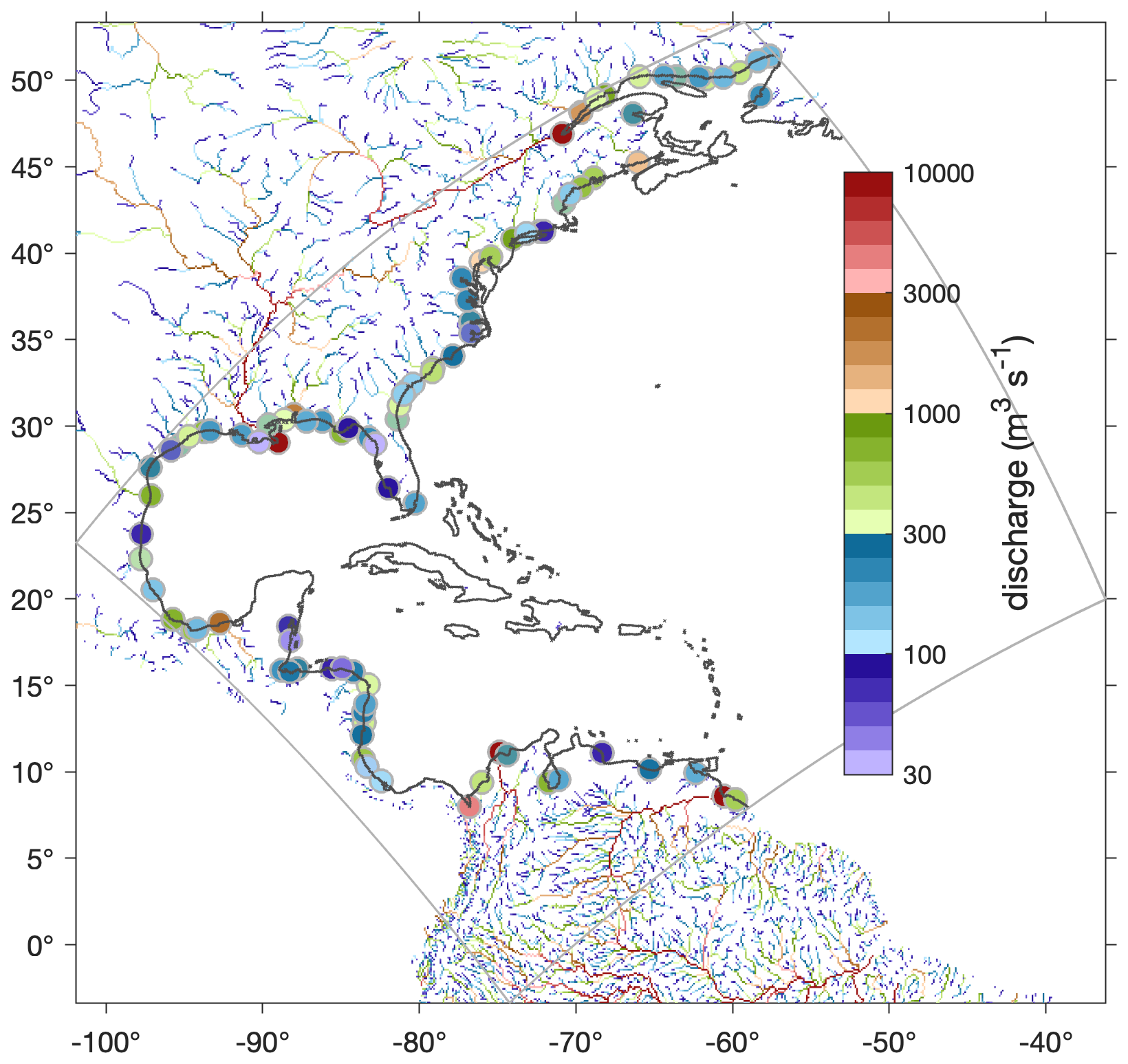
Figure 2Annual mean surface water discharge (m3 s−1) in 0.1° × 0.1° cells of the GloFAS analysis from Harrigan et al. (2020) for the year 2023. Filled circles show the locations of 93 point sources in the prototype East Coast Community Ocean Forecast System (ECCOFS) ROMS model (domain denoted by the gray perimeter box) associated with GloFAS points near the coast that have long-term mean (2009–2019) discharge exceeding 50 m3 s−1. River networks come from GloFAS.
Several centers are also producing continental- and global-scale hydrological (ensemble) forecasts operationally: the European Flood Awareness System (EFAS) (Thielen et al., 2009), the European Hydrological Predictions for the Environment (E-HYPE) (Donnelly et al., 2015), the Hydrologic Ensemble Forecast System (HEPS) in the US (Demargne et al., 2014), the Flood Forecasting and Warning Service (FWWS) in Australia, the National Surface and River Prediction System (NSRPS) in Canada (Fortin et al., 2023), and globally World-Wide HYPE (WWH) (Arheimer et al., 2020) and GloFAS (Harrigan et al., 2023). Notably, as part of the GloFAS service evolution, global daily ensemble river discharge reforecasts (20-year) and real-time forecast (2020–present) datasets are made freely and openly available through the Copernicus Climate Change Service (C3S) Climate Data Store (CDS) (Harrigan et al., 2023).
Other projects have been supported by the Copernicus Marine Environment Monitoring Service (CMEMS): for example, the LAMBDA project regionally focused on the European Atlantic façade and the North Sea. The resulting freshwater model estimates and in situ observations are operationally updated and made available via the project viewer web interface (http://www.cmems-lambda.eu/home.html, last access: 2 May 2025; Sotillo et al., 2021a).
The FOCCUS project (Forecasting and Observing the Open-to-Coastal Ocean for Copernicus Users; https://foccus-project.eu/, last access: 2 May 2025) further enhances operational hydrological models by addressing the land–ocean continuum through improved river runoff estimations and the development of advanced coupling between hydrological and coastal ocean models. FOCCUS builds on existing pan-European hydrological frameworks, such as E-HYPE and LISFLOOD, to provide dynamic freshwater inputs, including nutrient and inorganic matter transport. Additionally, the project integrates novel AI techniques to optimize estuarine modelling and freshwater forcing for coastal systems. These innovations directly contribute to refining CMEMS and supporting all European coastal services with more accurate and seamless coastal monitoring and forecasting capabilities.
In some instances, the regional products may appear to be the preferred option for some regional or local studies, as they were designed to specifically represent the hydrological characteristics of a given region, sometimes with higher resolution and accuracy. However, a global solution is attractive in data-scarce areas and where consistency between discharge products and across all forcing variables is required over large domains (Polton et al., 2023).
3.1.4 Remotely sensed discharges
Remote sensing of river discharge is a rapidly advancing research field (see Gleason and Durand, 2020, and references therein). With the SWOT satellite launched in December 2022, global discharge products will soon be available at a nominal resolution of 10 km for river reaches wider than 100 m, thus vastly expanding measurements of global rivers in both gauged and ungauged basins (Durand et al., 2023). Significant improvements in global uncalibrated models are expected (Emery et al., 2018). SWOT-derived discharge data are expected to improve global hydrological cycle representation and enhance ocean model solutions near the coast.
3.1.5 Machine-learning-derived discharge estimates
Machine learning is increasingly used in hydrology for rainfall runoff modelling, with long short-term memory (LSTM) networks (Greff et al., 2017; Hochreiter and Schmidhuber, 1997) proving particularly effective in capturing both periodic and chaotic patterns in time-series data while accurately learning long-term dependencies (Fang et al., 2017a; Hu et al., 2019; Mouatadid et al., 2019). In numerous hydrological studies, LSTM has demonstrated superior performance over traditional process-based models in simulating runoff, primarily in data-rich regions (Feng et al., 2020, 2021a; Frame et al., 2022; Gauch et al., 2021; Hunt et al., 2022; Konapala et al., 2020; Kratzert et al., 2019; Lees et al., 2021; Li et al., 2023; Luppichini et al., 2024; Nearing et al., 2021; Reichstein et al., 2019). However, limited efforts have explored the transferability of LSTM models to data-scarce regions (e.g. Akpoti et al., 2024), with Ma et al. (2021) and Muhebwa et al. (2024) (and references therein) being examples of such exceptions. Recently, researchers have explored the potential of LSTM models for global river discharge estimations (Rasiya Koya and Roy, 2024; Tang et al., 2023; Yang et al., 2023; Zhao et al., 2021). However, extensive validation beyond the training basins is required to fully evaluate their suitability for global-scale implementations.
3.2 Salinity and temperature
Estuarine mixing influences salinity distribution and its seasonal variability near river mouths (Sun et al., 2019). Models are particularly sensitive to salinity in shelf areas and ROFI zones, most often due to the diverse treatment of OOFSs given to coastal and river freshwater forcing (Sotillo et al., 2021a). Therefore, to assess the impact of a chosen formulation and evaluate model performances, sea surface salinity (SSS) and temperature (SST) are typically used. The World Ocean Atlas climatology (Locarnini et al., 2013; Zweng et al., 2013) often overestimates nearshore salinity, making it unsuitable for model evaluation in coastal regions. As an alternative, Sun et al. (2019) built on the original World Ocean Database and developed an improved salinity and temperature climatology with an enhanced representation of the coastal ocean. In situ data and satellite observations from SMOS, Aquarius, and SMAP (Bao et al., 2019) can also be used to assess the impact of river forcing on sea surface salinity (Feng et al., 2021b). However, seasonal variability in the skill of SSS retrievals can be associated with SST-dependent bias and strong land–sea differences in microwave emissivity, making satellite observations unreliable within some 70 km of the coast (Grodsky et al., 2018; Menezes, 2020; Vazquez-Cuervo et al., 2018). Higher-resolution coastal satellite products have been developed based on empirical relationships between local salinity and ocean colour observations (Geiger et al., 2013; Chen and Hu, 2017), using deep neural networks trained on Sentinel-2 Level-1C top-of-atmosphere (TOA) reflectance data (Medina-Lopez and Ureña-Fuentes, 2019; Medina-Lopez, 2020) or by relating the reflectance of the visible bands from Sentinel-2 imagery with electrical conductivity, influenced by the concentration and composition of dissolved salts (Sakai et al., 2021), although these are not applied globally.
A recent study in the German Bight (Thao et al., 2024) demonstrated the critical role of high-resolution salinity inputs at estuarine mouths in improving the predictive capabilities of coupled wave–ocean models. Using GCOAST (Geesthacht Coupled cOAstal model SysTem), which seamlessly integrates estuarine and coastal dynamics with regional ocean models, researchers validated salinity and temperature fields against in situ observations. The results highlighted that estuarine inflows significantly enhance the accuracy of coastal ocean models.
Alternatively, salinity predictions in estuaries and at river mouths have been successfully estimated using machine learning approaches. A few examples can be found in the recent literature: Qiu and Wan (2013) developed an autoregressive model relating salinity at a given time to past observations of salinity and physical drivers (freshwater inflow, rainfall, tidal elevation) in the Caloosahatchee River estuary; Fang et al. (2017b) used a genetic algorithm coupled with a support vector machine to predict salinity in the Min River estuary; Qi et al. (2022) applied four neural network models to emulate salinity simulations in the Sacramento–San Joaquin Delta from a process-based river, estuary, and land modelling system; Guillou et al. (2023) were able to reproduce the seasonal and semi-diurnal variations in sea surface salinity at the mouth of the Elorn estuary (Bay of Brest), with support vector regression performing best among all tested algorithms.
Despite these advancements, sustained high-resolution salinity monitoring is needed to build confidence in numerical solutions near the coast. Integrating salinity, temperature, and additional parameters such as nutrients and sediments directly into river outflows could further improve model accuracy (Verri et al., 2018; Thao et al., 2024). While these factors play a secondary role in influencing oceanographic processes, their inclusion could advance research on coastal hypoxia, carbon cycling, and regional weather and climate, ultimately supporting seamless predictions of land–ocean–atmosphere feedbacks in next-generation Earth system models (Feng et al., 2021b).
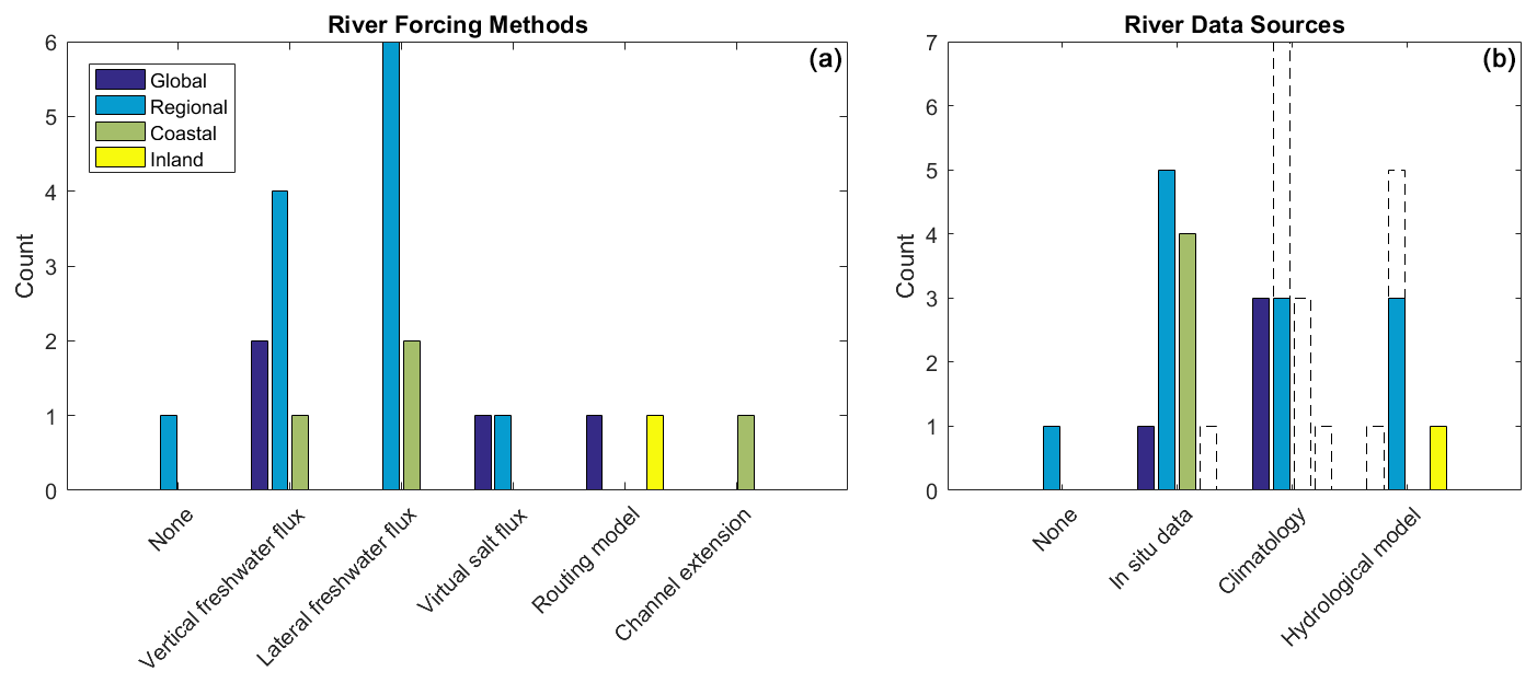
Figure 3Graphical summary from a survey on river forcing methods (a) and data sources (b) used in global, regional, coastal, and inland OOFSs listed in Appendix A. Coloured bars indicate the primary data sources or methods, whereas dashed bars represent secondary data sources used as a fallback when primary sources are unavailable.
This section describes how river forcing is implemented in current OOFSs. The objective is to get a picture of the current landscape of approaches and data sources. While Cirano et al. (2025, in this report) provide a comprehensive overview of existing OOFSs worldwide, the representation of rivers in these systems remains poorly documented and often buried in model configuration files. The list of systems presented in Appendix A is therefore not exhaustive and is limited to a compilation of comments received as part of a survey conducted among members of the OceanPredict community in May 2023. It is meant to illustrate the diversity of methods employed for treating freshwater fluxes in OOFSs and associated input data sources in 4 global, 12 regional, 4 coastal, and 1 inland systems. Although the survey covers a limited number of systems, the literature review in previous sections offers additional examples to complete the picture.
Figure 3 provides a graphical summary of the six river forcing methods and four data sources used in the OOFSs listed in Appendix A. In terms of river forcing methods, most systems specify vertical or lateral freshwater fluxes to account for riverine inputs. Only a few of them rely on more sophisticated approaches that use channel extensions within the ocean model or routing schemes from hydrological models to transport the water from the watershed to the coast. Furthermore, none of the global systems surveyed use lateral boundary conditions, likely due to insufficient spatial resolution near river mouths.
In terms of the data sources used in OOFSs, what stands out from the survey is the use of in situ data as a primary source in most systems and climatology as either a primary or a fallback source of freshwater discharge. Global systems tend to opt for climatologies in comparison with regional or coastal systems that favour observed data when available, which allows both seasonal and non-seasonal events and their potential local or regional impacts to be captured. Only a few regional and inland systems use hydrological models or reanalyses as primary data sources.
Additional considerations were also highlighted by the respondents, essential for appropriately representing river inflow in ocean models and addressing challenges such as numerical instabilities and data limitations. For example, spatial smoothing around the river source or, equivalently, optimizing the integration distance for equivalent coastal precipitation may be required to prevent numerical instabilities. Similarly, an increased diffusivity within the surface mixing layer can be implemented to simulate the effects of river inflow. Salinity and temperature of the input freshwater can be set either to zero and to the local SST, respectively, or derived from a combination of real-time gauge data and monthly averages when available. For ungauged areas, river gauge data can be scaled, or additional coastal runoff can be incorporated. In contrast, some systems directly convert precipitation data into river discharges, disregarding hydrological processes and assuming an instantaneous response.
In sum, the representation of rivers in OOFSs requires careful consideration of various numerical methods, data sources, and modelling approaches. However, some simplifications may limit accuracy in applications requiring high regional precision.
The assessment of river forcing implementation in OOFSs highlights the complexity and challenges of accurately integrating riverine freshwater discharges into ocean models. Despite the growing demand for operational oceanographic products, especially in coastal areas (Ciliberti et al., 2023), OOFS river forcing still faces shortcomings related to the representation of physical processes, data availability, and data quality. The parameterization of river inputs and the interaction between model components, often nonlinear, remain unresolved issues, underscoring the absence of standardized practices for river forcing. Addressing these gaps requires advancements in model physics; improved spatial and temporal resolution; and enhanced coupling between land, ocean, and atmosphere. Furthermore, the incorporation of river flow varies regionally, largely due to differences in the availability and quality of river discharge, salinity, and bathymetric datasets, and is further influenced by model scale and resolution. As the demand for reliable coastal forecasts grows, real-time, high-quality river discharge data become increasingly pressing. Standardized methodologies and improved integration of riverine parameters – including salinity, temperature, and biogeochemical components – will facilitate seamless watershed–ocean coupling and improve predictions of coastal dynamics, particularly under extreme conditions.
Service evolution roadmaps, such as those outlined by CMEMS, emphasize the need for a better characterization of coastal freshwater exchanges to improve forecasts, especially during severe weather events (Sotillo et al., 2021b). A key step forward involves the progressive replacement of static climatologies with real-time, updated time series (past, present, and forecasts) of river inputs, covering both major and minor or ephemeral streams. Recommendations have been made towards standardized freshwater inputs (and associated river inputs of nutrients and sediment loading), harmonized river forcing approaches, and a more integrated watershed–ocean strategy (Campuzano et al., 2016; Capet et al., 2020; Sobrinho et al., 2021). Additionally, ensuring validated observational error estimates for estuary-mouth forcing, including river discharge and auxiliary variables such as coastal salinity, is crucial for model accuracy (De Mey-Frémaux et al., 2019; Polton et al., 2023). Improved interfaces between coastal monitoring and modelling systems are therefore essential. The FOCCUS project exemplifies progress in addressing these challenges through advancements in hydrological and estuarine modelling, dynamic freshwater inputs, and the integration of AI-driven tools to refine river discharge estimations and coastal system forecasts.
Future efforts must focus on refining model physics, resolution, and coupling strategies to better integrate the land–ocean continuum. Standardized methodologies and integrated high-quality data sources, together with continued interdisciplinary collaboration and technological advancements, will be key to overcoming existing limitations and ensuring more accurate and reliable ocean predictions. Such efforts are critical for improving predictions of coastal dynamics and for fostering a deeper understanding of their implications on global climate and ecosystem functioning.
This appendix presents results of a survey conducted among members of the OceanPredict community in May 2023. The responses are reported in the following tables as given by the participants; nearly no changes were made to each contributed entry, except for a few added references and acronym definitions.
A1 Global systems
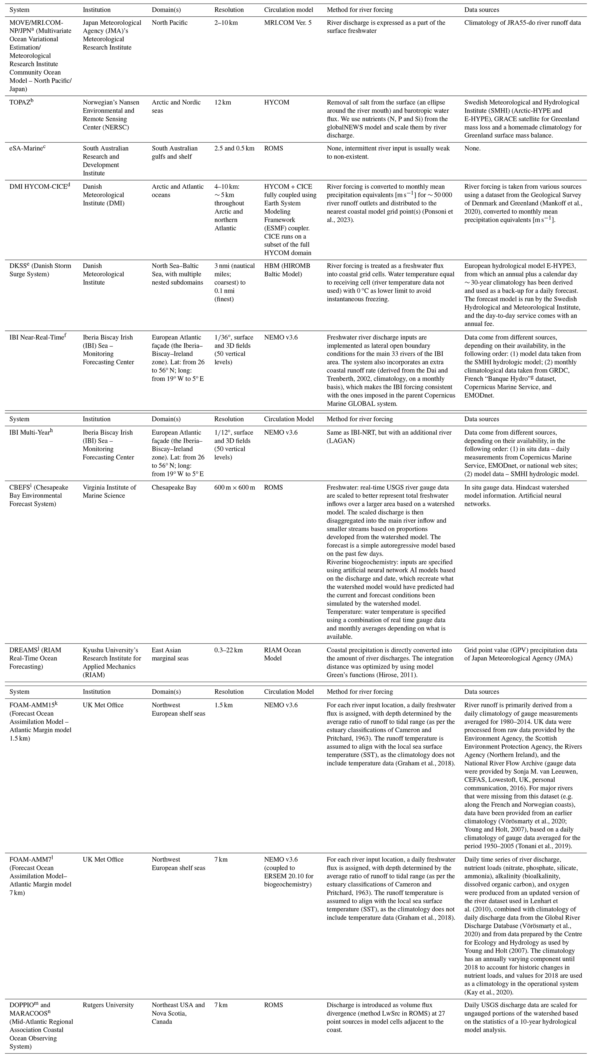
Table A1Examples of river forcing methods and data sources in global OOFSs.
a https://ds.data.jma.go.jp/wmc/products/elnino/move_mricom-g3_doc.html (last access: 2 May 2025). b https://gmao.gsfc.nasa.gov/GEOS_systems/ (last access: 2 May 2025). c https://polar.ncep.noaa.gov/global/about/ (last access: 2 May 2025). d http://www.r-arcticnet.sr.unh.edu/ (last access: 2 May 2025). e https://www.metoffice.gov.uk/services/data/met-office-data-for-reuse/model (last access: 2 May 2025).
A2 Regional systems
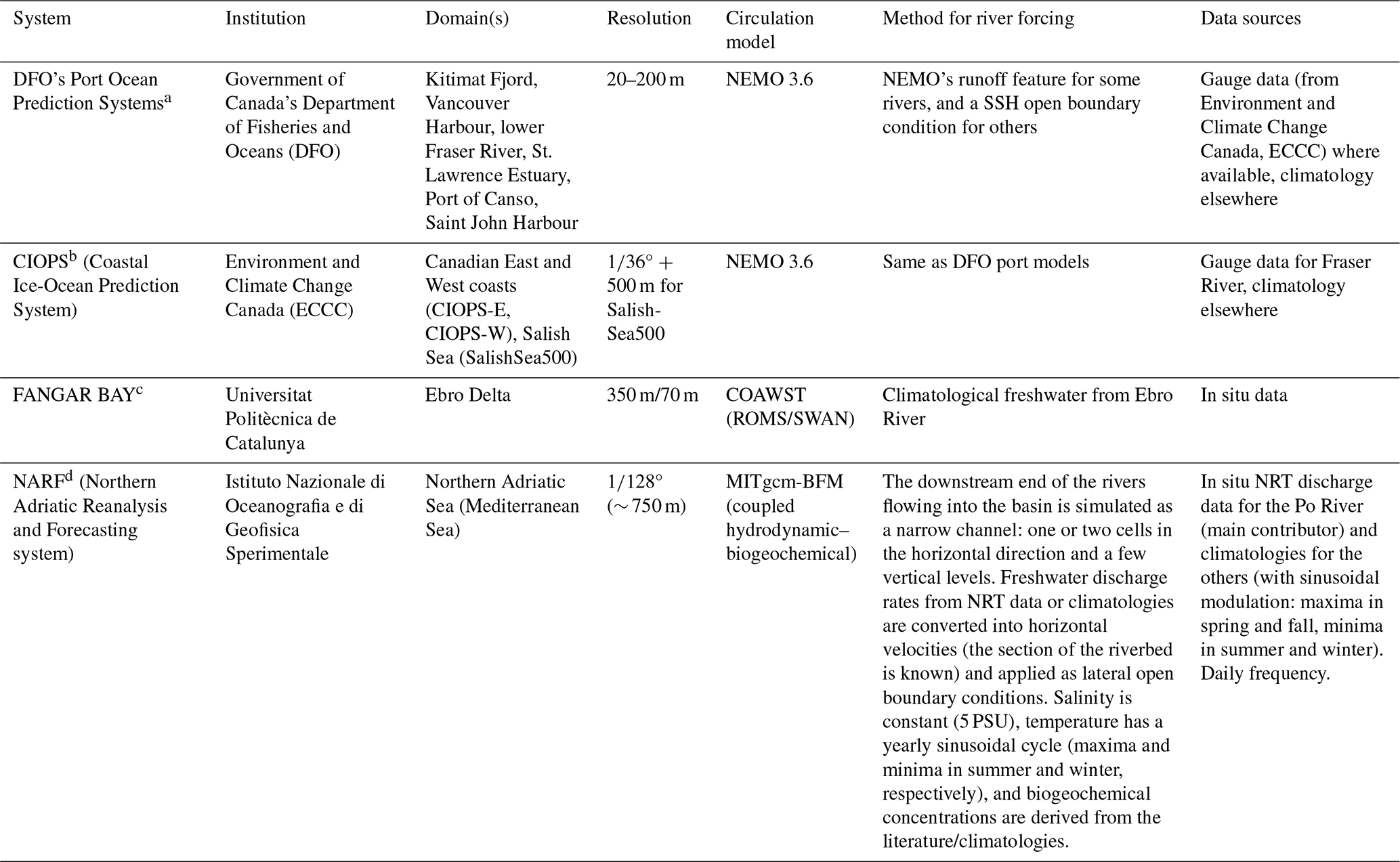
Table A2Examples of river forcing methods and data sources in regional OOFSs.
a https://www.data.jma.go.jp/kaiyou/data/db/kaikyo/knowledge/move_jpn/system.html (last access: 2 May 2025). b https://nersc.no/en/products-and-services/analysis-tools-and-models/ocean-models/ (last access: 2 May 2025). c https://pir.sa.gov.au/research/services/esa_marine/about_esa-marine (last access: 2 May 2025). d https://ocean.dmi.dk/models/hycom.uk.php (last access: 2 May 2025). e https://opendatadocs.dmi.govcloud.dk/Data/Forecast_Data_Storm_Surge_Model_DKSS#:~:text=DKSS%20is%20DMI%27s%20forecast%20model,ice%20thickness%20and%20ice%20concentration (last access: 2 May 2025). f https://marine.copernicus.eu/about/producers/ibi-mfc (last access: 2 May 2025). g http://www.hydro.eaufrance.fr/ (last access: 2 May 2025). h https://marine.copernicus.eu/about/producers/ibi-mfc. i https://www.vims.edu/research/products/cbefs/ (last access: 2 May 2025). j https://dreams-c1.riam.kyushu-u.ac.jp/vwp/ (last access: 2 May 2025). k https://www.metoffice.gov.uk/services/data/met-office-data-for-reuse/model. l https://www.metoffice.gov.uk/services/data/met-office-data-for-reuse/model. m López et al. (2020). n https://maracoos.org/ (last access: 2 May 2025).
A3 Coastal systems
Table A3Examples of river forcing methods and data sources in coastal OOFSs.
a https://publications.gc.ca/site/eng/9.905464/publication.html (last access: 2 May 2025). b https://eccc-msc.github.io/open-data/msc-data/nwp_ciops/readme_ciops_en/ (last access: 2 May 2025). c López et al. (2024). d https://medeaf.ogs.it/got (last access: 2 May 2025).
A4 Inland systems
Table A4Example of river forcing methods and data sources in inland OOFSs.
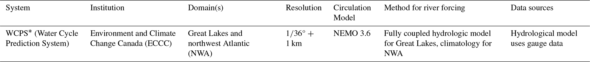
∗ https://eccc-msc.github.io/open-data/msc-data/nwp_wcps/readme_wcps_en/ (last access: 2 May 2025).
No datasets were used in this article.
PM: conceptualization, investigation, writing (original draft preparation), writing (review and editing). JW: writing (review and editing). JS: writing (review and editing).
The contact author has declared that none of the authors has any competing interests.
Publisher's note: Copernicus Publications remains neutral with regard to jurisdictional claims made in the text, published maps, institutional affiliations, or any other geographical representation in this paper. While Copernicus Publications makes every effort to include appropriate place names, the final responsibility lies with the authors.
The authors wish to thank Kristen Wilmer-Becker and members of the OceanPredict community who participated in the survey conducted in May 2023 on the status of the implementation of river forcing in current OOFSs, as well as three anonymous reviewers for their constructive comments on this paper.
This paper was edited by Stefania Angela Ciliberti and reviewed by three anonymous referees.
Akpoti, K., Mekonnen, K., Leh, M., Owusu, A., Dembélé, M., Tinonetsana, P., Seid, A., and Velpuri, N. M.: State of continental discharge estimation and modelling: challenges and opportunities for Africa, Hydrolog. Sci. J., 69, 2124–2152, https://doi.org/10.1080/02626667.2024.2402938, 2024.
Aragão, L., Mentaschi, L., Pinardi, N., Verri, G., Senatore, A., and di Sabatino, S.: The freshwater discharge into the Adriatic Sea revisited, Front. Clim., 6, 1368456, https://doi.org/10.3389/fclim.2024.1368456, 2024.
Arheimer, B., Pimentel, R., Isberg, K., Crochemore, L., Andersson, J. C. M., Hasan, A., and Pineda, L.: Global catchment modelling using World-Wide HYPE (WWH), open data, and stepwise parameter estimation, Hydrol. Earth Syst. Sci., 24, 535–559, https://doi.org/10.5194/hess-24-535-2020, 2020.
Bao, D., Xue, Z. G., Warner, J. C., Moulton, M., Yin, D., Hegermiller, C. A., Zambon, B., and He, R.: A Numerical Investigation of Hurricane Florence-Induced Compound Flooding in the Cape Fear Estuary Using a Dynamically Coupled Hydrological-Ocean Model, J. Adv. Model. Earth Sy., 14, e2022MS003131, https://doi.org/10.1029/2022MS003131, 2022.
Bao, S., Wang, H., Zhang, R., Yan, H., and Chen, J.: Comparison of Satellite-Derived Sea Surface Salinity Products from SMOS, Aquarius, and SMAP, J. Geophys. Res.-Oceans, 124, 1932–1944, https://doi.org/10.1029/2019JC014937, 2019.
Barron, C. N. and Smedstad, L. F.: Global river inflow within the Navy Coastal Ocean Model, OCEANS '02 MTS/IEEE, 29–31 October 2002, Biloxi, MI, USA, 2002, 3, 1472–1479, https://doi.org/10.1109/OCEANS.2002.1191855, 2002.
Blayo, E. and Debreu, L.: Revisiting open boundary conditions from the point of view of characteristic variables, Ocean Model., 9, 231–252, https://doi.org/10.1016/j.ocemod.2004.07.001, 2005.
Blockley, E. W., Martin, M. J., McLaren, A. J., Ryan, A. G., Waters, J., Lea, D. J., Mirouze, I., Peterson, K. A., Sellar, A., and Storkey, D.: Recent development of the Met Office operational ocean forecasting system: an overview and assessment of the new Global FOAM forecasts, Geosci. Model Dev., 7, 2613–2638, https://doi.org/10.5194/gmd-7-2613-2014, 2014.
Bonamano, S., Federico, I., Causio, S., Piermattei, V., Piazzolla, D., Scanu, S., Madonia, A., Madonia, N., de Cillis, G., Jansen, E., Fersini, G., Coppini, G., and Marcelli, M. River–coastal–ocean continuum modeling along the Lazio coast (Tyrrhenian Sea, Italy): Assessment of near river dynamics in the Tiber delta, Estuar. Coast. Shelf S., 297, 108618, https://doi.org/10.1016/j.ecss.2024.108618, 2024.
Bourdallé-Badie, R. and Treguier, A.: A climatology of runoff for the global ocean-ice model ORCA025, Mercator-Ocean report, MOO-RP-425-365-MER, MOO-RP-425-365-MER, 2006.
Cameron, W. M. and Pritchard, D. W.: Estuaries, in: The Sea, vol. 2, edited by: Hill, M. N., John Wiley & Sons, New York, 306–324, 1963.
Campuzano, F., Brito, D., Juliano, M., Fernandes, R., de Pablo, H., and Neves, R.: Coupling watersheds, estuaries and regional ocean through numerical modelling for Western Iberia: a novel methodology, Ocean Dynam., 66, 1745–1756, https://doi.org/10.1007/s10236-016-1005-4, 2016.
Capet, A., Fernández, V., She, J., Dabrowski, T., Umgiesser, G., Staneva, J., Mészáros, L., Campuzano, F., Ursella, L., Nolan, G., and El Serafy, G.: Operational Modeling Capacity in European Seas – An EuroGOOS Perspective and Recommendations for Improvement, Front. Mar. Sci., 7, 1–19, https://doi.org/10.3389/fmars.2020.00129, 2020.
Chandanpurkar, H. A, Lee, T., Wang, X., Zhang, H., Fournier, S., Fenty, I., Fukimori, I., Memnemnlis, D., Piecuc, C. G., Reager, J. T., Wang, O., and Worden, J.: Influence of Nonseasonal River Discharge on Sea Surface Salinity and Height, J. Adv. Model. Earth Sy., 14, e2021MS002715, https://doi.org/10.1029/2021MS002715, 2022.
Chen, S. and Hu, C.: Estimating sea surface salinity in the northern Gulf of Mexico from satellite ocean color measurements, Remote Sens. Environ., 201, 115–132, https://doi.org/10.1016/j.rse.2017.09.004, 2017.
Cheng, H., Cheng, J. C., Hunter, R. M., and Lin, H.: Demonstration of a Coupled Watershed-Nearshore Model, U.S. Army Engineer Research and Development Center, Vicksburg, MS, https://apps.dtic.mil/sti/citations/ADA518953 (last access: 28 July 2024), 2010.
Choi, B.-J. and Wilkin, J. L.: The Effect of Wind on the Dispersal of the Hudson River Plume, J. Phys. Oceanogr., 37, 1878–1897, https://doi.org/10.1175/JPO3081.1, 2007.
Ciliberti, S. A., Alvarez Fanjul, E., Pearlman, J., Wilmer-Becker, K., Bahurel, P., Ardhuin, F., Arnaud, A., Bell, M., Berthou, S., Bertino, L., Capet, A., Chassignet, E., Ciavatta, S., Cirano, M., Clementi, E., Cossarini, G., Coro, G., Corney, S., Davidson, F., Drevillon, M., Drillet, Y., Dussurget, R., El Serafy, G., Fennel, K., Garcia Sotillo, M., Heimbach, P., Hernandez, F., Hogan, P., Hoteit, I., Joseph, S., Josey, S., Le Traon, P.-Y., Libralato, S., Mancini, M., Matte, P., Melet, A., Miyazawa, Y., Moore, A. M., Novellino, A., Porter, A., Regan, H., Romero, L., Schiller, A., Siddorn, J., Staneva, J., Thomas-Courcoux, C., Tonani, M., Garcia-Valdecasas, J. M., Veitch, J., von Schuckmann, K., Wan, L., Wilkin, J., and Zufic, R.: Evaluation of operational ocean forecasting systems from the perspective of the users and the experts, in: 7th edition of the Copernicus Ocean State Report (OSR7), edited by: von Schuckmann, K., Moreira, L., Le Traon, P.-Y., Grégoire, M., Marcos, M., Staneva, J., Brasseur, P., Garric, G., Lionello, P., Karstensen, J., and Neukermans, G., Copernicus Publications, State Planet, 1-osr7, 2, https://doi.org/10.5194/sp-1-osr7-2-2023, 2023.
Cirano, M., Alvarez-Fanjul, E., Capet, A., Ciliberti, S., Clementi, E., Dewitte, B., Dinápoli, M., El Serafy, G., Hogan, P., Joseph, S., Miyazawa, Y., Montes, I., Narvaez, D., Regan, H., Simionato, Smith, G. C., Staneva, J., Tanajura, C. A. S., Thupaki, P., Urbano-Latorre, C., Veitch, J., and Zavala Hidalgo, J.: A description of existing Operational Ocean Forecasting Services around the Globe, in: Ocean prediction: present status and state of the art (OPSR), edited by: Álvarez Fanjul, E., Ciliberti, S. A., Pearlman, J., Wilmer-Becker, K., and Behera, S., Copernicus Publications, State Planet, 5-opsr, 5, https://doi.org/10.5194/sp-5-opsr-5-2025, 2025.
Cossarini, G., Moore, A., Ciavatta, S., and Fennel, K.: Numerical Models for Monitoring and Forecasting Ocean Biogeochemistry: a short description of present status, in: Ocean prediction: present status and state of the art (OPSR), edited by: Álvarez Fanjul, E., Ciliberti, S. A., Pearlman, J., Wilmer-Becker, K., and Behera, S., Copernicus Publications, State Planet, 5-opsr, 12, https://doi.org/10.5194/sp-5-opsr-12-2025, 2025.
Dai, A. and Trenberth, K. E.: Estimates of Freshwater Discharge from Continents: Latitudinal and Seasonal Variations, J. Hydrometeorol., 3, 660–687, https://doi.org/10.1175/1525-7541(2002)003<0660:EOFDFC>2.0.CO;2, 2002.
Dai, A., Qian, T., Trenberth, K. E., and Milliman, J. D.: Changes in Continental Freshwater Discharge from 1948 to 2004, J. Climate, 22, 2773–2792, https://doi.org/10.1175/2008JCLI2592.1, 2009.
Demargne, J., Wu, L., Regonda, S. K., Brown, J. D., Lee, H., He, M., Seo, D.-J., Hartman, R., Herr, H. D., Fresch, M., Schaake, J., and Zhu, Y.: The Science of NOAA's Operational Hydrologic Ensemble Forecast Service, B. Am. Meteorol. Soc., 95, 79–98, https://doi.org/10.1175/BAMS-D-12-00081.1, 2014.
De Mey-Frémaux, P., Ayoub, N., Barth, A., Brewin, R., Charria, G., Campuzano, F., Ciavatta, S., Cirano, M., Edwards, C. A., Federico, I., Gao, S., Garcia Hermosa, I., Garcia Sotillo, M., Hewitt, H., Hole, L. R., Holt, J., King, R., Kourafalou, V., Lu, Y., Mourre, B., Pascual, A., Staneva, J., Stanev, E. V., Wang, H., and Zhu, X.: Model-observations synergy in the coastal ocean, Front. Mar. Sci., 6, 436, https://doi.org/10.3389/fmars.2019.00436, 2019.
Do, H. X., Gudmundsson, L., Leonard, M., and Westra, S.: The Global Streamflow Indices and Metadata Archive (GSIM) – Part 1: The production of a daily streamflow archive and metadata, Earth Syst. Sci. Data, 10, 765–785, https://doi.org/10.5194/essd-10-765-2018, 2018.
Donnelly, C., Andersson, J. C. M., and Arheimer, B.: Using flow signatures and catchment similarities to evaluate the E-HYPE multi-basin model across Europe, Hydrolog. Sci. J., 61, 255–273, https://doi.org/10.1080/02626667.2015.1027710, 2015.
Durand, F., Piecuch, C. G., Becker, M., Papa, F., Raju, S. V., Khan, J. U., and Ponte, R. M.: Impact of Continental Freshwater Runoff on Coastal Sea Level, Surv. Geophys., 40, 1437–1466, https://doi.org/10.1007/s10712-019-09536-w, 2019.
Durand, M., Gleason, C. J., Pavelsky, T. M., Prata de Moraes Frasson, R., Turmon, M., David, C. H., Altenau, E. H., Tebaldi, N., Larnier, K., Monnier, J., Malaterre, P. O., Oubanas, H., Allen, G. H., Astifan, B., Brinkerhoff, C., Bates, P. D., Bjerklie, D., Coss, S., Dudley, R., Fenoglio, L., Garambois, P.-A., Getirana, A., Lin, P., Margulis, S. A., Matte, P., Minear, J. T., Muhebwa, A., Pan, M., Peters, D., Riggs, R., Sikder, M. S., Simmons, T., Stuurman, C., Taneja, J., Tarpanelli, A., Schulze, K., Tourian, M. J., and Wang, J.: A Framework for Estimating Global River Discharge From the Surface Water and Ocean Topography Satellite Mission, Water Resour. Res., 59, e2021WR031614, https://doi.org/10.1029/2021WR031614, 2023.
Dzwonkowski, B., Greer, A. T., Briseño-Avena, C. Krause, J. W., Soto, I. M., Hernandez, F. J., Deary, A. L., Wiggert, J. D., Joung, D., Fitzpatrick, P. J., O'Brien, S. J., Dykstra, S. L., Lau, Y., Cambazoglu, M. K., Lockridge, G., Howden, S. D., Shiller, A. M., and Graham, W. M.: Estuarine influence on biogeochemical properties of the Alabama shelf during the fall season, Cont. Shelf Res., 140, 96–109, https://doi.org/10.1016/j.csr.2017.05.001, 2017.
Emery, C. M., Paris, A., Biancamaria, S., Boone, A., Calmant, S., Garambois, P.-A., and Santos da Silva, J.: Large-scale hydrological model river storage and discharge correction using a satellite altimetry-based discharge product, Hydrol. Earth Syst. Sci., 22, 2135–2162, https://doi.org/10.5194/hess-22-2135-2018, 2018.
Fang, K., Shen, C., Kifer, D., and Yang, X.: Prolongation of SMAP to Spatiotemporally Seamless Coverage of Continental U.S. Using a Deep Learning Neural Network, Geophys. Res. Lett., 44, 11030–11039, https://doi.org/10.1002/2017GL075619, 2017a.
Fang, Y., Chen, X., and Cheng, N.-S.: Estuary salinity prediction using a coupled GA-SVM model: a case study of the Min River Estuary, China, Water Supp., 17, 52–60, https://doi.org/10.2166/ws.2016.097, 2017b.
Feng, D., Fang, K., and Shen, C.: Enhancing streamflow forecast and extracting insights using long-short term memory networks with data integration at continental scales, Water Resour. Res., 56, e2019WR026793, https://doi.org/10.1029/2019WR026793, 2020.
Feng, D., Lawson, K., and Shen, C.: Mitigating Prediction Error of Deep Learning Streamflow Models in Large Data-Sparse Regions With Ensemble Modeling and Soft Data, Geophys. Res. Lett., 48, e2021GL092999, https://doi.org/10.1029/2021GL092999, 2021a.
Feng, Y., Menemenlis, D., Xue, H., Zhang, H., Carroll, D., Du, Y., and Wu, H.: Improved representation of river runoff in Estimating the Circulation and Climate of the Ocean Version 4 (ECCOv4) simulations: implementation, evaluation, and impacts to coastal plume regions, Geosci. Model Dev., 14, 1801–1819, https://doi.org/10.5194/gmd-14-1801-2021, 2021b.
Fortin, V., Innocenti, S., Gaborit, É., Durnford, D., Keita, S., Bruxer, J., Boucher, M.-A., Harrigan, S., Zsoter, E., Dimitrijevic, M., Sévigny, C., O'Brien, N., and Gervasi, N.: Evaluation of continental-scale ensemble hydrological forecasts from Environment and Climate Change Canada: a comparison with forecasts from the Global Flood Awareness System (GloFAS) , EGU General Assembly 2023, Vienna, Austria, 24–28 Apr 2023, EGU23-2950, https://doi.org/10.5194/egusphere-egu23-2950, 2023.
Frame, J. M., Kratzert, F., Klotz, D., Gauch, M., Shalev, G., Gilon, O., Qualls, L. M., Gupta, H. V., and Nearing, G. S.: Deep learning rainfall–runoff predictions of extreme events, Hydrol. Earth Syst. Sci., 26, 3377–3392, https://doi.org/10.5194/hess-26-3377-2022, 2022.
Garvine, R. W.: The impact of model configuration in studies of buoyant coastal discharge, J. Mar. Res., 59, 193–225, https://elischolar.library.yale.edu/journal_of_marine_research/2389 (last access: 2 May 2025), 2001.
Gauch, M., Mai, J., and Lin, J.: The proper care and feeding of CAMELS: How limited training data affects streamflow prediction, Environ. Model. Softw., 135, 104926, https://doi.org/10.1016/j.envsoft.2020.104926, 2021.
Geiger, E. F., Grossi, M. D., Trembanis, A. C., Kohut, J. T., and Oliver, M. J.: Satellite-derived coastal ocean and estuarine salinity in the Mid-Atlantic, Cont. Shelf Res., 63, S235–S242, https://doi.org/10.1016/j.csr.2011.12.001, 2013.
Giffard, P., Llovel, W., Jouanno, J., Morvan, G., and Decharme, B.: Contribution of the Amazon River Discharge to Regional Sea Level in the Tropical Atlantic Ocean, Water, 11, 2348, https://doi.org/10.3390/w11112348, 2019.
Gleason, J. C. and Durand, T. M.: Remote Sensing of River Discharge: A Review and a Framing for the Discipline, Remote Sens., 12, 1107, https://doi.org/10.3390/rs12071107, 2020.
Graham, J. A., O'Dea, E., Holt, J., Polton, J., Hewitt, H. T., Furner, R., Guihou, K., Brereton, A., Arnold, A., Wakelin, S., Castillo Sanchez, J. M., and Mayorga Adame, C. G.: AMM15: a new high-resolution NEMO configuration for operational simulation of the European north-west shelf, Geosci. Model Dev., 11, 681–696, https://doi.org/10.5194/gmd-11-681-2018, 2018.
Greff, K., Srivastava, R. K., Koutník, J., Steunebrink, B. R., and Schmidhuber, J.: LSTM: A Search Space Odyssey, IEEE T. Neur. Net. Lear., 28, 2222–2232, https://doi.org/10.1109/TNNLS.2016.2582924, 2017.
Grodsky, S. A., Vandemark, D., and Feng, H.: Assessing coastal SMAP surface salinity accuracy and its application to monitoring Gulf of Maine circulation dynamics, Remote Sens., 10, 1232, https://doi.org/10.3390/rs10081232, 2018.
Gudmundsson, L., Do, H. X., Leonard, M., and Westra, S.: The Global Streamflow Indices and Metadata Archive (GSIM) – Part 2: Quality control, time-series indices and homogeneity assessment, Earth Syst. Sci. Data, 10, 787–804, https://doi.org/10.5194/essd-10-787-2018, 2018.
Guillou, N., Chapalain, G., and Petton, S.: Predicting sea surface salinity in a tidal estuary with machine learning, Oceanologia, 65, 318–332, https://doi.org/10.1016/j.oceano.2022.07.007, 2023.
Harrigan, S., Zsoter, E., Alfieri, L., Prudhomme, C., Salamon, P., Wetterhall, F., Barnard, C., Cloke, H., and Pappenberger, F.: GloFAS-ERA5 operational global river discharge reanalysis 1979–present, Earth Syst. Sci. Data, 12, 2043–2060, https://doi.org/10.5194/essd-12-2043-2020, 2020.
Harrigan, S., Zsoter, E., Cloke, H., Salamon, P., and Prudhomme, C.: Daily ensemble river discharge reforecasts and real-time forecasts from the operational Global Flood Awareness System, Hydrol. Earth Syst. Sci., 27, 1–19, https://doi.org/10.5194/hess-27-1-2023, 2023.
Herzfeld, M.: Methods for freshwater riverine input into regional ocean models, Ocean Model., 90, 1–15, https://doi.org/10.1016/j.ocemod.2015.04.001, 2015.
Hetland, R. D. and MacDonald, D. G.: Spreading in the near-field Merrimack River plume, Ocean Model., 21, 12–21, https://doi.org/10.1016/j.ocemod.2007.11.001, 2008.
Hirose, N.: Inverse estimation of empirical parameters used in a regional ocean circulation model, J. Oceanogr., 67, 323–336, https://doi.org/10.1007/s10872-011-0041-4, 2011.
Hochreiter, S. and Schmidhuber, J. Long Short-Term Memory, Neural Comput., 9, 1735–1780, https://doi.org/10.1162/neco.1997.9.8.1735, 1997.
Hordoir, R., Polcher, J., Brun-Cottan, J.-C., and Madec, G.: Towards a parametrization of river discharges into ocean general circulation models: a closure through energy conservation, Clim. Dynam., 31, 891–908, https://doi.org/10.1007/s00382-008-0416-4, 2008.
Hu, R., Fang, F., Pain, C. C., and Navon, I. M.: Rapid spatio-temporal flood prediction and uncertainty quantification using a deep learning method, J. Hydrol., 575, 911–920, https://doi.org/10.1016/j.jhydrol.2019.05.087, 2019.
Hunt, K. M. R., Matthews, G. R., Pappenberger, F., and Prudhomme, C.: Using a long short-term memory (LSTM) neural network to boost river streamflow forecasts over the western United States, Hydrol. Earth Syst. Sci., 26, 5449–5472, https://doi.org/10.5194/hess-26-5449-2022, 2022.
Jana, S., Gangopadhyay, A., and Chakraborty, A.: Impact of seasonal river input on the Bay of Bengal simulation, Cont. Shelf Res., 104, 45–62, https://doi.org/10.1016/j.csr.2015.05.001, 2015.
Kay, S., McEwan, R., and Ford, D.: North West European Shelf Production Centre NWSHELF_MULTIYEAR_BIO_004_011, Copernicus Marine Environment Monitoring Service, https://catalogue.marine.copernicus.eu/documents/QUID/CMEMS-NWS-QUID-004-011.pdf (last access: 28 July 2024), 2020.
Konapala, G., Kao, S.-C., Painter, S. L., and Lu, D.: Machine learning assisted hybrid models can improve streamflow simulation in diverse catchments across the conterminous US, Environ. Res. Lett., 15, 104022, https://doi.org/10.1088/1748-9326/aba927, 2020.
Kratzert, F., Klotz, D., Shalev, G., Klambauer, G., Hochreiter, S., and Nearing, G.: Towards learning universal, regional, and local hydrological behaviors via machine learning applied to large-sample datasets, Hydrol. Earth Syst. Sci., 23, 5089–5110, https://doi.org/10.5194/hess-23-5089-2019, 2019.
Lacroix, G., Ruddick, K., Ozer, J., and Lancelot, C.: Modelling the impact of the Scheldt and Rhine/Meuse plumes on the salinity distribution in Belgian waters (southern North Sea), J. Sea Res., 52, 149–163, https://doi.org/10.1016/j.seares.2004.01.003, 2004.
Large, W. G. and Yeager, S. G.: The global climatology of an interannually varying air–sea flux data set, Clim. Dynam., 33, 341–364, https://doi.org/10.1007/s00382-008-0441-3, 2009.
Lees, T., Buechel, M., Anderson, B., Slater, L., Reece, S., Coxon, G., and Dadson, S. J.: Benchmarking data-driven rainfall–runoff models in Great Britain: a comparison of long short-term memory (LSTM)-based models with four lumped conceptual models, Hydrol. Earth Syst. Sci., 25, 5517–5534, https://doi.org/10.5194/hess-25-5517-2021, 2021.
Lenhart, H.-J., Mills, D. K., Baretta-Bekker, H., van Leeuwen, S. M., van der Molen, J., Baretta, J. W., Blaas, M., Desmit, X., Kühn, W., Lacroix, G., Los, H. J., Ménesguen, A., Neves, R., Proctor, R., Ruardij, P., Skogen, M. D., Vanhoutte-Brunier, A., Villars, M. T., and Wakelin, S. L.: Predicting the consequences of nutrient reduction on the eutrophication status of the North Sea, J. Marine Syst., 81, 148–170, https://doi.org/10.1016/j.jmarsys.2009.12.014, 2010.
Li, J., Yuan, X., and Ji, P.: Long-lead daily streamflow forecasting using Long Short-Term Memory model with different predictors, Journal of Hydrology: Regional Studies, 48, 101471, https://doi.org/10.1016/j.ejrh.2023.101471, 2023.
Lin, P., Ming, P., Beck, H. E., Yang, Y., Yamazaki, D., Frasson, R., David, C. H., Durand, M., Pevelsky, T. M., Allen, G. H., Gleason, C. J., and Wood, E. F.: Global Reconstruction of Naturalized River Flows at 2.94 Million Reaches, Water Resour. Res., 55, 6499–6516, https://doi.org/10.1029/2019WR025287, 2019.
Liu, Y., MacCready, P., Hickey, B. M., Dever, E. P., Kosro, P. M., and Banas, N. S.: Evaluation of a coastal ocean circulation model for the Columbia River plume in summer 2004, J. Geophys. Res.-Oceans, 114, C00B04, https://doi.org/10.1029/2008JC004929, 2004.
Locarnini, R. A., Mishonov, A. V., Antonov, J. I., Boyer, T. P., Garcia, H. E., Baranova, O. K., Zweng, M. M., Paver, C. R., Reagan, J. R., Johnson, D. R., Hamilton, M., and Seidov, D.: World Ocean Atlas 2013, Volume 1: Temperature, edited by: Levitus, S. and Mishonov, A., NOAA Atlas NESDIS 73, 40 pp., https://doi.org/10.7289/V55X26VD, 2013.
López, A. G., Wilkin, J. L., and Levin, J. C.: Doppio – a ROMS (v3.6)-based circulation model for the Mid-Atlantic Bight and Gulf of Maine: configuration and comparison to integrated coastal observing network observations, Geosci. Model Dev., 13, 3709–3729, https://doi.org/10.5194/gmd-13-3709-2020, 2020.
López Pérez, T., Balsells Fernández-Pedrera, M., Fernández Tejedor, M., García-Valdecasas, J. M., Grifoll, M., Ballesteros, Ó., Bielsa, E., Mestres, M., García-León, M., Espino, M., and G Sotillo, M.: The e3HOPE service: a high-resolution forecasting system for the hydrodynamics in Fangar Bay (Ebro Delta, NW Mediterranean Sea), EGU General Assembly 2024, Vienna, Austria, 14–19 April 2024, EGU24-11220, https://doi.org/10.5194/egusphere-egu24-11220, 2024.
Luppichini, M., Vailati, G., Fontana, L., and Bini, M.: Machine learning models for river flow forecasting in small catchments, Sci. Rep., 14, 26740, https://doi.org/10.1038/s41598-024-78012-2, 2024.
Ma, K., Feng, D., Lawson, K., Tsai, W.-P., Liang, C., Huang, X., Sharma, A., and Shen, C.: Transferring Hydrologic Data Across Continents – Leveraging Data-Rich Regions to Improve Hydrologic Prediction in Data-Sparse Regions, Water Resour. Res., 57, e2020WR028600, https://doi.org/10.1029/2020WR028600, 2021.
MacCready, P. and Geyer, W. R.: Advances in Estuarine Physics, Annu. Rev. Mar. Sci., 2, 35–58, https://doi.org/10.1146/annurev-marine-120308-081015, 2010.
Maglietta, R., Verri, G., Saccotelli, L., de Lorenzis, A., Cherubini, C., Caccioppoli, R., Dimauro, G., and Coppini, G.: Advancing estuarine box modeling: A novel hybrid machine learning and physics-based approach, Environ. Model. Softw., 183, 106223, https://doi.org/10.1016/j.envsoft.2024.106223, 2025.
Maicu, F., Alessandri, J., Pinardi, N., Verri, G., Umgiesser, G., Lovo, S., Turolla, S., Paccagnella, T., and Valentini, A.: Downscaling With an Unstructured Coastal-Ocean Model to the Goro Lagoon and the Po River Delta Branches, Front. Mar. Sci., 8, 647781, https://doi.org/10.3389/fmars.2021.647781, 2021.
Mankoff, K. D., Noël, B., Fettweis, X., Ahlstrøm, A. P., Colgan, W., Kondo, K., Langley, K., Sugiyama, S., van As, D., and Fausto, R. S.: Greenland liquid water discharge from 1958 through 2019, Earth Syst. Sci. Data, 12, 2811–2841, https://doi.org/10.5194/essd-12-2811-2020, 2020.
Medina-Lopez, E.: Machine learning and the end of atmospheric corrections: A comparison between high-resolution sea surface salinity in coastal areas from top and bottom of atmosphere Sentinel-2 imagery, Remote Sens., 12, 2924, https://doi.org/10.3390/RS12182924, 2020.
Medina-Lopez, E. and Ureña-Fuentes, L.: High-resolution sea surface temperature and salinity in coastal areas worldwide from raw satellite data, Remote Sens., 11, 2191, https://doi.org/10.3390/rs11192191, 2019.
Menezes, V. V.: Statistical assessment of sea-surface salinity from SMAP: Arabian sea, bay of Bengal and a promising red sea application, Remote Sens., 12, 447, https://doi.org/10.3390/rs12030447, 2020.
Milliman J. D. and Farnsworth, K. L.: River Discharge to the Coastal Ocean: A Global Synthesis, Cambridge University Press, Cambridge, https://doi.org/10.1017/CBO9780511781247, 2011.
Mishra, A. K. and Coulibaly, P.: Developments in hydrometric network design: A review, Rev. Geophys., 47, RG2001, https://doi.org/10.1029/2007RG000243, 2009.
Moftakhari, H. R., Jay, D. A., Talke, S. A., Kukulka, T., and Bromirski, P. D.: A novel approach to flow estimation in tidal rivers, Water Resour. Res., 49, 4817–4832, https://doi.org/10.1002/wrcr.20363, 2013.
Moftakhari, H. R., Jay, D. A., and Talke, S. A.: Estimating river discharge using multiple-tide gauges distributed along a channel, J. Geophys. Res.-Oceans, 121, 2078–2097, https://doi.org/10.1002/2015JC010983, 2016.
Mouatadid, S., Adamowski, J. F., Tiwari, M. K., and Quilty, J. M.: Coupling the maximum overlap discrete wavelet transform and long short-term memory networks for irrigation flow forecasting, Agr. Water Manage., 219, 72–85, https://doi.org/10.1016/j.agwat.2019.03.045, 2019.
Muhebwa, A., Gleason, C. J., Feng, D., and Taneja, J.: Improving Discharge Predictions in Ungauged Basins: Harnessing the Power of Disaggregated Data Modeling and Machine Learning, Water Resour. Res., 60, e2024WR037122, https://doi.org/10.1029/2024WR037122, 2024.
Nearing, G. S., Kratzert, F., Sampson, A. K., Pelissier, C. S., Klotz, D., Frame, J. M., Prieto, C., and Gupta, H. V.: What Role Does Hydrological Science Play in the Age of Machine Learning?, Water Resour. Res., 57, e2020WR028091, https://doi.org/10.1029/2020WR028091, 2021.
Papa, F., Bala, S. K., Pandey, R. K., Durand, F., Gopalakrishna, V. v, Rahman, A., and Rossow, W. B.: Ganga-Brahmaputra river discharge from Jason-2 radar altimetry: An update to the long-term satellite-derived estimates of continental freshwater forcing flux into the Bay of Bengal, J. Geophys. Res.-Oceans, 117, C11021, https://doi.org/10.1029/2012JC008158, 2012.
Pein, J. and Staneva, J.: Eutrophication hotspots, nitrogen fluxes and climate impacts in estuarine ecosystems: A model study of the Odra estuary system, Ocean Dynam., 74, 335–354, https://doi.org/10.1007/s10236-024-01607-w, 2024.
Pein, J., Eisele, A., Sanders, T., Daewel, U., Stanev, E. V., van Beusekom, J. E. E., Staneva, J., and Schrum, C.: Seasonal Stratification and Biogeochemical Turnover in the Freshwater Reach of a Partially Mixed Dredged Estuary, Front. Mar. Sci., 8,623714, https://doi.org/10.3389/fmars.2021.623714, 2021.
Perry, G. D., Duffy, P. B., and Miller, N. L.: An extended data set of river discharges for validation of general circulation models, J. Geophys. Res.-Atmos., 10, 21339–21349, https://doi.org/10.1029/96JD00932, 1996.
Piecuch, C. G. and Wadehra, R.: Dynamic Sea Level Variability Due to Seasonal River Discharge: A Preliminary Global Ocean Model Study, Geophys. Res. Lett., 47, e2020GL086984, https://doi.org/10.1029/2020GL086984, 2020.
Piecuch, C. G., Bittermann, K., Kemp, A. C., Ponte, R. M., Little, C. M., Engelhart, S. E., and Lentz, S. J.: River-discharge effects on United States Atlantic and Gulf coast sea-level changes, P. Natl. Acad. Sci. USA, 115, 7729–7734, https://doi.org/10.1073/pnas.1805428115, 2018.
Polton, J., Harle, J., Holt, J., Katavouta, A., Partridge, D., Jardine, J., Wakelin, S., Rulent, J., Wise, A., Hutchinson, K., Byrne, D., Bruciaferri, D., O'Dea, E., De Dominicis, M., Mathiot, P., Coward, A., Yool, A., Palmiéri, J., Lessin, G., Mayorga-Adame, C. G., Le Guennec, V., Arnold, A., and Rousset, C.: Reproducible and relocatable regional ocean modelling: fundamentals and practices, Geosci. Model Dev., 16, 1481–1510, https://doi.org/10.5194/gmd-16-1481-2023, 2023.
Ponsoni, L., Ribergaard, M. H., Nielsen-Englyst, P., Wulf, T., Buus-Hinkler, J., Kreiner, M. B., and Rasmussen, T. A. S.: Greenlandic sea ice products with a focus on an updated operational forecast system, Front. Mar. Sci., 10, 979782, https://doi.org/10.3389/fmars.2023.979782, 2023.
Qi, S., He, M., Bai, Z., Ding, Z., Sandhu, P., Zhou, Y., Namadi, P., Tom, B., Hoang, R., and Anderson, J.: Multi-Location Emulation of a Process-Based Salinity Model Using Machine Learning, Water, 14, 2030, https://doi.org/10.3390/w14132030, 2022.
Qin, T., Fan, J., Zhang, X., Feng, J., Li, C., Dong, B., Wang, K., Zhang, C., Wang, H., Zhang, J., and Yan, D.: Global Freshwater Discharge into the World's Oceans Reached a Record Low Over Past Nearly 70 Years, Research Square, https://doi.org/10.21203/rs.3.rs-1402652/v1, 2022.
Qiu, C. and Wan, Y.: Time series modeling and prediction of salinity in the Caloosahatchee River Estuary, Water Resour. Res., 49, 5804–5816, https://doi.org/10.1002/wrcr.20415, 2013.
Rasiya Koya, S. and Roy, T.: Temporal Fusion Transformers for streamflow Prediction: Value of combining attention with recurrence, J. Hydrol., 637, 131301, https://doi.org/10.1016/j.jhydrol.2024.131301, 2024.
Reichstein, M., Camps-Valls, G., Stevens, B., Jung, M., Denzler, J., Carvalhais, N., and Prabhat: Deep learning and process understanding for data-driven Earth system science, Nature, 566, 195–204, https://doi.org/10.1038/s41586-019-0912-1, 2019.
Rice, A., Whitney, M. M., Garvine, R. W., and Huq, P.: Energetics in Delaware Bay: Comparison of two box models with observations, J. Mar. Res., 66, 873–898, https://elischolar.library.yale.edu/journal_of_marine_research/218 (last access: 5 May 2025), 2008.
Riggs, R. M., Allen, G. H., Wang, J., Pavelsky, T. M., Gleason, C. J., David, C. H., and Durand, M.: Extending global river gauge records using satellite observations, Environ. Res. Lett., 18, 64027, https://doi.org/10.1088/1748-9326/acd407, 2023.
Saccotelli, L., Verri, G., de Lorenzis, A., Cherubini, C., Caccioppoli, R., Coppini, G., and Maglietta, R.: Enhancing estuary salinity prediction: A Machine Learning and Deep Learning based approach, Applied Computing and Geosciences, 23, 100173, https://doi.org/10.1016/j.acags.2024.100173, 2024.
Sakai, T., Omori, K., Oo, A. N., and Zaw, Y. N.: Monitoring saline intrusion in the Ayeyarwady Delta, Myanmar, using data from the Sentinel-2 satellite mission, Paddy Water Environ., 19, 283–294, https://doi.org/10.1007/s10333-020-00837-0, 2021.
Sampurno, J., Vallaeys, V., Ardianto, R., and Hanert, E.: Integrated hydrodynamic and machine learning models for compound flooding prediction in a data-scarce estuarine delta, Nonlin. Processes Geophys., 29, 301–315, https://doi.org/10.5194/npg-29-301-2022, 2022.
Schiller, R. V. and Kourafalou, V. H.: Modeling river plume dynamics with the HYbrid Coordinate Ocean Model, Ocean Model., 33, 101117, https://doi.org/10.1016/j.ocemod.2009.12.005, 2010.
Shi, X., Qin, T., Nie, H., Weng, B., and He, S.: Changes in Major Global River Discharges Directed into the Ocean, Int. J. Env. Res. Pub. He., 16, 1469, https://doi.org/10.3390/ijerph16081469, 2019.
Sobrinho, J., de Pablo, H., Campuzano, F., and Neves, R.: Coupling Rivers and Estuaries with an Ocean Model: An Improved Methodology, Water, 13, 2284, https://doi.org/10.3390/w13162284, 2021.
Sotillo, M. G., Campuzano, F., Guihou, K., Lorente, P., Olmedo, E., Matulka, A., Santos, F., Amo-Baladron, M. A., and Novellino, A.: River Freshwater Contribution in Operational Ocean Models along the European Atlantic Façade: Impact of a New River Discharge Forcing Data on the CMEMS IBI Regional Model Solution, Journal of Marine Science and Engineering, 9, 401, https://doi.org/10.3390/jmse9040401, 2021a.
Sotillo, M. G., Mourre, B., Mestres, M., Lorente, P., Aznar, R., García-León, M., Liste, M., Santana, A., Espino, M., and Álvarez, E.: Evaluation of the Operational CMEMS and Coastal Downstream Ocean Forecasting Services During the Storm Gloria (January 2020), Front. Mar. Sci., 8, 644525, https://doi.org/10.3389/fmars.2021.644525, 2021b.
Sprintall, J. and Tomczak, M.: Evidence of the barrier layer in the surface layer of the tropics, J. Geophys. Res.-Oceans, 97, 7305–7316, https://doi.org/10.1029/92JC00407, 1992.
Staneva, J., Melet, A., Veitch, J., and Matte, P.: Solving Coastal Dynamics: Introduction to High Resolution Ocean Forecasting Services, in: Ocean prediction: present status and state of the art (OPSR), edited by: Álvarez Fanjul, E., Ciliberti, S. A., Pearlman, J., Wilmer-Becker, K., and Behera, S., Copernicus Publications, State Planet, 5-opsr, 4, https://doi.org/10.5194/sp-5-opsr-4-2025, 2025.
Storkey, D., Blaker, A. T., Mathiot, P., Megann, A., Aksenov, Y., Blockley, E. W., Calvert, D., Graham, T., Hewitt, H. T., Hyder, P., Kuhlbrodt, T., Rae, J. G. L., and Sinha, B.: UK Global Ocean GO6 and GO7: a traceable hierarchy of model resolutions, Geosci. Model Dev., 11, 3187–3213, https://doi.org/10.5194/gmd-11-3187-2018, 2018.
Sun, Q., Whitney, M. M., Bryan, F. O., and Tseng, Y.: A box model for representing estuarine physical processes in Earth system models, Ocean Model., 112, 139–153, https://doi.org/10.1016/j.ocemod.2017.03.004, 2017.
Sun, Q., Whitney, M. M., Bryan, F. O., and Tseng, Y.: Assessing the Skill of the Improved Treatment of Riverine Freshwater in the Community Earth System Model (CESM) Relative to a New Salinity Climatology, J. Adv. Model. Earth Sy., 11, 1189–1206, https://doi.org/10.1029/2018MS001349, 2019.
Suzuki, T., Yamazaki, D., Tsujino, H., Komuro, Y., Nakano, H., and Urakawa, S.: A dataset of continental river discharge based on JRA-55 for use in a global ocean circulation model, J. Oceanogr., 74, 421–429, https://doi.org/10.1007/s10872-017-0458-5, 2018.
Talke, S. A. and Jay, D. A.: Nineteenth Century North American and Pacific Tidal Data: Lost or Just Forgotten?, J. Coast. Res., 29, 118–127, https://doi.org/10.2112/JCOASTRES-D-12-00181.1, 2013.
Tang, S., Sun, F., Liu, W., Wang, H., Feng, Y., and Li, Z.: Optimal Postprocessing Strategies With LSTM for Global Streamflow Prediction in Ungauged Basins, Water Resour. Res., 59, e2022WR034352, https://doi.org/10.1029/2022WR034352, 2023.
Thao, N. T., Staneva, J., Grayek, S., Bonaduce, A., Hagemann, S., Nam, T. P., Kumar, R., and Rakovec, O.: Impacts of extreme river discharge on coastal dynamics and environment: Insights from high-resolution modeling in the German Bight, Regional Studies in Marine Science, 73, 103476, https://doi.org/10.1016/j.rsma.2024.103476, 2024.
Thielen, J., Bartholmes, J., Ramos, M.-H., and de Roo, A.: The European Flood Alert System – Part 1: Concept and development, Hydrol. Earth Syst. Sci., 13, 125–140, https://doi.org/10.5194/hess-13-125-2009, 2009.
Tonani, M., Sykes, P., King, R. R., McConnell, N., Péquignet, A.-C., O'Dea, E., Graham, J. A., Polton, J., and Siddorn, J.: The impact of a new high-resolution ocean model on the Met Office North-West European Shelf forecasting system, Ocean Sci., 15, 1133–1158, https://doi.org/10.5194/os-15-1133-2019, 2019.
Tseng, Y., Bryan, F. O., and Whitney, M. M.: Impacts of the representation of riverine freshwater input in the community earth system model, Ocean Model., 105, 71–86, https://doi.org/10.1029/2020MS002276, 2016.
Tsujino, H., Urakawa, S., Nakano, H., Small, R. J., Kim, W. M., Yeager, S. G., Danabasoglu, G., Suzuki, T., Bamber, J. L., Bentsen, M., Böning, C. W., Bozec, A., Chassignet, E. P., Curchitser, E., Boeira Dias, F., Durack, P. J., Griffies, S. M., Harada, Y., Ilicak, M., Josey, S. A., Kobayashi, C., Kobayashi, S., Komuro, Y., Large, W. G., Le Sommer, J., Marsland, S. J., Masina, S., Scheinert, M., Tomita, H., Valdivieso, M., and Yamazaki, D.: JRA-55 based surface dataset for driving ocean–sea-ice models (JRA55-do), Ocean Model., 130, 79–139, https://doi.org/10.1016/j.ocemod.2018.07.002, 2018.
Vallaeys, V., Kärnä, T., Delandmeter, P., Lambrechts, J., Baptista, A. M., Deleersnijder, E., and Hanert, E.: Discontinuous Galerkin modeling of the Columbia River's coupled estuary-plume dynamics, Ocean Model., 124, 111–124, https://doi.org/10.1016/j.ocemod.2018.02.004, 2018.
Vallaeys, V., Lambrechts, J., Delandmeter, P., Pätsch, J., Spitzy, A., Hanert, E., and Deleersnijder, E.: Understanding the circulation in the deep, micro-tidal and strongly stratified Congo River estuary, Ocean Model., 167, 101890, https://doi.org/10.1016/j.ocemod.2021.101890, 2021.
Vazquez-Cuervo, J., Fournier, S., Dzwonkowski, B., and Reager, J.: Intercomparison of In-Situ and Remote Sensing Salinity Products in the Gulf of Mexico, a River-Influenced System, Remote Sens., 10, 1590, https://doi.org/10.3390/rs10101590, 2018.
Verri, G., Pinardi, N., Oddo, P., Ciliberti, S. A., and Coppini, G.: River runoff influences on the Central Mediterranean overturning circulation, Clim. Dynam., 50, 1675–1703, https://doi.org/10.1007/s00382-017-3715-9, 2018.
Verri, G., Pinardi, N., Bryan, F., Tseng, Y., Coppini, G., and Clementi, E.: A box model to represent estuarine dynamics in mesoscale resolution ocean models, Ocean Model., 148, 101587, https://doi.org/10.1016/j.ocemod.2020.101587, 2020.
Verri, G., Mahmoudi Kurdistani, S., Coppini, G., and Valentini, A.: Recent Advances of a Box Model to Represent the Estuarine Dynamics: Time-Variable Estuary Length and Eddy Diffusivity, J. Adv. Model. Earth Sy., 13, e2020MS002276, https://doi.org/10.1029/2020MS002276, 2021.
Verri, G., Barletta, I., Pinardi, N., Federico, I., Alessandri, J., and Coppini, G. Shelf slope, estuarine dynamics and river plumes in a z* vertical coordinate, unstructured grid model, Ocean Model., 184, 102235, https://doi.org/10.1016/j.ocemod.2023.102235, 2023.
Vörösmarty, C. J., Fekete, B. M., and Tucker, B. A.: Discharge compilation from The Global River Discharge (RivDIS) Project. Distributed Active Archive Center, Oak Ridge National Laboratory, PANGAEA [data set], https://doi.org/10.1594/PANGAEA.859439, 1998.
Vörösmarty, C. J., Green, P, Salisbury, J., and Lammers, R. B.: Global Water Resources: Vulnerability from Climate Change and Population Growth, Science, 289, 284–288, https://doi.org/10.1126/science.289.5477.284, 2020.
Wahl, K. L., Thomas, W. O., and Hirsch, R. M.: The stream-gaging program of the U.S. Geological Survey, Circular, 1123, 22 pp. https://doi.org/10.3133/cir1123, 1995.
Yan, D., Li, C., Zhang, X., Wang, J., Feng, J., Dong, B., Fan, J., Wang, K., Zhang, C., Wang, H., Zhang, J., and Qin, T.: A data set of global river networks and corresponding water resources zones divisions, Sci. Data, 9, 770, https://doi.org/10.1038/s41597-022-01888-0, 2022.
Yang, Y., Feng, D., Beck, H. E., Hu, W., Sengupta, A., Monache, L. D., Hartman, R., Lin, P., Shen, C., and Pan, M.: Global Daily Discharge Estimation Based on Grid-Scale Long Short-Term Memory (LSTM) Model and River Routing, ESS Open Archive, https://doi.org/10.22541/essoar.169724927.73813721/v1, 2023.
Yin, J., Stouffer, R. J., Spelman, M. J., and Griffies, S. M.: Evaluating the Uncertainty Induced by the Virtual Salt Flux Assumption in Climate Simulations and Future Projections, J. Climate, 23, 80–96, https://doi.org/10.1175/2009JCLI3084.1, 2010.
Young, E. F. and Holt, J. T.: Prediction and analysis of long-term variability of temperature and salinity in the Irish Sea, J. Geophys. Res.-Oceans, 112, C01008, https://doi.org/10.1029/2005JC003386, 2007.
Zhang, Y. J., Ye, F., Stanev, E. V., and Grashorn, S.: Seamless cross-scale modeling with SCHISM, Ocean Model., 102, 64–81, https://doi.org/10.1016/j.ocemod.2016.05.002, 2016.
Zhao, G., Bates, P., Neal, J., and Pang, B.: Design flood estimation for global river networks based on machine learning models, Hydrol. Earth Syst. Sci., 25, 5981–5999, https://doi.org/10.5194/hess-25-5981-2021, 2021.
Zweng, M. M, Reagan, J. R., Antonov, J. I., Locarnini, R. A., Mishonov, A. V., Boyer, T. P., Garcia, H. E., Baranova, O. K., Johnson, D. R., Seidov, D., and Biddle, M. M.: World Ocean Atlas 2013, Volume 2: Salinity, edited by: Levitus, S. and Mishonov, A., NOAA Atlas NESDIS 74, 39 pp., https://doi.org/10.7289/V5251G4D, 2013.
- Abstract
- Introduction
- River forcing in ocean models
- Data sources
- Examples of current OOFSs
- Summary and recommendations
- Appendix A: Survey on river forcing methods and data sources in current OOFSs
- Data availability
- Author contributions
- Competing interests
- Disclaimer
- Acknowledgements
- Review statement
- References