Articles | Volume 7-osr10
https://doi.org/10.5194/sp-7-osr10-8-2026
© Author(s) 2026. This work is distributed under
the Creative Commons Attribution 4.0 License.
the Creative Commons Attribution 4.0 License.
https://doi.org/10.5194/sp-7-osr10-8-2026
© Author(s) 2026. This work is distributed under
the Creative Commons Attribution 4.0 License.
the Creative Commons Attribution 4.0 License.

30 Sep 2026
| OSR10 | Chapter 2.5
| 30 Sep 2026 | OSR10 | Chapter 2.5
New insights on mesoscale activity in the western Mediterranean Sea
Laura Gómez-Navarro
CORRESPONDING AUTHOR

IMEDEA (UIB-CSIC), Esporles, 07190, Spain
ICM (CSIC), Barcelona, 08003, Spain
Maxime Ballarotta
CLS, Ramonville-Saint-Agne, 31520, France
Diego Cortés-Morales
IMEDEA (UIB-CSIC), Esporles, 07190, Spain
Marie-Isabelle Pujol
CLS, Ramonville-Saint-Agne, 31520, France
Laura Fortunato
Dipartimento di Scienze e tecnologie, Università degli studi di Napoli Parthenope, 80143, Naples, Italy
Baptiste Mourre
IMEDEA (UIB-CSIC), Esporles, 07190, Spain
Ananda Pascual
IMEDEA (UIB-CSIC), Esporles, 07190, Spain
Related authors
Clément Ubelmann, J. Thomas Farrar, Bertrand Chapron, Lucile Gaultier, Laura Gomez-Navarro, Marie-Hélène Rio, and Gérald Dibarboure
Ocean Sci., 21, 2915–2928, https://doi.org/10.5194/os-21-2915-2025, https://doi.org/10.5194/os-21-2915-2025, 2025
Short summary
Short summary
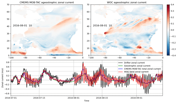
This study models wind-driven ocean currents using observed wind stress and an empirically estimated impulse response function based on drifting buoys. By convolving this function with wind forcing from ERA5, the estimates align well with independent observations across latitudes. Additionally, the response function serves as a valuable indicator of subsurface properties.
Claudio M. Pierard, Siren Rühs, Laura Gómez-Navarro, Michael Charles Denes, Florian Meirer, Thierry Penduff, and Erik van Sebille
Nonlin. Processes Geophys., 32, 411–438, https://doi.org/10.5194/npg-32-411-2025, https://doi.org/10.5194/npg-32-411-2025, 2025
Short summary
Short summary
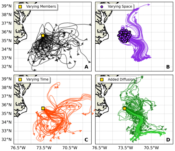
Particle-tracking simulations compute how ocean currents transport material. However, initializing these simulations is often ad hoc. Here, we explore how two different strategies (releasing particles over space or over time) compare. Specifically, we compare the variability in particle trajectories to the variability of particles computed in a 50-member ensemble simulation. We find that releasing the particles over 20 weeks gives variability that is most like that in the ensemble.
Blanca Fernández-Álvarez, Bàrbara Barceló-Llull, and Ananda Pascual
State Planet, 7-osr10, 19, https://doi.org/10.5194/sp-7-osr10-19-2026, https://doi.org/10.5194/sp-7-osr10-19-2026, 2026
Short summary
Short summary
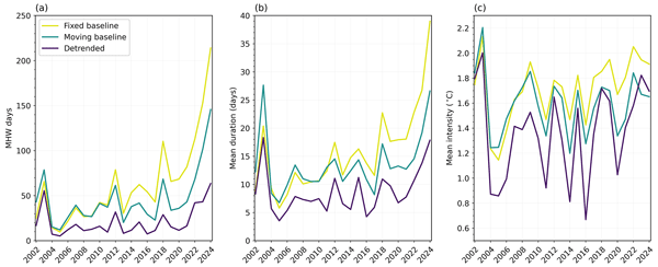
In 2024, the Mediterranean Sea experienced more marine heatwave days than any other year in the past two decades, regardless of the detection method: a fixed baseline (1982–2011), a 20-year moving baseline, or detrended temperature data. The eastern Mediterranean also recorded the highest mean durations across all methods and mean intensities under the fixed baseline. Stating the baseline used is critical in marine heatwave studies, as it affects comparability and interpretation of results.
Juliette Gamot, Antoine Delepoulle, Francesco Nencioli, Marie-Isabelle Pujol, and Gerald Dibarboure
Earth Syst. Sci. Data, 18, 7043–7070, https://doi.org/10.5194/essd-18-7043-2026, https://doi.org/10.5194/essd-18-7043-2026, 2026
Short summary
Short summary
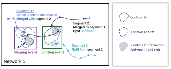
Mesoscale eddies are rotating ocean features that play a key role in transporting heat, salt, and biological material. This study presents a new global dataset derived from satellite observations to track these eddies and identify when they merge or split. By organizing them into interaction networks, we show that such events are frequent and strongly influence eddy evolution, leading to a more realistic description of ocean circulation.
Cristina Martí-Solana, Simón Ruiz, Vincent Combes, Bàrbara Barceló-Llull, Maxime Ballarotta, and Ananda Pascual
State Planet Discuss., https://doi.org/10.5194/sp-2026-11, https://doi.org/10.5194/sp-2026-11, 2026
Preprint under review for SP
Short summary
Short summary
The Southern Ocean helps regulate Earth's climate, and its winds have strengthened for decades, raising the question of whether the current circling Antarctica is speeding up. Using twenty-five years of satellite data, we find little evidence of this. Much of the extra wind energy seems absorbed by small swirling currents, which show signs of intensifying, while current speed and position appear fairly stable. This suggests the ocean may continue absorbing heat and carbon as winds strengthen.
Martina Auditore, Baptiste Mourre, and Paolo Oddo
EGUsphere, https://doi.org/10.5194/egusphere-2026-3276, https://doi.org/10.5194/egusphere-2026-3276, 2026
This preprint is open for discussion and under review for Ocean Science (OS).
Short summary
Short summary
Coastal eddies are rotating water masses that transport heat, nutrients, and other materials, shaping ecosystems and circulation. This study evaluates the new SWOT (Surface Water and Ocean Topography) satellite’s ability to track the alongshore propagation of a coastal eddy in the Algerian Basin (Western Mediterranean). SWOT’s high-resolution daily observations capture eddy evolution in unprecedented detail, revealing interactions with the coast and topography beyond conventional altimetry.
Diego Cortés-Morales, Alban Lazar, Diana Ruiz Pino, and Juliette Mignot
Earth Syst. Sci. Data, 18, 4179–4202, https://doi.org/10.5194/essd-18-4179-2026, https://doi.org/10.5194/essd-18-4179-2026, 2026
Short summary
Short summary
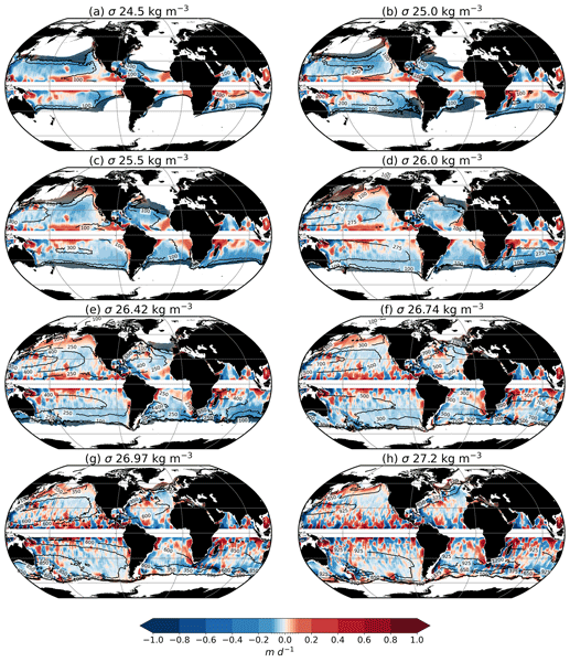
OLIV3 (Observation-based LInear Vorticity Vertical Velocities) is a new global dataset of large-scale oceanic vertical velocities. It is derived from the geostrophic linear vorticity balance, combining in situ and satellite, meridional velocities and wind stress. Comparisons with reanalysis and observation-based products show that OLIV3 captures the large-scale vertical flow, its climatology, and temporal variability, providing a better description of the ocean interior than Ekman pumping.
Manuel Vargas-Yáñez, Orens Pasqueron de Fommervault, Emanuela Clementi, Christian Ferrarin, Svitlana Liubertseva, Diego Álvarez-Berastegui, Baptiste Mourre, Salvatore Aronica, Rosa Balbin, Joaquín Ballabrera-Poy, Sana Ben Ismail, Nathaniel Benssousan, Ismail Bessa, Alicia Blanco, Anthony Bosse, Evi Bourma, François Bourrin, Carlo Brandini, Fulvio Capodici, Clara Casals-Baixas, Branko Cermelj, Giuseppe Ciraolo, Pascal Conan, Laurent Coppola, Lorenzo Corgnati, Joaquín del Río, Emilie Diamond Riquier, Lara Diaz-Barroso, Bartolomeo Doronzo, Xavier Durrieu de Madron, Milad Fakhri, Costantine Frangoulis, Claudia Fratianni, Emilio García-Ladona, Jesus García-Lafuente, M. Carmen García-Martínez, Joaquín Garrabou, Josep Gasol, Adam Gauci, Frédéric Gazeau, Gerard Gregory, Abed El Raman Hassoun, Jordi Isern-Fontanet, Dominique Lefevre, Nadia Lo Bue, Guiomar López, Pablo Lorente, Deny Malengros, Ramon Massana, Sinan Mavruk, Stefano Miserocchi, Behzad Mostajir, Laure Mousseau, Francina Moya, Antonio Novellino, Arianna Orasi, Emanuele Organelli, Vicent Ouisse, Tal Ozer, Begoña Pérez-Gómez, Susana Pérez-Rubio, Leonidas Perivoliotis, Georges Petihakis, Anne Petrenko, Sebastien Pinel, Xavier Pitarch, Angela Pomaro, Lucía Quirós-Collazos, Emma Reyes, Simone Sammartino, Anna Sánchez-Vidal, Katrin Schroeder, Stefano Taddei, Elena Tel, Pierre Testor, Marco Torri, Daniela Turk, Laura Ursella, Dimitris Velaoras, Francesca Vidussi, Ivica Vilivić, Enrico Zambiachi, D. Nikolaos Zarokanellos, George Zodiatis, and Vanessa Cardin
EGUsphere, https://doi.org/10.5194/egusphere-2026-2632, https://doi.org/10.5194/egusphere-2026-2632, 2026
Short summary
Short summary
This work compiles current marine observation capabilities in the Mediterranean Sea, making this information accessible to scientists, organizations, stakeholders, and environmental policymakers. It supports initiatives such as Copernicus Marine Service, EMODNet, the European Ocean Pact, and EU directives. It is intended as a living resource to be updated, identifying strengths and gaps in Mediterranean observation systems.
Mathilde Cancet, Florence Birol, Oscar Vergara, Quentin Dagneaux, Fabien Léger, François Bignalet-Cazalet, Jean-Alexis Daguze, Ergane Fouchet, Alexandre Homerin, Claire Maraldi, Fernando Niño, Marie-Isabelle Pujol, and Ngan Tran
Earth Syst. Sci. Data, 18, 2319–2347, https://doi.org/10.5194/essd-18-2319-2026, https://doi.org/10.5194/essd-18-2319-2026, 2026
Short summary
Short summary
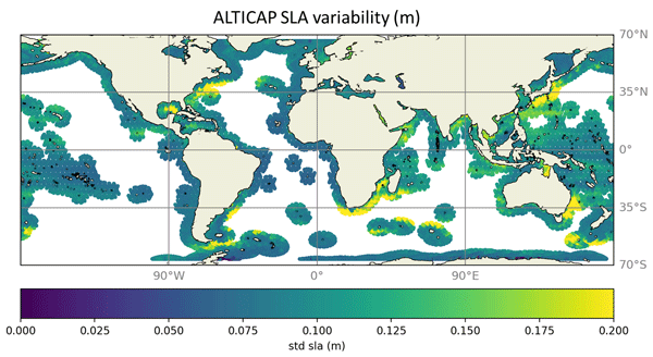
Observing sea level variations at high resolution is paramount for coastal scientific, societal and economic issues. ALTICAP (ALTimetry Innovative Coastal Approach Product) is a new product of Sea Level Anomaly derived from Jason-3 20 Hz along track satellite altimetry and benefiting from the most recent corrections. It covers all coastal ocean up to 500 km from land, from February 2016 to July 2021. It also provides collocated altimetric significant wave height and wind speed.
Chloé Goret, Ariane Koch-Larrouy, Fabius Kouogang, Carina Regina de Macedo, Amine M'Hamdi, Jorge M. Magalhães, José Carlos Bastos da Silva, Michel Tchilibou, Camila Artana, Isabelle Dadou, Antoine Delepoulle, Simon Barbot, Maxime Ballarotta, Loren Carrère, and Alex Costa da Silva
Ocean Sci., 22, 679–698, https://doi.org/10.5194/os-22-679-2026, https://doi.org/10.5194/os-22-679-2026, 2026
Short summary
Short summary
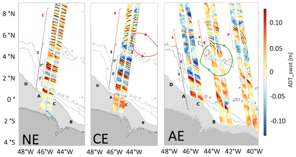
Using high-resolution satellite measurements, we observed how eddies off the Amazon shelf modify internal solitary waves. The results show that these waves can be deflected from their path, even split into two branches, and change their geometry when interacting with different types of eddies. This work provides new insight into the ocean’s complex dynamic interactions and could help guide future predictions of ocean behavior and its effects on coastal and marine ecosystems.

Paul Hargous, Vincent Combes, Bàrbara Barceló-Llull, and Ananda Pascual
Ocean Sci., 22, 549–564, https://doi.org/10.5194/os-22-549-2026, https://doi.org/10.5194/os-22-549-2026, 2026
Short summary
Short summary
Over the last three decades, satellites have revealed rising activity of swirling ocean currents in the Mediterranean Sea. We show that the strength of this increase depends strongly on how satellite data are combined. Products that merge many satellites may give the impression of stronger changes simply because coverage improved over time. This work underlines the importance of using stable and consistent data sets to track long-term changes in ocean variability.
Cécile Kocha, Marine Liévin, Yann Pageot, Clémence Rubin, Victor Quet, Franck Octau, Marie-Isabelle Pujol, Pierre Prandi, Sabine Philipps, Gerald Dibarboure, Isabelino Denis, Carolina Nogueira Loddo, and François Bignalet-Cazalet
Earth Syst. Sci. Data Discuss., https://doi.org/10.5194/essd-2025-604, https://doi.org/10.5194/essd-2025-604, 2026
Revised manuscript under review for ESSD
Short summary
Short summary
30 years of satellite altimetry data were reprocessed in 2024, using state-of-the-art research algorithms and models. The so-called DT-2024 sea level dataset provides a homogenous and consistent set of observations from 15 satellites and 5 climate reference altimeters. This new dataset is shown to improve mesoscale quality and consistency, particularly over coastal and polar areas, as well as the long-term stability for climate research.
Clément Ubelmann, J. Thomas Farrar, Bertrand Chapron, Lucile Gaultier, Laura Gomez-Navarro, Marie-Hélène Rio, and Gérald Dibarboure
Ocean Sci., 21, 2915–2928, https://doi.org/10.5194/os-21-2915-2025, https://doi.org/10.5194/os-21-2915-2025, 2025
Short summary
Short summary
This study models wind-driven ocean currents using observed wind stress and an empirically estimated impulse response function based on drifting buoys. By convolving this function with wind forcing from ERA5, the estimates align well with independent observations across latitudes. Additionally, the response function serves as a valuable indicator of subsurface properties.
Claudio M. Pierard, Siren Rühs, Laura Gómez-Navarro, Michael Charles Denes, Florian Meirer, Thierry Penduff, and Erik van Sebille
Nonlin. Processes Geophys., 32, 411–438, https://doi.org/10.5194/npg-32-411-2025, https://doi.org/10.5194/npg-32-411-2025, 2025
Short summary
Short summary
Particle-tracking simulations compute how ocean currents transport material. However, initializing these simulations is often ad hoc. Here, we explore how two different strategies (releasing particles over space or over time) compare. Specifically, we compare the variability in particle trajectories to the variability of particles computed in a 50-member ensemble simulation. We find that releasing the particles over 20 weeks gives variability that is most like that in the ensemble.
Blanca Fernández-Álvarez, Bàrbara Barceló-Llull, and Ananda Pascual
Ocean Sci., 21, 1987–1999, https://doi.org/10.5194/os-21-1987-2025, https://doi.org/10.5194/os-21-1987-2025, 2025
Short summary
Short summary
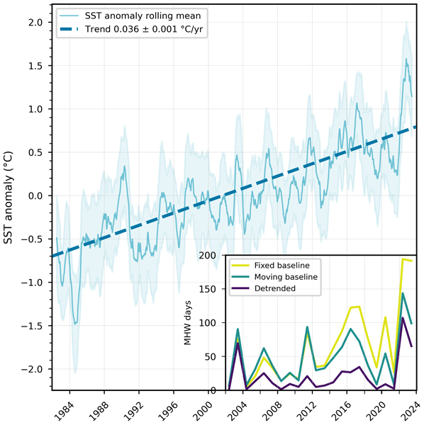
Marine heatwave (MHW) standard detection methods use a fixed baseline, showing rising MHW frequency and intensity due to global warming. To address this, alternative approaches separate long-term warming from extreme events. Here we compare two in the Balearic Sea: a moving baseline and detrended data. From 1982 to 2023, we found a warming trend of 0.036 °C per year, with major MHWs in 2003 and 2022 identified by all methods. Only the fixed baseline shows rising MHW duration and intensity.
Pierre-Yves Le Traon, Gérald Dibarboure, Jean-Michel Lellouche, Marie-Isabelle Pujol, Mounir Benkiran, Marie Drevillon, Yann Drillet, Yannice Faugère, and Elisabeth Remy
Ocean Sci., 21, 1329–1347, https://doi.org/10.5194/os-21-1329-2025, https://doi.org/10.5194/os-21-1329-2025, 2025
Short summary
Short summary
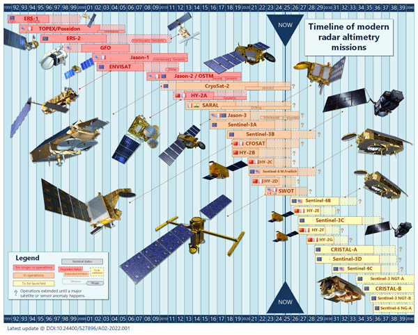
By providing all weather, global, and real-time observations of sea level, a key variable to constrain ocean analysis and forecasting systems, satellite altimetry has had a profound impact on the development of operational oceanography. This paper provides an overview of the development and evolution of satellite altimetry and operational oceanography over the past 20 years from the launch of Jason-1 in 2001 to the launch of SWOT (Surface Water and Ocean Topography) in 2022.
Gerald Dibarboure, Cécile Anadon, Frédéric Briol, Emeline Cadier, Robin Chevrier, Antoine Delepoulle, Yannice Faugère, Alice Laloue, Rosemary Morrow, Nicolas Picot, Pierre Prandi, Marie-Isabelle Pujol, Matthias Raynal, Anaelle Tréboutte, and Clément Ubelmann
Ocean Sci., 21, 283–323, https://doi.org/10.5194/os-21-283-2025, https://doi.org/10.5194/os-21-283-2025, 2025
Short summary
Short summary
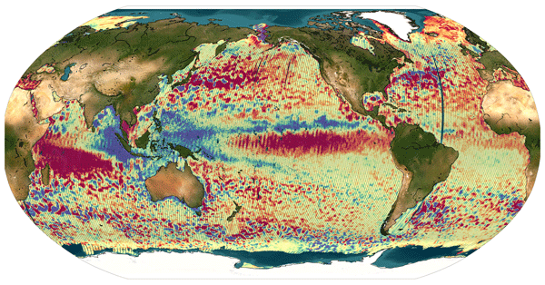
The Surface Water and Ocean Topography (SWOT) mission delivers unprecedented swath-altimetry products. In this paper, we describe how we extended the Level-3 algorithms to handle SWOT’s unique swath-altimeter data. We also illustrate and discuss the benefits, relevance, and limitations of Level-3 swath-altimeter products for various research domains.
Florence Birol, François Bignalet-Cazalet, Mathilde Cancet, Jean-Alexis Daguze, Wassim Fkaier, Ergane Fouchet, Fabien Léger, Claire Maraldi, Fernando Niño, Marie-Isabelle Pujol, and Ngan Tran
Ocean Sci., 21, 133–150, https://doi.org/10.5194/os-21-133-2025, https://doi.org/10.5194/os-21-133-2025, 2025
Short summary
Short summary
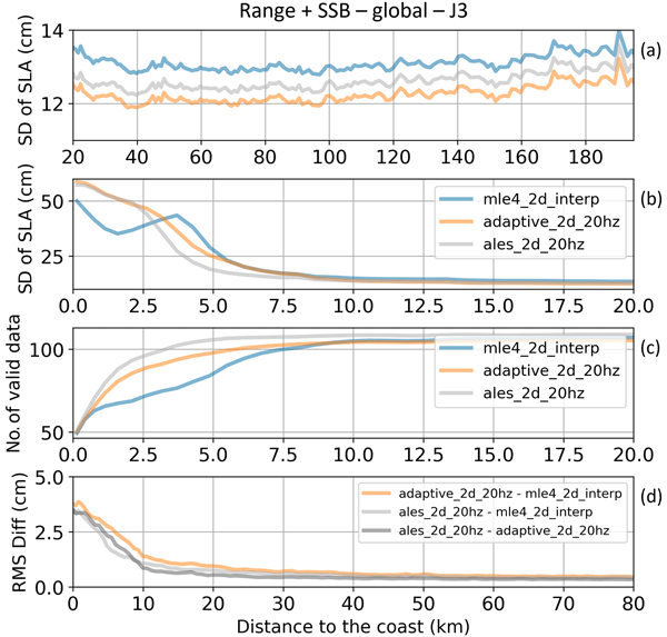
We take advantage of the availability of several algorithms for most of the terms/corrections used to calculate altimetry sea level data to quantify and analyze the sources of uncertainty associated with the approach to the coast. The results highlight their hierarchy. Tidal corrections and mean sea surface height contribute to coastal sea level data uncertainties. Improving the retracking algorithm is today the main factor to bring accurate altimetry sea level data closer to the shore.
Maxime Ballarotta, Clément Ubelmann, Valentin Bellemin-Laponnaz, Florian Le Guillou, Guillaume Meda, Cécile Anadon, Alice Laloue, Antoine Delepoulle, Yannice Faugère, Marie-Isabelle Pujol, Ronan Fablet, and Gérald Dibarboure
Ocean Sci., 21, 63–80, https://doi.org/10.5194/os-21-63-2025, https://doi.org/10.5194/os-21-63-2025, 2025
Short summary
Short summary
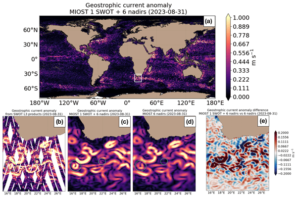
The Surface Water and Ocean Topography (SWOT) mission provides unprecedented swath altimetry data. This study examines SWOT's impact on mapping systems, showing a moderate effect with the current nadir altimetry constellation and a stronger impact with a reduced one. Integrating SWOT with dynamic mapping techniques improves the resolution of satellite-derived products, offering promising solutions for studying and monitoring sea-level variability at finer scales.
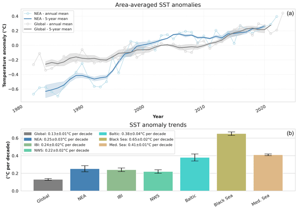
Karina von Schuckmann, Lorena Moreira, Mathilde Cancet, Flora Gues, Emmanuelle Autret, Ali Aydogdu, Lluis Castrillo, Daniele Ciani, Andrea Cipollone, Emanuela Clementi, Gianpiero Cossarini, Alvaro de Pascual-Collar, Vincenzo De Toma, Marion Gehlen, Rianne Giesen, Marie Drevillon, Claudia Fanelli, Kevin Hodges, Simon Jandt-Scheelke, Eric Jansen, Melanie Juza, Ioanna Karagali, Priidik Lagemaa, Vidar Lien, Leonardo Lima, Vladyslav Lyubartsev, Ilja Maljutenko, Simona Masina, Ronan McAdam, Pietro Miraglio, Helen Morrison, Tabea Rebekka Panteleit, Andrea Pisano, Marie-Isabelle Pujol, Urmas Raudsepp, Roshin Raj, Ad Stoffelen, Simon Van Gennip, Pierre Veillard, and Chunxue Yang
State Planet, 4-osr8, 2, https://doi.org/10.5194/sp-4-osr8-2-2024, https://doi.org/10.5194/sp-4-osr8-2-2024, 2024
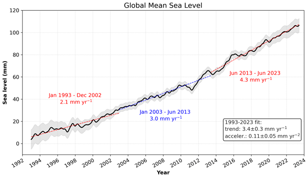
Karina von Schuckmann, Lorena Moreira, Mathilde Cancet, Flora Gues, Emmanuelle Autret, Jonathan Baker, Clément Bricaud, Romain Bourdalle-Badie, Lluis Castrillo, Lijing Cheng, Frederic Chevallier, Daniele Ciani, Alvaro de Pascual-Collar, Vincenzo De Toma, Marie Drevillon, Claudia Fanelli, Gilles Garric, Marion Gehlen, Rianne Giesen, Kevin Hodges, Doroteaciro Iovino, Simon Jandt-Scheelke, Eric Jansen, Melanie Juza, Ioanna Karagali, Thomas Lavergne, Simona Masina, Ronan McAdam, Audrey Minière, Helen Morrison, Tabea Rebekka Panteleit, Andrea Pisano, Marie-Isabelle Pujol, Ad Stoffelen, Sulian Thual, Simon Van Gennip, Pierre Veillard, Chunxue Yang, and Hao Zuo
State Planet, 4-osr8, 1, https://doi.org/10.5194/sp-4-osr8-1-2024, https://doi.org/10.5194/sp-4-osr8-1-2024, 2024
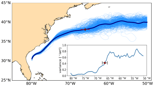
Antonio Sánchez-Román, Flora Gues, Romain Bourdalle-Badie, Marie-Isabelle Pujol, Ananda Pascual, and Marie Drévillon
State Planet, 4-osr8, 4, https://doi.org/10.5194/sp-4-osr8-4-2024, https://doi.org/10.5194/sp-4-osr8-4-2024, 2024
Short summary
Short summary
This study investigates the changing pattern of the Gulf Stream over the last 3 decades as observed in the altimetric record (1993–2022). Changes in the Gulf Stream path have an effect on its speed (and associated energy) and also on waters transported towards the subpolar North Atlantic, impacting Europe's climate. The observed shifts in the paths seem to be linked to variability in the North Atlantic Ocean during winter that may play an important role.
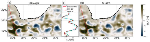
Florian Le Guillou, Lucile Gaultier, Maxime Ballarotta, Sammy Metref, Clément Ubelmann, Emmanuel Cosme, and Marie-Helène Rio
Ocean Sci., 19, 1517–1527, https://doi.org/10.5194/os-19-1517-2023, https://doi.org/10.5194/os-19-1517-2023, 2023
Short summary
Short summary
Altimetry provides sea surface height (SSH) data along one-dimensional tracks. For many applications, the tracks are interpolated in space and time to provide gridded SSH maps. The operational SSH gridded products filter out the small-scale signals measured on the tracks. This paper evaluates the performances of a recently implemented dynamical method to retrieve the small-scale signals from real SSH data. We show a net improvement in the quality of SSH maps when compared to independent data.
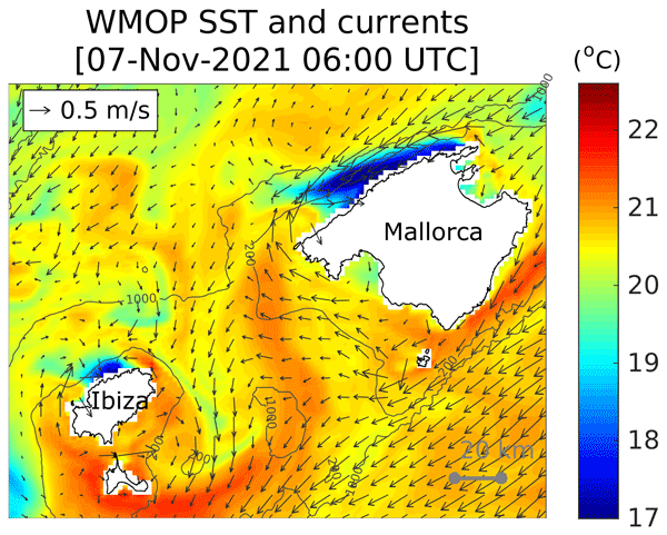
Baptiste Mourre, Emma Reyes, Pablo Lorente, Alex Santana, Jaime Hernández-Lasheras, Ismael Hernández-Carrasco, Maximo García-Jove, and Nikolaos D. Zarokanellos
State Planet, 1-osr7, 15, https://doi.org/10.5194/sp-1-osr7-15-2023, https://doi.org/10.5194/sp-1-osr7-15-2023, 2023
Short summary
Short summary
We characterize the signature of an intense storm-induced coastal upwelling along the north-western coast of the Balearic Islands in 2021 using a high-resolution operational prediction model. The upwelling, with a duration of 3 d and a spatial offshore extension of 20 km, led to cross-shore surface temperature differences of up to 6 °C. It was the most intense event of the past 9 years in terms of the impact on temperature and the second-most intense event in terms of cross-shore transports.
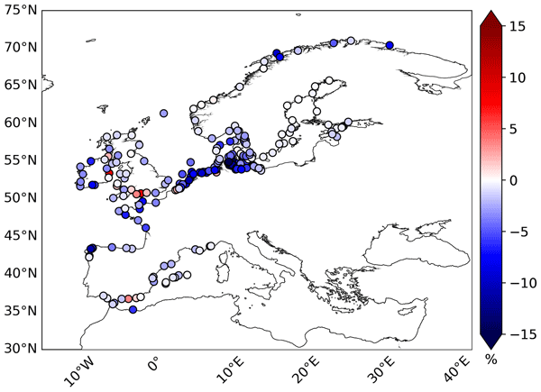
Antonio Sánchez-Román, M. Isabelle Pujol, Yannice Faugère, and Ananda Pascual
Ocean Sci., 19, 793–809, https://doi.org/10.5194/os-19-793-2023, https://doi.org/10.5194/os-19-793-2023, 2023
Short summary
Short summary
This paper assesses the performance of the latest version (DT2021) of global gridded altimetry products distributed through the CMEMS and C3S Copernicus programs on the retrieval of sea level in the coastal zone of the European seas with respect to the previous DT2018 version. This comparison is made using an external independent dataset. DT2021 sea level products better solve the signal in the coastal band.

Oscar Vergara, Rosemary Morrow, Marie-Isabelle Pujol, Gérald Dibarboure, and Clément Ubelmann
Ocean Sci., 19, 363–379, https://doi.org/10.5194/os-19-363-2023, https://doi.org/10.5194/os-19-363-2023, 2023
Short summary
Short summary
Recent advances allow us to observe the ocean from space with increasingly higher detail, challenging our knowledge of the ocean's surface height signature. We use a statistical approach to determine the spatial scale at which the sea surface height signal is no longer dominated by geostrophic turbulence but in turn becomes dominated by wave-type motions. This information helps us to better use the data provided by ocean-observing satellites and to gain knowledge on climate-driving processes.
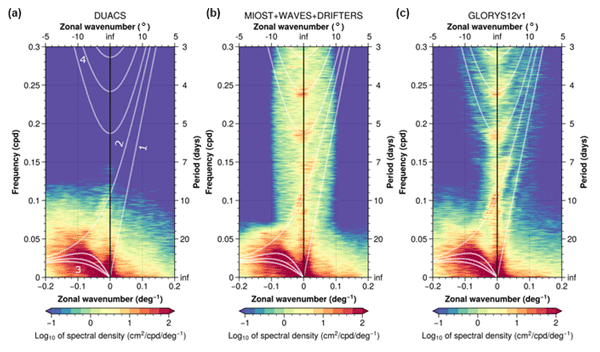
Maxime Ballarotta, Clément Ubelmann, Pierre Veillard, Pierre Prandi, Hélène Etienne, Sandrine Mulet, Yannice Faugère, Gérald Dibarboure, Rosemary Morrow, and Nicolas Picot
Earth Syst. Sci. Data, 15, 295–315, https://doi.org/10.5194/essd-15-295-2023, https://doi.org/10.5194/essd-15-295-2023, 2023
Short summary
Short summary
We present a new gridded sea surface height and current dataset produced by combining observations from nadir altimeters and drifting buoys. This product is based on a multiscale and multivariate mapping approach that offers the possibility to improve the physical content of gridded products by combining the data from various platforms and resolving a broader spectrum of ocean surface dynamic than in the current operational mapping system. A quality assessment of this new product is presented.
Marie-Isabelle Pujol, Stéphanie Dupuy, Oscar Vergara, Antonio Sánchez-Román, Yannice Faugère, Pierre Prandi, Mei-Ling Dabat, Quentin Dagneaux, Marine Lievin, Emeline Cadier, Gérald Dibarboure, and Nicolas Picot
Earth Syst. Sci. Data Discuss., https://doi.org/10.5194/essd-2022-292, https://doi.org/10.5194/essd-2022-292, 2022
Manuscript not accepted for further review
Short summary
Short summary
An altimeter sea level along-track level-3 product with a 5 Hz (~1.2 km) sampling is proposed. It takes advantage of recent advances in radar altimeter processing, and improvements made to different stages of the processing chain. Compared to the conventional 1 Hz (~7 km) product, it significantly improves the observability of the short wavelength signal in open ocean and near coast areas (> 5 km). It also contributes to improving high resolution numerical model outputs via data assimilation.
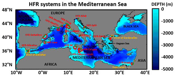
Pablo Lorente, Eva Aguiar, Michele Bendoni, Maristella Berta, Carlo Brandini, Alejandro Cáceres-Euse, Fulvio Capodici, Daniela Cianelli, Giuseppe Ciraolo, Lorenzo Corgnati, Vlado Dadić, Bartolomeo Doronzo, Aldo Drago, Dylan Dumas, Pierpaolo Falco, Maria Fattorini, Adam Gauci, Roberto Gómez, Annalisa Griffa, Charles-Antoine Guérin, Ismael Hernández-Carrasco, Jaime Hernández-Lasheras, Matjaž Ličer, Marcello G. Magaldi, Carlo Mantovani, Hrvoje Mihanović, Anne Molcard, Baptiste Mourre, Alejandro Orfila, Adèle Révelard, Emma Reyes, Jorge Sánchez, Simona Saviano, Roberta Sciascia, Stefano Taddei, Joaquín Tintoré, Yaron Toledo, Laura Ursella, Marco Uttieri, Ivica Vilibić, Enrico Zambianchi, and Vanessa Cardin
Ocean Sci., 18, 761–795, https://doi.org/10.5194/os-18-761-2022, https://doi.org/10.5194/os-18-761-2022, 2022
Short summary
Short summary
High-frequency radar (HFR) is a land-based remote sensing technology that can provide maps of the surface circulation over broad coastal areas, along with wave and wind information. The main goal of this work is to showcase the current status of the Mediterranean HFR network as well as present and future applications of this sensor for societal benefit such as search and rescue operations, safe vessel navigation, tracking of marine pollutants, and the monitoring of extreme events.
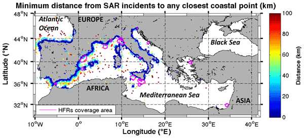
Emma Reyes, Eva Aguiar, Michele Bendoni, Maristella Berta, Carlo Brandini, Alejandro Cáceres-Euse, Fulvio Capodici, Vanessa Cardin, Daniela Cianelli, Giuseppe Ciraolo, Lorenzo Corgnati, Vlado Dadić, Bartolomeo Doronzo, Aldo Drago, Dylan Dumas, Pierpaolo Falco, Maria Fattorini, Maria J. Fernandes, Adam Gauci, Roberto Gómez, Annalisa Griffa, Charles-Antoine Guérin, Ismael Hernández-Carrasco, Jaime Hernández-Lasheras, Matjaž Ličer, Pablo Lorente, Marcello G. Magaldi, Carlo Mantovani, Hrvoje Mihanović, Anne Molcard, Baptiste Mourre, Adèle Révelard, Catalina Reyes-Suárez, Simona Saviano, Roberta Sciascia, Stefano Taddei, Joaquín Tintoré, Yaron Toledo, Marco Uttieri, Ivica Vilibić, Enrico Zambianchi, and Alejandro Orfila
Ocean Sci., 18, 797–837, https://doi.org/10.5194/os-18-797-2022, https://doi.org/10.5194/os-18-797-2022, 2022
Short summary
Short summary
This work reviews the existing advanced and emerging scientific and societal applications using HFR data, developed to address the major challenges identified in Mediterranean coastal waters organized around three main topics: maritime safety, extreme hazards and environmental transport processes. It also includes a discussion and preliminary assessment of the capabilities of existing HFR applications, finally providing a set of recommendations towards setting out future prospects.
Clément Ubelmann, Loren Carrere, Chloé Durand, Gérald Dibarboure, Yannice Faugère, Maxime Ballarotta, Frédéric Briol, and Florent Lyard
Ocean Sci., 18, 469–481, https://doi.org/10.5194/os-18-469-2022, https://doi.org/10.5194/os-18-469-2022, 2022
Short summary
Short summary
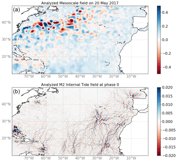
The signature of internal tides has become an important component for high-resolution altimetry over oceans. Several studies have proposed some solutions to resolve part of these internal tides based on the altimetry record. Following these studies, we propose here a new inversion approach aimed to mitigate aliasing with other dynamics. After a description of the methodology, the solution for the main tidal components has been successfully validated against independent observations.

Roxane Tzortzis, Andrea M. Doglioli, Stéphanie Barrillon, Anne A. Petrenko, Francesco d'Ovidio, Lloyd Izard, Melilotus Thyssen, Ananda Pascual, Bàrbara Barceló-Llull, Frédéric Cyr, Marc Tedetti, Nagib Bhairy, Pierre Garreau, Franck Dumas, and Gérald Gregori
Biogeosciences, 18, 6455–6477, https://doi.org/10.5194/bg-18-6455-2021, https://doi.org/10.5194/bg-18-6455-2021, 2021
Short summary
Short summary
This work analyzes an original high-resolution data set collected in the Mediterranean Sea. The major result is the impact of a fine-scale frontal structure on the distribution of phytoplankton groups, in an area of moderate energy with oligotrophic conditions. Our results provide an in situ confirmation of the findings obtained by previous modeling studies and remote sensing about the structuring effect of the fine-scale ocean dynamics on the structure of the phytoplankton community.
Cited articles
20minutos: El GOB denuncia la presencia de numerosos residuos plásticos en aguas del parque Nacional de Cabrera, https://www.20minutos.es/noticia/2517637/0/gob-denuncia-presencia-numerosos-residuos-plasticos-aguas-parque-nacional-cabrera/ (last access: 9 July 2025), 2015.
Aguiar, E., Mourre, B., Alvera-Azcárate, A., Pascual, A., Mason, E., and Tintoré, J.: Strong Long-Lived Anticyclonic Mesoscale Eddies in the Balearic Sea: Formation, Intensification, and Thermal Impact, J. Geophys. Res.-Oceans, 127, e2021JC017589, https://doi.org/10.1029/2021JC017589, 2022.
Archer, M., Wang, J., Klein, P., Dibarboure, G., and Fu, L.-L.: Wide-swath satellite altimetry unveils global submesoscale ocean dynamics, Nature, 640, 691–696, https://doi.org/10.1038/s41586-025-08722-8, 2025.
AVISO/DUACS: SWOT level-3 KaRIn low rate SSH expert (v2.0.1) dataset, CNES [data set], https://doi.org/10.24400/527896/A01-2023.018, 2024.
AVISO/DUACS: SALTO/DUACS Mutlimission Experimental Level-4 maps, computed with SWOT Level-3 products (using both KaRIn and nadir instruments) (v2.0.1), CNES [data set], https://doi.org/10.24400/527896/a01-2025.001, 2025.
Ballarotta, M.: SSALTO/DUACS Experimental Product Handbook: Gridded Sea Level Heights and geostrophic velocities computed with SWOT Level-3 products (using both KaRIn and nadir instruments) with MIOST Version 2.0.1., Issue 2.1, AVISO, https://www.aviso.altimetry.fr/fileadmin/documents/data/tools/hdbk_duacs_experimental_miost_swot_v2.1.pdf (last access: 22 April 2026), 2025.
Ballarotta, M., Ubelmann, C., Pujol, M.-I., Taburet, G., Fournier, F., Legeais, J.-F., Faugère, Y., Delepoulle, A., Chelton, D., Dibarboure, G., and Picot, N.: On the resolutions of ocean altimetry maps, Ocean Sci., 15, 1091–1109, https://doi.org/10.5194/os-15-1091-2019, 2019.
Ballarotta, M., Ubelmann, C., Veillard, P., Prandi, P., Etienne, H., Mulet, S., Faugère, Y., Dibarboure, G., Morrow, R., and Picot, N.: Improved global sea surface height and current maps from remote sensing and in situ observations, Earth Syst. Sci. Data, 15, 295–315, https://doi.org/10.5194/essd-15-295-2023, 2023.
Ballarotta, M., Pujol, M.-I., and SL-TAC team: EU Copernicus Marine Service Quality Information Document for the European Seas Gridded L4 Sea Surface Heights And Derived Variables NRT, SEALEVEL_EUR_PHY_L4_NRT_008_060, Issue 13.0, Mercator Ocean International, https://documentation.marine.copernicus.eu/QUID/CMEMS-SL-QUID-008-032-068.pdf (last access: 16 July 2025), 2025a.
Ballarotta, M., Pujol, M.-I., and SL-TAC team: EU Copernicus Marine Service Quality Information Document for the European Seas Gridded L4 Sea Surface Heights And Derived Variables Reprocessed 1993 Ongoing, SEALEVEL_EUR_PHY_L4_MY_008_068, Issue 13.0, Mercator Ocean International, https://documentation.marine.copernicus.eu/QUID/CMEMS-SL-QUID-008-032-068.pdf (last access: 16 July 2025), 2025b.
Ballarotta, M., Ubelmann, C., Bellemin-Laponnaz, V., Le Guillou, F., Meda, G., Anadon, C., Laloue, A., Delepoulle, A., Faugère, Y., Pujol, M.-I., Fablet, R., and Dibarboure, G.: Integrating wide-swath altimetry data into Level-4 multi-mission maps, Ocean Sci., 21, 63–80, https://doi.org/10.5194/os-21-63-2025, 2025c.
Barceló-Llull, B., Rosselló, P., Combes, V., Sánchez-Román, A., Pujol, M. I., and Pascual, A.: Kuroshio Extension and Gulf Stream dominate the Eddy Kinetic Energy intensification observed in the global ocean, Sci. Rep., 15, https://doi.org/10.1038/s41598-025-06149-9, 2025.
Beron-Vera, F. J., Wang, Y., Olascoaga, M. J., Goni, G. J., and Haller, G.: Objective Detection of Oceanic Eddies and the Agulhas Leakage, J. Phys. Oceanogr., 43, https://doi.org/10.1175/JPO-D-12-0171.1, 2013.
Berthon, J.-F. and Zibordi, G.: Bio-optical relationships for the northern Adriatic Sea, Int. J. Remote Sens., 25, 1527–1532, https://doi.org/10.1080/01431160310001592544, 2004.
Bryden, H. L., Candela, J., and Kinder, T. H.: Exchange through the Strait of Gibraltar, Prog. Oceanogr., 33, 201–248, https://doi.org/10.1016/0079-6611(94)90028-0, 1994.
Coadou-Chaventon, S., Swart, S., Novelli, G., and Speich, S.: Resolving Sharper Fronts of the Agulhas Current Retroflection Using SWOT Altimetry, Geophys. Res. Lett., 52, https://doi.org/10.1029/2025gl115203, 2025.
Compa, M., Alomar, C., Mourre, B., March, D., Tintoré, J., and Deudero, S.: Nearshore spatio-temporal sea surface trawls of plastic debris in the Balearic Islands, Mar. Environ. Res., 158, 104945, https://doi.org/10.1016/j.marenvres.2020.104945, 2020.
Cotroneo, Y., Celentano, P., Aulicino, G., Perilli, A., Olita, A., Falco, P., Sorgente, R., Ribotti, A., Budillon, G., Fusco, G., and Pessini, F.: Connectivity Analysis Applied to Mesoscale Eddies in the Western Mediterranean Basin, Remote Sensing, 13, 4228, https://doi.org/10.3390/rs13214228, 2021.
Cui, A., Zhang, Z., Yan, H., and Han, B.: Spatial and Temporal Characteristics of Mesoscale Eddies in the North Atlantic Ocean Based on SWOT Mission, Remote Sens., 17, 1469, https://doi.org/10.3390/rs17081469, 2025.
Delandmeter, P. and van Sebille, E.: The Parcels v2.0 Lagrangian framework: new field interpolation schemes, Geosci. Model Dev., 12, 3571–3584, https://doi.org/10.5194/gmd-12-3571-2019, 2019.
Delepoulle, A., Mason, E., Busché, C., Pegliasco, C., Capet, A., Troupin, C., and Koldunov, N.: AntSimi/pyeddy-tracker: v3.6.1, Zenodo [code], https://doi.org/10.5281/zenodo.6333988, 2022.
de Marez, C., Bendinger, A., and Dilmahamod, A. F.: High-latitude eddy statistics from SWOT compared with in situ observations, Ocean Sci., 22, 1515–1528, https://doi.org/10.5194/os-22-1515-2026, 2026.
Diario de Mallorca: Casi la totalidad de los residuos de Cabrera son plásticos, https://www.diariodemallorca.es/mallorca/2022/04/18/totalidad-residuos-cabrera-son-plasticos-65095274.html (last access: 9 July 2025), 2022.
Dibarboure, G., Anadon, C., Briol, F., Cadier, E., Chevrier, R., Delepoulle, A., Faugère, Y., Laloue, A., Morrow, R., Picot, N., Prandi, P., Pujol, M.-I., Raynal, M., Tréboutte, A., and Ubelmann, C.: Blending 2D topography images from the Surface Water and Ocean Topography (SWOT) mission into the altimeter constellation with the Level-3 multi-mission Data Unification and Altimeter Combination System (DUACS), Ocean Sci., 21, 283–323, https://doi.org/10.5194/os-21-283-2025, 2025.
Escudier, R., Mourre, B., Juza, M., and Tintoré, J.: Subsurface circulation and mesoscale variability in the Algerian subbasin from altimeter-derived eddy trajectories, J. Geophys. Res.-Oceans, 121, 6310–6322, https://doi.org/10.1002/2016JC011760, 2016.
E.U. Copernicus Marine Service Information (CMEMS): Mediterranean Sea, Bio-Geo-Chemical, L3, daily Satellite Observations (1997–ongoing), Marine Data Store (MDS) [data set], https://doi.org/10.48670/moi-00299, 2023.
EU Copernicus Marine Service Product: Mediterranean Sea Mean Dynamic Topography, Mercator Ocean International [data set], https://doi.org/10.48670/moi-00151, 2024.
EU Copernicus Marine Service Product: European Seas Gridded L4 Sea Surface Heights And Derived Variables NRT, Mercator Ocean International [data set], https://doi.org/10.48670/moi-00142, 2025a.
EU Copernicus Marine Service Product: European Seas Gridded L4 Sea Surface Heights And Derived Variables Reprocessed 1993 Ongoing, Mercator Ocean International [data set], https://doi.org/10.48670/moi-00141, 2025b.
Fablet, R., Beauchamp, M., Drumetz, L., and Rousseau, F.: Joint Interpolation and Representation Learning for Irregularly Sampled Satellite-Derived Geophysical Fields, Front. Appl. Math. Stat., 7, 655224, https://doi.org/10.3389/fams.2021.655224, 2021.
Fortunato, L., Gómez-Navarro, L., Combes, V., Cotroneo, Y., Aulicino, G., and Pascual, A.: Coastal Eddy Detection in the Balearic Sea: SWOT Capabilities, Remote Sens., 17, 2552, https://doi.org/10.3390/rs17152552, 2025.
Fu, C., Han, X., Wang, Q., Pennelly, C., and Myers, P. G.: Wide-swath satellite altimetry reveals hotspots of small mesoscale eddies in the western Arctic Ocean, Commun. Earth Environ., 7, 344, https://doi.org/10.1038/s43247-026-03498-9, 2026.
Fu, L., Pavelsky, T., Cretaux, J., Morrow, R., Farrar, J. T., Vaze, P., Sengenes, P., Vinogradova-Shiffer, N., Sylvestre-Baron, A., Picot, N., and Dibarboure, G.: The Surface Water and Ocean Topography Mission: A Breakthrough in Radar Remote Sensing of the Ocean and Land Surface Water, Geophys. Res. Lett., 51, e2023GL107652, https://doi.org/10.1029/2023GL107652, 2024.
Gómez-Navarro, L.: LauraGomezNavarro/paper-OSR10_Gomez-Navarro_etal_2026: First release update (Version v1.0.2), Zenodo [code], https://doi.org/10.5281/zenodo.22725565, 2026.
Haller, G., Hadjighasem, A., Farazmand, M., and Huhn, F.: Defining coherent vortices objectively from the vorticity, J. Fluid Mech., 795, 136–173, https://doi.org/10.1017/jfm.2016.151, 2016.
Han, X., Wang, Q., Stewart, A. L., Wang, Z., Yang, Q., Ni, Q., Liu, C., and Chen, D.: High coastal eddy activity around Antarctica revealed by SWOT, Natl. Sci. Rev., 13, nwag181, https://doi.org/10.1093/nsr/nwag181, 2026.
Hargous, P., Combes, V., Barceló-Llull, B., and Pascual, A.: Eddy kinetic energy variability from 30 years of altimetry in the Mediterranean Sea, Ocean Sci., 22, 549–564, https://doi.org/10.5194/os-22-549-2026, 2026.
Hogg, A. M., Meredith, M. P., Chambers, D. P., Abrahamsen, E. P., Hughes, C. W., and Morrison, A. K.: Recent trends in the Southern Ocean eddy field, J. Geophys. Res.-Oceans, 120, 257–267, https://doi.org/10.1002/2014JC010470, 2015.
Ioannou, A., Guez, L., Laxenaire, R., and Speich, S.: Global Assessment of Mesoscale Eddies with TOEddies: Comparison Between Multiple Datasets and Colocation with In Situ Measurements, Remote Sens., 16, 4336, https://doi.org/10.3390/rs16224336, 2024.
Kurian, J., Colas, F., Capet, X., McWilliams, J. C., and Chelton, D. B.: Eddy properties in the California Current System, J. Geophys. Res., 116, C08027, https://doi.org/10.1029/2010JC006895, 2011.
Le Guillou, F., Gaultier, L., Ballarotta, M., Metref, S., Ubelmann, C., Cosme, E., and Rio, M.-H.: Regional mapping of energetic short mesoscale ocean dynamics from altimetry: performances from real observations, Ocean Sci., 19, 1517–1527, https://doi.org/10.5194/os-19-1517-2023, 2023.
Le Guillou, F., Chapron, B., and Rio, M.: VarDyn: Dynamical Joint‐Reconstructions of Sea Surface Height and Temperature From Multi‐Sensor Satellite Observations, J. Adv. Model. Earth Sy., 17, e2024MS004689, https://doi.org/10.1029/2024MS004689, 2025.
Le Traon, P. Y., Nadal, F., and Ducet, N.: An Improved Mapping Method of Multisatellite Altimeter Data, J. Atmos. Ocean. Tech., 15, 522–534, https://doi.org/10.1175/1520-0426(1998)015<0522:AIMMOM>2.0.CO;2, 1998.
Lopez-Radcenco, M., Pascual, A., Gómez-Navarro, L., Aissa-El-Bey, A., Chapron, B., and Fablet, R.: Analog Data Assimilation of Along-Track Nadir and Wide-Swath SWOT Altimetry Observations in the Western Mediterranean Sea, IEEE J. Sel. Top. Appl., 12, 2530–2540, https://doi.org/10.1109/JSTARS.2019.2903941, 2019.
Liu, T., Abernathey, R., Sinha, A., and Chen, D.: Quantifying Eulerian Eddy Leakiness in an Idealized Model, J. Geophys. Res.-Oceans, 124, 8869–8886, https://doi.org/10.1029/2019JC015576, 2019.
Marcos, M., Pascual, A., and Pujol, I.: Improved satellite altime- ter mapped sea level anomalies in the Mediterranean Sea: A comparison with tide gauges, Adv. Space Res., 56, 596–604, https://doi.org/10.1016/j.asr.2015.04.027, 2015.
Martínez-Moreno, J., Hogg, A. M., Kiss, A. E., Constantinou, N. C., and Morrison, A. K.: Kinetic Energy of Eddy-Like Features From Sea Surface Altimetry, J. Adv. Model. Earth Sy., 11, 3090–3105, https://doi.org/10.1029/2019MS001769, 2019.
Mason, E., Pascual, A., and McWilliams, J. C.: A New Sea Surface Height–Based Code for Oceanic Mesoscale Eddy Tracking, J. Atmos. Ocean. Tech., 31, 1181–1188, https://doi.org/10.1175/JTECH-D-14-00019.1, 2014.
Mason, E., Ruiz, S., Bourdalle-Badie, R., Reffray, G., García-Sotillo, M., and Pascual, A.: New insight into 3-D mesoscale eddy properties from CMEMS operational models in the western Mediterranean, Ocean Sci., 15, 1111–1131, https://doi.org/10.5194/os-15-1111-2019, 2019.
Morrow, R., Fu, L.-L., Ardhuin, F., Benkiran, M., Chapron, B., Cosme, E., d'Ovidio, F., Farrar, J. T., Gille, S. T., Lapeyre, G., Le Traon, P.-Y., Pascual, A., Ponte, A., Qiu, B., Rascle, N., Ubelmann, C., Wang, J., and Zaron, E. D.: Global Observations of Fine-Scale Ocean Surface Topography With the Surface Water and Ocean Topography (SWOT) Mission, Front. Mar. Sci., 6, 232, https://doi.org/10.3389/fmars.2019.00232, 2019.
Pascual, A., Pujol, M.-I., Larnicol, G., Le Traon, P.-Y., and Rio, M.-H.: Mesoscale mapping capabilities of multisatellite altimeter missions: First results with real data in the Mediterranean Sea, J. Mar. Syst., 211, 65, https://doi.org/10.1016/j.jmarsys.2004.12.004, 2007.
Pascual, A., Boone, C., Larnicol, G., and Le Traon, P.-Y.: On the Quality of Real-Time Altimeter Gridded Fields: Comparison with In Situ Data, J. Atmos. Ocean. Tech., 26, 556–569, https://doi.org/10.1175/2008jtecho556.1, 2009.
Pegliasco, C., Chaigneau, A., Morrow, R., and Dumas, F.: Detection and tracking of mesoscale eddies in the Mediterranean Sea: A comparison between the Sea Level Anomaly and the Absolute Dynamic Topography fields, Adv. Space Res., 68, 401–419, https://doi.org/10.1016/j.asr.2020.03.039, 2021.
Pegliasco, C., Delepoulle, A., Mason, E., Morrow, R., Faugère, Y., and Dibarboure, G.: META3.1exp: a new global mesoscale eddy trajectory atlas derived from altimetry, Earth Syst. Sci. Data, 14, 1087–1107, https://doi.org/10.5194/essd-14-1087-2022, 2022.
Pessini, F., Olita, A., Cotroneo, Y., and Perilli, A.: Mesoscale eddies in the Algerian Basin: do they differ as a function of their formation site?, Ocean Sci., 14, 669–688, https://doi.org/10.5194/os-14-669-2018, 2018.
Pujol, M.-I.: EU Copernicus Marine Service Product User Manual for the European Seas Gridded L4 Sea Surface Heights And Derived Variables NRT, SEALEVEL_EUR_PHY_L4_NRT_008_060, Issue 10.0, Mercator Ocean International, https://documentation.marine.copernicus.eu/PUM/CMEMS-SL-PUM-008-032-068.pdf (last access: 16 July 2025), 2025a.
Pujol, M.-I.: EU Copernicus Marine Service Product User Manual for the European Seas Gridded L 4 Sea Surface Heights And Derived Variables Reprocessed 1993 Ongoing, SEALEVEL_EUR_PHY_L4_MY_008_068, Issue 10.0, Mercator Ocean International, https://documentation.marine.copernicus.eu/PUM/CMEMS-SL-PUM-008-032-068.pdf (last access: 16 July 2025), 2025b.
py-eddy-tracker: Welcome to py-eddy-tracker’s documentation!, https://py-eddy-tracker.readthedocs.io/en/v3.6.1/ (last access: 8 July 2025), 2022.
Ruiz-Orejón, L. F., Mourre, B., Sardá, R., Tintoré, J., and Ramis-Pujol, J.: Quarterly variability of floating plastic debris in the marine protected area of the Menorca Channel (Spain), Environ. Pollut., 252, 1742–1754, https://doi.org/10.1016/j.envpol.2019.06.063, 2019.
Sánchez-Román, A., Sannino, G., García-Lafuente, J., Carillo, A., and Criado-Aldeanueva, F.: Transport estimates at the western section of the Strait of Gibraltar: A combined experimental and numerical modeling study, J. Geophys. Res.-Oceans, 114, https://doi.org/10.1029/2008JC005023, 2009.
Sánchez-Román, A., Pujol, M. I., Faugère, Y., and Pascual, A.: DUACS DT2021 reprocessed altimetry improves sea level retrieval in the coastal band of the European seas, Ocean Sci., 19, 793–809, https://doi.org/10.5194/os-19-793-2023, 2023.
Stegner, A., Vu, B. L., Dumas, F., Ghannami, M. A., Nicolle, A., Durand, C., and Faugere, Y.: Cyclone-Anticyclone asymmetry of eddy detection on gridded altimetry product in the Mediterranean Sea, J. Geophys. Res.-Oceans, 126, e2021JC017475, https://doi.org/10.1029/2021JC017475, 2021.
Suaria, G. and Aliani, S.: Floating debris in the Mediterranean Sea, Mar. Pollut. Bull., 86, 494–504, https://doi.org/10.1016/j.marpolbul.2014.06.025, 2014.
Taburet, G., Sanchez-Roman, A., Ballarotta, M., Pujol, M.-I., Legeais, J.-F., Fournier, F., Faugere, Y., and Dibarboure, G.: DUACS DT2018: 25 years of reprocessed sea level altimetry products, Ocean Sci., 15, 1207–1224, https://doi.org/10.5194/os-15-1207-2019, 2019.
Taupier-Letage, I., Puillat, I., Millot, C., and Raimbault, P.: Biological response to mesoscale eddies in the Algerian Basin, J. Geophys. Res., 108, https://doi.org/10.1029/1999JC000117, 2003.
Tsimplis, M. and Bryden, H.: Estimation of the transports through the Strait of Gibraltar, Deep-Sea Res. Pt. I, 47, 2219–2242, https://doi.org/10.1016/S0967-0637(00)00024-8, 2000.
Ubelmann, C., Dibarboure, G., Gaultier, L., Ponte, A., Ardhuin, F., Ballarotta, M., and Faugère, Y.: Reconstructing Ocean Surface Current Combining Altimetry and Future Spaceborne Doppler Data, J. Geophys. Res.-Oceans, 126, e2020JC016560, https://doi.org/10.1029/2020JC016560, 2021.
Ubelmann, C., Carrere, L., Durand, C., Dibarboure, G., Faugère, Y., Ballarotta, M., Briol, F., and Lyard, F.: Simultaneous estimation of ocean mesoscale and coherent internal tide sea surface height signatures from the global altimetry record, Ocean Sci., 18, 469–481, https://doi.org/10.5194/os-18-469-2022, 2022.
Última Hora: Un mar de plásticos, https://www.ultimahora.es/noticias/local/2015/07/23/157489/mar-plasticos.html (last access: 22 July 2025), 2015.
Verbrugge, N., Greiner E., Augot, J., Sammartino, M., Colella, S., Buongiorno-Nardelli, B., Hernandez-Carrasco, I., Falcini, F., Rossi, V., and Lacorata, G.: Algorithm Theoretical Baseline Document for 4DMED-SEA Project, version 2, ESA, http://ricerca.ismar.cnr.it/4DMED/docs/4DMED-SEA-D2_ATBD_v2.0-signed.pdf (last access: 15 June 2026), 2024.
Vergara, O., Morrow, R., Pujol, M.-I., Dibarboure, G., and Ubelmann, C.: Global submesoscale diagnosis using along-track satellite altimetry, Ocean Sci., 19, 363–379, https://doi.org/10.5194/os-19-363-2023, 2023.
Verger-Miralles, E., Mourre, B., Gómez-Navarro, L., Barceló-Llull, B., Casas, B., Cutolo, E., Díaz-Barroso, L., d'Ovidio, F., Tarry, D. R., Zarokanellos, N. D., and Pascual, A.: SWOT Enhances Small-Scale Eddy Detection in the Mediterranean Sea, Geophys. Res. Lett., 52, e2025GL116480, https://doi.org/10.1029/2025GL116480, 2025.
Volpe, G., Colella, S., Brando, V. E., Forneris, V., La Padula, F., Di Cicco, A., Sammartino, M., Bracaglia, M., Artuso, F., and Santoleri, R.: Mediterranean ocean colour Level 3 operational multi-sensor processing, Ocean Sci., 15, 127–146, https://doi.org/10.5194/os-15-127-2019, 2019.
Wang, H., Liu, Y., Yang, Y., Yan, R., and Wang, S.: Optimal Shipping Route under the Designation of the Mediterranean Sulfur Emission Control Area: Mathematical Models and Applications, Mathematics, 11, 4897, https://doi.org/10.3390/math11244897, 2023.
Short summary
Understanding how the ocean moves heat, nutrients, and pollution is vital for climate studies and ecosystem health. We examined eddies in the western Mediterranean Sea using innovative satellite observations from the Surface Water and Ocean Topography mission. Compared to existing data, we detected major differences in eddy patterns. These advances improve our ability to monitor the ocean, manage marine pollution, and support sustainable maritime activities.
Understanding how the ocean moves heat, nutrients, and pollution is vital for climate studies...


Altmetrics
Final-revised paper
Preprint