the Creative Commons Attribution 4.0 License.
the Creative Commons Attribution 4.0 License.
 | 30 Sep 2026 | OSR10 | Chapter 2.5
New insights on mesoscale activity in the western Mediterranean Sea
Laura Gómez-Navarro

Maxime Ballarotta
Diego Cortés-Morales
Marie-Isabelle Pujol
Laura Fortunato
Baptiste Mourre
Ananda Pascual
Mesoscale ocean variability plays a crucial role in regional circulation, heat transport, and the distribution of tracers such as nutrients, biological material, and pollutants. Mesoscale eddies are key drivers of these ocean dynamics, and their observation (particularly of small-scale and coastal structures) has been limited by the resolution of conventional altimetry products. The Surface Water and Ocean Topography (SWOT) mission provides unprecedented high-resolution sea surface height data, offering new opportunities to refine mesoscale observations and improve our understanding of their impact on surface ocean dynamics. In this study, we assess the potential of a new gridded altimetry product that incorporates SWOT wide-swath data (MIOST-K) and its differences with respect to the reference and widely used Copernicus Marine Environment Monitoring Service (CMEMS) product DUACS-OI, based solely in nadir altimetry. We analyze the eddy field in the western Mediterranean region, important for many different socio-economic activities like tourism, maritime transport, and fisheries and aquaculture. Compared to DUACS-OI, MIOST-K identifies a larger number of mesoscale eddies, particularly in coastal regions, and generally exhibits higher eddy kinetic energy (EKE) associated with the detected structures. We identify differences not only in the number of eddies, but also in their characteristics: e.g. size and associated EKE. This is relevant for defining optimum marine traffic routes, but also for operational activities such as marine pollution management. To evaluate the implications of these differences for transport and retention processes, we analyse the retention capacity of Algerian Eddies, which in the past have been found relevant in the transport of marine debris between the North African coast and the Balearic Islands. MIOST-K leads to substantially different particle retention estimates for some eddies, highlighting the sensitivity of transport processes to mesoscale circulation representation. Our findings evaluate how well SWOT-enhanced data affects the representation of mesoscale eddies and their velocity structures, showing important implications for ocean monitoring, climate studies, and marine ecosystem management.
- Article
(8532 KB) - Full-text XML
- BibTeX
- EndNote


As the ocean continues to undergo rapid physical and ecological change, the ability to monitor and understand its dynamics at finer scales is increasingly critical. This study presents emerging approaches and technologies that are advancing our capacity to observe ocean processes. Among these, the enhanced detection and characterization of mesoscale features (such as eddies) represents an unprecedented leap forward, particularly in regions like the western Mediterranean Sea, where such structures strongly influence circulation, ecosystem connectivity, and pollutant dispersion (e.g. Suaria and Aliani, 2014; Cotroneo et al., 2021).
Conventional mesoscale monitoring has relied primarily on satellite altimetry products such as the Copernicus Marine Environment Monitoring Service (CMEMS), Sea Level – Thematic Assembly Centre (SL-TAC) dataset (e.g. Le Traon et al., 1998; Sánchez-Román et al., 2023). However, the launch of the Surface Water and Ocean Topography (SWOT) mission, and its Ka-band Radar Interferometer (KaRIn) instrument, has opened new observational pathways (Morrow et al., 2019; Fu et al., 2024). Recent studies have demonstrated that mesoscale eddies can be directly identified from SWOT wide-swath SSH observations, particularly in regions with small Rossby radius of deformation (e.g., Verger-Miralles et al., 2025; de Marez et al., 2026; Han et al., 2026; Fu et al., 2026). However, direct swath-based detection is more limited for larger mesoscale eddies extending beyond the instantaneous SWOT swath coverage. Gridded products integrating SWOT observations, provide a complementary approach by reconstructing spatially continuous fields, allowing both smaller-scale structures and larger mesoscale eddies to be characterized. This study evaluates the added value of a new pre-operational Level-4 (L4) surface product (MIOST with KaRIn; Ballarotta et al., 2025c), which integrates SWOT KaRIn data during the science phase (September 2023–December 2024), by comparing it with existing CMEMS products based solely on nadir altimetry.
Using an eddy detection method based on Mason et al. (2014), we assess differences in the eddy field across both products. We focus on key properties of eddies detected in both datasets, particularly Eddy Kinetic Energy (EKE). We center our comparison in a case study focused on the Algerian eddies and their potential to transport floating marine debris towards environmentally vulnerable areas of high biodiversity importance, such as the Cabrera National Park marine protected area (Compa et al., 2020) and nearby regions (e.g. Ruiz-Orejón et al., 2019). In this region, mesoscale dynamics have been identified as key facilitators of plastic pollution transport from the southern Mediterranean coast (Compa et al., 2020). Several media reports (e.g. 20minutos, 2015; Última Hora, 2015; Diario de Mallorca, 2022) have documented large quantities of marine debris reaching Cabrera National Park, underscoring the vulnerability of this protected area to the spread of pollution. As bio-physical hotspots, eddies with longer retention times may enhance exposure risks for sensitive ecosystems. The important role of Algerian eddies in transport and retention processes makes them a compelling target for evaluating the added value of high-resolution SWOT-based surface current products in tracking and forecasting marine debris transport. Therefore, we evaluate the retention rate of particles inside Algerian eddies and thus the risk of marine debris reaching the park's vicinity. Algerian eddies have been found to also be a very important dynamic structure for heat, water masses and matter transport in the basin (e.g. Taupier-Letage et al., 2003; Escudier et al., 2016). In contrast to cyclonic eddies, anticyclonic Algerian eddies last longer and are known to travel farther from their origin and play a stronger role in regional connectivity (Pessini et al., 2018; Cotroneo et al., 2021). Their ability to trap and retain floating material has important implications for both ecological impact and the dispersion of pollutants (Suaria and Aliani, 2014).
This study evaluates how SWOT KaRIn observations affect the representation of surface mesoscale activity in gridded altimetric products over the western Mediterranean. By comparing eddy fields derived from legacy and SWOT-enhanced datasets, we assess differences in the representation of surface circulation, focusing particularly on EKE and eddy retention capacity. More accurate surface mesoscale information can support route planning strategies aimed at reducing ship emissions (e.g. Wang et al., 2023) and improve the identification of pollutant transport pathways toward ecologically sensitive areas such as Cabrera National Park. Beyond improving our understanding of mesoscale dynamics, the overarching objective is to evaluate the added value of high-resolution SWOT-enhanced altimetry for applications ranging from marine pollution mitigation to improved maritime operations and ecosystem management.
2.1 DUACS optimal interpolation (DUACS-OI)
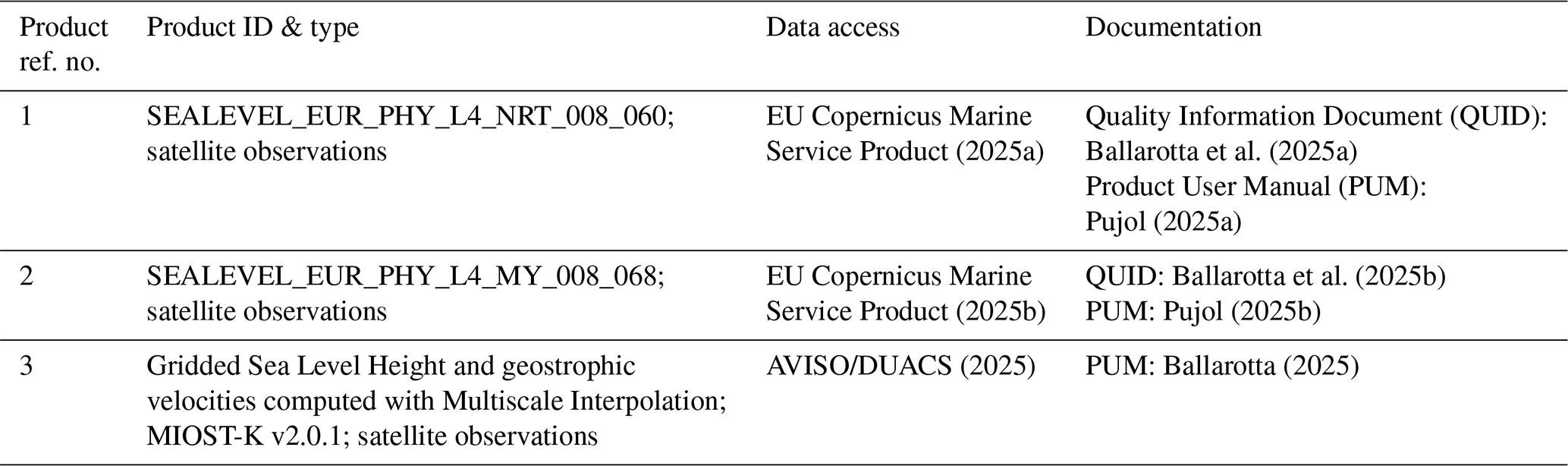
The European Seas Gridded L4 Sea Surface Height dataset (Table 1, product reference 1 and 2) from the Copernicus Marine Service, provides Sea Level Anomaly (SLA) fields at ° resolution over European regional seas, at a daily temporal frequency. The product is generated by the Data Unification and Altimeter Combination System (DUACS) system (Centre National d'Etudes Spatiales/Collecte Localisation Satellites; CNES/CLS) using optimal interpolation of along-track altimeter measurements from multiple satellites (Le Traon et al., 1998). It includes SLA, Absolute Dynamic Topography (ADT), and derived surface geostrophic currents. ADT is obtained by adding the Mean Dynamic Topography (MDT) to SLA. The MDT used is the Mediterranean 2020 product (MDT_CMEMS_2020_MED, EU Copernicus Marine Service Product, 2024). The dataset, is available in Near-Real-Time (NRT, product reference 1) and delayed-time (DT, product reference 2), and supports studies of mesoscale and large-scale sea level variability (e.g. Pascual et al., 2007, 2009; Marcos et al., 2015; Taburet et al., 2019; Ballarotta et al., 2019; Sánchez-Román et al., 2023). The NRT data is updated daily, and at the moment of the study had a temporal coverage from 4 October 2022 to 25 November 2024, while the delayed-time data from 1 January 1992 to 31 December 2023. Therefore, the DT product is only used for the analysis of the mean circulation (Fig. 1), and the NRT product is used for the rest of analyses as it covers 2024.
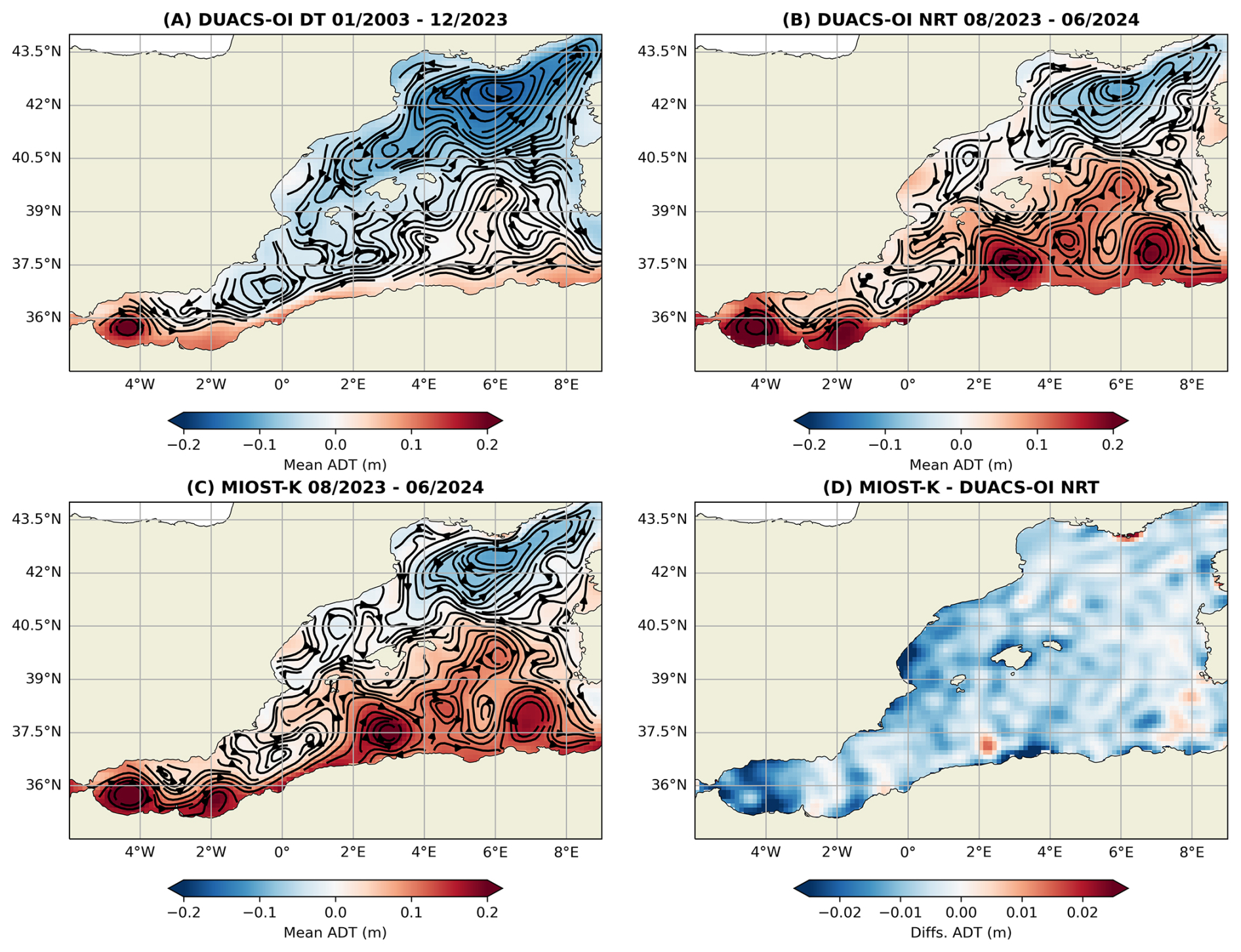
Figure 1General circulation represented by the mean Absolute Dynamic Topography (ADT) and the mean velocity field (streamlines) calculated from the different altimetric products: (A) 20 years mean from DUACS-DT (product reference 2), (B) 11 months mean of DUACS-NRT (product reference 1), (C) 11 months mean of MIOST-K (product reference 3) and (D) mean ADT difference between MIOST-K and DUACS-OI (C − B).
2.2 MIOST with SWOT KaRIn (MIOST-K)
The Multiscale Inversion of Ocean Surface Topography (MIOST) product (Table 1, product reference 3) is a new-generation gridded altimetry dataset that incorporates SWOT KaRIn data, i.e., two-dimensional swath (SSHA) observations. This global product is available at a spatial resolution of ° and at daily temporal frequency. We utilized the experimental L4 multimission sea level product distributed by AVISO v2.0.1, which combines SWOT swath altimetry with conventional nadir altimeter measurements. The dataset relies on the MIOST method (Ubelmann et al., 2021, 2022), a statistical technique that reconstructs sea surface height fields by decomposing variability across multiple spatial and temporal scales. The reconstruction combines SWOT KaRIn wide-swath observations, SWOT nadir data, and conventional nadir altimeter measurements within broad spatio-temporal windows around the target date. In Delayed-Time (DT) mode, both past and future observations are incorporated to constrain the interpolation process, with decreasing weights assigned to observations farther away in time. This allows mesoscale structures sampled during nearby overpasses to contribute to the reconstructed daily fields beyond the instantaneous SWOT and nadir ground-track coverage (see Fig. A1 for an example of the SWOT coverage contributing to the reconstruction of day 20 April 2024) (Ballarotta et al., 2025c). The MDT product used is also the MDT_CMEMS_2020_MED (EU Copernicus Marine Service Product, 2024). More details can be found in Ballarotta et al. (2025c) and Ballarotta (2025). These products were processed by SSALTO/DUACS and distributed by AVISO (https://www.aviso.altimetry.fr, last access: 22 April 2026) supported by CNES.
The inclusion of SWOT's Ka-band Radar Interferometer (KaRIn) observations improves the resolution of SSH fields, allowing finer-scale ocean dynamics (such as mesoscale and submesoscale structures) to be resolved. This experimental product (from hereinafter MIOST-K) provides daily gridded maps of SSH and derived geostrophic velocities, offering new opportunities to study ocean surface variability at unprecedented detail (Ballarotta et al., 2025c).
3.1 Py-eddy tracker
The py-eddy-tracker is an eddy tracking algorithm based on geometric and physical techniques. It was firstly developed by Mason et al. (2014) and later updated by Delepoulle et al. (2022). Since then, it has been widely used to study eddies and for the generation of updated eddy field datasets (e.g. Pegliasco et al. 2022). In this study, we use version 3.6.1 of the algorithm (Delepoulle et al., 2022) to identify eddies from daily snapshots of Absolute Dynamic Topography (ADT) fields. Two types of contours are identified by the algorithm: the effective contour (outermost closed contour defining the eddy extent) and the speed contour (inner contour corresponding to the region of maximum mean azimuthal geostrophic velocity). Further details can be found in Mason et al. (2014). Compared to SLA, ADT provides more reliable eddy identification, especially in the Mediterranean Sea (Pegliasco et al., 2021, 2022), because it includes both the mean dynamic topography and its temporal variability, helping distinguish mesoscale eddies from variations in persistent jets and recurrent circulation patterns included in the MDT. A pre-processing and set of parameterizations are necessary to implement the py-eddy tracker (see Mason et al., 2014; Pegliasco et al., 2022 for further details):
-
The ADT fields are filtered with a Bessel high-pass filter of 500 km to remove the background large-scale signal and isolate the eddies (Pegliasco et al., 2022).
-
A detection step of 0.002 m was used between consecutive isolines. This corresponds to the height difference between contour levels used to identify eddy boundaries. Starting from the eddy center (defined by a minimum value for cyclonic eddies and a maximum value for anticyclonic eddies), closed ADT isolines are identified outward at intervals of 0.002 m until the eddy edge is reached (Cui et al., 2025).
-
A maximum shape error of 55 % is allowed for a detected contour to be identified as an effective eddy. This metric is defined as the ratio between the circle fit and identified outermost contour. This shape error (Kurian et al., 2011) limits the identification to eddies, and removes other elongated closed-contour structures like filaments (Mason et al., 2019).
3.2 Particle simulations and eddy retention calculation
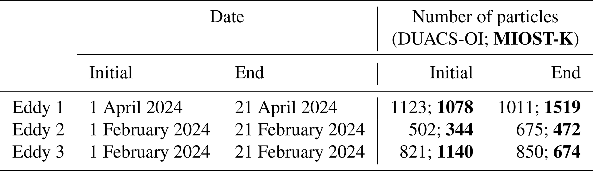
We calculate the eddy particle retention to quantify how differences in eddy properties, such as size, intensity, and associated EKE, influence particle transport and trapping. For this analysis, Lagrangian simulations are performed using the OceanParcels Lagrangian framework v2.4.2 (Delandmeter and van Sebille, 2019) to simulate 2D trajectories of virtual particles at the sea surface. Particles are advected using the velocity fields of the two datasets (DUACS-OI and MIOST-K). A fourth order Runge-Kutta particle advection scheme is used with a run-time time-step (dt) of 25 min. Particles are treated as infinitesimal, passive and buoyant tracers transported exclusively by horizontal advection, with no additional physical processes included. Simulations are performed with particles released within a 2 by 2° box around identified Algerian eddies' contours separated by ° (∼ 3.5 km) with an advection time (T) of 20 d. The inner (speed) eddy contour is used here, to keep the eddy's more coherent inner core. This timescale represents a trade-off between the minimum lifetime of the Algerian eddies (∼ 60 d) and the requirement that enough particles remain within the eddy core during the simulation. Particles which leave the domain are removed from the analysis. Here we showcase the impact on the retention capacity by selecting 3 Algerian eddies as representative examples. Further details are shown in Table C1.
Next, the eddy retention is calculated as the relative difference in the number of particles enclosed by the eddy contour between the release day and 20 d later. The Eddy Retention Percentage (ERP) is then calculated as:
where NT and N0 are the number of particles at the final and the release days, respectively.
The general circulation of the western Mediterranean has been thoroughly studied in the past. The new SWOT data is unveiling smaller oceanic scales and partially or even unobserved dynamics, but the impact of this on the general circulation patterns will be better understood when we have more years of SWOT data. Currently, with more than one year of SWOT data during the science phase, we can already infer a first estimate of how and if these general circulation patterns are affected by this new dataset, and thus the consequences this could have for different monitoring efforts (Fig. 1). Figure 1A is included as a reference representation of the mean circulation over 20 years in the western Mediterranean. The main circulation features shown in Fig. 1A are also observed in the shorter-term averages shown in Fig. 1B and C, indicating that the large-scale circulation is consistently represented in both datasets. Differences between Fig. 1B and C arise mainly at the smaller-scale features and in the characteristics of the mesoscale structures, already suggesting that the inclusion of SWOT observations impacts the representation of mesoscale circulation. Although part of these differences may also arise from intrinsic methodological differences between the DUACS-OI and MIOST reconstruction approaches, previous comparisons based solely on nadir altimetry showed relatively small differences between the two products in the Mediterranean (Ballarotta et al., 2023; Verbrugge et al., 2024). This suggests that the higher differences observed here are strongly influenced by the inclusion of SWOT wide-swath observations in MIOST-K. These differences are further highlighted in the mean ADT difference field shown in Fig. 1D, particularly in coastal regions and along energetic circulation pathways (e.g. Alboran Sea and Algerian Current). However, the magnitude of these differences is about an order of magnitude smaller than the values in the ADT field (note the limits of colorbar in Fig. 1B, C and D). This is expected from the enhanced spatial sampling provided by SWOT wide-swath observations compared to conventional nadir altimetry (e.g. Lopez-Radcenco et al., 2019; Ballarotta et al., 2025c), particularly for mesoscale and coastal structures (e.g. Dibarboure et al., 2025). In contrast to the effectively one-dimensional along-track sampling of nadir altimeters, SWOT provides two-dimensional swath measurements, and the implications of these differences are further explored through the analysis of daily eddy variability in the following sections.
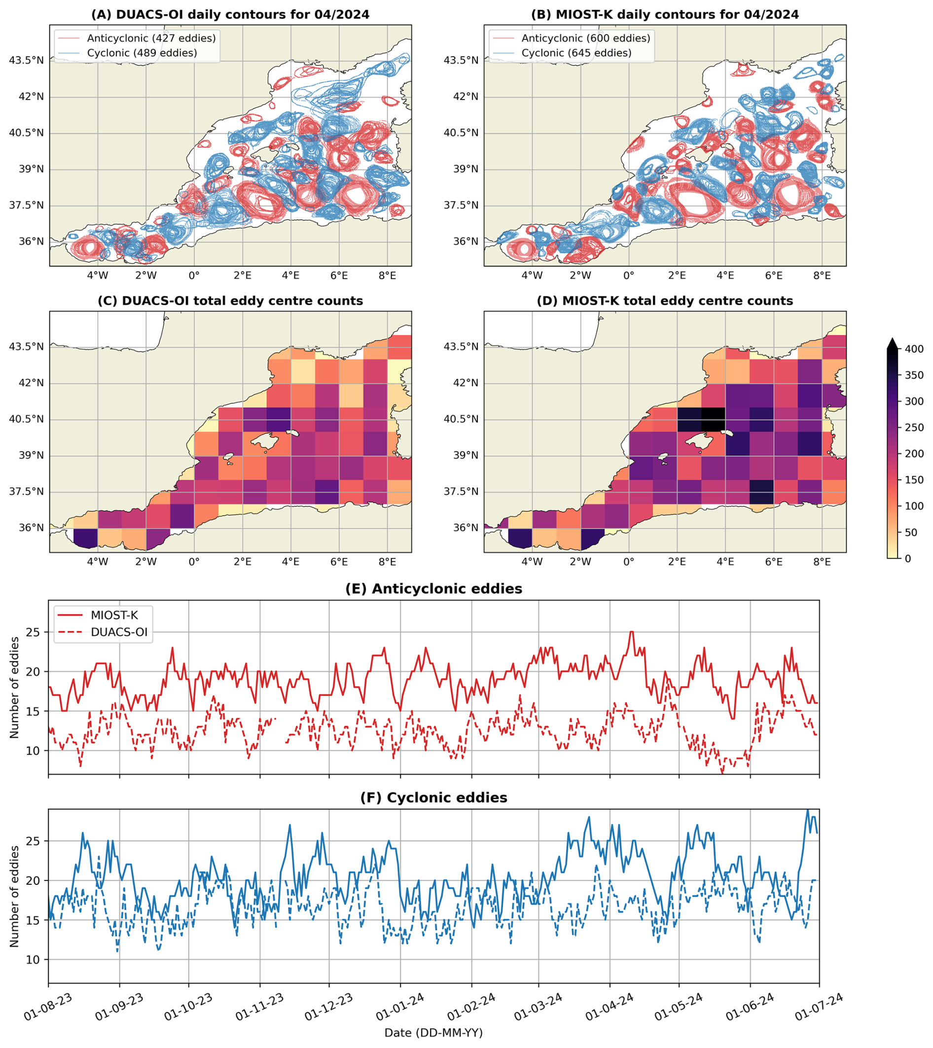
Figure 2Number of daily eddy identifications. Panels (A) and (B) show all the daily eddies (outer contours) identified during April 2024 for DUACS-OI (product reference 1) and MIOST-K (product reference 3), respectively. Panels (C) and (D) show the eddy centre counts in 1 × 1° bins, for DUACS-OI and MIOST-K, respectively. Panels (E) and (F) show the temporal variability of the anticyclones and cyclones, respectively, identified throughout the study period.
We obtain the daily eddy identification fields for both datasets from August 2023 to June 2024 (inclusive), and calculate the total number of cyclonic (blue) and anticyclonic (red) eddies. An example of all the eddies identified daily during April 2024 is shown in Fig. 2A and B for DUACS-OI and MIOST-K, respectively. The spatial distribution of eddy centre counts, computed in 1 by 1° bins over the full study period, is shown in Fig. 2C and D. Both products identify high eddy activity in the central and northwestern Mediterranean, and the Alboran Sea, although MIOST-K generally detects a larger number of eddies, particularly in coastal regions such as west of Corsica (also observed in Fig. 2A and B). Complementary observations, including satellite chlorophyll data, support the presence of coastal eddies in this region (Fig. B1; Fortunato et al., 2025). Moreover, the DUACS-OI product appears to merge multiple nearby cyclonic eddies into one larger structure, particularly in areas such as the Gulf of Lion, thereby reducing the number of identified eddies. The daily temporal variability of anticyclonic and cyclonic eddy counts is shown in Fig. 2E and F, respectively. Despite high temporal variability, MIOST-K consistently identifies a larger number of eddies than DUACS-OI throughout most of the analysis period. For anticyclonic eddies, MIOST-K detects on average 19.0 ± 2.0 eddies per day (mean ± standard deviation), compared to 12.5 ± 2.0 for DUACS-OI. For cyclonic eddies, the mean daily counts are 20.4 ± 3.1 and 16.6 ± 2.4 for MIOST-K and DUACS-OI, respectively. The temporal correlation between the two daily eddy-count time series is low for both anticyclonic (r=0.253) and cyclonic eddies (r=0.165). This likely reflects the sensitivity of daily eddy counts to product-dependent differences not only in eddy detection, but also splitting, merging, and lifetime, rather than fundamental differences in the temporal variability of mesoscale activity.
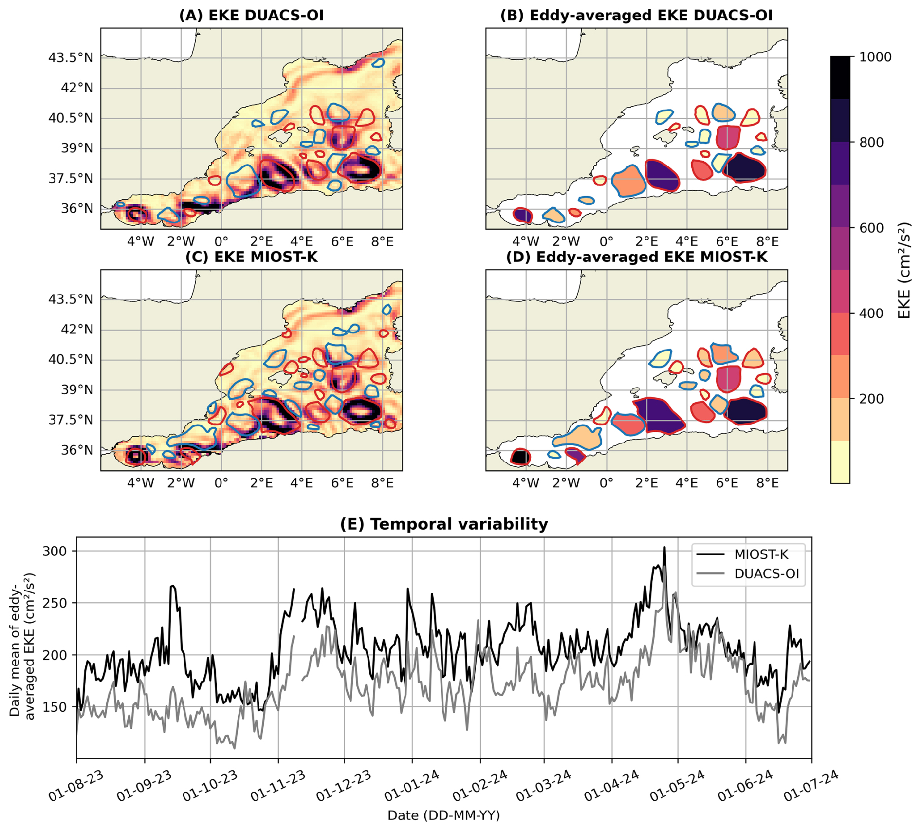
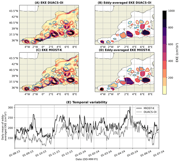
Figure 3Temporal variability of Eddy Kinetic Energy (EKE) associated with the detected eddies. Panels (A) and (C) show the EKE field on 20 April 2024 and all the identified anticyclonic (red) and cyclonic (blue) outer eddy contours, for DUACS-OI (product reference 1) and MIOST-K (product reference 3), respectively. Panels (B) and (D) show the individual eddy-averaged EKE of only the eddies identified in both datasets on that date. Panel (E) shows the temporal variability of the spatially averaged EKE within detected, matching eddy contours and averaged across all eddies for each day for DUACS-OI (dashed) and MIOST-K (solid).
With the inclusion of the SWOT data, we also observe changes in the already observed big mesoscale eddies of the DUACS-OI product. An important change is in the EKE associated with these eddies. Firstly, the EKE field is retrieved (Delepoulle et al., 2022; py-eddy-tracker, 2022) for each daily field (Fig. 3A and C). Then we find the eddies that match for both datasets and calculate the mean EKE associated to these eddies. i.e., the eddy-averaged EKE (Fig. 3B and D). Figure 3E shows the temporal variability of the daily mean of eddy-averaged EKE (daily mean EKE) of all the matching eddies identified. MIOST-K shows a higher daily mean throughout the majority of the study's time period. Both datasets reach their maximum during the same energetic event on 25 April 2024, although the MIOST-K value is approximately 6 % higher than in DUACS-OI. More importantly, specific daily differences between the products can be substantially larger, with MIOST-K exhibiting increases of up to 78 % relative to DUACS-OI during certain energetic mesoscale events, such as on 16 September 2023. On 96 % of the days, the daily mean in MIOST-K is higher than in DUACS-OI (we also checked the differences in the daily maximum of eddy-averaged EKE, and these are higher 93 % of the time). This enhanced EKE representation is likely associated with the improved spatial sampling, two-dimensional swath geometry, and enhanced representation of higher-wavenumber variability enabled by SWOT observations. Furthermore, SWOT observations are expected to exhibit substantially lower noise levels than conventional nadir altimeters (Vergara et al., 2023), which may also contribute to the differences observed. This has important implications for KE trend studies (e.g. Martínez-Moreno et al., 2019; Barceló-Llull et al., 2025), which in turn also can mean a challenge for current climate model projections (Barceló-Llull et al., 2025). For example, Hogg et al. (2015) mention the significant impact EKE trend variations have on the ocean's carbon and heat sinks in regions like the Southern Ocean, where increasing EKE has been associated with changes in the efficacy of these sinks and the consequent global climatic implications. In the western Mediterranean Sea, where mesoscale eddies strongly influence transport and exchanges between subbasins, the enhanced EKE representation identified in MIOST-K may similarly have important implications for regional heat, salt, and carbon-related transport processes. For example, the higher EKE observed in the energetic Alboran Sea eddies shown in Fig. 3 could affect the representation of heat and salt exchanges through the Strait of Gibraltar (e.g. Bryden et al., 1994; Tsimplis and Bryden, 2000; Sánchez-Román et al., 2009; Hargous et al., 2026). Such differences in EKE and mesoscale structure representation may also influence particle transport and retention estimates, with implications for marine pollution management and offshore spatial planning, as explored in the Algerian eddy case study presented in the following section.
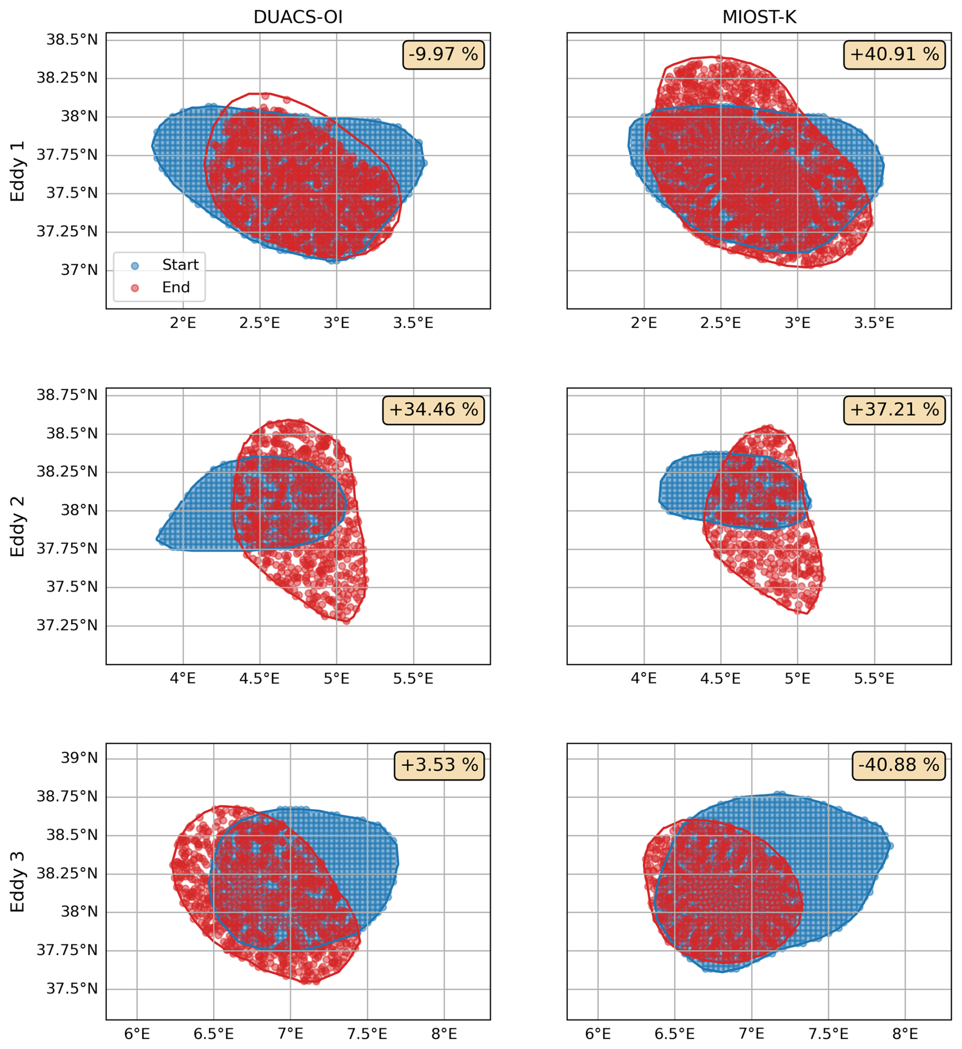
Figure 4Eddy retention capacity of three Algerian Eddies examples for DUACS-OI (left panels, product reference 1) and MIOST-K (right panels, product reference 3). Blue (red) particles and contours (inner eddy contours) correspond to the initial (final) dates (see Table C1). Only particles inside the eddy contours are shown. The top right box indicates the eddy retention percentage, with positive (negative) values indicating retention (leakage).
Figure 4 illustrates three examples of Algerian Eddies and their retention capacity. All three eddies were observed in different regions of the Algerian Basin during multiple SWOT KaRIn overpasses throughout their respective 20 d advection periods (approximately five overpasses for each case), supporting the use of these examples to assess the influence of SWOT-enhanced reconstruction on particle retention estimates. After 20 d, the eddies retain substantially different percentages of particles, reflecting the strong variability in mesoscale transport and retention processes across the subbasin. Such differences are expected between Algerian eddies, as their retention capacity can depend on their dynamical state, including eddy intensity, coherence, deformation, interaction with the surrounding circulation, and eddy lifetime stage. We therefore consider three different eddy examples to illustrate how differences in mesoscale representation between DUACS-OI and MIOST-K can impact transport and retention estimates under different dynamical conditions. In Eddy 1, the DUACS-OI eddy shows leakage, while the MIOST-K eddy retains and even increases the number of particles inside the eddy contour. In Eddy 2, both products retain more particles, although retention is slightly higher in MIOST-K. In contrast, Eddy 3 exhibits stronger leakage in MIOST-K, while DUACS-OI retains slightly more particles. This demonstrates an important impact of the differences in eddy properties identified between the operational DUACS-OI and the new dataset, MIOST-K. Despite only subtle qualitative differences in eddy contours (Fig. 2), the particle retention over just 20 d shows high variability, likely linked to the higher EKE structures observed in the SWOT-enhanced product (Fig. 3). These differences are not only scientifically relevant but may also have practical implications for environmental monitoring and marine spatial planning. The same eddy can exhibit opposite retention and leakage behaviours depending on the product used. If applied operationally, such contrasting representations could lead to substantially different estimates of the transport and accumulation of pollutants, marine litter, nutrients, fish larvae, or aquaculture-derived waste, potentially influencing pollutant dispersion assessments, aquaculture site suitability, or ecosystem management strategies.
In this study, we highlight the value of incorporating wide-swath altimetric observations for advancing the representation of mesoscale ocean dynamics. A key dynamic property of mesoscale eddies is their associated EKE. Results indicate a notable increase in signal strength, with MIOST-K capturing regional means of daily EKE up to 1.8 times greater than DUACS-OI. This result is important due to its link with the understanding of atmosphere-ocean interactions, especially in the current climate change scenario. Better monitoring these structures, not only their occurrence, but their characteristics, is key for related monitoring studies of for example sea surface temperature, and marine operational activities such as forecasts of extreme events and marine fisheries management.
The increase in eddy detections with MIOST-K is more pronounced for anticyclonic eddies than for cyclonic eddies. Although the origin of this eddy asymmetry was not specifically investigated here, it may be related to the improved detection of smaller-scale and coastal eddies, where the differences between the products are strongest. In the western Mediterranean, anticyclonic eddies tend to be more persistent, coherent, and longer-lived than cyclonic eddies (Stegner et al., 2021), potentially increasing their detectability in SWOT products. Similar asymmetries have also been observed by SWOT in other regions, and are generally explained by the greater stability and propagation capacity of anticyclonic eddies, allowing them to persist longer and propagate farther (de Marez et al., 2026). This enhanced detection of anticyclonic eddies may also be relevant for the monitoring of long-lasting surface temperature anomalies associated with these structures, which could contribute to the development of local marine heatwaves (Aguiar et al., 2022).
We also observe clear changes in the retention capacity of Algerian eddies with MIOST-K over a 20 d period. This result has important consequences for marine pollution management strategies, namely those that can affect marine protected areas like the Cabrera National Park (Compa et al., 2020). This also influences the transport properties of these eddies related to the redistribution of temperature, salinity and nutrients, which influence the circulation of the area, and the nutrient inputs in other regions of the western Mediterranean Sea (e.g. Bryden et al., 1994; Hargous et al., 2026).
The eddy identification algorithm used to identify eddies is quite sensitive to pre-processing choices and parameterizations (e.g. Pegliasco et al., 2021), and could be refined in follow-up studies. Here it is used to compare 2 datasets, so the impact on the conclusions obtained should be minimal. The Eulerian method used here is commonly implemented in the community, namely in altimetry. Many other eddy identification and tracking techniques exist which use an Eulerian framework (e.g. Ioannou et al., 2024), but also Lagrangian ones, which could help to better capture retention capabilities, as Lagrangian structures could assess material coherence in space and time simultaneously (e.g. Beron-Vera et al., 2013; Haller et al., 2016; Liu et al., 2019). To further validate the robustness of our retention findings, future work could extend the Lagrangian analysis to a larger ensemble of eddies. Statistical comparison across datasets would help quantify whether observed differences are consistent and significant, and whether eddy properties such as size or eccentricity correlate with retention efficiency. This would also support the operational use of eddy-based transport estimates in pollution risk forecasting and coastal marine management. Lastly, we take advantage of a very novel dataset (MIOST-K), but it is under continuous improvement due to the young age of SWOT. It will be interesting to continue this study with a longer series of data to further evaluate these mesoscale eddies in the Mediterranean region and look further into the improvement of the coastal eddy field in the region (Fortunato et al., 2025).
It is worth mentioning that, by design, conventional interpolation methods tend to filter out small-scale features detected by SWOT, leading to an underrepresentation of fine-scale eddies (typically around 50 km in diameter, or < 100 km in wavelength) in Level-4 products such as DUACS and MIOST. Moreover, SWOT captures a broader range of high-resolution ocean dynamics, including nonlinear eddies and internal waves, that are beyond the reach of nadir altimeters and not resolved by current mapping techniques. Recent studies have shown that mesoscale eddies can be identified directly from SWOT wide-swath SSH observations (e.g. Verger-Miralles et al., 2025; de Marez et al., 2026; Han et al., 2026; Fu et al., 2026). This direct approach is less suited to larger eddies that extend beyond the swath, but preserves the fine-scale information contained in SWOT observations and avoids the smoothing introduced by Level-4 mapping. However, a key limitation lies in the coarse temporal sampling imposed by the 21 d repeat cycle of the science phase, which hinders the analysis of rapidly evolving fine-scale dynamics (Archer et al., 2025). To fully exploit SWOT's potential, especially at submesoscales, new frameworks are needed. Promising advances in this direction are emerging from data- and model-driven mapping approaches (e.g., Fablet et al., 2021; Le Guillou et al., 2023, 2025) and in the development of robust validation strategies tailored to SWOT observations (Coadou-Chaventon et al., 2025; Verger-Miralles et al., 2025).
This study provides new insights on how the monitoring capabilities of surface circulation, namely mesoscale activity, will improve with the new wide-swath satellites such as SWOT. This is relevant to improve operational oceanography services, for example in managing and forecasting marine pollution events. The objective is to assess changes in the mesoscale eddy field by quantifying eddy count, variability, and associated kinetic energy. We then examine how the detected eddy properties affect their retention capacity. While this study is not intended as a comprehensive intercomparison of the DUACS-OI and MIOST-K products, it does show how the surface currents monitoring scenario might change in the near future, opening the door to a better representation of the different processes involved and its implications.
The results show the promising potential of new wide-swath products to better understand the eddy field, achieving specific capacities, particularly for observing small mesoscale eddies and resolving features in coastal areas. We also find that the already observed mesoscale eddy field by conventional products (DUACS-OI) has notable differences when compared to new products including SWOT (MIOST-K). An increase in Eddy Kinetic Energy (EKE) is found, which plays a vital role in the Mediterranean Sea by driving the variability of ocean circulation, redistributing heat, salt, and nutrients, and supporting marine productivity in this climatically sensitive region. Mesoscale eddies, which contribute to EKE, influence biological hotspots, the dispersion of pollutants, marine heatwaves and local weather patterns such asMediterranean cyclones. Monitoring EKE is therefore essential for improving ocean forecasting, managing fisheries, and understanding the impacts of climate change. This requires high-resolution observations from satellites, autonomous platforms, and regional cooperation to effectively track these dynamic processes and inform environmental management and policy. With this new dataset, the gap of high-resolution satellite data is further filled. The retention capacity of the eddies is strongly affected with this new data, meaning that once this data is incorporated into the operational products, a better estimation of marine pollution impacts will be possible. This will be of importance for different marine management strategies, especially those related to marine pollution and fisheries management.
Our findings demonstrate that incorporating SWOT wide-swath observations affects the representation of surface mesoscale features in the western Mediterranean, including in regions where conventional altimetry has limitations. By comparing eddy characteristics such as associated EKE and retention capacity, we show how these improvements can directly support marine applications such as pollution risk assessment for the protection of marine reserves. Looking ahead, the integration of next-generation satellite technologies and data-processing methodologies will be essential to further refine surface current products. This work contributes to a framework for ongoing monitoring and evaluation of regional circulation patterns, and underscores the importance of sustained innovation in ocean observing systems.
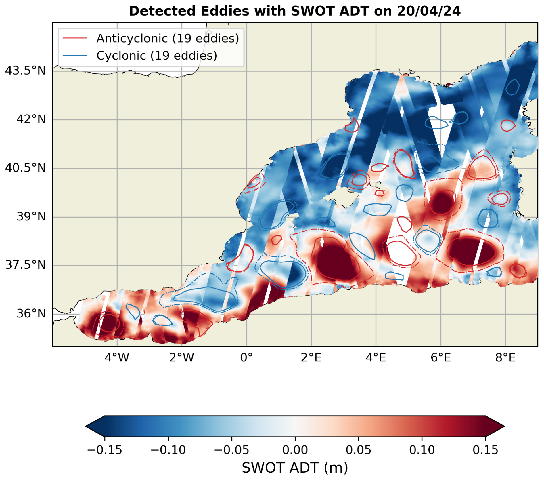
Figure A1Outer (dashed) and inner (solid) eddy contours identified with MIOST-K on 20 April 2024. The background fields are all the SWOT L3 ADT (filtered) [m] observations on 20 April 2024 ± 10 d. SWOT L3 LR ADT 2 km (Expert v2.0.1) data was obtained from AVISO (AVISO/DUACS, 2024).
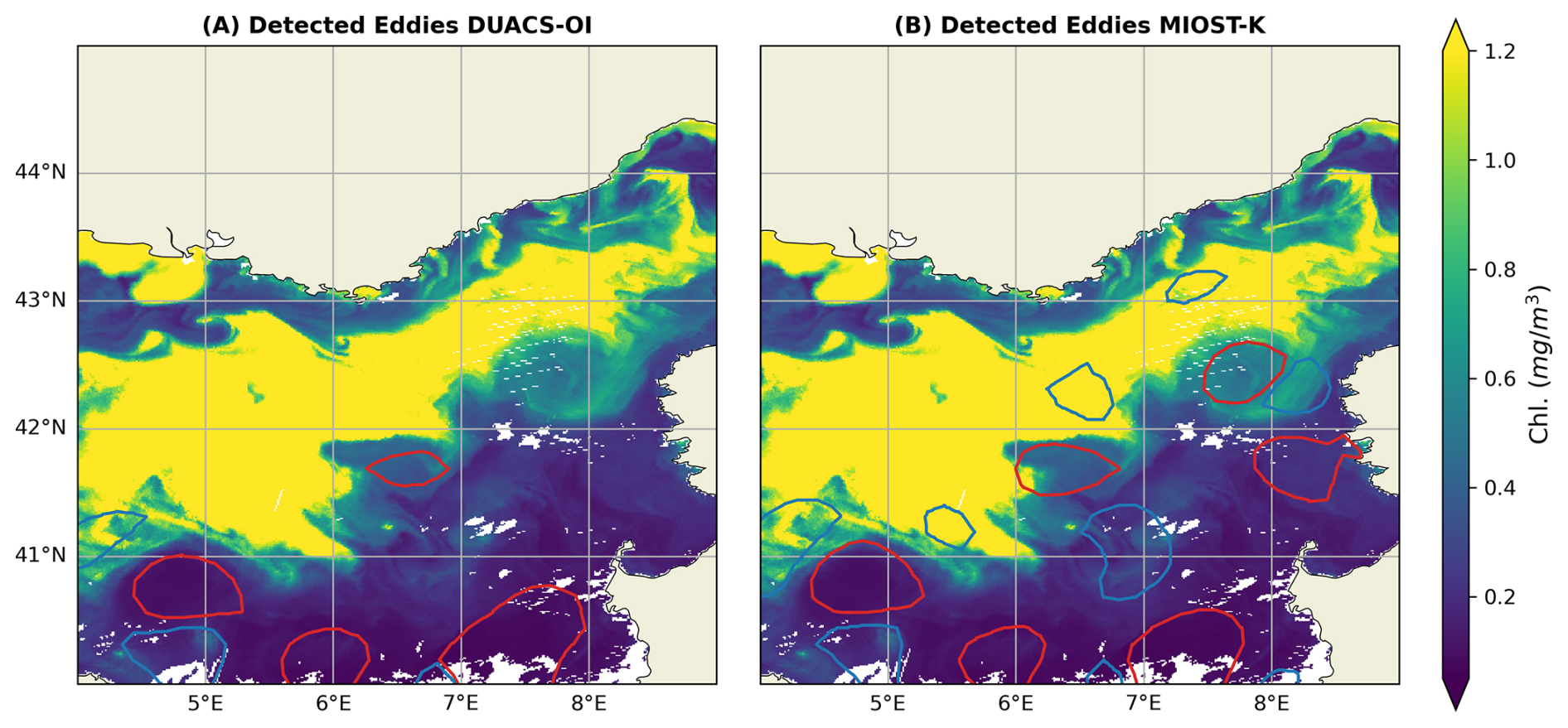
Figure B1Chlorophyll fields (Chl.) on 2 April 2024 with the corresponding eddy outer contours (anticyclonic red, cyclonic blue) for DUACS-OI (A) and MIOST-K (B). Daily level-3 chlorophyll a concentrations at 1 km spatial resolution were obtained from the multi-sensor dataset cmems_obs-oc_med_bgc-plankton_my_l3-multi-1km_P1D (E.U. Copernicus Marine Service Information, 2023; Berthon and Zibordi, 2004; Volpe et al., 2019).
The codes used in this study are available on GitHub: https://github.com/LauraGomezNavarro/paper-OSR10_Gomez-Navarro_etal_2026 (last access: 14 September 2026), and the version used for the manuscript is published on Zenodo: https://doi.org/10.5281/zenodo.22725565 (Gómez-Navarro, 2026).
The data used in this study can be downloaded directly from the Copernicus Marine Service and the AVISO websites. The exact product names are given in Table 1, and the associated DOIs are indicated in the references.
LGN, AP, MIP, MB, DCM, and LF contributed to the conceptualization of the study. LGN carried out the formal analysis, investigation, and prepared the original draft of the manuscript. DCM, AP, and LGN developed the methodology. MIP and MB curated the data. All authors contributed to the review and editing of the manuscript.
The contact author has declared that none of the authors has any competing interests.
The Copernicus Marine Service offering is regularly updated to ensure it remains at the forefront of user requirements. In this process, some products may undergo replacement or renaming, leading to the removal of certain product IDs from the catalogue. If readers have any questions or require assistance regarding these modifications, please feel free to reach out to the Copernicus Marine Service user support team for further guidance. They will be able to provide the necessary information to address concerns and find suitable alternatives.
Publisher's note: Copernicus Publications remains neutral with regard to jurisdictional claims made in the text, published maps, institutional affiliations, or any other geographical representation in this paper. The authors bear the ultimate responsibility for providing appropriate place names. Views expressed in the text are those of the authors and do not necessarily reflect the views of the publisher.
The authors gratefully acknowledge the helpful comments of the OSR coordination team, Karina von Schuckmann, Lorena Moreira and Alvaro de Pascual during the definition, implementation and writing of this study, and the feedback of the two anonymous reviewers. Additionally, the Copernicus Marine Service and AVISO are acknowledged for access to the datasets used for this work.
This study is funded by the Copernicus Marine Service (Sea-Level Thematic Center 24251L02-COP-TAC SL-2100). We also acknowledge funding from the Spanish Ministry of Science, Innovation, and Universities, the Spanish Research Agency, the European Regional Development Fund (MCIN/AEI/10.13039/501100011033/FUE) under Grant PID2021-122417NB-I00 (FaSt-SWOT project). LGN is also grateful for current funding under the Marie Sklodowska-Curie Actions programme, funded by the European Union (HORIZON-MSCA-2023-PF RELACS, grant agreement no. 101155713), and funding from the Spanish government through the “Severo Ochoa Centre of Excellence” accreditation (CEX2019-000928-S).
This paper was edited by Gilles Garric and reviewed by two anonymous referees.
20minutos: El GOB denuncia la presencia de numerosos residuos plásticos en aguas del parque Nacional de Cabrera, https://www.20minutos.es/noticia/2517637/0/gob-denuncia-presencia-numerosos-residuos-plasticos-aguas-parque-nacional-cabrera/ (last access: 9 July 2025), 2015.
Aguiar, E., Mourre, B., Alvera-Azcárate, A., Pascual, A., Mason, E., and Tintoré, J.: Strong Long-Lived Anticyclonic Mesoscale Eddies in the Balearic Sea: Formation, Intensification, and Thermal Impact, J. Geophys. Res.-Oceans, 127, e2021JC017589, https://doi.org/10.1029/2021JC017589, 2022.
Archer, M., Wang, J., Klein, P., Dibarboure, G., and Fu, L.-L.: Wide-swath satellite altimetry unveils global submesoscale ocean dynamics, Nature, 640, 691–696, https://doi.org/10.1038/s41586-025-08722-8, 2025.
AVISO/DUACS: SWOT level-3 KaRIn low rate SSH expert (v2.0.1) dataset, CNES [data set], https://doi.org/10.24400/527896/A01-2023.018, 2024.
AVISO/DUACS: SALTO/DUACS Mutlimission Experimental Level-4 maps, computed with SWOT Level-3 products (using both KaRIn and nadir instruments) (v2.0.1), CNES [data set], https://doi.org/10.24400/527896/a01-2025.001, 2025.
Ballarotta, M.: SSALTO/DUACS Experimental Product Handbook: Gridded Sea Level Heights and geostrophic velocities computed with SWOT Level-3 products (using both KaRIn and nadir instruments) with MIOST Version 2.0.1., Issue 2.1, AVISO, https://www.aviso.altimetry.fr/fileadmin/documents/data/tools/hdbk_duacs_experimental_miost_swot_v2.1.pdf (last access: 22 April 2026), 2025.
Ballarotta, M., Ubelmann, C., Pujol, M.-I., Taburet, G., Fournier, F., Legeais, J.-F., Faugère, Y., Delepoulle, A., Chelton, D., Dibarboure, G., and Picot, N.: On the resolutions of ocean altimetry maps, Ocean Sci., 15, 1091–1109, https://doi.org/10.5194/os-15-1091-2019, 2019.
Ballarotta, M., Ubelmann, C., Veillard, P., Prandi, P., Etienne, H., Mulet, S., Faugère, Y., Dibarboure, G., Morrow, R., and Picot, N.: Improved global sea surface height and current maps from remote sensing and in situ observations, Earth Syst. Sci. Data, 15, 295–315, https://doi.org/10.5194/essd-15-295-2023, 2023.
Ballarotta, M., Pujol, M.-I., and SL-TAC team: EU Copernicus Marine Service Quality Information Document for the European Seas Gridded L4 Sea Surface Heights And Derived Variables NRT, SEALEVEL_EUR_PHY_L4_NRT_008_060, Issue 13.0, Mercator Ocean International, https://documentation.marine.copernicus.eu/QUID/CMEMS-SL-QUID-008-032-068.pdf (last access: 16 July 2025), 2025a.
Ballarotta, M., Pujol, M.-I., and SL-TAC team: EU Copernicus Marine Service Quality Information Document for the European Seas Gridded L4 Sea Surface Heights And Derived Variables Reprocessed 1993 Ongoing, SEALEVEL_EUR_PHY_L4_MY_008_068, Issue 13.0, Mercator Ocean International, https://documentation.marine.copernicus.eu/QUID/CMEMS-SL-QUID-008-032-068.pdf (last access: 16 July 2025), 2025b.
Ballarotta, M., Ubelmann, C., Bellemin-Laponnaz, V., Le Guillou, F., Meda, G., Anadon, C., Laloue, A., Delepoulle, A., Faugère, Y., Pujol, M.-I., Fablet, R., and Dibarboure, G.: Integrating wide-swath altimetry data into Level-4 multi-mission maps, Ocean Sci., 21, 63–80, https://doi.org/10.5194/os-21-63-2025, 2025c.
Barceló-Llull, B., Rosselló, P., Combes, V., Sánchez-Román, A., Pujol, M. I., and Pascual, A.: Kuroshio Extension and Gulf Stream dominate the Eddy Kinetic Energy intensification observed in the global ocean, Sci. Rep., 15, https://doi.org/10.1038/s41598-025-06149-9, 2025.
Beron-Vera, F. J., Wang, Y., Olascoaga, M. J., Goni, G. J., and Haller, G.: Objective Detection of Oceanic Eddies and the Agulhas Leakage, J. Phys. Oceanogr., 43, https://doi.org/10.1175/JPO-D-12-0171.1, 2013.
Berthon, J.-F. and Zibordi, G.: Bio-optical relationships for the northern Adriatic Sea, Int. J. Remote Sens., 25, 1527–1532, https://doi.org/10.1080/01431160310001592544, 2004.
Bryden, H. L., Candela, J., and Kinder, T. H.: Exchange through the Strait of Gibraltar, Prog. Oceanogr., 33, 201–248, https://doi.org/10.1016/0079-6611(94)90028-0, 1994.
Coadou-Chaventon, S., Swart, S., Novelli, G., and Speich, S.: Resolving Sharper Fronts of the Agulhas Current Retroflection Using SWOT Altimetry, Geophys. Res. Lett., 52, https://doi.org/10.1029/2025gl115203, 2025.
Compa, M., Alomar, C., Mourre, B., March, D., Tintoré, J., and Deudero, S.: Nearshore spatio-temporal sea surface trawls of plastic debris in the Balearic Islands, Mar. Environ. Res., 158, 104945, https://doi.org/10.1016/j.marenvres.2020.104945, 2020.
Cotroneo, Y., Celentano, P., Aulicino, G., Perilli, A., Olita, A., Falco, P., Sorgente, R., Ribotti, A., Budillon, G., Fusco, G., and Pessini, F.: Connectivity Analysis Applied to Mesoscale Eddies in the Western Mediterranean Basin, Remote Sensing, 13, 4228, https://doi.org/10.3390/rs13214228, 2021.
Cui, A., Zhang, Z., Yan, H., and Han, B.: Spatial and Temporal Characteristics of Mesoscale Eddies in the North Atlantic Ocean Based on SWOT Mission, Remote Sens., 17, 1469, https://doi.org/10.3390/rs17081469, 2025.
Delandmeter, P. and van Sebille, E.: The Parcels v2.0 Lagrangian framework: new field interpolation schemes, Geosci. Model Dev., 12, 3571–3584, https://doi.org/10.5194/gmd-12-3571-2019, 2019.
Delepoulle, A., Mason, E., Busché, C., Pegliasco, C., Capet, A., Troupin, C., and Koldunov, N.: AntSimi/pyeddy-tracker: v3.6.1, Zenodo [code], https://doi.org/10.5281/zenodo.6333988, 2022.
de Marez, C., Bendinger, A., and Dilmahamod, A. F.: High-latitude eddy statistics from SWOT compared with in situ observations, Ocean Sci., 22, 1515–1528, https://doi.org/10.5194/os-22-1515-2026, 2026.
Diario de Mallorca: Casi la totalidad de los residuos de Cabrera son plásticos, https://www.diariodemallorca.es/mallorca/2022/04/18/totalidad-residuos-cabrera-son-plasticos-65095274.html (last access: 9 July 2025), 2022.
Dibarboure, G., Anadon, C., Briol, F., Cadier, E., Chevrier, R., Delepoulle, A., Faugère, Y., Laloue, A., Morrow, R., Picot, N., Prandi, P., Pujol, M.-I., Raynal, M., Tréboutte, A., and Ubelmann, C.: Blending 2D topography images from the Surface Water and Ocean Topography (SWOT) mission into the altimeter constellation with the Level-3 multi-mission Data Unification and Altimeter Combination System (DUACS), Ocean Sci., 21, 283–323, https://doi.org/10.5194/os-21-283-2025, 2025.
Escudier, R., Mourre, B., Juza, M., and Tintoré, J.: Subsurface circulation and mesoscale variability in the Algerian subbasin from altimeter-derived eddy trajectories, J. Geophys. Res.-Oceans, 121, 6310–6322, https://doi.org/10.1002/2016JC011760, 2016.
E.U. Copernicus Marine Service Information (CMEMS): Mediterranean Sea, Bio-Geo-Chemical, L3, daily Satellite Observations (1997–ongoing), Marine Data Store (MDS) [data set], https://doi.org/10.48670/moi-00299, 2023.
EU Copernicus Marine Service Product: Mediterranean Sea Mean Dynamic Topography, Mercator Ocean International [data set], https://doi.org/10.48670/moi-00151, 2024.
EU Copernicus Marine Service Product: European Seas Gridded L4 Sea Surface Heights And Derived Variables NRT, Mercator Ocean International [data set], https://doi.org/10.48670/moi-00142, 2025a.
EU Copernicus Marine Service Product: European Seas Gridded L4 Sea Surface Heights And Derived Variables Reprocessed 1993 Ongoing, Mercator Ocean International [data set], https://doi.org/10.48670/moi-00141, 2025b.
Fablet, R., Beauchamp, M., Drumetz, L., and Rousseau, F.: Joint Interpolation and Representation Learning for Irregularly Sampled Satellite-Derived Geophysical Fields, Front. Appl. Math. Stat., 7, 655224, https://doi.org/10.3389/fams.2021.655224, 2021.
Fortunato, L., Gómez-Navarro, L., Combes, V., Cotroneo, Y., Aulicino, G., and Pascual, A.: Coastal Eddy Detection in the Balearic Sea: SWOT Capabilities, Remote Sens., 17, 2552, https://doi.org/10.3390/rs17152552, 2025.
Fu, C., Han, X., Wang, Q., Pennelly, C., and Myers, P. G.: Wide-swath satellite altimetry reveals hotspots of small mesoscale eddies in the western Arctic Ocean, Commun. Earth Environ., 7, 344, https://doi.org/10.1038/s43247-026-03498-9, 2026.
Fu, L., Pavelsky, T., Cretaux, J., Morrow, R., Farrar, J. T., Vaze, P., Sengenes, P., Vinogradova-Shiffer, N., Sylvestre-Baron, A., Picot, N., and Dibarboure, G.: The Surface Water and Ocean Topography Mission: A Breakthrough in Radar Remote Sensing of the Ocean and Land Surface Water, Geophys. Res. Lett., 51, e2023GL107652, https://doi.org/10.1029/2023GL107652, 2024.
Gómez-Navarro, L.: LauraGomezNavarro/paper-OSR10_Gomez-Navarro_etal_2026: First release update (Version v1.0.2), Zenodo [code], https://doi.org/10.5281/zenodo.22725565, 2026.
Haller, G., Hadjighasem, A., Farazmand, M., and Huhn, F.: Defining coherent vortices objectively from the vorticity, J. Fluid Mech., 795, 136–173, https://doi.org/10.1017/jfm.2016.151, 2016.
Han, X., Wang, Q., Stewart, A. L., Wang, Z., Yang, Q., Ni, Q., Liu, C., and Chen, D.: High coastal eddy activity around Antarctica revealed by SWOT, Natl. Sci. Rev., 13, nwag181, https://doi.org/10.1093/nsr/nwag181, 2026.
Hargous, P., Combes, V., Barceló-Llull, B., and Pascual, A.: Eddy kinetic energy variability from 30 years of altimetry in the Mediterranean Sea, Ocean Sci., 22, 549–564, https://doi.org/10.5194/os-22-549-2026, 2026.
Hogg, A. M., Meredith, M. P., Chambers, D. P., Abrahamsen, E. P., Hughes, C. W., and Morrison, A. K.: Recent trends in the Southern Ocean eddy field, J. Geophys. Res.-Oceans, 120, 257–267, https://doi.org/10.1002/2014JC010470, 2015.
Ioannou, A., Guez, L., Laxenaire, R., and Speich, S.: Global Assessment of Mesoscale Eddies with TOEddies: Comparison Between Multiple Datasets and Colocation with In Situ Measurements, Remote Sens., 16, 4336, https://doi.org/10.3390/rs16224336, 2024.
Kurian, J., Colas, F., Capet, X., McWilliams, J. C., and Chelton, D. B.: Eddy properties in the California Current System, J. Geophys. Res., 116, C08027, https://doi.org/10.1029/2010JC006895, 2011.
Le Guillou, F., Gaultier, L., Ballarotta, M., Metref, S., Ubelmann, C., Cosme, E., and Rio, M.-H.: Regional mapping of energetic short mesoscale ocean dynamics from altimetry: performances from real observations, Ocean Sci., 19, 1517–1527, https://doi.org/10.5194/os-19-1517-2023, 2023.
Le Guillou, F., Chapron, B., and Rio, M.: VarDyn: Dynamical Joint‐Reconstructions of Sea Surface Height and Temperature From Multi‐Sensor Satellite Observations, J. Adv. Model. Earth Sy., 17, e2024MS004689, https://doi.org/10.1029/2024MS004689, 2025.
Le Traon, P. Y., Nadal, F., and Ducet, N.: An Improved Mapping Method of Multisatellite Altimeter Data, J. Atmos. Ocean. Tech., 15, 522–534, https://doi.org/10.1175/1520-0426(1998)015<0522:AIMMOM>2.0.CO;2, 1998.
Lopez-Radcenco, M., Pascual, A., Gómez-Navarro, L., Aissa-El-Bey, A., Chapron, B., and Fablet, R.: Analog Data Assimilation of Along-Track Nadir and Wide-Swath SWOT Altimetry Observations in the Western Mediterranean Sea, IEEE J. Sel. Top. Appl., 12, 2530–2540, https://doi.org/10.1109/JSTARS.2019.2903941, 2019.
Liu, T., Abernathey, R., Sinha, A., and Chen, D.: Quantifying Eulerian Eddy Leakiness in an Idealized Model, J. Geophys. Res.-Oceans, 124, 8869–8886, https://doi.org/10.1029/2019JC015576, 2019.
Marcos, M., Pascual, A., and Pujol, I.: Improved satellite altime- ter mapped sea level anomalies in the Mediterranean Sea: A comparison with tide gauges, Adv. Space Res., 56, 596–604, https://doi.org/10.1016/j.asr.2015.04.027, 2015.
Martínez-Moreno, J., Hogg, A. M., Kiss, A. E., Constantinou, N. C., and Morrison, A. K.: Kinetic Energy of Eddy-Like Features From Sea Surface Altimetry, J. Adv. Model. Earth Sy., 11, 3090–3105, https://doi.org/10.1029/2019MS001769, 2019.
Mason, E., Pascual, A., and McWilliams, J. C.: A New Sea Surface Height–Based Code for Oceanic Mesoscale Eddy Tracking, J. Atmos. Ocean. Tech., 31, 1181–1188, https://doi.org/10.1175/JTECH-D-14-00019.1, 2014.
Mason, E., Ruiz, S., Bourdalle-Badie, R., Reffray, G., García-Sotillo, M., and Pascual, A.: New insight into 3-D mesoscale eddy properties from CMEMS operational models in the western Mediterranean, Ocean Sci., 15, 1111–1131, https://doi.org/10.5194/os-15-1111-2019, 2019.
Morrow, R., Fu, L.-L., Ardhuin, F., Benkiran, M., Chapron, B., Cosme, E., d'Ovidio, F., Farrar, J. T., Gille, S. T., Lapeyre, G., Le Traon, P.-Y., Pascual, A., Ponte, A., Qiu, B., Rascle, N., Ubelmann, C., Wang, J., and Zaron, E. D.: Global Observations of Fine-Scale Ocean Surface Topography With the Surface Water and Ocean Topography (SWOT) Mission, Front. Mar. Sci., 6, 232, https://doi.org/10.3389/fmars.2019.00232, 2019.
Pascual, A., Pujol, M.-I., Larnicol, G., Le Traon, P.-Y., and Rio, M.-H.: Mesoscale mapping capabilities of multisatellite altimeter missions: First results with real data in the Mediterranean Sea, J. Mar. Syst., 211, 65, https://doi.org/10.1016/j.jmarsys.2004.12.004, 2007.
Pascual, A., Boone, C., Larnicol, G., and Le Traon, P.-Y.: On the Quality of Real-Time Altimeter Gridded Fields: Comparison with In Situ Data, J. Atmos. Ocean. Tech., 26, 556–569, https://doi.org/10.1175/2008jtecho556.1, 2009.
Pegliasco, C., Chaigneau, A., Morrow, R., and Dumas, F.: Detection and tracking of mesoscale eddies in the Mediterranean Sea: A comparison between the Sea Level Anomaly and the Absolute Dynamic Topography fields, Adv. Space Res., 68, 401–419, https://doi.org/10.1016/j.asr.2020.03.039, 2021.
Pegliasco, C., Delepoulle, A., Mason, E., Morrow, R., Faugère, Y., and Dibarboure, G.: META3.1exp: a new global mesoscale eddy trajectory atlas derived from altimetry, Earth Syst. Sci. Data, 14, 1087–1107, https://doi.org/10.5194/essd-14-1087-2022, 2022.
Pessini, F., Olita, A., Cotroneo, Y., and Perilli, A.: Mesoscale eddies in the Algerian Basin: do they differ as a function of their formation site?, Ocean Sci., 14, 669–688, https://doi.org/10.5194/os-14-669-2018, 2018.
Pujol, M.-I.: EU Copernicus Marine Service Product User Manual for the European Seas Gridded L4 Sea Surface Heights And Derived Variables NRT, SEALEVEL_EUR_PHY_L4_NRT_008_060, Issue 10.0, Mercator Ocean International, https://documentation.marine.copernicus.eu/PUM/CMEMS-SL-PUM-008-032-068.pdf (last access: 16 July 2025), 2025a.
Pujol, M.-I.: EU Copernicus Marine Service Product User Manual for the European Seas Gridded L 4 Sea Surface Heights And Derived Variables Reprocessed 1993 Ongoing, SEALEVEL_EUR_PHY_L4_MY_008_068, Issue 10.0, Mercator Ocean International, https://documentation.marine.copernicus.eu/PUM/CMEMS-SL-PUM-008-032-068.pdf (last access: 16 July 2025), 2025b.
py-eddy-tracker: Welcome to py-eddy-tracker’s documentation!, https://py-eddy-tracker.readthedocs.io/en/v3.6.1/ (last access: 8 July 2025), 2022.
Ruiz-Orejón, L. F., Mourre, B., Sardá, R., Tintoré, J., and Ramis-Pujol, J.: Quarterly variability of floating plastic debris in the marine protected area of the Menorca Channel (Spain), Environ. Pollut., 252, 1742–1754, https://doi.org/10.1016/j.envpol.2019.06.063, 2019.
Sánchez-Román, A., Sannino, G., García-Lafuente, J., Carillo, A., and Criado-Aldeanueva, F.: Transport estimates at the western section of the Strait of Gibraltar: A combined experimental and numerical modeling study, J. Geophys. Res.-Oceans, 114, https://doi.org/10.1029/2008JC005023, 2009.
Sánchez-Román, A., Pujol, M. I., Faugère, Y., and Pascual, A.: DUACS DT2021 reprocessed altimetry improves sea level retrieval in the coastal band of the European seas, Ocean Sci., 19, 793–809, https://doi.org/10.5194/os-19-793-2023, 2023.
Stegner, A., Vu, B. L., Dumas, F., Ghannami, M. A., Nicolle, A., Durand, C., and Faugere, Y.: Cyclone-Anticyclone asymmetry of eddy detection on gridded altimetry product in the Mediterranean Sea, J. Geophys. Res.-Oceans, 126, e2021JC017475, https://doi.org/10.1029/2021JC017475, 2021.
Suaria, G. and Aliani, S.: Floating debris in the Mediterranean Sea, Mar. Pollut. Bull., 86, 494–504, https://doi.org/10.1016/j.marpolbul.2014.06.025, 2014.
Taburet, G., Sanchez-Roman, A., Ballarotta, M., Pujol, M.-I., Legeais, J.-F., Fournier, F., Faugere, Y., and Dibarboure, G.: DUACS DT2018: 25 years of reprocessed sea level altimetry products, Ocean Sci., 15, 1207–1224, https://doi.org/10.5194/os-15-1207-2019, 2019.
Taupier-Letage, I., Puillat, I., Millot, C., and Raimbault, P.: Biological response to mesoscale eddies in the Algerian Basin, J. Geophys. Res., 108, https://doi.org/10.1029/1999JC000117, 2003.
Tsimplis, M. and Bryden, H.: Estimation of the transports through the Strait of Gibraltar, Deep-Sea Res. Pt. I, 47, 2219–2242, https://doi.org/10.1016/S0967-0637(00)00024-8, 2000.
Ubelmann, C., Dibarboure, G., Gaultier, L., Ponte, A., Ardhuin, F., Ballarotta, M., and Faugère, Y.: Reconstructing Ocean Surface Current Combining Altimetry and Future Spaceborne Doppler Data, J. Geophys. Res.-Oceans, 126, e2020JC016560, https://doi.org/10.1029/2020JC016560, 2021.
Ubelmann, C., Carrere, L., Durand, C., Dibarboure, G., Faugère, Y., Ballarotta, M., Briol, F., and Lyard, F.: Simultaneous estimation of ocean mesoscale and coherent internal tide sea surface height signatures from the global altimetry record, Ocean Sci., 18, 469–481, https://doi.org/10.5194/os-18-469-2022, 2022.
Última Hora: Un mar de plásticos, https://www.ultimahora.es/noticias/local/2015/07/23/157489/mar-plasticos.html (last access: 22 July 2025), 2015.
Verbrugge, N., Greiner E., Augot, J., Sammartino, M., Colella, S., Buongiorno-Nardelli, B., Hernandez-Carrasco, I., Falcini, F., Rossi, V., and Lacorata, G.: Algorithm Theoretical Baseline Document for 4DMED-SEA Project, version 2, ESA, http://ricerca.ismar.cnr.it/4DMED/docs/4DMED-SEA-D2_ATBD_v2.0-signed.pdf (last access: 15 June 2026), 2024.
Vergara, O., Morrow, R., Pujol, M.-I., Dibarboure, G., and Ubelmann, C.: Global submesoscale diagnosis using along-track satellite altimetry, Ocean Sci., 19, 363–379, https://doi.org/10.5194/os-19-363-2023, 2023.
Verger-Miralles, E., Mourre, B., Gómez-Navarro, L., Barceló-Llull, B., Casas, B., Cutolo, E., Díaz-Barroso, L., d'Ovidio, F., Tarry, D. R., Zarokanellos, N. D., and Pascual, A.: SWOT Enhances Small-Scale Eddy Detection in the Mediterranean Sea, Geophys. Res. Lett., 52, e2025GL116480, https://doi.org/10.1029/2025GL116480, 2025.
Volpe, G., Colella, S., Brando, V. E., Forneris, V., La Padula, F., Di Cicco, A., Sammartino, M., Bracaglia, M., Artuso, F., and Santoleri, R.: Mediterranean ocean colour Level 3 operational multi-sensor processing, Ocean Sci., 15, 127–146, https://doi.org/10.5194/os-15-127-2019, 2019.
Wang, H., Liu, Y., Yang, Y., Yan, R., and Wang, S.: Optimal Shipping Route under the Designation of the Mediterranean Sulfur Emission Control Area: Mathematical Models and Applications, Mathematics, 11, 4897, https://doi.org/10.3390/math11244897, 2023.