the Creative Commons Attribution 4.0 License.
the Creative Commons Attribution 4.0 License.
 | 02 Jun 2025 | OPSR | Chapter 3.1
A description of existing operational ocean forecasting services around the globe
Enrique Alvarez-Fanjul
Arthur Capet
Stefania Ciliberti
Emanuela Clementi
Boris Dewitte
Matias Dinápoli
Ghada El Serafy
Patrick Hogan
Sudheer Joseph
Yasumasa Miyazawa
Ivonne Montes
Diego A. Narvaez
Heather Regan
Claudia G. Simionato
Gregory C. Smith
Joanna Staneva
Clemente A. S. Tanajura
Pramod Thupaki
Claudia Urbano-Latorre
Jennifer Veitch
Jorge Zavala Hidalgo
Predicting the ocean state in support of human activities, environmental monitoring, and policymaking across different regions worldwide is fundamental. To properly address physical, dynamical, ice, and biogeochemical processes, numerical strategies must be employed. The authors provide an outlook on the status of operational ocean forecasting systems in eight key regions including the global ocean: the West Pacific and Marginal Seas of South and East Asia, the Indian Seas, the African Seas, the Mediterranean and Black Sea, the North East Atlantic, South and Central America, North America (including the Canadian coastal region, the United States, and Mexico), and the Arctic.
The authors initiate their discussion by addressing the specific regional challenges that must be addressed and proceed to discuss the numerical strategy and the available operational systems, ranging from regional to coastal scales. This compendium serves as a foundational reference for understanding the global offering, demonstrating how the diverse physical environment – ranging from waves to ice – and the biogeochemical features besides ocean dynamics can be systematically addressed through regular, coordinated prediction efforts.
-
Please read the editorial note first before accessing the article.
-
Article
(11281 KB)
-
Please read the editorial note first before accessing the article.
- Article
(11281 KB) - Full-text XML
- BibTeX
- EndNote


The vast and dynamic nature of the world's oceans plays a critical role in shaping global climate, supporting biodiversity, and sustaining human economies. Accurate ocean forecasting is essential for a variety of applications, including maritime navigation, fisheries' management, disaster preparedness, and climate research. As such, the ability to predict ocean conditions with precision is of paramount importance to scientists, policymakers, and coastal communities alike.
Over the past few decades, significant advancements have been made in the field of ocean forecasting, driven by improvements in observational technologies, numerical modeling, and computational capabilities. Satellite remote sensing, autonomous underwater vehicles, and enhanced buoy networks have expanded our ability to monitor oceanic parameters with unprecedented resolution and coverage. Concurrently, sophisticated numerical models, integrating physical, chemical, and biological processes, have improved the accuracy and reliability of ocean predictions.
Despite these advancements, the status of ocean forecasting varies widely across different regions of the world. Factors such as technological infrastructure, scientific expertise, and financial resources influence the development and implementation of forecasting systems. Some regions have established comprehensive and highly accurate forecasting capabilities, while others struggle with limited data availability and outdated methodologies.
This paper aims to provide a comprehensive overview of the current state of ocean forecasting services across various regions globally (reanalysis services are not contemplated). By examining the technological, scientific, and operational aspects of forecasting systems in different parts of the world, we seek to identify both the strengths and gaps in existing capabilities.
Figure 1The OceanPrediction DCC Atlas (https://www.unoceanprediction.org/en/atlas/models, last access: 8 May 2025).
The main inventory for operational ocean forecasting services existing today is the atlas of these services hosted on the OceanPrediction Decade Collaborative Center (DCC) website (https://www.unoceanprediction.org/en/atlas, last access: 8 May 2025) In this already growing inventory more than 150 worldwide systems are described in detail showing a comprehensive picture of the activity in this field (Fig. 1).
The following sections describe, starting with global systems and analyzing region by region, the situation across different regions of the world ocean.
Historically, global ocean forecasting efforts were initially focused on naval operations and scientific research, with early models developed to support strategic planning and military navigation. The advent of global observing systems, such as satellite altimetry and Argo floats, provided unprecedented datasets, leading to significant improvements in model accuracy.
With the establishment of initiatives such as the Global Ocean Data Assimilation Experiment (GODAE) in the late 1990s and early 2000s, operational oceanography moved toward a coordinated, global-scale framework. These efforts laid the foundation for modern global ocean forecasting services, which now provide continuous, high-resolution forecasts tailored for various sectors, including fisheries, shipping, offshore energy, and climate services.
Today, global operational ocean forecasting systems are operated by multiple institutions worldwide, using state-of-the-art ocean circulation and sea ice models coupled with data assimilation techniques. These models are forced by atmospheric reanalysis and forecast systems, integrating satellite and in situ observations to improve the accuracy of predictions. The outputs of these systems are crucial for understanding ocean dynamics, predicting extreme events such as hurricanes and marine heat waves, and supporting policy decisions related to climate change adaptation and marine resource management.
Table 1Global ocean forecasting services on the OceanPrediction DCC Atlas.
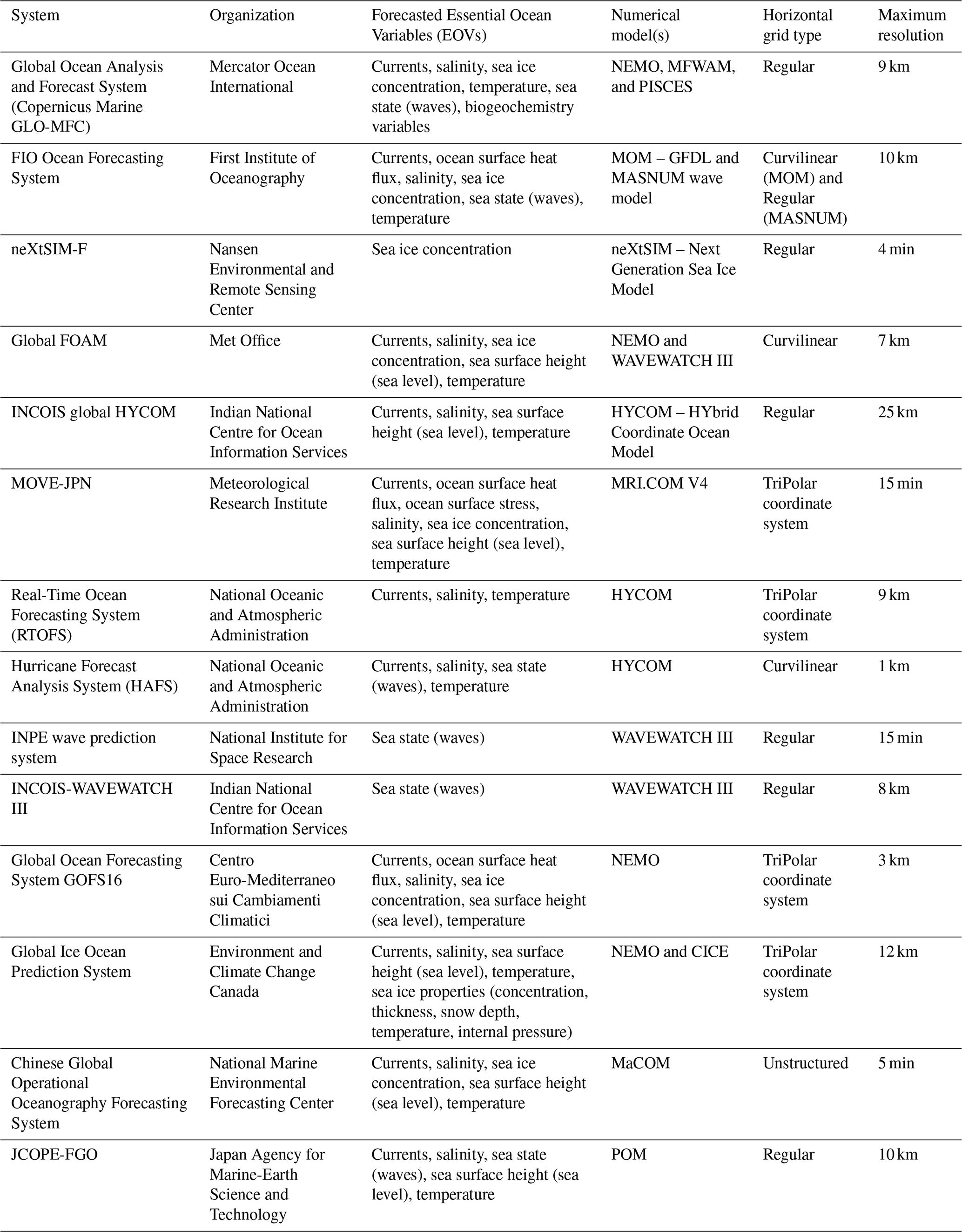
Table 1 shows the global systems already registered in the OceanPrediction DCC Atlas and their main characteristics. All the detailed information about these systems can be found at the OceanPrediction DCC Atlas. To the knowledge of the authors, only a few systems remain to be incorporated into this inventory: LICOM, operated by the Institute of Atmospheric Physics (China), and NAVY-ESPC and GOFS3, both developed by the Naval Research Laboratory (USA).
Other interesting characteristics can be derived from the replies not shown in the area. For the circulation models, the number of vertical layers ranges from 29 to 98, Z coordinates being the most used system (four systems). All the systems (except some wave systems) use data assimilation, but only two make use of ensemble techniques.
The data sources employed for assimilation change from one system to another, the ones used being ARGO profiles, satellite altimetry, satellite sea surface temperature (SST), buoy data, drifters, XBT, and gliders. Six systems use dynamic coupling between different models or model components. All systems, but one, provide third parties with data, directly or after a specific request. Surprisingly, almost half of the systems declare not being validated operationally. The forecast horizon is usually between 5 and 10 d.
It is interesting to note that in regions where regional and coastal systems are scarce, global services have become a main source of information for many applications. In African seas, for example, outputs from the global services are disseminated on a local web portal. Bandwidth is cited as the most common problem affecting the accessibility of global forecast services. Some countries provide bulletins in pdf format, and some add local value to global services by developing and disseminating optimized metrics. Examples of the variety of use types are provided here:
-
Mauritius (using Copernicus Marine Global Ocean Monitoring and Forecasting (GLO-MFC) products). The Mauritius Oceanography Institute provides a web portal, available at https://moi.govmu.org/gmes/forecast (last access: 8 May 2025) (affiliated with GMES and Africa) that outputs a regional subset of global sea-state forecasts. Monthly bulletins are targeted at users from the marine and fisheries' realm for monitoring purposes and are a source of information for researchers and the scientific community.
-
Kenya (using INCOIS). The Kenyan Meteorological Department provides daily and weekly marine forecast bulletins (https://meteo.go.ke/, last access: 8 May 2025).
-
Mozambique (using INCOIS). The Integrated Ocean and Information System for Mozambique is developed by the INCOIS project Hyderabad and the Regional Integrated Multi-Hazard Early Warning System (RIMES).
-
South Africa (using the NCEP Global Ensemble Forecast System – Wave (GFS-Wave), available at https://www.nco.ncep.noaa.gov/pmb/products/gfs/, last access: 8 May 2025, and Copernicus Marine GLO-MFC products). The South African Weather Service uses the National Centers for Environmental Prediction – Global Forecast System (NCEP GFS), as well as currents from the Copernicus Marine Service forecasts, to run an operational regional and coastal wave and storm surge model (Barnes and Rautenbach, 2020). Additionally, they disseminate regional information based on Copernicus Marine forecasts.
-
South Africa (using Copernicus Marine GLO-MFC products). Regional value was added to Copernicus Marine products, e.g., marine heat waves, location of the Agulhas Current (e.g., distance from shore), and SST anomalies in an operational service. The tools are currently being integrated into the web portal.
In the West Pacific and Marginal Seas of South and East Asia (WPMSEA), ocean forecasting systems are particularly important due to the region's vulnerability to tropical cyclones, tsunamis, and other oceanic phenomena, as well as socio-economic development needs.
Regional and coastal forecasts
In this region, it is very frequent that the regional systems also include nested coastal applications, so the description is merged into a single section.
The Japan Coastal Ocean Predictability Experiment (JCOPE; https://www.jamstec.go.jp/jcope/htdocs/e/jcope_consortium.html, last access: 8 May 2025) system, developed by the Japan Agency for Marine-Earth Sciences and Technology (JAMSTEC) based on the Princeton Ocean Model (POM; Blumberg and Mellor, 1987), is a dynamic ocean monitoring and forecasting system (Miyazawa et al., 2009, 2021). Originally tailored for the western North Pacific at eddy-resolving resolutions, JCOPE is now extended to cover the global ocean with a new eddy-resolving quasi-global ocean reanalysis product, the JCOPE Forecasting Global Ocean (JCOPE-FGO). The model covers the global ocean from 75° S to 75° N except for the Arctic Ocean, with a horizontal resolution of 0.1° × 0.1° and 44 sigma levels. The validation against observational data demonstrates JCOPE-FGO's effectiveness, while assessments using satellite data show its capability in representing upper-ocean circulation (Kido et al., 2022). The significance of river forcing for accurately representing seasonal variability is emphasized by highlighting the inclusion of updated global river runoff in JCOPE-FGO and its significant impacts on near-surface salinity.
Kyushu University in Japan operates several real-time ocean forecasting systems based on the Research Institute for Applied Mechanics Ocean Model (DREAMS; https://dreams-c1.riam.kyushu-u.ac.jp/vwp/html/vwp_about.html.ja, last access: 8 May 2025) system. This 3-dimensional ocean model is formulated in spherical coordinates with a horizontal resolution of approximately 1.5 km and features 114 vertical levels (Liu and Hirose, 2022). Its domain covers a rectangular region southwest of Japan, including part of the East China Sea Shelf and the deep Okinawa Trough.
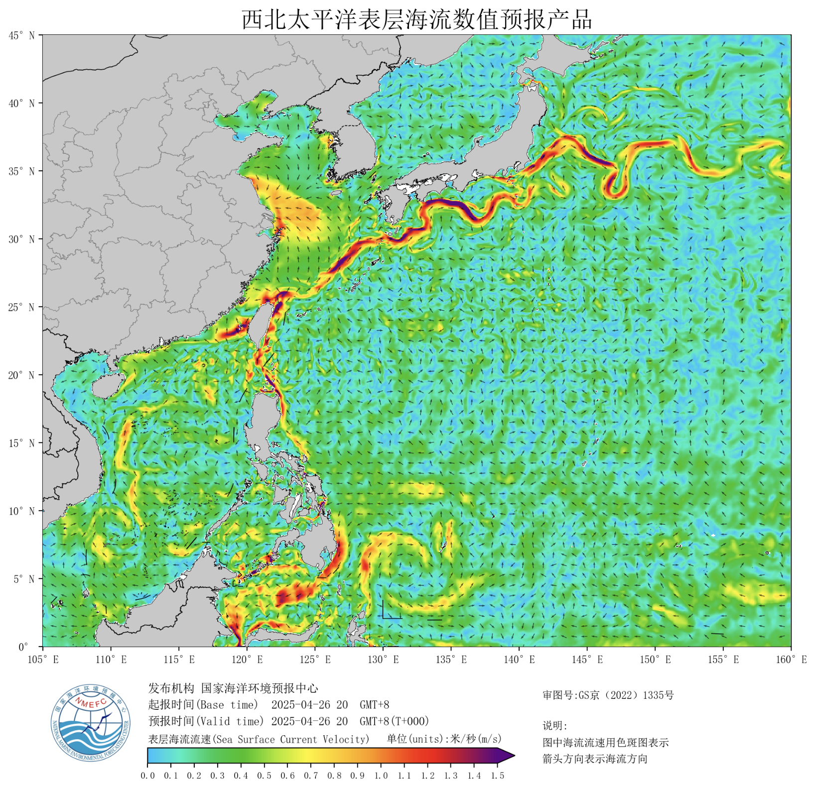
Figure 2Surface currents derived from the MaCOM system (source: https://english.nmefc.cn/ybfw/seacurrent/WestNorthPacific, last access: 8 May 2025).
The Mass Conservation Ocean Model (MaCOM) model (Feng et al., 2024) is a newly established and operated global circulation model developed at National Marine Environmental Forecasting Centre (NMEFC) in China (Fig. 2). This model adopts a complete physical framework, the key features of which are mass conservation, enthalpy conservation, and salt conservation, and which is based on pressure coordinates. The MaCOM system is used from global (∼ 10 km) to coastal (∼ 100 m) forecasts and replaces several previously used models in NMEFC. The LASG/IAP Climate System Ocean Model (LICOM) Forecast System (LFS) is another forecast system from China that maintains a horizontal resolution of 3600 × 2302 grids (°) and 55 vertical levels. Assessments indicate that LFS performs well in short-term marine environment forecasting. For example, LFS is also able to forecast the marine heat waves around the China Sea, especially in the South China Sea and East China Sea (Yiwen et al., 2023). The surface wave–tide–circulation coupled ocean model developed by the First Institute of Oceanography (FIO-COM) is another global model with an emphasis on tidal mixing (Qiao et al., 2019). The model is developed in close partnership with the Intergovernmental Oceanographic Commission of UNESCO Sub-Commission for the Western Pacific (WESTPAC). MaCOM ocean forecast systems also provide regional as well as coastal forecasts on scales from kilometers to meters with various applications from oil spill forecasts and fishery to ice drifts and marine heat waves.
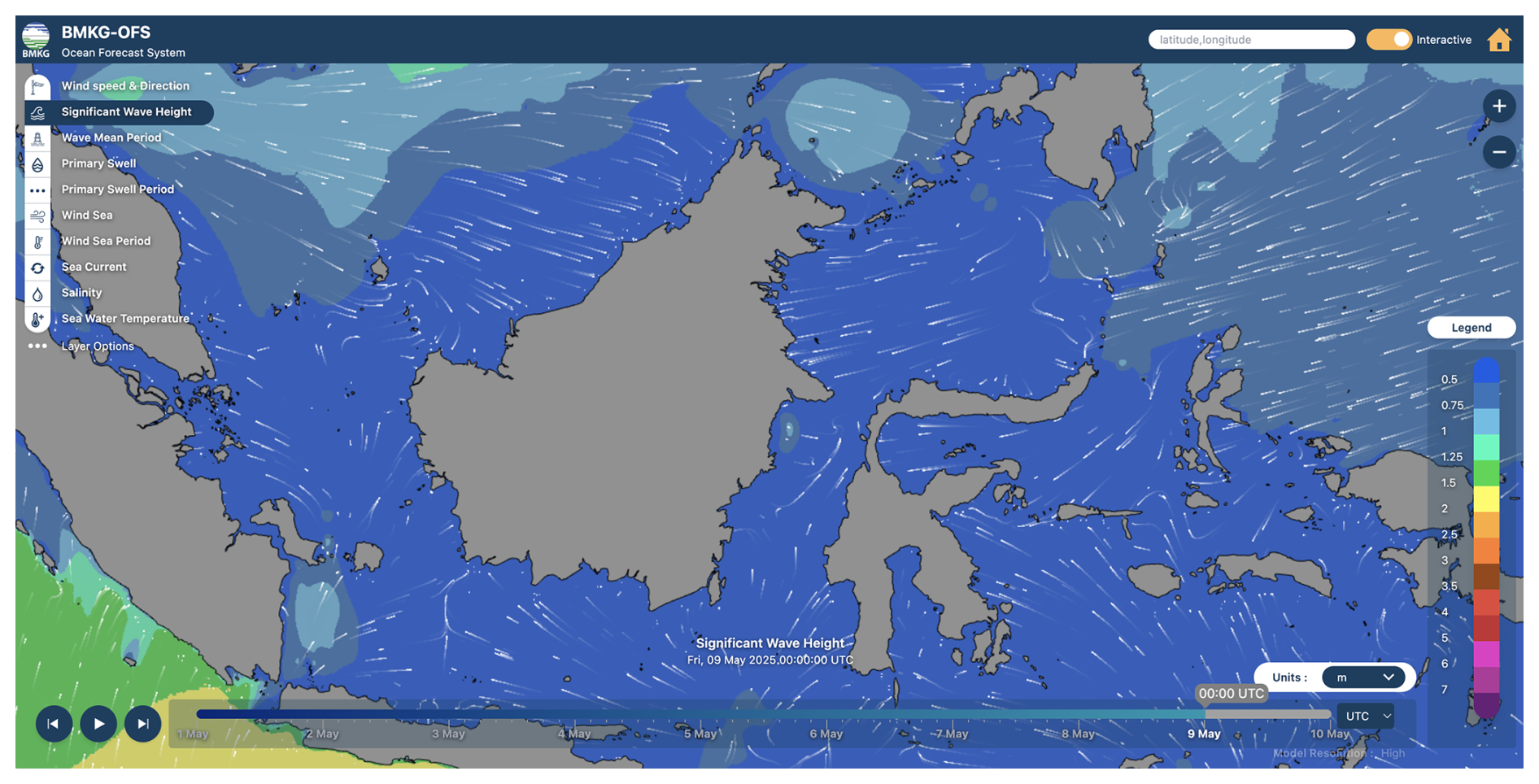
Figure 3Significant wave height derived from BKMG-OFS system (source: https://peta-maritim.bmkg.go.id/ofs/, last access: 14 May 2025).
The BMKG Ocean Forecast System (BMKG-OFS; https://maritim.bmkg.go.id/ofs, last access: 8 May 2025) is an advanced forecasting system developed by Indonesia's Meteorological, Climatological, and Geophysical Agency (BMKG) to provide accurate and timely oceanographic information for the Indonesian seas (Fig. 3). Launched in 2017, BMKG-OFS offers up to 7 d forecasts on various ocean parameters, including wind, waves, swell, currents, sea temperature, salinity, tides, sea level, and coastal inundation. The system utilizes the WAVEWATCH III model to predict sea wave conditions and the Finite Volume Community Ocean Model (FVCOM) to provide information on ocean currents, salinity, and sea temperature at various depths. There is a plan to improve the horizontal and vertical resolutions and an atmospheric-ocean-wave model.
Two major South Korean institutes, the Korea Hydrographic and Oceanographic Agency (KHOA) and the Korea Institute of Ocean Science and Technology (KIOST) (whose details are provided in the OceanPredict National Report, 2020, https://oceanpredict.org/science/operational-ocean-forecasting-systems/system-reports/, last access: 14 May 2025), operate ocean forecasting systems to support various activities. Since 2012, KHOA has operated the Korea Ocean Observing and Forecasting System (KOOFS), consisting of nested ocean and atmospheric models with horizontal resolutions ranging from 4 to 25 km. These models generate daily forecasting data covering regional, sub-regional, coastal, and port areas, with resolutions as fine as 0.1 km for major port areas.
Since 2017, KIOST has also operated the Ocean Predictability Experiment for Marine environment (OPEM) (Jin et al., 2024), a regional ocean prediction system that provides weekly 10 d forecasts for the western North Pacific and has shown strong performance in simulating ocean conditions around the Korean Peninsula, particularly in response to extreme events such as typhoons and coastal upwelling. In 2020, a sub-coastal model with a resolution of ∼ 300 m was established, nested within the coastal model, which itself has a resolution of 1 km. In addition to these major oceanographic centers, some universities are also developing coastal forecasting systems.
Bluelink (https://research.csiro.au/bluelink/global/forecast/, last access: 8 May 2025) is an Australian ocean forecasting initiative established in 2003 through a collaboration between the Commonwealth Scientific and Industrial Research Organisation (CSIRO), the Bureau of Meteorology, and the Australian Department of Defence. It aims to develop and maintain world-leading global, regional, and littoral ocean forecast systems to support defense applications and provide a national ocean forecasting capability for Australia. Bluelink's operational system, the Ocean Modelling and Analysis Prediction System (OceanMAPS; http://www.bom.gov.au/marine/index.shtml, last access: 8 May 2025), provides 7 d forecasts of ocean conditions, including currents, temperature, salinity, and sea level, on a near-global scale. These forecasts are crucial for various sectors, including maritime industries, defense applications, and climate research, aiding in decision-making and enhancing safety at sea (Brassington et al., 2023). Version 4, operational since 2022, uses the ensemble Kalman filter (EnKF).
Forecasting Essential Ocean Variables (EOVs) for the Indian Seas comes with several hurdles compared to other regions due to the complex nature of the ocean dynamics and the specific characteristics of the Indian Ocean region such as the land-locked northern boundary. Major processes that make forecasting difficult in the region include the monsoon system, which brings abrupt and significant variability in wind patterns, precipitation, and oceanic processes. The Indian Ocean is characterized by seasonally reversing circulation patterns under the influence of monsoonal winds, coastal upwelling, and interactions with neighboring ocean basins. Comprehensive and high-quality observational data for initializing and validating ocean forecast models are scarce, particularly in remote areas and during extreme weather events. The Indian Seas have a complex coastline with extensive estuaries, deltas, and coral reef systems. Coastal processes, including tides, waves, and sediment transport, interact with ocean circulation and impact nearshore areas. Accurately representing these coastal processes in forecasting models poses challenges due to the high spatial variability and the need for high-resolution data and modeling techniques.
4.1 Regional systems
The Indian National Centre for Ocean Information Services (INCOIS) operates two regional ocean forecasting systems utilizing the Hybrid Coordinate Ocean Model (HYCOM) and the Regional Ocean Modeling System (ROMS). The regional INCOIS-HYCOM has the highest resolution of approximately 6.9 km, followed by regional INCOIS-ROMS with approximately 9.2 km resolution. Regional INCOIS-HYCOM is forced with atmospheric variables from the NCEP GFS and uses and assimilates sea surface temperature (SST) data derived from the Advanced Very High Resolution Radiometer (AVHRR) sensor, along-track sea level anomalies, and in situ profiles from various observing platforms using the Tendral Statistical Interpolation (T-SIS) scheme data assimilation (DA) method (Srinivasan et al., 2022), taking boundary conditions from INCOIS global HYCOM described earlier (Table 1).
ROMS from INCOIS uses atmospheric forcing from the National Centre for Medium Range Weather Forecasting (NCMRWF; https://www.ncmrwf.gov.in/, last access: 8 May 2025) Unified Model (NCUM) atmospheric system. It assimilates SST and vertical profiles of temperature and salinity from in situ platforms using a local ensemble transform Kalman filter (LETKF) DA method. Data visualization and products from these models are available through a web interface (https://incois.gov.in/portal/osf/osf.jsp, last access: 8 May 2025) to users, and data are made available to users on request.
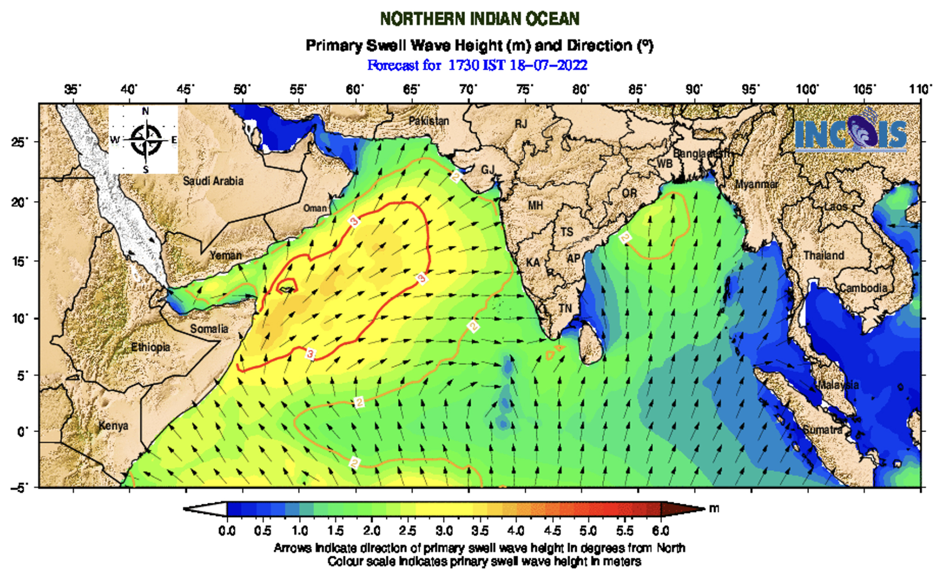
Figure 4Example of wave forecast produced by INCOIS.
INCOIS also provides operational wave forecasts through its integrated Indian Ocean Forecasting System (INDOFOS; https://incois.gov.in/portal/osf/osf_rimes/index.jsp, last access: 8 May 2025). These forecasts are essential for maritime safety, navigation, and various ocean-based activities. INCOIS utilizes the third-generation wind wave model WAVEWATCH III (Tolman, 2009) (Fig. 4).
4.2 Coastal systems
INCOIS ROMS-Coastal is the only coastal model identified for the Indian Seas. It has approximately 2.3 km spatial resolution, which is forced with the same NCUM atmospheric variables as in the case of ROMS and does not assimilate any data but takes initial and boundary conditions from the 9.2 km regional setup of ROMS. Data visualization and products are made available through a dedicated INCOIS web portal, available at https://incois.gov.in/portal/osf/osf.jsp (last access: 8 May 2025), and data are available to users on request.
The African Seas can be subdivided into six regions, based on distinct ecosystem characteristics: the Canary Current large marine ecosystem (LME), the Guinea Current LME, the Benguela Current LME, the Agulhas–Somali Current LME, the Red Sea LME and the Mediterranean Sea LME. Aside from the Mediterranean Sea LME, which will be discussed separately, an overview of the landscape with respect to operational ocean forecast services will be provided below. Operational ocean modeling is a developing field, with limited capacity in most parts of Africa. Operational services in these regions therefore depend largely on core global products and vary in levels of complexity, from disseminating locally relevant information via monthly bulletins to limited area forecast models that use global products at their boundaries. While various types of ocean forecast services exist to support national priorities, two consortia have been developed through Global Monitoring for Environment and Security (GMES; https://gmes.rmc.africa/, last access: 8 May 2025) and Africa to provide more regional support for marine and coastal operations. These are Marine and Coastal Operations for Southern Africa and the Indian Ocean (MarCOSIO; https://marcosio.org/, last access: 8 May 2025) and Marine and Coastal Areas Management in North and West Africa (MarCNoWA; https://geoportal.gmes.ug.edu.gh/#/, last access: 8 May 2025). These platforms currently make use of global services for Earth observations (EOs) as well as marine forecast products that in some cases are optimized for local conditions.
5.1 Regional systems
There are a limited number of regional forecast systems optimized specifically for African Seas.
-
The Iberia Biscay Irish Marine Forecasting Centre (IBI-MFC; https://marine.copernicus.eu/about/producers/ibi-mfc, last access: 8 May 2025) Ocean Physics, Waves and Biogeochemistry Analysis and Forecast products, provided by the Copernicus Marine Service, are suitable for use by regional services in north and northwest Africa.
-
The INCOIS project Hyderabad and the Regional Integrated Multi-Hazard Early-Warning System (RIMES; https://rimes.int/, last access: 8 May 2025) have developed an integrated high-resolution regional ocean forecasting system that encompasses the ocean regions of Madagascar, Mozambique, and the Seychelles.
-
The Integrated Red Sea Model (iREDS-M1) has been developed by the King Abdullah University of Science and Technology in Saudi Arabia. Its atmospheric and ocean (wave and general circulation) models are running on an operational basis to provide short-range forecasts for the Red Sea (Hoteit et al., 2021).
-
The South African Weather Service (SAWS; https://www.weathersa.co.za/; last access: 8 May 2025) provides regional wave, wave–current interaction and tide forecasts, downscaled from global services, none of which are assimilative (Barnes and Rautenbach, 2020). They also provide an empirically derived algorithm-based forecast of the sea ice edge for METAREA VII (de Vos et al., 2021).
-
The MarCNoWA focuses on delivering Earth observation (EO) services to coastal and marine environments and fisheries:
-
provision of potential fishing zone charts overlaid with vessel traffic,
-
monitoring and forecasting of oceanography variables,
-
forecast of ocean conditions,
-
oil spill monitoring,
-
generation of coastal vulnerability indices and mapping of coastal habitats.
Through a network of national stakeholders, regional fisheries and environmental bodies, academia, private sector, and researchers, the project is to impact decision making in the beneficiary countries. It downscales Copernicus Marine products and provides forecasts (Forecasts – Global Monitoring for Environment and Security & Africa, https://gmes.rmc.africa/, last access: 14 May 2025).
-
-
The forecasting system GCOAST (Geesthacht Coupled cOAstal model SysTem; https://www.hereon.de/institutes/coastal_systems_analysis_modeling/research/gcoast/, last access: 8 May 2025), developed by Hereon, is implemented at regional scale for the western coast of Africa. GCOAST (available at https://www.hereon.de/institutes/coastal_systems_analysis_modeling/research/gcoast/index.php.en, last access: 8 May 2025) is built upon a flexible and comprehensive coupled model system, integrating the most important key components of the regional and coastal systems and, additionally, allowing information from observations to be included. The operational modeling system is developed based on a downscaling approach from the Copernicus Marine GLO-MFC forecast products at ° resolution, focusing on the western African coast. The wind wave model is based on WAM (WAve Modeling). The atmospheric forcing is taken from ECMWF.
5.2 Coastal systems
Operational ocean forecast services for African coasts include the following:
-
The National Coastal Forecasting System for Mozambique (FEWS-INAM) provides 3 d ocean and meteorological forecasts in the form of daily bulletins and text messages to support operations at sea. It uses global NCEP GFS data to provide meteorological and wave boundaries and GLOSSIS (https://www.deltares.nl/en/expertise/projects/global-storm-surge-information-system-glossis, last access: 8 May 2025) for the storm surge boundary conditions. The forecasts include wave information, tide and surge water levels, and atmospheric weather information. This system was developed by a consortium, including Mozambique's Met Office INAM31, Deltares, UK Meteorological Office, and the DNGRH.
-
SAWS provides higher-resolution wave forecasts, optimized for key coastal regions as well as storm surge forecasts. The information is disseminated on their web portal (https://marine.weathersa.co.za/Forecasts_Home.html, last access: 14 May 2025)
-
The SOMISANA (A sustainable Ocean Modelling Initiative: a South African Approach, available at https://somisana.ac.za/, last access: 8 May 2025) has developed two limited-area downscaled bay-scale operational forecast systems for key areas around the South African coastline, which are (i) Algoa Bay and (ii) the southwest cape coast. The models run daily and provide 5 d forecasts of currents, temperature, and salinity through the water column (Fig. 5). The models are forced by the GFS atmospheric forecasts at the surface and by the Global Ocean Analysis and Forecast system provided by Copernicus Marine Service at the lateral boundaries. The model outputs can be explored at https://somisana.ac.za/. The validation reports are available for the two operational forecast models.
-
Coastal and fluvial flood forecasting has been developed in response to the extreme storm surge and flooding events on the KwaZulu-Natal coast of South Africa by Deltares and the local municipality (details available in the informative leaflet at https://publications.deltares.nl/EP4040.pdf, last access: 8 May 2025). The coastal (Delft3d) and fluvial (SWMM) models are run in forecast mode (Delft-FEWS) every 6 h and provide 3 d forecasts. As inputs, they use global forecast services from the ECMWF and the NCEP.
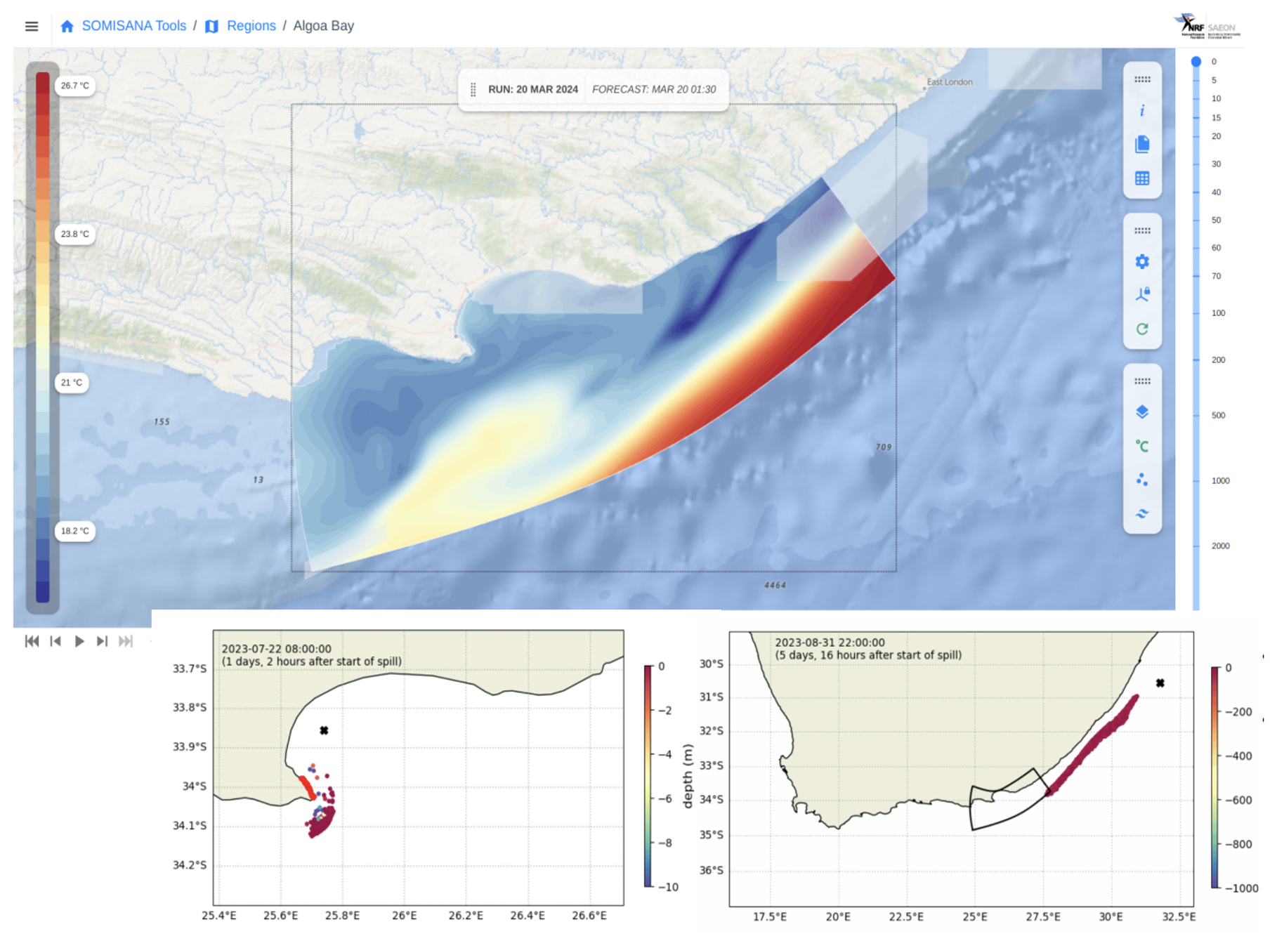
Figure 5The web portal of the bay-scale forecast system developed by the SOMISANA team in South Africa. The web portal allows users to explore the variables as well as scrutinizing various depth levels of the forecasts. The insets show the oil spill tracking functionality, developed using the OpenDrift software, that allows for the seamless integration of the global and regional, bay-scale forecasts in tracking the spill.
The coastal forecasting system developed in response to extreme storm surge, waves, and flooding events along the eastern coast of Ghana utilizes advanced modeling techniques and global forecast services. The coastal model employed in this system is a flexible and modular modeling platform GCOAST for regional and coastal applications. The hydrodynamical model is based on SCHISM (Semi-implicit Cross-scale Hydroscience Integrated System Model; https://ccrm.vims.edu/schismweb/, last access: 8 May 2025), which is coupled with the wind wave model (WWM). The coastal forecasting modeling platform ensures a flexible grid for the eastern coast of Ghana, with a resolution ranging from 50 m in the estuaries up to 1 km. The system is designed to provide both hindcasts and forecasts. For hindcast simulations, it uses the GLORYS12 reanalysis (Global Ocean Physics Reanalysis, product ID: GLOBAL_REANALYSIS_PHY_001_030; available at https://data.marine.copernicus.eu/product/GLOBAL_MULTIYEAR_PHY_001_030/description, last access: 8 May 2025). For forecasts, it uses the GLO-MFC (product ID: GLOBAL_ANALYSIS_FORECAST_PHY_001_024). Atmospheric forcing is provided by the ECMWF operational forecast products. At the boundaries, the model is coupled to the Global Ocean Physics Reanalysis GLORYS12 provided by the Copernicus Marine Service (as part of the GLO-MFC product catalogue) and produced by Mercator Ocean International. The coastal forecasting system incorporates tidal forcing from the Finite Element Solution 2014 (FES2014; Lyard et al., 2021) global ocean tide model, which provides tidal elevations and currents on a ° grid and has demonstrated significant improvements over previous versions, particularly in coastal and shelf regions. This comprehensive approach ensures that stakeholders receive timely and accurate information to prepare and respond effectively to extreme events along the eastern coast of Ghana. In addition to its predictive capability, the system also supports environmental resilience. It integrates mangrove vegetation into the modeling platform to assess and promote nature-based solutions for coastal protection. This component enables the evaluation of scenarios in which mangrove cover is varied to estimate its potential to mitigate wave energy and reduce coastal erosion. The implementation builds on the findings of recent studies demonstrating the buffering role of mangroves against hydrodynamic forces in the coast of Ghana, contributing to sustainable coastal management strategies. These insights guide the design of adaptive coastal management strategies based on nature-based interventions (Jayson-Quashigah et al., 2025).
The beginning of the 21st century can be considered the starting point of the Mediterranean and Black Sea's operational forecasting services thanks to the favorable conjunction of several aspects:
-
A general concept of operational oceanography was emerging worldwide.
-
The advent of new ocean monitoring technologies allowed for multiplatform systems, including both in situ monitoring and satellite remote sensing, that in addition to the development of internet network connections started providing open data with a near-real-time availability (Tintorè et al., 2019).
-
The development of numerical modeling and prediction systems gave rise to the release of the first ocean forecast of the Mediterranean Forecasting System (MFS) in 2000, which provided regular and freely available 10 d predictions of the Mediterranean Sea dynamics with a spatial resolution of 7 km (Pinardi et al., 2003).
-
The first Black Sea nowcasting and forecasting systems, developed during the first decade of 2000, were implemented in the framework of the ARENA (http://old.ims.metu.edu.tr/black_sea_goos/projects/arena.htm, last access: 8 May 2025) and of the EU FP6 ECOOP (European COastalshelf sea OPerational observing and forecasting system) projects.
-
The Mediterranean scientific community started to get organized to establish a Mediterranean Operational Oceanography Network (MOON), which in 2012 became the Mediterranean Operational Network for the Global Ocean Observing System (MonGOOS; https://mongoos.eurogoos.eu/, last access: 8 May 2025). Also, the Black Sea Community, within the Global Ocean Observing System, has been established into the Black Sea GOOS (https://eurogoos.eu/black-sea/, last access: 8 May 2025).
In the following, some details on the services implemented in the Mediterranean and Black Sea are provided at regional scale, for the whole basins, and at coastal scale (here the global services are not considered since these basins have strongly regional dynamics and maintain a connection to the global ocean through the narrow Strait of Gibraltar, in the case of the Mediterranean Sea, therefore, this section will only consider regional and coastal services).
6.1 Regional systems
There are a limited number of regional forecast systems optimized specifically for African Seas.
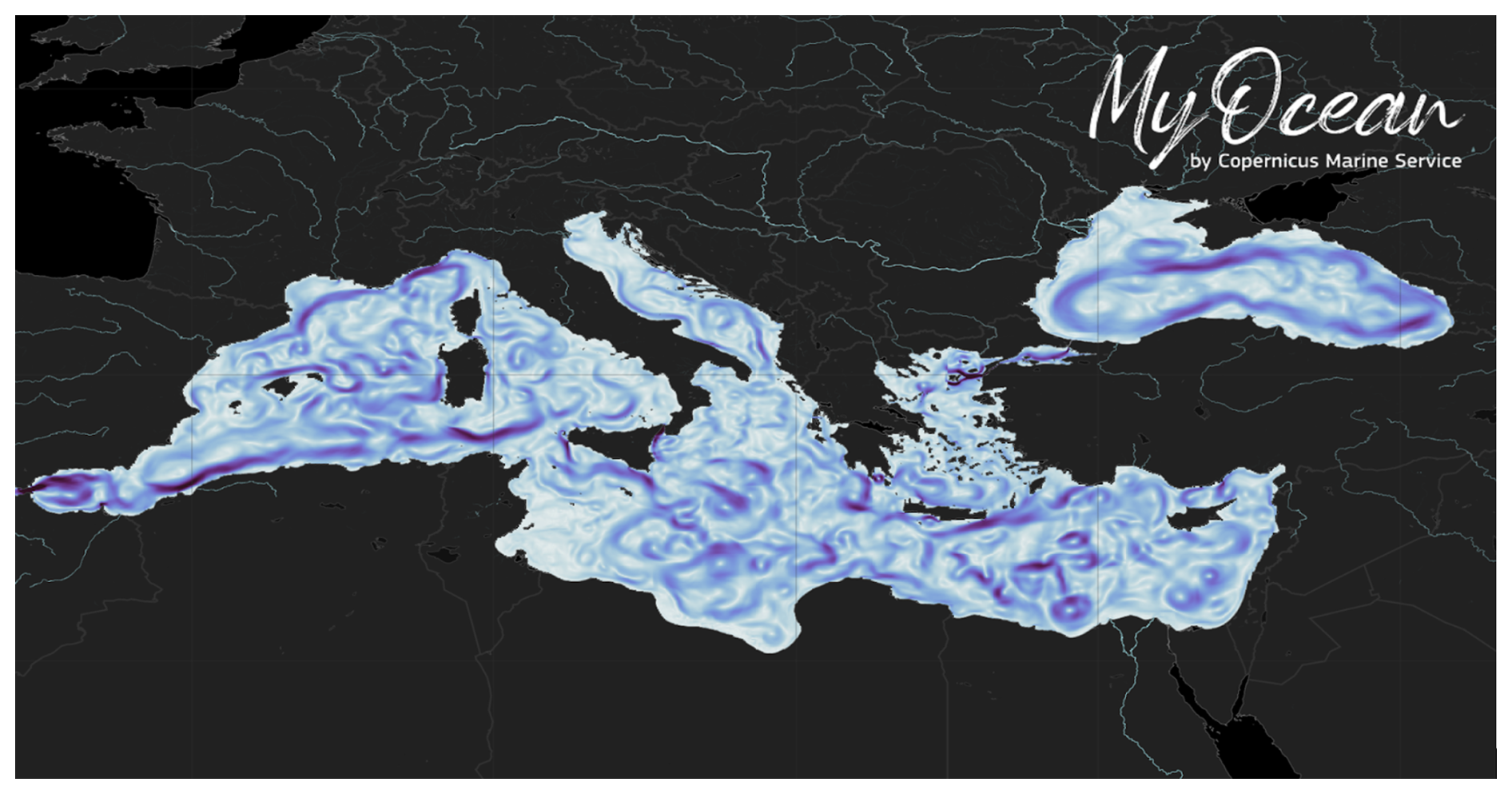
Figure 6Mediterranean and Black Sea Forecasting Systems sea surface currents visualization as provided by the Copernicus Marine Service.
During the last decades, major developments have been undertaken to improve the operational forecasting systems of the Mediterranean and Black Sea, first in a pre-operational phase within MyOcean EU projects leading to the Copernicus Marine Service since 2015. The Mediterranean (Med-MFC; Coppini et al., 2023) and the Black Sea (BS-MFC; Ciliberti et al., 2022) Monitoring and Forecasting Centers can be considered the core services for these regions (Fig. 6).
They provide, every day, 10 d forecast fields at around 4 and 2.5 km resolution, in the Mediterranean and Black Sea respectively, for the whole set of Essential Ocean Variables, including currents, temperature, salinity, mixed layer thickness, sea level, wind waves, and biogeochemistry, which are freely available to any user (scientists, policymakers, entrepreneurs, and ordinary citizens, from all over the world) though the Copernicus Marine Data Store. To support users, tailored services and training, adapted to different levels of expertise and familiarity with ocean data, are also provided.
Three operational systems compose both the Med-MFC and the BS-MFC: the physical component, which is based on the NEMO (Gurvan et al., 2022) ocean general circulation model (OGCM); the wave component, which is based on the third-generation spectral model, WAM (The Wamdi Group, 1988); and the biogeochemical component, which is based on the Biogeochemical Flux Model (BFM; Vichi et al., 2020) and on BAMHBI (Grégoire et al., 2008; Capet et al., 2016) for the Mediterranean and Black Sea, respectively. The systems assimilate in situ and satellite data, including sea level anomalies, along-track altimetry data, significant wave height, sea surface temperature, and chlorophyll-a concentration, provided by the corresponding Copernicus Marine Thematic Assembly Centers, and are jointly and constantly improved following users' needs. These Mediterranean and Black Sea core services, by providing accurate boundary conditions in a timely manner, enable the implementation of higher-resolution and relocatable forecasting systems in different areas and support the development of many downstream applications and services.
In addition to the abovementioned core services, other forecasting systems are implemented at regional scale such as the following:
-
A high-resolution Mediterranean and Black Sea system based on the MITGCM (Massachusetts Institute of Technology General Circulation Model; Marshall et al., 1997) described in Palma et al. (2020). The system includes tides, is resolved at a 2 km resolution (and higher resolution in specific areas), and is nested in the Med-MFC. This system has been used as a basis to develop a ° model to assess present and future climate in the Mediterranean Sea focusing on sea level change – MED16 (Sannino et al., 2022).
-
The KASSANDRA (http://kassandra.ve.ismar.cnr.it:8080/kassandra, last access: 8 May 2025) storm surge forecasting system for the Mediterranean and Black Sea is based on the coupled hydrodynamic SHYFEM (Umgiesser et al., 2004) and wave (WAVEWATCH III) models, allowing for very high resolution in specific areas (Ferrarin et al., 2013).
-
The MFS (Mediterranean Forecasting System; https://medforecast.bo.ingv.it/, last access: 8 May 2025) is developed at INGV (National Institute of Geophysics and Volcanology, Italy) with ° resolution and is based on NEMO and implementing a 3D variational data assimilation scheme (OceanVar; Dobricic and Pinardi, 2008).
-
The physical and wave ocean system MITO (Napolitano et al., 2022) provides 5 d forecasts of the Mediterranean Sea circulation based on the MITGCM and is forced by the Copernicus Mediterranean physical and wave forecasting products to generate 5 d forecasts data at a horizontal resolution up to ° degree.
-
The POSEIDON (https://www.poseidon.hcmr.gr, last access: 8 May 2025) basin-scale Mediterranean forecasting system (∼ 10 km resolution) ocean and ecosystem state is developed at HCMR (Hellenic Centre for Marine Research, Greece). This includes a hydrodynamic model, based on POM (Blumberg and Mellor, 1987), which assimilates satellite and in situ data (Korres et al., 2007), and a biogeochemical model, based on ERSEM (European Regional Seas Ecosystem Model; Baretta et al., 1995; Kalaroni et al., 2020a, b).
-
The CYCOFOS wave forecasting system provides 5 d forecasts of the Mediterranean and the Black Sea (Zodiatis et al., 2008) based on WAM and is forced by the SKIRON high-frequency winds.
6.2 Coastal systems
Several coastal systems are developed and implemented in the Mediterranean and Black Sea, not only for operational uses but also for research purposes by a wide research community. These modeling systems generally make use of community models that are widely used by the scientific community for a diverse range of applications including the hydrodynamical, waves and biogeochemical marine components. In the following, several of them are illustrated, providing main information and references for more details.
6.2.1 Hydrodynamics
-
The IBI-MFC Physics Analysis and Forecasting System (https://data.marine.copernicus.eu/product/IBI_ANALYSISFORECAST_PHY_005_001/description, last access: 8 May 2025) provides operational analysis and forecasting data at ° resolution, implementing the NEMO model integrated with a data assimilation scheme SAM2, which allows for a multivariate assimilation of sea surface temperature together with all available satellite sea level anomalies and in situ observations.
-
The Sistema de Apoyo Meteorológico y Oceanográfico de la Autoridad Portuaria (SAMOA; Álvarez Fanjul et al., 2018; Sotillo et al., 2019; García-León et al., 2022) provides operational downstream services and a significant number of high-resolution forecasting applications, based on Copernicus Marine forecasting services and the Spanish Meteorological Agency (for atmospheric forecast), including 20 atmospheric models, 21 wave models, and 31 circulation models. ROMS (Regional Ocean Modeling System) is implemented at a resolution of 350 to 70 m.
-
The WMOP model (Juza et al., 2016; Mourre et al., 2018) based on ROMS is a downscaling of the Copernicus Mediterranean system, with a spatial resolution of 2 km and covering the western Mediterranean basin from the Strait of Gibraltar to the longitude of the Sardinia Channel. It is implemented by SOCIB (Balearic Islands Coastal Observing and Forecasting System) and is run operationally on a daily basis, producing 72 h forecasts of ocean temperature, salinity, sea level, and currents.
-
A high-resolution numerical model, developed as part of an operational oceanography system in the frame of the Sistema Autonomo de Medicion, Prediccion y Alerta en la Bahia de Algecira (SAMPA) project is implemented by Puertos Del Estado (Spain), providing operational ocean forecast data in the complex dynamical areas of the Strait of Gibraltar and the Alboran Sea.
-
The MARC (Modelling and Analyses for Coastal Research) and ILICO (Coastal Ocean and Nearshore Observation Research Infrastructure) are implemented using the MARS3 model in the Bay of Biscay–English Channel–northwestern Mediterranean Sea at 2.5 km horizontal resolution and nested in the Copernicus Marine global system.
-
The Tyrrhenian and Sicily Channel Regional Model (TSCRM; Di Maio et al., 2016; Sorgente et al., 2016) is based on a regional implementation of POM at 2 km resolution and is nested into the Copernicus Mediterranean Analysis and Forecasting system.
-
The Southern Adriatic Northern Ionian coastal Forecasting System (SANIFS; Federico et al., 2017) is a coastal-ocean operational system based on the unstructured-grid finite-element 3D hydrodynamic SHYFEM model reaching a resolution of a few meters. It is a downscaled version of the Med-MFC physical product and provides short term forecast fields.
-
The Aegean and Levantine eddy-resolving model (ALERMO; Korres and Lascaratos, 2003) is based on POM implemented at ° resolution and nested into the Copernicus Mediterranean Analysis and Forecasting system.
-
The Cyprus Coastal Ocean Forecasting and Observing System (CYCOFOS; Zodiatis et al., 2003, 2018) is specifically developed to provide a sub-regional forecasting and observing system in the eastern Mediterranean (including the Levantine Basin and the Aegean Sea). The latest system is forced by the Copernicus Med-MFC physical forecasting system and implements POM at 2 km resolution to produce initial and open boundary conditions in specific locations.
-
The TIRESIAS Adriatic forecasting system is based on the unstructured grid 3D hydrodynamic model SHYFEM and represents the whole Adriatic Sea together with the lagoons of Marano–Grado, Venice, and the Po Delta (Ferrarin et al., 2019). It is a downscaled version of the Med-MFC physical product and provides 3 d forecast fields.
6.2.2 Waves
-
The IBI-MFC Waves Analysis and Forecasting system (Toledano et al., 2022) is based on MF-WAM (Meteo-France WAM). It is implemented at ° resolution and produces wave forecasts in the western part of the Mediterranean Sea twice a day.
-
The SAPO (Autonomous Wave Forecast System; https://static.puertos.es/pred_simplificada/Sapo/d.corunia/sapoeng.html, last access: 8 May 2025) based on WAM is implemented at several Spanish ports with a 72 h forecast horizon, and it is nested within the PORTUS forecast system, an operational wave forecast for Spanish Port Authorities.
-
The WAMADR setup of ECMWF WAM is implemented by the Slovenian Environment Agency for the Adriatic and central Mediterranean domain with a horizontal resolution of 72 h and a spatial resolution of 1.6 km. The model is forced by a hybrid ALADIN SI and ECMWF surface wind product and runs daily.
-
Several coastal and local wave applications providing wave information near the harbors, as well as boundary conditions for specific wave agitation inside the port applications, use the SWAN model (Booij et al., 1999).
6.2.3 Biogeochemistry
-
The IBI-MFC Biogeochemical Analysis and Forecasting System (https://data.marine.copernicus.eu/product/IBI_ANALYSISFORECAST_BGC_005_004/description, last access: 8 May 2025) is implemented using the PISCES (Aumont et al., 2015) model at ° horizontal resolution.
-
The Northern Adriatic Reanalysis and Forecasting system (NARF) and the CADEAU physical-biogeochemical reanalysis (Bruschi et al., 2021) implement the MITgcm–BFM coupled models in the Northern Adriatic Sea, reaching up to 750 m with a further high resolution (∼ 125 m) and nesting in the Gulf of Trieste (https://medeaf.ogs.it/got; last access: 8 May 2025).
Operational oceanography in European countries was mainly operated at a national level until the 1990s. In 1994, the European part of the Global Ocean Observing System (EuroGOOS, https://eurogoos.eu/, last access: 8 May 2025) was founded. It grouped these national endeavors into a network of European monitoring and forecasting systems and initiated several regional and thematic working groups to support specific developments. Since the early 1990s, the European Commission has been actively funding programs to support ocean monitoring and forecasting through, for instance, its series of MyOcean projects (2009–2015) and its ongoing ambitious Copernicus Earth observation program, which includes the Copernicus Marine Service component.
Due notably to the coordinating efforts provided by the Copernicus Marine Service over the last decade, the North East Atlantic region is now well equipped in terms of operational marine forecasting services. Also, each segment of the North East Atlantic coastline is included in at least one regional system, such that global forecast services are seldom used directly, except for the provision of boundary conditions to downstream forecast systems. An inventory of operational marine and coastal models around Europe was compiled out of a survey conducted in 2018–2019 among members of EuroGOOS and its related network of regional operational oceanographic systems (Capet et al., 2020), addressing the purposes, context, and technical specificities of operational ocean forecast systems (OOFSs). Here, we re-focus this analysis on the North East Atlantic by excluding the Arctic, Mediterranean, and Black Sea basins from the original analysis. It should be noted that this inventory only includes OOFSs actively reported to the survey and might therefore be incomplete. A further expansion of the North East Atlantic OOFS inventory is expected from the OceanPrediction DCC Atlas.
Besides the three Copernicus Marine regional forecast services, the inventory includes 35 other regional OOFSs and 32 coastal OOFSs, arbitrarily identified as systems with a spatial resolution below 3 km and a longitudinal and latitudinal domain extent below 5°.
7.1 Regional systems in the framework of the Copernicus Marine Service
The major marine core service for the North East Atlantic is provided by the Copernicus Marine Service and its three regional Monitoring Forecasting Centres (MFCs) dedicated to the Iberian, Biscay, and Irish seas (IBI-MFC); European Northwestern Shelves (NWS-MFC; https://marine.copernicus.eu/about/producers/nws-mfc, last access: 8 May 2025); and Baltic Sea (BAL-MFC; https://marine.copernicus.eu/about/producers/bal-mfc, last access: 8 May 2025), respectively (Fig. 7).
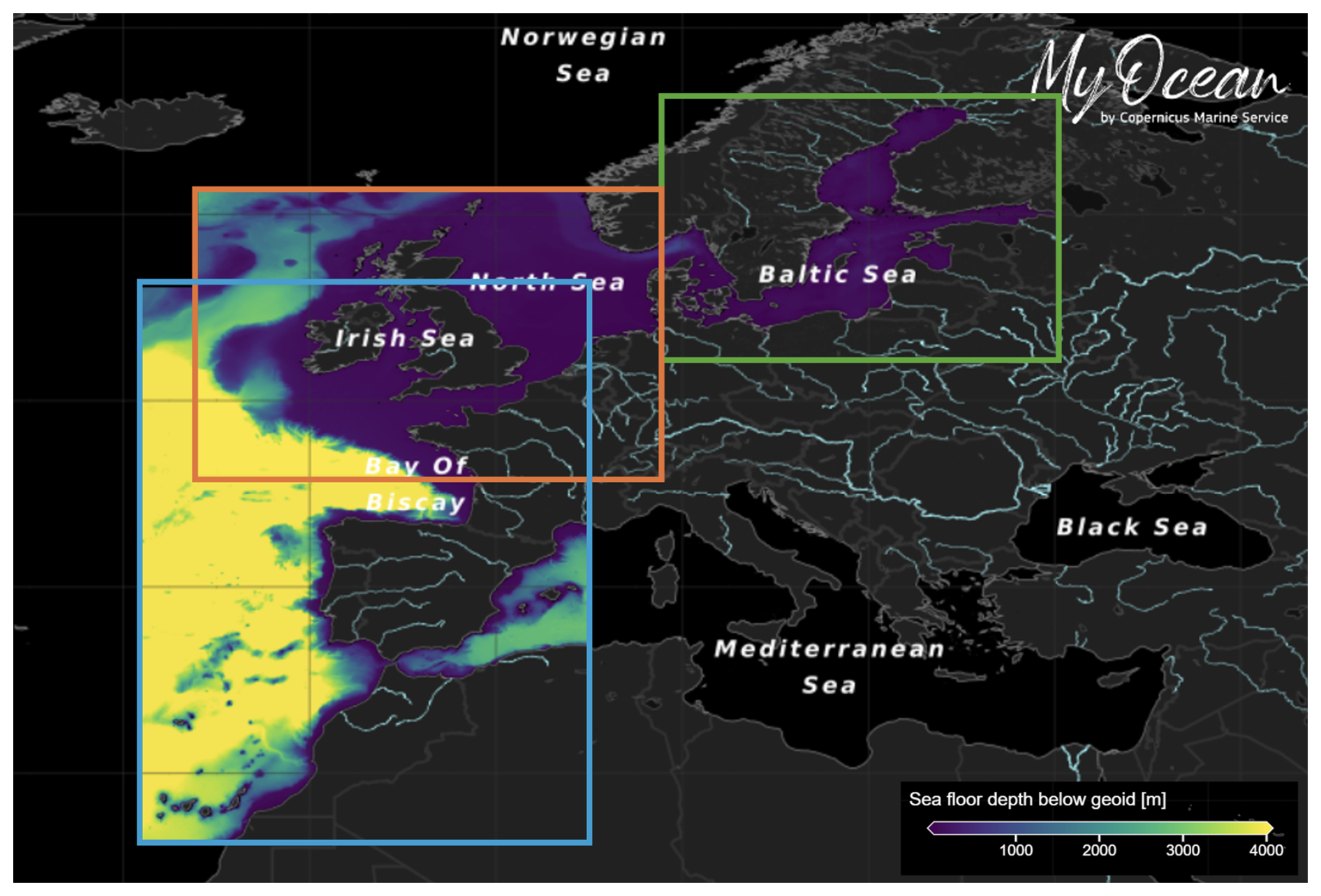
Figure 7The Copernicus Marine regional monitoring and forecasting centers operating in the area: IBI-MFC (in blue), NWS-MFC (in orange), and BAL-MFC (in green). The map shows bathymetry (m) and the composite regions obtained from the MyOcean Viewer (https://marine.copernicus.eu/access-data/ocean-visualisation-tools, last access: 14 May 2025).
In terms of modeling, each of these three MFCs is composed of dedicated components addressing ocean circulation (PHY), biogeochemistry (BGC), and wave dynamics (WAV). These systems operate under the coordinated umbrella of Copernicus Marine Service and therefore benefit from homogenized protocols in terms of operational data production, validation, documentation, and distribution (Le Traon et al., 2019). Products and related documentation can be accessed through the central Copernicus Marine Data Store, together with observational datasets including in situ, remote sensing, and composite products for the Blue (physics and hydrodynamics), Green (biochemistry and biology), and White (sea ice) ocean. Operational data delivery is provided through online data selection tools and a variety of automatic protocols (e.g., Subset, FTP, WMTS), which effectively enables a number of operational downstream services to depend directly on those core services. A catalogue of such downstream usage and its potentialities is exposed on the Copernicus Marine Use Cases portal (https://marine.copernicus.eu/services/use-cases, last access: 8 May 2025).
7.2 Other regional systems
The 35 regional forecasts systems that are not operated by Copernicus Marine are mostly operated by national entities and provide data free of charge to relevant users in 71 % of the cases. They address circulation (80 % of the regional OOFSs), wave dynamics (23 %), and biogeochemistry (14 %), as well as Lagrangian drift dynamics, for the sake of oil spills and search and rescue services. Of these 35 systems, 12 report a dependence on the Copernicus Marine products (including GLO-MFC forecast products) in terms of open-sea boundary conditions. Many of these systems (10) benefit from the SMHI e-Hype products to constrain river discharge. Regarding atmospheric conditions, the majority (22 regional OOFSs) rely on Pan-European products (typically provided by ECMWF), but regional atmospheric products are also exploited, as qualitative operational products are provided by national agencies in most European countries.
7.3 Coastal systems
A total of 32 coastal OOFSs are reported in the EuroGOOS Coastal Working Group (CWG) inventory for the North Sea, Baltic Sea, and European shelves, addressing circulation (68 % of the coastal OOFSs), biogeochemistry (29 %), and wave dynamics (4 %). Again, these OOFSs are mostly operated by public entities (although this is recognized as a potential bias in the survey, as discussed in Capet et al., 2020) and provide, in the vast majority of cases, forecast data that are freely accessible to relevant users.
Among coastal OOFSs, the usage of land and atmospheric forcing data from specific national sources is much more common than for regional systems, indicating that adequate products are available at local scales. Besides, several coastal system operators rely on their own atmospheric or hydrology model to obtain adequate boundary conditions. One could highlight that 15 of the 35 reporting coastal OOFSs provide forecasts at a spatial resolution below 500 m, at least in some parts of their domain. In general, such systems also consider fine bathymetry, with a minimal water depth of under 5 m (Fig. 8).
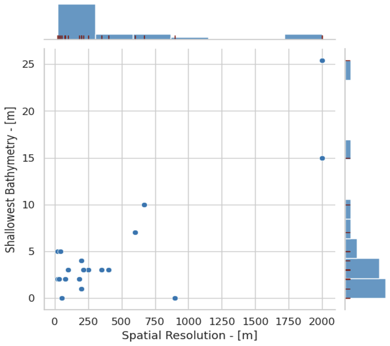
Figure 8Joint and marginal distribution of the minimal water depth and spatial grid resolution, for all North East Atlantic coastal model domains illustrated in Fig. 7.
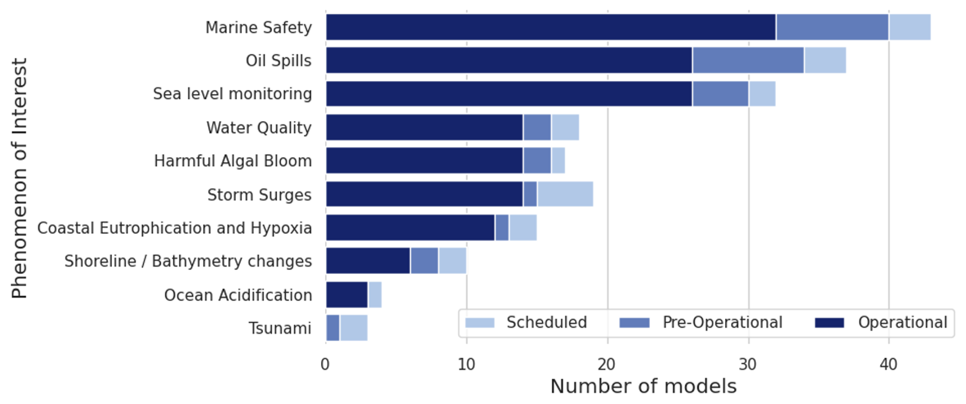
Figure 9Number of regional and coastal models considered by their providers to be relevant for a proposed set of downstream sectorial applications and phenomenon of interest. Based on the 2018–2019 EuroGOOS CWG survey (Capet et al., 2020).
According to the survey, which was in almost all cases answered by model operators, OOFSs in the North East Atlantic are relevant for marine safety, oil spills, and sea level monitoring concerns (Fig. 9). However, the survey did not consider the extent to which provided information was effectively exploited by downstream operators. To a lesser extent, some systems address biochemical issues such as water quality, harmful algal blooms, or coastal eutrophication.
The development of short-range ocean forecasting systems in South and Central America is relatively recent with respect to other systems in Europe, North America and East Asia. They are very heterogeneous, reflecting their different needs, local observational systems, and infrastructure. Operational systems are present today in Argentina, Brazil, Chile, Colombia, Panama, and Peru, with a focus on regional- and basin-scale domains in the western Pacific, South Atlantic, and the Caribbean Sea and on tackling forecasts on short-term to seasonal timescales. All of them are rapidly evolving considering the outstanding scientific and technical knowledge gained by the oceanographic global community and the permanent increase in computational resources. Some details about some of these systems are presented below.
8.1 Regional systems
In Brazil, a few regional (and coastal) forecast systems exist, considering the vast oceanic area under Brazilian jurisdiction (branded as Blue Amazon), which currently total 4.4×10⁶ km2, approximately half of the Brazilian terrestrial area, with the possibility of reaching 5.7×10⁶ km2 in the future (Franz et al., 2021). The forecasting service results are not available for the public in general due to restrictions imposed by public–private partnerships and other constraints.
The first operational ocean forecast system with data assimilation in Brazil was implemented in the Brazilian Navy Hydrographic Center in 2010 based on the Hybrid Coordinate Ocean Model (CHM-HYCOM) and on an optimal interpolation scheme, developed by the Oceanographic Modeling and Observation Network (REMO) (Lima et al., 2013). Since 2014, CHM-HYCOM forecasts have been initialized by the REMO Ocean Data Assimilation System (RODAS) (Augusto Souza Tanajura et al., 2014; Tanajura et al., 2020), based on the optimal interpolation scheme, which can assimilate SST analysis, along-track or gridded sea level anomalies (SLAs), and T–S vertical profiles. The ensemble members are chosen according to the assimilation day from a previous free run. The most recent CHM-HYCOM + RODAS configuration produces 5 d forecasts daily and encompasses the entire North, equatorial, and South Atlantic with ° horizontal resolution, to generate boundary conditions for a regional domain grid covering the METAREA-V (35.8° S–7° N, 20° W) with a horizontal resolution of °, both with 32 vertical hybrid layers. Other models are also employed operationally in CHM. ADCIRC is employed in Guanabara Bay, São Sebastião and Ilha Bela proximities, and Sepetiba Bay, as well as in Santos and Paranaguá ports.
Regarding the Argentine Sea, the Modelling System for the Argentine Sea (MSAS) is used to model the barotropic component of the ocean state of the southwestern Atlantic continental shelf. MSAS is based on the Coastal and Regional Ocean Community Model (CROCO; http://www.croco-ocean.org, last access: 8 May 2025). Dinápoli et al. (2023) modified the source code to resolve the depth-averaged horizontal momentum and continuity equations, as well as consider spatially varying bottom friction. MSAS covers the Southwestern Atlantic Continental Shelf with a trapezoidal shape designed to avoid a significant number of land points and ensure the regular spatial resolution of 8 km in both directions. Along the boundaries, the model is forced with tides and continental discharges, whereas in the interior of the domain, the ocean surface is forced by atmospheric pressure and surface wind stress (Dinápoli et al., 2020a, 2021, 2023). In addition, MSAS has been used to conduct several scientific studies on the barotropic nonlinear interactions in the region (Dinápoli et al., 2020b), the tidal resonance over the continental shelf (Dinápoli and Simionato, 2024), and the genesis and dynamics of the storm surges along the coast (Alonso et al., 2024; Dinapoli and Simionato, 2025; Dinapoli et al., 2024). Recently, the Asynchronous Ensemble Square Root Filter (4DEnSRF; Sakov et al., 2010; Whitaker and Hamill, 2002) DA scheme was also incorporated as part of MSAS. The 4DEnSRF scheme is currently used to produce optimal initial conditions for the forecasts by assimilating tidal gauges and remote sensing observations. Because of the large and nonlinear impact of the wind uncertainty on the regional barotropic dynamics (Dinápoli et al., 2020a), an ensemble wind forecast is used. Dinápoli et al. (2023) used the 31-member ensemble from NCEP's Global Ensemble Forecast System, together with a set of perturbations of the tides. Since the atmospheric ensemble provides the wind field, rather than the wind stress, the former is estimated using the parameterization of Simionato et al. (2006). The incorporation of 4DEnSRF into MSAS forecasts, together with an ensemble post-processing technique developed by Dinápoli and Simionato (2022), has improved the 96 h forecasts by reducing the model bias and correcting the timing of the strong storm surges that affect the northern part of the Southwestern Atlantic Continental Shelf. It is important to mention that MSAS is running pre-operatively, and its solutions will be made public in the future. Relevant developments have been achieved with regard to wind wave modeling. The numerical model WAVEWATCH III was regionalized and validated with direct observations from a number of buoys scattered in the Southwestern Atlantic Continental Shelf.
In Peru, a large effort in climate modeling has been undertaken in the 2000s so far to develop sub-seasonal forecasts and anticipate the significant socio-economic consequences of the El Niño–Southern Oscillation (ENSO). The Geophysical Institute of Peru (IGP) has recently implemented a regional Earth system model in forecast mode called IGP RESM-COW v1. This system released in December 2023 (Montes et al., 2023) is based on CROCO (Debreu et al., 2012) coupled to the WRF atmospheric model through the OASIS coupler (Craig et al., 2017) and now serves as an additional forecasting tool for establishing the recommendations by the ENFEN (Estudio Nacional del Fenómeno El Niño), a governmental body responsible for monitoring, studying, and predicting the El Niño phenomenon and its impacts on the country. The IGP RESM-COW v1 has a horizontal resolution of 12 km for the ocean component and 30 km for the atmospheric component. The domain covers the entire Peruvian territory and part of the eastern Pacific. The current implementation takes as input the forecasts of the NOAA CFSv2 global climate model that have been corrected using a combination of reanalysis data (GLORYS outputs and the NCEP Final Analysis (FNL) data) and the climatological averages of the NCEP coupled forecast system model version 2 (CFSv2) and of a 22-year-long simulation of the IGP RESM-COW v1 model. This allows forecasts of oceanic and atmospheric conditions to be made up to 7 months in advance (Segura et al., 2023). In addition, the Navy of Peru via the Dirección de Hidrografía y Navegación (Dihidronav) implemented the WAVEWATCH III for representing the wave behavior at the northern, central and southern off Peru with a prediction up to 5 d (https://www.naylamp.dhn.mil.pe/dhn2/secciones/Pronosticos/pronosticosolas/Peru_Olas.php, last access: 8 May 2025). This product is available for the scientific community and the public interested in understanding wave conditions (https://cpps-int.org/index.php/wave-watch, last access: 8 May 2025). Operation systems are also under development at IMARPE (Instituto del Mar del Peru, https://www.gob.pe/imarpe, last access: 8 May 2025) based on the CROCO system, which targets the aquaculture industry in the central Peru region (Arellano et al., 2023). IMARPE and IGP also produce forecasts of ocean conditions at regional scale (Equatorial Kelvin wave amplitude in the Eastern equatorial Pacific) at sub-seasonal timescales based on shallow water models (Mosquera-Vasquez et al., 2014).
As part of a 10-year-long national program (CLAP), CEAZA (Center for Advanced Studies in Aride Zones) is also currently developing an operational forecast system for the Coquimbo region (central Chile) based on CROCO initialized by Mercator forecasts in order to inform the fishery industry and the public. The 7 d lead time forecasts are to be provided through a mobile app (https://app.ceaza.cl/, last access: 14 May 2025) along with real-time observations (temperature, oxygen) from a buoy at Tongoy bay, a hot spot for the scallop aquaculture industry. The system is based on a CROCO configuration at 3 km resolution (Astudillo et al., 2019) and is coupled to a simple biogeochemical model (BioEBUS) that has been tuned and validated for the western coast of South America (Montes et al., 2014; Pizarro-Koth et al., 2019).
In Colombia, the Marine Meteorological Service (SMM; in Spanish), hosted by the Dirección General Marítima (DIMAR) as part of the Ministry of Defense, has co-developed the Integrated Forecast System for Comprehensive Maritime Security (SIPSEM; in Spanish; Urbano-Latorre et al., 2023) over the last 8 years. SIPSEM is an ecosystem of climate services (Goddard et al., 2020) for met-oceanographic applications, providing a suite of demand-driven and actionable information to ensure maritime safety and protect life at sea, while contributing to international regulations in the SOLAS, SAR, IALA, PIANC, IMO, and WMO conventions. Focusing on the ocean component, SIPSEM uses CROCO involving different domains and nests, tailored for the different applications and coastal complexities. Application on a regional scale in the Colombian Caribbean and Pacific employs a horizontal resolution equal to 9.16 km. Different CROCO forecast systems are nested in global forecasts produced by HYCOM + NCODA, Copernicus Global Ocean Physics Analysis and Forecast, and the US Global Navy Coastal Ocean Model. They are forced with the Weather and Research Forecast Model (WRF) with 27 km of horizontal resolution nested in GFS forecasts. For wind-generated wave prediction, daily WAVEWATCH III (Tolman et al., 2002) forecasts are used for local and regional areas with 3.7 and 18.5 km and are periodically calibrated by fine-tuning various model parameters to best represent the local observations. SWAN (Booij et al., 1999) is also used in nearshore and ports applications. Some key SIPSEM forecasts are publicly available via a web portal, available at https://meteorologia.dimar.mil.co/ (last access: 8 May 2025), developed targeting the general user.
8.2 Coastal systems
Regional to coastal operational models for the Brazilian Coast started to be developed in 2018 by the Centre for Marine Studies (CEM), from the Federal University of Paraná (UFPR), in collaboration with MARETEC, a research center of the Instituto Superior Técnico (IST – Universidade de Lisboa) from Portugal, through the application of the MOHID modeling system. This initiative, called Brazilian Sea Observatory (BSO), was initially supported by the User Uptake program from Copernicus Marine Service. In order to deliver high-resolution forecasts of the Brazilian coast, an operational modeling system was developed based on a downscaling approach from the GLO-MFC physical analysis and forecast system at ° resolution, focusing on the southeastern Brazilian shelf, including estuarine systems with important port activities and large environmental protection areas. Nowadays, the operational modeling system includes a model covering the southeastern Brazilian shelf with a horizontal resolution of °; a model covering the coasts and adjacent shelf of the states of Santa Catarina, Paraná, and São Paulo with a horizontal resolution of °; and high-resolution models (∼ 120 m) for coastal systems (Florianópolis bays, Babitonga Bay, and Paranaguá Estuarine Complex). The system is maintained by CEM/UFPR. Furthermore, an operational model was developed for the north of Brazil, encompassing the states of Amapá, Pará, and Maranhão and the Amazon River and Pará River estuaries, with a horizontal resolution ranging from to °. The atmospheric forcing comes from the WRF model implemented by the Brazilian National Institute for Space Research (INPE) with 7 km of horizontal resolution. The operational models have a vertical discretization reaching about 1 m of resolution near the surface.
In Chile, efforts to implement operational forecasting systems were initially led by the Navy, with a focus on swell forecasting for the entire Chilean coast or some key sites. These efforts have recently diversified to address issues around marine resource management (industrial and artisanal fisheries, aquaculture) and extreme event prediction. They are mostly based on the use of the CROCO WRF models. As part of the University of Concepción, COPAS Coastal Center is currently developing a forecast coupled system (CDOM-Portuario) based on WRF (https://www.mmm.ucar.edu/models/wrf, last access: 8 May 2025), WAVEWATCH III, SWAN, and CROCO to deliver 3 to 6 d forecasts of oceanic and weather conditions in the harbors of Coronel (378° S), Arica (17.5° S), and Antofagasta (21.5° S). The system is currently delivering operational products at 1 km resolution in uncoupled mode (offline). It targets a resolution of 300 m in fully coupled mode. The national Fisheries Development Institute (IFOP) has recently developed an operational system called CHONOS-MOSA for the south part of central Chile (Reche et al., 2021), focused on the inland seas of the Los Lagos and Aysén regions. It provides forecasts at a 3 d lead time based on CROCO at 1.2 km. The atmospheric forcing is derived from a forecast run based on WRF at 3 km with open boundary conditions from the Global Forecast System (NCEP GFS). Ocean boundary conditions are from GLO-MFC physical forecast products, and river run-offs from 35 point sources are used based on the FLOW products. Forecasts are provided online at https://chonos.ifop.cl/ (last access: 20 May 2024).
Besides these initiatives funded by the academic and public sectors, there are some private companies that also provide ocean and atmospheric forecasting for port operations in Chile. Siprol SpA provides wave, wind, and wave forecasts. They also provide wave forecasting for Ecuador. Also, the company PRDW provides the Automated Wave Forecast System (AWFOS), with 3 h to 10 d forecasting using a mathematical model coupled with a global wave model wave for deep waters. PRDW also provides forecasting for various sites in South American countries. Finally, the port of San Antonio, the first port in Chile in terms of port operations, is using models from the Direction of Port Construction (Dirección Obras Portuarias) in collaboration with the National Institute of Hydraulic of Chile (https://www.dop.pelcam.io/about, last access: 14 May 2025). The wind forecasting is provided by the San Antonio Port Company (EPSA). In all the above, the model used and the validation and details in the model configuration are unknown. Coastal applications employ a resolution of 1.83 km, and port applications employ a grid with resolutions varying from 750 to 150 m. The daily prediction system also involves an ensemble of CROCO forecasts, continuously calibrated using a pattern-based approach for the regional domain, and an additional local calibration for the coastal domains at higher resolutions.
The marine environment characterizing North America – from the icy Arctic waters to the warm ones of the Gulf of Mexico – is deeply influenced by complex biogeochemical and physical processes. The coastal and open-ocean regions of Canada, the United States, and Mexico need to be accurately forecasted to support the blue economy, ecosystem management, and disaster preparedness. This section provides an overview of existing ocean forecasting systems in the region from a regional to a coastal scale, highlighting prediction capabilities and main challenges they are expected to address.
9.1 Regional systems
Due to the strong economic impacts noted above, work on operational oceanography began in Canada in the late 20th century. The first system for the GSL included a baroclinic ice–ocean model at 5 km resolution (Saucier et al., 2003). Shortly thereafter, a similar system was implemented for Hudson Bay (Saucier et al., 2004). The GSL system was coupled to an atmospheric model (Pellerin et al., 2004) and later implemented at the Canadian Meteorological Centre (Smith et al., 2013a). A system was also put in place for the Grand Banks (Wu et al., 2010).
The developments of these foundational systems led to recognition within the Government of Canada of the potential benefits that could be achieved through the development and implementation of a hierarchy of operational oceanographic systems and products. As a result, the Canadian Operational Network for Coupled Environmental PredicTion Systems (CONCEPTS; https://science.gc.ca/site/science/en/concepts, last access: 8 May 2025) initiative was put in place between Environment Canada, the Department of Fisheries and Oceans, and the Department of National Defence (Smith et al., 2013b; https://science.gc.ca/site/science/en/concepts). The CONCEPTS initiative developed strong ties to Mercator Ocean to accelerate the development of a Canadian ocean assimilation capacity to complement the expertise in ice–ocean modeling and atmosphere–ice data assimilation. This effort produced the Global Ice Ocean Prediction System (GIOPS; https://science.gc.ca/site/science/en/concepts/prediction-systems/global-ice-ocean-prediction-system-giops, last access: 8 May 2025; Smith et al., 2016), which paved the way for the first ever operational global medium-range fully coupled atmosphere–ice–ocean forecasting system (Smith et al., 2018). Subsequently, a 16 d and monthly ensemble coupled forecasting system was implemented (Peterson et al., 2022), based on the same ice–ocean model configuration and initialized using GIOPS analyses.
In 2017, the Canadian Government agreed to take responsibility for METAREA regions 17 and 18 of the Global Marine Distress and Safety System. This required the dissemination of warnings for the weather and ice hazards over a pie-shaped region stretching from the Bering Strait to north of Greenland and up to the North Pole. As a result, the Regional Ice Ocean Prediction System (RIOPS; https://science.gc.ca/site/science/en/concepts/prediction-systems/regional-ice-ocean-prediction-system-riops, last access: 8 May 2025; Smith et al., 2018) was developed to produce analyses and forecasts over METAREA 17 and 18 regions but also including all Canadian coastal waters from 44° N in the Pacific Ocean through the Arctic and down to 26° N in the Atlantic Ocean. RIOPS evolved from an initially ice-only system (Buehner et al., 2016; Lemieux et al., 2016) based on the development of the CREG12 ocean configuration (Dupont et al., 2015).
As part of the Year of Polar Prediction (YOPP; Goessling et al., 2016) from 2017–2019, a pan-Arctic high-resolution coupled atmosphere–ocean system was developed and run operationally to support Arctic field campaigns and operational activities. This system, called the Canadian Arctic Prediction System (CAPS; Casati et al., 2023), used the RIOPS ice–ocean configuration coupled to a 3 km resolution atmospheric model to produce 48 h forecasts. This system was retired following YOPP but is now in the process of being reinstalled in 2025.
In the United States, the National Oceanic and Atmospheric Administration (NOAA) and the Department of the Navy jointly pushed for the development of robust operational forecasting systems from a regional to a coastal scale to provide support safe maritime operations, including tropical cyclone predictions, search and rescue, response to marine emergencies, and operations near the marginal sea ice zone (Davidson et al., 2021).
NOAA operates different ocean forecasting systems to support monitoring in the US region. The (Atlantic) Real-Time Ocean Forecast System (RTOFS; https://polar.ncep.noaa.gov/ofs/download.shtml, last access: 8 May 2025) is a regional data-assimilating nowcast–forecast system operated by the NCEP, based on the HYCOM model. The grid is telescopic and orthogonal, varying from approximately 4–5 km near the US east coast to almost 17 km near west Africa (Fig. 10) (Mehra and Rivin, 2010). The system runs on a daily basis with a 24 h assimilation hindcast and produces 2D ocean forecasts on hourly basis for sea surface height (m), sea surface salinity (PSU), sea surface temperature (°C), sea surface currents (m s−1), and mixed layer thickness (m) and 3D ocean forecasts over 40 pressure levels up to 5 d (120 h) for salinity (PSU), temperature (°C), currents (m s−1), and mixed layer thickness (m).
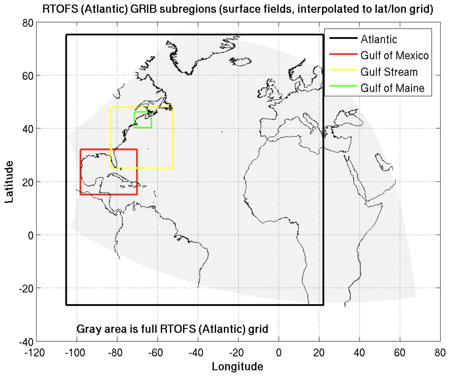
Figure 10RTOFS high-resolution oceanic model spatial domain including subregions (source: https://ocean.weather.gov/index.php, last access: 8 May 2025).
The NOAA Ocean Prediction Center (OPC), as part of NCEP, maintains and develops five operational desks that run in 10 h shift for the Atlantic Regional, the Atlantic High Seas, the Pacific Regional, the Pacific High Seas, and the Outlook. They are devoted to producing gridded forecasts for hazards, winds, waves, weather and ice accretion, focusing only on US exclusive economic zones. Products for the Atlantic and the Pacific Regional desks include 24 h surface and wind and wave forecasts, while the Atlantic and Pacific High Seas desks produce analysis two times per shift and 48 h forecasts. The Pacific High Seas includes Alaska and Arctic projections in addition to forecast products. The Outlook desk provides medium-range forecasts for 72 and 96 h (source: https://www.weather.gov/marine/, last access: 14 May 2025). In such a context, specific operational services are operated to provide valuable support for any meteo-marine emergency occurring in the region.
The operational Hurricane Analysis and Forecast System (HAFS; https://www.aoml.noaa.gov/hurricane-analysis-and-forecast-system/, last access: 8 May 2025) of NCEP has provided a reliable and skillful model on tropical cyclone track and intensity since 2023. It is forced by atmospheric fields provided by the NOAA Global Forecast System (NCEP GFS) and uses the RTOFS fields as ocean initial and boundary conditions. HAFS is configured with two storm-centric domains with nominal horizontal resolutions of 6 and 2 km, respectively.
The NOAA Tide Predictions (https://tidesandcurrents.noaa.gov/tide_predictions.html, last access: 8 May 2025) system provides tidal forecasts in specific stations located on the west coast, on the east coast, on the gulf coast, in the Pacific, and on the Caribbean islands. Queries are allowed on hourly, 15 min, and 6 min frequencies.
The Instituto de Ciencias de la Atmósfera y Cambio Climático at the Universidad Nacional Autónoma de México (UNAM) has developed and currently maintains a regional forecast system that includes meteorology (for Mexico and adjacent regions), ocean circulation (currently the Gulf of Mexico), waves (global and regional with higher resolution), sea level, tides and storm surge, volcanic ash dispersion, oil spill dispersion in the ocean, and fire smoke dispersion.
Table 2Principal characteristics of the core services operating in Mexico.
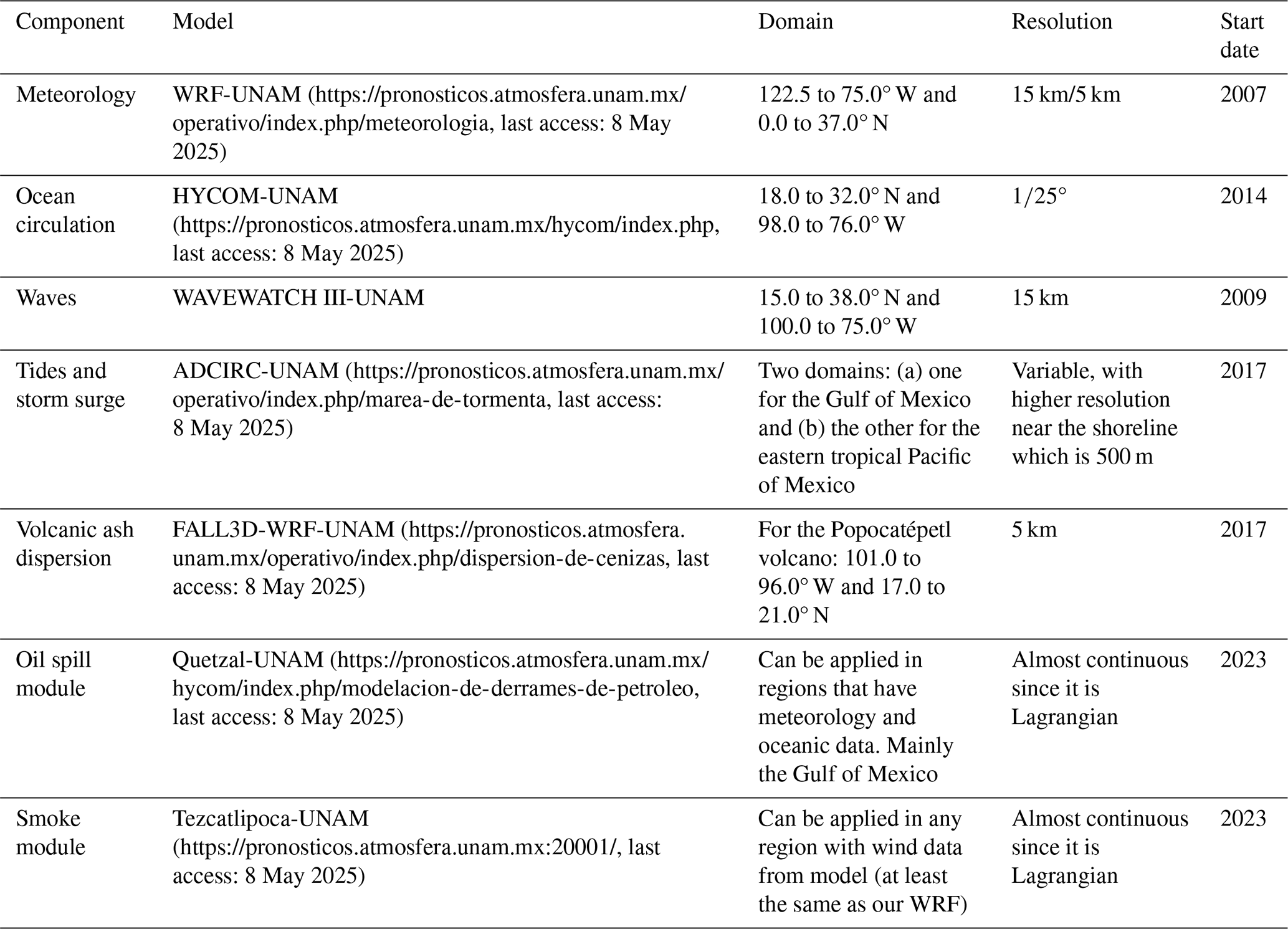
The different components of the system began to work in different years, and UNAM has tried to keep them working every day of the year, being successful at more than 99 % of the time. This system of models is the base of other systems that are developed for other institutions such as the Mexican National Weather Service, PEMEX (e.g., the national oil company), and CENAPRED, which is part of the national civil system protection. Table 2 summarizes the main characteristics of systems operating in Mexico.
The operational ocean circulation model for the Gulf of Mexico circulation operates at a resolution of ° of a degree using HYCOM, generating hourly output on a daily basis. The model utilizes a distinct bathymetry and coastline compared to the HYCOM Consortium's model. Surface forcings are provided by our WRF model, while global HYCOM data are used for open boundary conditions. Initial conditions are derived from global HYCOM, with a restart from the previous forecast if necessary. We are currently developing an in-house data assimilation technique for improving initial conditions. UNAM employs the WAVEWATCH III model on a structured grid for wave forecasting. A global wave model, driven by the Global Forecast System at a 1° resolution, provides boundary conditions for two regional models: one covering the Gulf of Mexico and the northwestern Caribbean Sea and the other covering the eastern tropical Pacific. Both regional models operate at a 15 km resolution, utilizing hourly surface forcings from our WRF model. Storm surge forecasting is conducted using the ADCIRC model on a non-structured mesh in two domains: one covering the Gulf of Mexico and the northwestern Caribbean Sea and the other covering the eastern tropical Pacific. The model resolution along the coastline of these domains is at least 500 m resolution. Open boundary conditions are provided by eight tide components from the TP9 model, with surface forcings obtained from our WRF model. The model produces forecasts for up to 120 h, with hourly outputs.
9.2 Coastal systems
In the fourth phase of growth in Canadian operational oceanography there was a recognition of the need for improved coastal surface currents to support environmental emergency response (e.g., for oil spills) and for electronic marine navigation (e-Nav) as part of the Government of Canada's Ocean Protection Plan (OPP). Supported by OPP funding, the CONCEPTS initiative developed a 2 km Coastal Ice-Ocean Prediction System (CIOPS) for the east and west coasts (Paquin et al., 2024). The ocean analyses for CIOPS are now used to initialize coupled atmosphere–ice–ocean forecasts covering the Great Lakes and Canadian east coast as part of the Water Cycle Prediction System (Durnford et al., 2018). As a result, the coupled GSL system was retired in 2021.
A cascade of grids was then used to provide boundary conditions from CIOPS for six port ocean prediction systems (POPSs). The POPS domains include Kitimat, Vancouver Harbor, and Fraser River on the west coast and Canso, St. John Harbor, and the St. Lawrence Estuary on the east coast (DFO, 2023). These systems provide high-resolution surface currents for electronic navigation, with resolutions down to 20 m (Paquin et al., 2020).
While various biogeochemical modeling applications have been made for Canadian coastal regions, these have yet to culminate in an organized operational service. Discussions are underway regarding the specific needs and how these can be met (Lavoie et al., 2025).
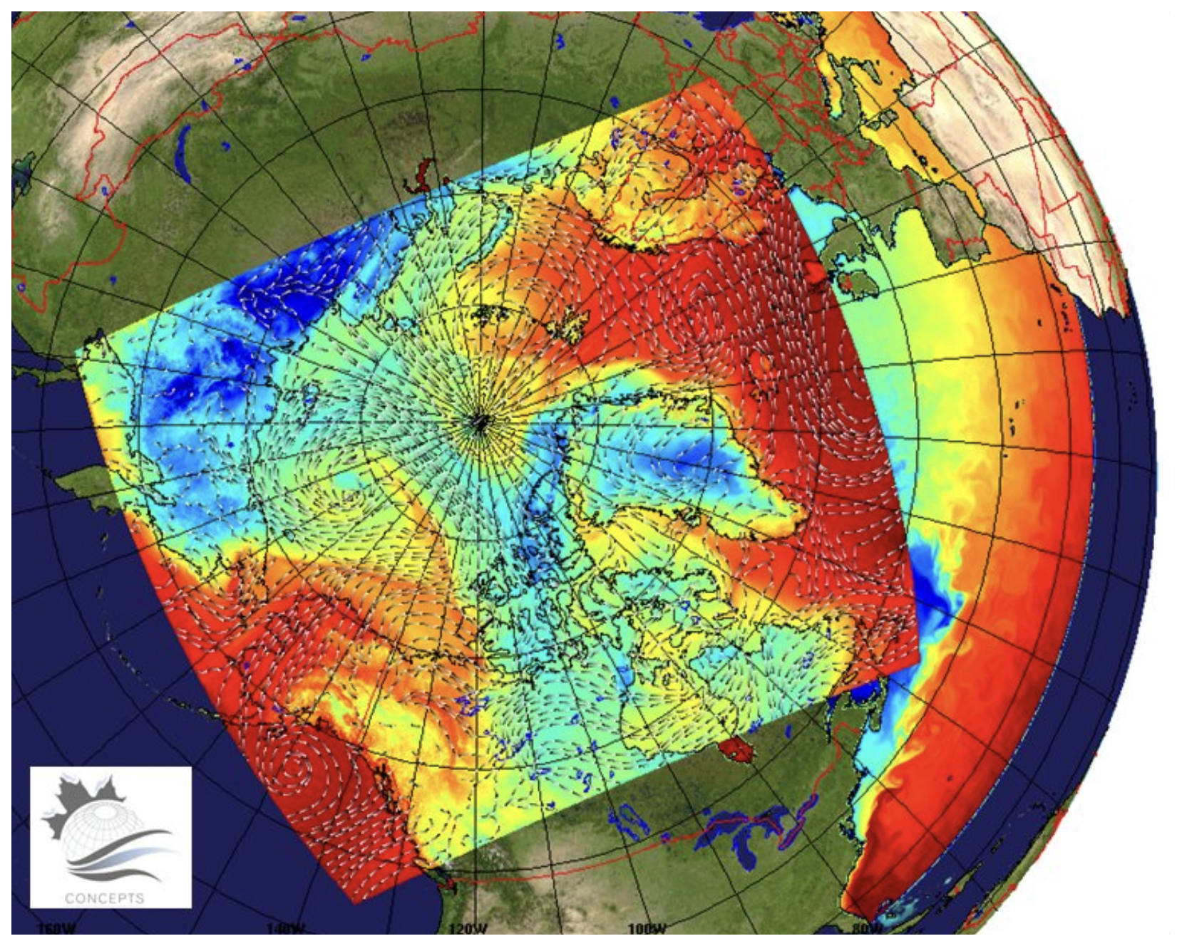
Figure 11Model domain used for the CONCEPTS Canadian Arctic Prediction System (CAPS), which includes a 3 km resolution atmospheric configuration coupled to the RIOPS ice–ocean configuration. The atmospheric surface temperature and winds are overlaid on a map of sea surface temperature for RIOPS. Note that the ice–ocean domain has been extended to include the North Pacific Ocean down to 44° N.
The operational CONCEPTS system products are available through the Meteorological Service of Canada Open Data platform (Data list/Liste des données – MSC Open Data/Données ouvertes du SMC), including direct data access and geospatial web services (Fig. 11). Data are also available for download and visualization from the Ocean Navigator (https://www.oceannavigator.ca/public/, last access: 8 May 2025).
At the coastal scale, many OOFSs are operated by NOAA/NCEP to support safety and navigation.
-
In the North Pacific, five systems are available:
-
The West Coast Operational Forecast System (WCOFS; https://tidesandcurrents.noaa.gov/ofs/wcofs/wcofs.html; last access: 14 May 2025) is a high-resolution forecasting system that operates on the west coast, providing 3 to 7 d forecasts for sea level, currents, temperature, and salinity. The system is based on ROMS, implemented in a spatial domain that stretches along the western coast of the North American continent from 24° N (Mexico) to 54° N (British Columbia), with a horizontal resolution that varies from 2 to 4 km. It assimilates SST, sea surface currents (SSUV), and SLAs using the 4DVAR scheme (Kurapov et al., 2017).
-
The Cook Inlet Operational Forecast System (CIOFS; https://tidesandcurrents.noaa.gov/ofs/ciofs/ciofs.html, last access: 8 May 2025) generates water levels, water temperature and salinity, and winds' nowcast and forecast up to 48 h, four times per day. The system is based on ROMS and uses an orthogonal grid with horizontal resolution that spans 10 m within the estuaries and navigation channels to 3.5 km near offshore waters.
-
The Salish Sea and Columbia River Operational Forecast System (SSCOFS; https://tidesandcurrents.noaa.gov/ofs/dev/sscofs/sscofs_info.html, last access: 8 May 2025) provides nowcast and forecast for water levels, currents, water temperature, and salinity, incorporating river forcing from available observations and tidal forcing. The model has an unstructured triangular grid. The resolution varies from ∼ 100 m along the shoreline to 500 m in deeper parts of Puget Sound and the Georgia Basin and increases to 10 000 m over the continental shelf. Resolution in the Columbia River varies between 100 and 200 m.
-
The San Francisco Bay Operational Forecast System (SFBOFS; https://tidesandcurrents.noaa.gov/ofs/sfbofs/sfbofs_info.html, last access: 8 May 2025) is based on FVCOM for providing nowcasts and forecasts of water levels, temperature, and salinity in the San Francisco Bay and in the San Francisco Bay Entrance. The grid has a minimum depth of 0.2 m and maximum depth of 106.8 m. Grid resolution ranges from 3.9 km on the open-ocean boundary to approximately 100 m near the coast, indicating the flexibility of the grid size based on bathymetry from the deep ocean to the coast. Additionally, the higher resolution along the navigational channels within the bay, from approximately 100 to 10 m, provides detailed current features.
-
-
In the Great Lakes, four FVCOM-based operational systems are available:
-
the Lake Erie Operational Forecast System (LEOFS; https://tidesandcurrents.noaa.gov/ofs/leofs/leofs_info.html; last access: 8 May 2025) at horizontal resolution from 400 m to 4 km, with higher resolution along the shoreline and in the shallow western basin and coarser resolution for the open waters in the middle and eastern basins;
-
the Lake Michigan and Huron Operational Forecast System (LMHOFS; https://tidesandcurrents.noaa.gov/ofs/lmhofs/lmhofs_info.html, last access: 8 May 2025), at horizontal resolution from 50 m to 2.5 km, with higher resolution along the shoreline and in the shallow western basin and coarser resolution for the open waters in both lakes;
-
the Lake Ontario Operational Forecast System (LHOFS; https://tidesandcurrents.noaa.gov/ofs/loofs/loofs_info.html, last access: 8 May 2025), at horizontal resolution from 200 m to 2.5 km, with higher resolution along the shoreline;
-
the Lake Superior Operational Forecast System (LSOFS; https://tidesandcurrents.noaa.gov/ofs/lsofs/lsofs_info.html, last access: 8 May 2025), at horizontal resolution 200 m to 2.5 km, with higher resolution along the shoreline.
-
-
In the Gulf of Mexico, two systems are available:
-
The northern Gulf of Mexico Operational Forecast System (NGOFS2; https://tidesandcurrents.noaa.gov/ofs/ngofs2/ngofs.html, last access: 8 May 2025) is based on FVCOM with a resolution from 10 km on the open ocean to approximately 600 m near the coast. Additional refinement of the grid is provided within the bays from 45 to 300 m. The system runs four times per day, providing a forecast up to 48 h.
-
The Tampa Bay Operational Forecast System (TBOFS; https://tidesandcurrents.noaa.gov/ofs/tbofs/tbofs_info.html, last access: 8 May 2025), based on ROMS, has a resolution from 100 m to 1.2 km. It has been designed to include the whole of Tampa Bay and the shelf to properly represent the dynamics at the entrance to the bay.
-
-
In the Atlantic, five ROMS-based systems provide nowcasts and forecasts up to 48 h four times per day:
-
the Chesapeake Bay Operational Forecast System (CBOFS; https://tidesandcurrents.noaa.gov/ofs/cbofs/cbofs_info.html, last access: 8 May 2025), with a resolution spanning 30 m to 4 km;
-
the Delaware Bay Operational Forecast System (DBOFS; https://tidesandcurrents.noaa.gov/ofs/dbofs/dbofs_info.html, last access: 8 May 2025), with a resolution ranging from 100 m up to 3 km;
-
the Gulf of Maine Operational Forecast System (GoMOFS; https://tidesandcurrents.noaa.gov/ofs/gomofs/gomofs_info.html, last access: 8 May 2025), at 700 m resolution approximately, with forecast horizon up to 72 h;
-
the New York and New Jersey Operational Forecast System (NYOFS; https://tidesandcurrents.noaa.gov/ofs/nyofs/nyofs.html, last access: 8 May 2025), which provides water levels and currents using a grid with horizontal resolution from 5 m to 7.5 km;
-
the St. John's River Operational Forecast System (SJROFS; https://tidesandcurrents.noaa.gov/ofs/sjofs/sjofs_info.html; last access: 8 May 2025), with horizontal resolution from 80 m to 4 km.
-
Academia, governmental institutes, and the private sector cooperate for improving numerical modeling, engaging the enterprise to accelerate scientific research and excellence in US coastal predictions. Examples of coastal systems that are developed in the United States include the following:
-
The Coastal Storm Modeling System (CoSMoS), developed by the United States Geological Survey (USGS), is a storm-induced coastal flooding, erosion, and cliff failures system for the north-central coast, San Francisco Bay, southern California, and the central California coast (Barnard et al., 2014).
-
The West Florida Coastal Ocean Model (WFCOM), developed by the USF College of Marine Science in Florida, is an unstructured grid FVCOM in the eastern Gulf of Mexico that provides water level (storm surge) forecasts as well as surface currents and surface salinity (Zheng and Weisberg, 2012).
-
The South Florida Hybrid Coordinate Ocean Model (SoFLA-HYCOM) Shelf Circulation, developed by the University of Miami, has a resolution that spans ° to 2 m close to the coast and includes shelf areas, shallow embayment, and the deep Straits of Florida (between Florida and Cuba) (Kourafalou et al., 2009).
-
LiveOcean, developed by the University of Washington – Coastal Modelling Group, is mainly used for research applications. It provides 3 d forecasts of currents, temperature, salinity, and many biogeochemical variables in the US Pacific Northwest. The model horizontal resolution is 500 m in the Salish Sea and near the Washington coast, growing to 3 km at the offshore boundaries (source: https://faculty.washington.edu/pmacc/LO/LiveOcean.html, last access: 14 May 2025).
In contrast to lower-latitude models, Arctic Ocean forecast models are focused on simulating the correct sea ice conditions, with the ocean below the mixed layer being of secondary importance on short timescales. However, this situation is expected to change with the retreating ice cover in the Arctic Ocean driving impacts on ocean ecosystems and increased activity across the Arctic region. There are 10 global models that are used for Arctic forecasting. There are also several regional models available and a handful of coastal models. Most models with Arctic forecasts are from national institutes that either represent large centers with dominant global forecasting platforms, have a large amount of Arctic research, or have an interest in maintaining a model due to having a border with the Arctic.
Given the focus around sea ice, there are several similarities across all forecasting systems, regardless of the domain. Firstly, all models must have a sea ice component. Almost all models use CICE as their sea ice model, with multiple sea ice thickness categories. The Arctic Ice Ocean Prediction System (ArcIOPS) uses the sea ice model in MITgcm, while VENUS uses the ice component of POM, the GLO-MFC physical analysis and forecasting system uses LIM2 and the Met Office FOAM and coupled models use CICE currently but will move to using SI3 in the future. The FIO-COM10 model uses the SIS sea ice model. The majority of forecasting models with an ocean component use HYCOM or NEMO for their ocean model; the exceptions are ArcIOPS (MITgcm), NOAA PSL (POP2), and FIO-COM10 (MOM5). Most of the models have an ice–ocean coupling and use an atmospheric forcing that has been created for a weather forecast; examples are those from ECMWF, the Regional Deterministic Prediction System, and NAVGEM. Four of the models identified – one regional model (NOAA PSL CAFS) and three global models (NAVY-ESPC, Met Office coupled system and ECMWF) – are fully coupled to the atmosphere.
Another similarity between all models is the output variables. Those models with an ocean component provide standard variables (temperature and salinity) with most also providing velocities and sea surface height. Each model also provides the standard sea ice variables (sea ice concentration, sea ice thickness, and sea ice velocities) as outputs, generally at hourly resolution. Additionally, all models use some form of data assimilation over the initial part of the simulation before the forecast begins (usually one day). This is an important part of Arctic forecasting given that the ability to forecast sea ice depends heavily on the initial conditions. Most models assimilate the standard ocean variables (SST, sea surface salinity (SSS), sea surface height (SSH), and temperature and salinity profiles) and sea ice concentration.
Finally, perhaps one of the most important considerations for users is whether the data are readily available and easily downloadable. The requirement for this varies greatly depending on the user, but those needing information on ships in the Arctic, for example, will need quick access across potentially low bandwidth. All models related to the Copernicus Marine Service (neXtSIM-F, TOPAZ5, Arctic Ocean Biogeochemistry Analysis and Forecast, and Global Ocean Physical Analysis and Forecasting) are available to download for free from the Copernicus Marine website, and there is a visualization tool on the information page. Most other modeling systems have data for download and a visualization, although sometimes in different places; these are the Barents-2.5km, NOAA ice drift, NOAA PSL, RIOPS, GIOPS, GOFS3.1, and RTOFS. The systems from DMI and GOFS16 have a web page displaying the forecasts. As noted in Sect. 9, the CONCEPTS systems (GIOPS, RIOPS, CIOPS) are available through the Meteorological Service of Canada Open Data platform (Sect. 9 provides additional details). The ArcIOPS, FIO-COM10 and NAVY-ESPC systems are well-documented in the literature, but it is hard to find a website that states where/if downloading is available. The latter suggests some outputs are available for researchers if they register for a login, but it is not stated how other users can access the data. Similarly, it is difficult to find information on how to access outputs from the Met Office FOAM and its coupled data assimilation counterpart. For the global ECMWF model, some data are available, but users must pay for other variables.
There are strong crossovers between the global and regional models, and therefore specific details of both domains (covering the full Arctic) are provided below together, followed by the Arctic coastal forecasts.
10.1 Regional systems
Several institutions are operating regional services in the Arctic
-
The Arctic Ice-Ocean Prediction System ArcIOPS, available at http://www.oceanguide.org.cn/IceIndexHome/ThicknessIce (last access: 8 May 2025; Liang et al., 2019), is managed by the National Marine Environmental Forecasting Center, China. It spans the Arctic region down to 55° north. It uses MITgcm and provides 168 h forecasts at 18 km resolution.
-
The Danish Meteorological Institute (DMI) operates an ocean forecasting system utilizing the HYCOM-CICE model (Ponsoni et al., 2023; https://ocean.dmi.dk/models/hycom.uk.php, last access: 8 May 2025). This coupled ocean and sea ice model covers the Atlantic Ocean north of approximately 15° S and the Arctic Ocean, including Greenlandic waters. The system features a horizontal resolution ranging from about 4–5 km in the Arctic regions to approximately 10 km further south. It is forced by atmospheric data from the European Centre for Medium-Range Weather Forecasts (ECMWF) and produces 144 h forecasts twice daily, at 00:00 and 12:00 UTC.
-
The neXtSIM-F forecasting system (Williams et al., 2021; https://data.marine.copernicus.eu/product/ARCTIC_ANALYSISFORECAST_PHY_ICE_002_011/description, last access: 8 May 2025) is a stand-alone sea ice model developed by the Nansen Environmental and Remote Sensing Centre (NERSC). It utilizes the neXtSIM model, forced by the TOPAZ ocean forecast and ECMWF atmospheric forecasts. The system assimilates OSI SAF (https://osi-saf.eumetsat.int/, last access: 8 May 2025) sea ice concentration products daily, adjusting initial conditions and applying compensating heat fluxes to enhance forecast accuracy.
-
The National Institute of Polar Research (NIPR; https://www.nipr.ac.jp/sea_ice/e/forecast/, last access: 8 May 2025) in Japan provides Arctic Sea ice forecasts through its Arctic Sea Ice Information Centre. These forecasts are disseminated periodically, with reports typically released in May, July, August, and October each year. The May to August reports focuses on predicting the opening dates of Arctic sea routes and the sea ice distribution through September, while the October report forecasts sea ice distribution for the period of sea ice extension from October onward.
-
The NOAA Physical Sciences Laboratory (PSL; https://psl.noaa.gov/forecasts/seaice/about.html, last access: 8 May 2025) operates the Coupled Arctic Forecast System (CAFS), an experimental sea ice forecasting model. CAFS is a fully coupled ice–ocean–atmosphere model adapted from the Regional Arctic System Model (RASM) and includes components such as the Weather Research and Forecasting (WRF) atmospheric model, the Parallel Ocean Program (POP) ocean model, the Los Alamos Community Ice Model (CICE), and the Community Land Model (CLM). All components run at a horizontal resolution of 10 km. The system is initialized with the NOAA Global Forecast System (NCEP GFS) analysis and Advanced Microwave Scanning Radiometer 2 (AMSR2) sea ice concentrations. CAFS produces 10 d sea ice forecasts daily, with outputs posted online at 02:00 UTC.
-
The Regional Ice-Ocean Prediction System (RIOPS; https://science.gc.ca/eic/site/063.nsf/eng/h_97620.html, last access: 8 May 2025; Smith et al., 2021) is operated by the Canadian Meteorological Centre (CMC). It employs the Nucleus for European Modelling of the Ocean (NEMO) coupled with the Los Alamos Sea Ice Model (CICE). The system is forced by atmospheric data from the Global Deterministic Prediction System (GDPS) and provides a forecast horizon of up to 48 h. The model domain covers the North Pacific Ocean from the Bering Strait and the whole of the Arctic Ocean and the North Atlantic down to 26° N, with a horizontal resolution of approximately 3–4 km over the Arctic Ocean. A fully coupled forecast system called the Canadian Arctic Prediction System, which uses RIOPS and a pan-Arctic atmospheric configuration at 2.5 km resolution, is currently being reinstated (see Sect. 8 for details) following its retirement in 2021.
-
The TOPAZ5 system (https://data.marine.copernicus.eu/product/ARCTIC_ANALYSISFORECAST_PHY_002_001/description, last access: 8 May 2025) is maintained by the NERSC. It utilizes the HYCOM model coupled with the Ensemble Kalman Filter for data assimilation. The system is forced by atmospheric data from the ECMWF and provides a forecast horizon of up to 10 d. The model domain encompasses the North Atlantic Ocean and the Arctic Ocean with a horizontal resolution of approximately 6.25 km.
-
The VENUS forecasting system (Yamaguchi, 2013) is operated by the Norwegian Meteorological Institute (MET Norway). It employs the NEMO ocean model coupled with the LIM3 sea ice model. The system is forced by atmospheric data from the AROME-Arctic weather prediction model and provides a forecast horizon of up to 66 h. The model domain covers the Barents Sea and adjacent Arctic waters with a horizontal resolution of 4 km.
There are several characteristics to be highlighted in these systems:
-
Most models are either coupled ice–ocean or coupled ice–ocean–atmosphere models. However, there are a few exceptions to this. The regional model neXtSIM-F is a standalone sea ice model that uses TOPAZ5 ocean and ECMWF atmosphere forecast forcings and therefore only outputs sea ice variables. It is the only model to use a Lagrangian framework and a non-standard rheology. TOPAZ5 is the only model that has a version with a coupling to ECOSMO, a biogeochemical model, and additionally assimilates chlorophyll for input to this.
-
The lowest resolution of the provided models is the regional ArcIOPS, at around 18 km. The resolution of the regional models is comparable to the global models.
-
Apart from RIOPS, which runs for 84 h at hourly resolution, most models covering the full Arctic domain provide outputs for 5 to 10 d, ranging from hourly output to daily output. NOAA ice drift and NAVY-ESPC provide forecasts for up to 16 d; the latter can also give information for up to 45 d but at a lower resolution.
-
Some models also provide additional sea ice variables; RIOPS, for example, and its global equivalent GIOPS, provide ice pressure, while TOPAZ5 provides sea ice type, albedo, and snow depth. The VENUS models include wave information. TOPAZ5 running with ECOSMO outputs several biogeochemical variables including dissolved inorganic carbon, oxygen, nitrate, chlorophyll, and phytoplankton.
-
The VENUS model is unique in that it provides map-based forecasts for aiding ship navigation (generally in support of research cruises) and is deployed on demand rather than running continuously.
10.2 Coastal systems
There are a few coastal models available in the Arctic region.
-
The coastal version of the DMI forecast model covers the Greenland region at 4–5 km resolution and uses HYCOM-CICE like its regional version. It produces forecasts up to 144 h ahead and is updated twice a day.
-
The Barents-2.5km model (https://ocean.met.no/models, last access: 8 May 2025) covers the Barents Sea and Svalbard region (Röhrs et al., 2023). ROMS is run at a spatial resolution of 2.5 km with an Arctic-specific atmospheric forcing, AROME-Arctic, providing forecasts up to 66 h ahead, and is updated every 6 h.
-
The “storm surge” service (https://ocean.met.no/models, last access: 8 May 2025) is a ROMS model run in barotropic mode, covering the northern North Atlantic, Barents Sea, and Svalbard up to the entrance to the Arctic Basin. It uses the MEPS 2.5 km atmospheric model for outputs, providing forecasts for 120 h updated every 6 h. Its main purpose is to simulate sea level and storm conditions.
-
The CIOPS-E system (Paquin et al., 2024) is a ° (around 2 km) resolution NEMO-CICE coupled model that is forced by the High-Resolution Deterministic Prediction System atmospheric forcing and covers the east coast of Canada. During its assimilation, it also uses RADARSAT satellite images. In addition to standard sea ice and ocean variables, it outputs snow depth on sea ice and ice pressure at hourly frequency for the following 48 h.
The global landscape of ocean forecasting services demonstrates a solid and mature foundation, particularly through the widespread availability and reliability of global models. These models provide essential large-scale information and underpin the functionality of numerous regional and coastal systems. However, despite their robustness, global models often lack the resolution required to address the finer-scale dynamics necessary for many localized applications, particularly in coastal zones and regions with complex bathymetry or strong human–ocean interactions.
A clear disparity exists in the coverage and capabilities of regional and coastal forecasting systems. Some areas, particularly in developed regions, benefit from dense, high-resolution services, while others – especially in less-resourced coastal regions – remain underrepresented or underserved. Furthermore, while physical and wave modeling systems have seen significant advancements and widespread implementation, biogeochemical models lag behind in both availability and operational maturity. This gap limits our ability to provide comprehensive ecosystem forecasts and hampers decision-making related to marine biodiversity, fisheries, and water quality.
Looking forward, emerging technologies such as artificial intelligence (AI; Heimbach et al., 2025, in this report) hold immense potential to bridge these gaps. AI techniques can enhance model downscaling, fill data-sparse regions, and optimize system performance, thereby reducing disparities in forecasting capacities globally. However, while technological solutions are making impressive advancements and can have a great impact in the implementation of the ocean value chain (Ciliberti and Coro, 2025, in this report; Porter and Heimbach, 2025, in this report) they remain insufficient on their own. Continued efforts in community building, knowledge sharing, and capacity development are paramount. Initiatives such as those promoted under the United Nations Decade of Ocean Science for Sustainable Development provide critical platforms for fostering collaboration, developing shared tools, and ensuring equitable access to forecasting capabilities across all regions.
In this context, the OceanPrediction DCC Architecture (Alvarez Fanjul et al., 2024a) offers a significant opportunity to promote the development of robust ocean forecasting services worldwide. By providing a structured, modular framework for the development of forecasting systems, it facilitates interoperability, scalability, and the integration of these systems. The concept of the Operational Readiness Level for ocean forecasting (Alvarez Fanjul et al., 2024b), developed within the DCC framework, will contribute to the quality of the system by supporting the application of best practices. These tools, when combined, have the potential to accelerate the creation of new regional and coastal systems, while simultaneously enhancing the quality, reliability, and user engagement of existing ones.
By aligning technological innovation with inclusive community-driven approaches, the global ocean forecasting community can work towards a more comprehensive, high-resolution, and biogeochemically informed future, better serving society's growing and diverse needs.
No data sets were used in this article.
MC designed, supervised, and validated the overall manuscript. All authors contributed to writing and revising the paper. Section 2 was additionally revised by EAF. EAF and MC conceptualized and wrote Sect. 1. WM wrote Sect. 3, SJ wrote Sect. 4, JV and JS wrote Sect. 5, EC wrote Sect. 6, and AC and GES co-wrote Sect. 7. BD, MD, IM, DN, CGS, CAST, and MC collaborated on Sect. 8, while GCS, PH, SC, and JZH contributed to Sect. 9. HR wrote Sect. 10. EAF and MC also contributed to the Conclusions.
At least one of the (co-)authors is a member of the editorial board of State of the Planet. The peer-review process was guided by an independent editor, and the authors also have no other competing interests to declare.
Publisher's note: Copernicus Publications remains neutral with regard to jurisdictional claims made in the text, published maps, institutional affiliations, or any other geographical representation in this paper. While Copernicus Publications makes every effort to include appropriate place names, the final responsibility lies with the authors.
The authors appreciated the effort of the reviewers, whose constructive comments and suggestions greatly improved the quality of this paper.
This paper was edited by Swadhin Behera and reviewed by Pierre-Yves Le Traon and one anonymous referee.
Alonso, G., Simionato, C. G., Dinápoli, M. G., Saurral, R., and Bodnariuk, N.: Positive Storm Surges in the Río de la Plata Estuary: forcings, long-term variability, trends and linkage with Southwestern Atlantic Continental Shelf dynamics, Nat. Hazards, 120, 5007–5032, https://doi.org/10.1007/s11069-024-06402-w, 2024.
Álvarez Fanjul, E., Sotillo, M. G., Perez Gomez, B., Valdecasas, M. G., Perez Rubio, S., Lorente, P., Dapena, A. R., Martinez Marco, I., Luna, Y., Padorno, E., Santos Atienza, I., Hernandez, G. D., Lopez Lara, J., Medina, R., Grifoll, M., Espino, M., Mestres, M., Cerralbo, P., and Sanchez Arcilla, A.: Operational oceanography at the service of the ports, in: New Frontiers in Operational Oceanography, edited by: Chassignet, E., Pascual, A., Tintoré, J., and Verron, J., GODAE OceanView, 729–736, https://doi.org/10.17125/gov2018.ch27, 2018.
Alvarez Fanjul, E., Ciliberti, S., Pearlman, J., Wilmer-Becker, K., Ardhuin, F., Arnaud, A., Azizzadenesheli, K., Bahurel, P., Bell, M., Berthou, S. Bertino, L., Calewaert, J. B., Capet, A., Chassignet, E., Ciavatta, S., Cirano, M., Clementi, E., Cornacchia, L., Cossarini, G., Coro, G., Corney, S., Davidson, F., Drevillon, M., Drillet, Y., Dussurget, R., El Serafy, G., Fennel, K., Heimbach, P., Hernandez, F., Hogan, P., Hoteit, I., Joseph, S., Josey, S., Le Traon, P.-Y., Libralato, S., Mancini, M., Martin, M., Matte, P., Melet, A., Miyazawa, Y., Moore, A.M., Novellino, A., O'Donncha, F., Porter, A., Qiao, F., Regan, H., Schiller, A., Siddorn, J., Sotillo, M. G., Staneva, J., Thomas-Courcoux, C., Thupaki, P., Tonani, M., Garcia Valdecasas, J. M., Veitch, J., von Schuckmann, K., Wan, L., Wilkin, J., and Zufic, R.: The OceanPrediction DCC Architecture for Ocean Forecasting, OceanPrediction Decade Collaborative Centre, https://doi.org/10.48670/oofsarchitecture, 2024a.
Alvarez Fanjul, E., Ciliberti, S., Pearlman, J., Wilmer-Becker, K., Bahurel, P., Ardhuin, F., Arnaud, A., Azizzadenesheli, K., Aznar, R., Bell, M., Bertino, L., Behera, S., Brassington, G., Calewaert, J.B., Capet, A., Chassignet, E., Ciavatta, S., Cirano, M., Clementi, E., Cornacchia, L., Cossarini, G., Coro, G., Corney, S., Davidson, F., Drevillon, M., Drillet, Y., Dussurget, R., El Serafy, G., Fearon, G., Fennel, K., Ford, D., Le Galloudec, O., Huang, X., Lellouche, J.M., Heimbach, P., Hernandez, F., Hogan, P., Hoteit, I., Joseph, S., Josey, S., Le Traon, P.-Y., Libralato, S., Mancini, M., Martin, M., Matte, P., McConnell, T., Melet, A., Miyazawa, Y., Moore, A. M., Novellino, A., O'Donncha, F., Porter, A., Qiao, F., Regan, H., Robert-Jones, J., Sanikommu, S., Schiller, A., Siddorn, J., Sotillo, M. G., Staneva, J., Thomas-Courcoux, C., Thupaki, P., Tonani, M., Garcia Valdecasas, J.M., Veitch, J., von Schuckmann, K., Wan, L., Wilkin, J., Zhong, A., and Zufic, R.: Promoting best practices in ocean forecasting through an Operational Readiness Level, Front. Mar. Sci., 11, 1443284, https://doi.org/10.3389/fmars.2024.1443284, 2024b.
Arellano, C., Echevin, V., Merma-Mora, L., Chamorro, A., Gutierrez, D., Aguirre-Velarde, A., Tam, J., and Colas, F.: Circulation and stratification drivers during the summer season in the upwelling bay of Paracas (Peru): A modelling study, Cont. Shelf Res., 254, 104923, https://doi.org/10.1016/j.csr.2022.104923, 2023.
Astudillo, O., Dewitte, B., Mallet, M., Rutllant, J. A., Goubanova, K., Frappart, F., Ramos, M., and Bravo, L. : Sensitivity of the near-shore oceanic circulation off Central Chile to coastal wind profiles characteristics, J. Geophys. Res.-Oceans, 124, 4644–4676, https://doi.org/10.1029/2018JC014051, 2019.
Augusto Souza Tanajura, C., Novaes Santana, A., Mignac, D., Nascimento Lima, L., Belyaev, K., and Ji-Ping, X.: The REMO Ocean Data Assimilation System into HYCOM (RODAS_H): General Description and Preliminary Results, Atmospheric and Oceanic Science Letters, 7, 464–470, https://doi.org/10.3878/j.issn.1674-2834.14.0011, 2014.
Aumont, O., Ethé, C., Tagliabue, A., Bopp, L., and Gehlen, M.: PISCES-v2: an ocean biogeochemical model for carbon and ecosystem studies, Geosci. Model Dev., 8, 2465–2513, https://doi.org/10.5194/gmd-8-2465-2015, 2015.
Baretta, J. W., Ebenhöh, W., and Ruardij, P.: The European regional seas ecosystem model, a complex marine ecosystem model, Netherlands J. Sea Res., 33, 233–246, https://doi.org/10.1016/0077-7579(95)90047-0, 1995.
Barnard, P. L., van Ormondt, M., Erikson, L. H., Eshleman, J., Hapke, C., Ruggiero, P., Adams, P. N., and Foxgrover, A. C.: Development of the Coastal Storm Modeling System (CoSMoS) for predicting the impact of storms on high-energy, active-margin coasts, Nat. Hazards, 74, 1095–1125, https://doi.org/10.1007/s11069-014-1236-y, 2014.
Barnes, M. A. and Rautenbach, C.: Toward operational wave-current interactions over the Agulhas Current system, J. Geophys. Res.-Oceans, 125, e2020JC016321, https://doi.org/10.1029/2020JC016321, 2020.
Blumberg, A. F. and Mellor, G. L.: A description of a three-dimensional coastal ocean circulation model. Three-Dimensional Coastal ocean Models, edited by: Heaps, N., Coastal and Estuarine Sciences, American Geophysical Union, 208 pp., 1987.
Booij, N., Ris, R. C., and Holthuijsen, L. H.: A third-generation wave model for coastal regions: 1. Model description and validation, J. Geophys. Res.-Oceans, 104, 7649–7666, https://doi.org/10.1029/98JC02622, 1999.
Brassington, G. B., Sakov, P., Divakaran, P., Aijaz, S., Sweeney-Van Kinderen, J., Huang, X., and Allen, S.: OceanMAPS v4. 0i: a global eddy resolving EnKF ocean forecasting system, in: OCEANS 2023-Limerick, Limerick, Ireland, 5–8 June 2023, IEEE, 1–8, https://doi.org/10.1109/OCEANSLimerick52467.2023.10244383, 2023.
Bruschi, A., Lisi, I., De Angelis, R., Querin, S., Cossarini, G., Di Biagio, V., Salon, S., Solidoro, C., Fassina, D., Ancona, S., and Silvestri, C.: Indexes for the assessment of bacterial pollution in bathing waters from point sources: The northern Adriatic Sea CADEAU service, J. Environ. Manage., 293, 112878, https://doi.org/10.1016/j.jenvman.2021.112878, 2021.
Buehner, M., Caya, A., Carrieres, T., and Pogson, L.: Assimilation of SSMIS and ASCAT data and the replacement of highly uncertain estimates in the Environment Canada Regional Ice Prediction System, Q. J. Roy. Meteor. Soc., 142, 562–573, https://doi.org/10.1002/qj.2408, 2016.
Capet, A., Meysman, F., Akoumianaki, I., Soeteart, K., and Gregoire, M.: Integrating sediment biogeochemistry into 3D oceanic models: A study of benthic-pelagic coupling in the Black Sea, Ocean Model., 101, 83–100, https://doi.org/10.1016/j.ocemod.2016.03.006, 2016.
Capet, A., Fernández, V., She, J., Dabrowski, T., Umgiesser, G., Staneva, J., Mészáros, L., Campuzano, F., Ursella, L., Nolan, G., and El Serafy, G.: Operational Modeling Capacity in European Seas – An EuroGOOS Perspective and Recommendations for Improvement, Front. Mar. Sci., 7, 129, https://doi.org/10.3389/fmars.2020.00129, 2020.
Casati, B., Robinson, T., Lemay, F., Køltzow, M., Haiden, T., Mekis, E., Lespinas, F., Fortin, V., Gascon, G., Milbrandt, J., and Smith, G.: Performance of the Canadian Arctic prediction system during the YOPP special observing periods, Atmos.-Ocean, 61, 246–272, https://doi.org/10.1080/07055900.2023.2191831, 2023.
Ciliberti, S. and Coro, G.: Distributed Environments for Ocean Forecasting: the role of Cloud Computing, in: Ocean prediction: present status and state of the art (OPSR), edited by: Álvarez Fanjul, E., Ciliberti, S. A., Pearlman, J., Wilmer-Becker, K., and Behera, S., Copernicus Publications, State Planet, 5-opsr, 24, https://doi.org/10.5194/sp-5-opsr-24-2025, 2025.
Ciliberti, S. A., Grégoire, M., Staneva, J., Palazov, A., Coppini, G., Lecci, R., Peneva, E., Matreata, M., Marinova, V., Masina, S., Pinardi, N., Jansen, E., Lima, L., Aydoğdu, A., Creti’, S., Stefanizzi, L., Azevedo, D., Causio, S., Vandenbulcke, L., Capet, A., Maulders, C., Ivanov, E., Behrens, A., Ricker, M., Gayer, G., Palermo, F., Ilicak, M., Gunduz, M., Valcheva, N., and Agostini, P.: Monitoring and Forecasting the Ocean State and Biogeochemical Processes in the Black Sea: Recent Developments in the Copernicus Marine Service, J. Mar. Sci. Eng., 9, 1146, https://doi.org/10.3390/jmse9101146, 2022.
Coppini, G., Clementi, E., Cossarini, G., Salon, S., Korres, G., Ravdas, M., Lecci, R., Pistoia, J., Goglio, A. C., Drudi, M., Grandi, A., Aydogdu, A., Escudier, R., Cipollone, A., Lyubartsev, V., Mariani, A., Cretì, S., Palermo, F., Scuro, M., Masina, S., Pinardi, N., Navarra, A., Delrosso, D., Teruzzi, A., Di Biagio, V., Bolzon, G., Feudale, L., Coidessa, G., Amadio, C., Brosich, A., Miró, A., Alvarez, E., Lazzari, P., Solidoro, C., Oikonomou, C., and Zacharioudaki, A.: The Mediterranean Forecasting System – Part 1: Evolution and performance, Ocean Sci., 19, 1483–1516, https://doi.org/10.5194/os-19-1483-2023, 2023.
Craig, A., Valcke, S., and Coquart, L.: Development and performance of a new version of the OASIS coupler, OASIS3-MCT_3.0, Geosci. Model Dev., 10, 3297–3308, https://doi.org/10.5194/gmd-10-3297-2017, 2017.
Davidson, F., Robertson, A., Vitart, F., Rea, A., Jean, M., Schiller, A., Cuff, T. J., Grimes, S., Lim, E., de Coning, E., and Shi, P.: Ocean Prediction – modelling for the future, WMO Magazine, https://wmo.int/media/magazine-article/ocean-prediction-modelling-future (last access: 28 February 2025), 2021.
Debreu, L., Marchesiello, P., Penven, P., and Cambon, G.: Two-way nesting in split-explicit ocean models: Algorithms, implementation and validation, Ocean Model., 49–50, 1–21, https://doi.org/10.1016/j.ocemod.2012.03.003, 2012.
de Vos, M., Barnes, M., Biddle, L. C., Swart, S., Ramjukadh, C. L., and Vichi, M.: Evaluating numerical and free-drift forecasts of sea ice drift during a Southern Ocean research expedition: An operational perspective, J. Oper. Oceanogr., 15, 187–203, https://doi.org/10.1080/1755876X.2021.1883293, 2021.
DFO: Application of high-resolution hydrodynamic prediction systems for forecasting of ocean conditions in Canadian ports and approaches, National Peer Review – National Capital Region, 14–16 and 21–23 March 2023, Virtual Meeting, https://www.dfo-mpo.gc.ca/csas-sccs/Schedule-Horraire/2023/03_14-23-eng.html (last access: 26 May 2025), 2023.
Di Maio, A., Martin, M. V., and Sorgente, R.: Evaluation of the search and rescue LEEWAY model in the Tyrrhenian Sea: a new point of view, Nat. Hazards Earth Syst. Sci., 16, 1979–1997, https://doi.org/10.5194/nhess-16-1979-2016, 2016.
Dinápoli, M. G. and Simionato, C. G.: An integrated methodology for post-processing ensemble prediction systems to produce more representative extreme water level forecasts: the case of the Río de la Plata estuary, Nat. Hazards, 114, 2927–2940, https://doi.org/10.1007/s11069-022-05499-1, 2022.
Dinápoli, M. G. and Simionato, C. G.: Study of the tidal dynamics in the Southwestern Atlantic Continental Shelf based on data assimilation, Ocean Model., 188, 102332, https://doi.org/10.1016/j.ocemod.2024.102332, 2024.
Dinapoli, M. G. and Simionato, C. G.: On the impact of Southeastern Pacific‐generated storm surges on the Southwestern Atlantic Continental Shelf: Interoceanic connections through coastally trapped waves, J. Geophys. Res.-Oceans, 130, e2024JC021685, https://doi.org/10.1029/2024JC021685, 2025.
Dinápoli, M. G., Simionato, C. G., and Moreira D.: Model Sensitivity during Extreme Positive and Negative Surges in the Río de la Plata Estuary: Highlighting the Need for an Appropriate Hindcast/Forecast System, Weather Forecast., 35, 1097–1112, https://doi.org/10.1175/WAF-D-19-0171.1, 2020a.
Dinápoli, M. G., Simionato, C. G., and Moreira D.: Nonlinear tide-surge interactions in the Río de la Plata Estuary, Estuar. Coast. Shelf Sci., 241, 106834, https://doi.org/10.1016/j.ecss.2020.106834, 2020b.
Dinápoli, M. G., Simionato, C. G., and Moreira D.: Development and evaluation of an ensemble forecast/hindcast system for storm surges in the Río de la Plata Estuary, Q. J. Roy. Meteor. Soc., 147, 557–572, https://doi.org/10.1002/qj.3933, 2021.
Dinápoli, M. G., Ruiz, J. J., Simionato, C. G., and Berden, G.: Improving the short-range forecast of storm surges in the southwestern Atlantic continental shelf using 4DEnSRF data assimilation, Q. J. Roy. Meteor. Soc., 149, 2333–2347, https://doi.org/10.1002/qj.4509, 2023.
Dinápoli, M. G., Simionato, C. G., Alonso, G., Bodnariuk, N., and Saurral, R.: Negative storm surges in the Río de la Plata Estuary: mechanisms, variability, trends and linkage with the Continental Shelf dynamics,Estuarine, Coast. Shelf Sci., 305, 108844, https://doi.org/10.1016/j.ecss.2024.108844, 2024.
Dobricic, S. and Pinardi N.: An oceanographic three-dimensional variational data assimilation scheme, Ocean Model., 22, 89–105, 2008.
Dupont, F., Higginson, S., Bourdallé-Badie, R., Lu, Y., Roy, F., Smith, G. C., Lemieux, J.-F., Garric, G., and Davidson, F.: A high-resolution ocean and sea-ice modelling system for the Arctic and North Atlantic oceans, Geosci. Model Dev., 8, 1577–1594, https://doi.org/10.5194/gmd-8-1577-2015, 2015.
Durnford, D., Fortin, V., Smith, G.C., Archambault, B., Deacu, D., Dupont, F., Dyck, S., Martinez, Y., Klyszejko, E., MacKay, M., and Liu, L.: Toward an operational water cycle prediction system for the Great Lakes and St. Lawrence River, B. Am. Meteorol. Soc., 99, 521–546, https://doi.org/10.1175/BAMS-D-16-0155.1, 2018.
Federico, I., Pinardi, N., Coppini, G., Oddo, P., Lecci, R., and Mossa, M.: Coastal ocean forecasting with an unstructured grid model in the southern Adriatic and northern Ionian seas, Nat. Hazards Earth Syst. Sci., 17, 45–59, https://doi.org/10.5194/nhess-17-45-2017, 2017.
Feng, B., Wang, Z., Zhang, Y., and Wan, L.: Numerical Simulation of the Northwest Pacific Based on the MaCOM, J. Phys. Conf. Ser., 2718, 012029, https://doi.org/10.1088/1742-6596/2718/1/012029, 2024.
Ferrarin, C., Roland, A., Bajo, M., Umgiesser, G., Cucco, A., Davolio, S., Buzzi, A., Malguzzi, P., and Drofa, O.: Tide-surge-wave modelling and forecasting in the Mediterranean Sea with focus on the Italian coast, Ocean Model. 61, 38–48, https://doi.org/10.1016/j.ocemod.2012.10.003, 2013.
Ferrarin, C., Davolio, S., Bellafiore, D., Ghezzo, M., Maicu, F., McKiver, W., Drofa, O., Umgiesser, G., Bajo, M., De Pascalis, F., Malguzzi, P., Zaggia, L., Lorenzetti, G., and Manfé, G.: Cross-scale operational oceanography in the Adriatic Sea, J. Oper. Oceanogr., 12, 86–103, https://doi.org/10.1080/1755876X.2019.1576275, 2019.
Franz, G., Garcia, C. A. E., Pereira, J., de Freitas Assad, L. P., Rollnic, M., Garbossa, L. H. P., da Cunha, L. C., Lentini, C. A. D., Nobre, P., Turra, A., Trotte-Duhá, J. R., Cirano, M., Estefen, S. F., Lima, J. A. M., Paiva, A. M., Noernberg, M. A., Tanajura, C. A. S., Moutinho, J. L., Campuzano, F., Pereira, E. S., Lima, A. C., Mendonça, L. F. F., Nocko, H., Machado, L., Alvarenga, J. B. R., Martins, R. P., Böck, C. S., Toste, R., Landau, L., Miranda, T., dos Santos, F., Pellegrini, J., Juliano, M., Neves, R., and Polejack, A.: Coastal Ocean Observing and Modeling Systems in Brazil: Initiatives and Future Perspectives, Front. Mar. Sci., 8, 681619, https://doi.org/10.3389/fmars.2021.681619, 2021.
García-León, M., Sotillo, M. G., Mestres, M., Espino, M., Fanjul, and E. A.: Improving Operational Ocean Models for the Spanish Port Authorities: Assessment of the SAMOA Coastal Forecasting Service Upgrades, J. Mar. Sci. Eng., 10, 149, https://doi.org/10.3390/jmse10020149, 2022.
Goddard, L., González Romero, C., Muñoz, Á. G., Acharya, N., Ahmed, S., Baethgen, W., Blumenthal, B., Braun, M., Campos, D., Chourio, X., Cousin, R., Cortés, C., Curtis, A., del Corral, J., Dinh, D., Dinku, T., Fiondella, F., Furlow, J., García-López, A., Giraldo Mendez, D., Gómez, R., Grossi, A., Hailemariam, K., Hansen, J., Hassan, Q., Hoang, L., Jordan, P., List, G., Mannan, M. A., Mason, S. J., Melo, J., Navarro-Racines, C., Ndiaye, O., Nguyen-Quang, T., Nguyen-Van, T., Oliva, J. P., Osgood, D., Pons, D., Prager, S. D., Hernandez Quevedo, M., Robertson, A. W., Ramírez Villegas, J., Ruiz, J. F., Rojas, O., Schubmann, L., Teshome, F., Thomson, M., Turner, J. Trzaska, S., Van Mai, K., Vadillo, A., Vicencio, J. M., and Vu-Van, T.: Climate Services Ecosystems in times of COVID-19, WMO at 70 – Responding to a Global Pandemic, WMO Bulletin, 69, 39–46, https://wmo.int/media/magazine-article/climate-services-ecosystems-times-of-covid-19 (last access: 14 May 2025), 2020.
Goessling, H. F., Jung, T., Klebe, S., Baeseman, J., Bauer, P., Chen, P., Chevallier, M., Dole, R., Gordon, N., Ruti, P., and Bradley, A.: Paving the way for the year of polar prediction, B. Am. Meteorol. Soc., 97, ES85–ES88, https://doi.org/10.1175/BAMS-D-15-00270.1, 2016.
Grégoire, M., Raick, C., and Soetaert, K.: Numerical modeling of the deep Black Sea ecosystem functioning during the late 80's (eutrophication phase), Prog. Oceanogr., 76, 286–333, https://doi.org/10.1016/j.pocean.2008.01.002, 2008.
Gurvan, M., Bourdalle'-Badie, R., Chanut, J., Clementi, E., Coward, A., Ethe', C., Iovino, D., Lea, D., Levy, C., Lovato, T., Martin, N., Masson, S., Movavero, S., Rousset, C., Storkey, D., Mueller, S., Nurser, G., Bell, M., Samson, G., Mathiot, P., Mele, F., Moulin, A.: NEMO ocean engine, Zenodo, https://doi.org/10.5281/zenodo.6334656, 2022.
Heimbach, P., O'Donncha, F., Smith, T., Garcia-Valdecasas, J. M., Arnaud, A., and Wan, L.: Crafting the Future: Machine Learning for Ocean Forecasting, in: Ocean prediction: present status and state of the art (OPSR), edited by: Álvarez Fanjul, E., Ciliberti, S. A., Pearlman, J., Wilmer-Becker, K., and Behera, S., Copernicus Publications, State Planet, 5-opsr, 22, https://doi.org/10.5194/sp-5-opsr-22-2025, 2025.
Hoteit, I., Abualnaja, Y., Afzal, S., Ait-El-Fquih, B., Akylas, T., Antony, C., Dawson, C., Asfahani, K., Brewin, R. J., Cavaleri, L., Cerovecki, I., Cornuelle, B., Desamsetti, S., Attada, R., Dasari, H., Sanchez-Garrido, J., Genevier, L., El Gharamti, M., Gittings, J. A., Gokul, E., Gopalakrishnan, G., Guo, D., Hadri, B., Hadwiger, M., Abed Hammoud, M., Hendershott, M., Hittawe, M., Karumuri, A., Knio, O., Köhl, S., Kortas, S., Krokos, G., Kunchala, R., Issa, L., Lakkis, I., Langodan, S., Lermusiaux, P., Luong, T., Ma, J., Le Maitre, O., Mazloff, M., El Mohtar, S., Papadopoulos, V. P., Platt, T., Pratt, L., Raboudi, N., Racault, M.-F., Raitsos, D. E., Razak, S., Sanikommu, S., Sathyendranath, S., Sofianos, S., Subramanian, A., Sun, R., Titi, E., Toye, H., Triantafyllou, G., Tsiaras, K., Vasou, P., Viswanadhapalli, Y., Wang, Y., Yao, F., Zhan, P., and Zodiatis, G.: Towards an End-to-End Analysis and Prediction System for Weather, Climate, and Marine Applications in the Red Sea, B. Am. Meteorol. Soc., 102, E99–E122, https://doi.org/10.1175/BAMS-D-19-0005.1, 2021.
Jayson-Quashigah, P. N., Staneva, J., Chen, W., and Djath, B.: Exploring the Role of Mangroves as Nature-Based Solutions in Coastal Erosion Management: A What-If Analysis, Nature Based Solutions, in review, 2025.
Jin, H., Kim, Y. H., Park, Y.-G., Chang, I., Chang, Y.-S., Park, H., and Pak, G.: Simulation Characteristics of Ocean Predictability Experiment for Marine environment (OPEM): A Western North Pacific Regional Ocean Prediction System, Ocean Sci. J., 59, 71, https://doi.org/10.1007/s12601-024-00195-6, 2024.
Juza, M., Mourre, B., Renault, L., Gómara, S., Sebastián, K., Lora, S., Beltran, J. P., Frontera, B., Garau, B., Troupin, C., Torner, M., Heslop, E., Casas, B., Escudier, R., Vizoso, G., and Tintoré, J.: SOCIB operational ocean forecasting system and multi-platform validation in the Western Mediterranean Sea, J. Oper. Oceanogr., 9, s155–s166, https://doi.org/10.1080/1755876X.2015.1117764, 2016.
Kalaroni, S., Tsiaras, K., Petihakis, Economou-Amilli, A., and Triantafyllou, G.: Modelling the Mediterranean Pelagic Ecosystem using the POSEIDON ecological model. Part I: Nutrients and Chlorophyll-a dynamics, Deep-Sea Res. Pt. II, 171, 104647, https://doi.org/10.1016/j.dsr2.2019.104647, 2020a.
Kalaroni, S., Tsiaras, K., Petihakis, G., Economou-Amilli, A., and Triantafyllou, G.: Modelling the Mediterranean Pelagic Ecosystem using the POSEIDON ecological model. Part II: Biological dynamics, Deep-Sea Res. Pt. II, 171, 104711, https://doi.org/10.1016/j.dsr2.2019.104711, 2020b.
Kido, S., Nonaka, M., and Miyazawa, Y.: JCOPE-FGO: an eddy-resolving quasi-global ocean reanalysis product, Ocean Dynam. 72, 599–619, https://doi.org/10.1007/s10236-022-01521-z, 2022.
Korres, G. and Lascaratos, A.: A one-way nested eddy resolving model of the Aegean and Levantine basins: implementation and climatological runs, Ann. Geophys., 21, 205–220, https://doi.org/10.5194/angeo-21-205-2003, 2003.
Korres, G., Hoteit, I., and Triantafyllou, G.: Data assimilation into a Princeton Ocean Model of the Mediterranean Sea using advanced Kalman filters, J. Mar. Syst., 65, 84–104, https://doi.org/10.1016/j.jmarsys.2006.09.005, 2007.
Kourafalou, V. H., Peng, G., Kang, H., Hogan, P. J., Smedstad, O.-M., and Weisberg, R. H.: Evaluation of Global Ocean Data Assimilation Experiment products on South Florida nested simulations with the Hybrid Coordinate Ocean Model, Ocean Dynam. 59, 47–66, https://doi.org/10.1007/s10236-008-0160-7, 2009.
Kurapov, A. L., Erofeeva, S. Y., and Myers, E.: Coastal sea level variability in the US West Coast Ocean forecast system (WCOFS), Ocean Dynam., 67, 23–36, https://doi.org/10.1007/s10236-016-1013-4, 2017.
Lavoie, D., Bourgault-Brunelle, C., Brickman, D., Gibb, O., Guyondet, T., Niemi, A., Peña, A., Shen, H., and Soontiens, N.: Biogeochemical modelling at DFO: overview and recommendations of the biogeochemical modelling working group, Canadian Technical Report of Hydrography and Ocean Sciences 388, 1488–5417, https://publications.gc.ca/collections/collection_2025/mpo-dfo/Fs97-18-388-eng.pdf (last access: 14 May 2025), 2025.
Lemieux, J. F., Beaudoin, C., Dupont, F., Roy, F., Smith, G. C., Shlyaeva, A., Buehner, M., Caya, A., Chen, J., Carrieres, T., and Pogson, L.: The Regional Ice Prediction System (RIPS): verification of forecast sea ice concentration, Q. J. Roy. Meteor. Soc., 142, 632–643, https://doi.org/10.1002/qj.2526, 2016.
Le Traon, P. Y., Reppucci, A., Alvarez Fanjul, E., Aouf, L., Behrens, A., Belmonte, M., Bentamy, A., Bertino, L., Brando, V. E., Kreiner, M. B., Benkiran, M., Carval, T., Ciliberti, S. A., Claustre, H., Clementi, E., Coppini, G., Cossarini, G., De Alfonso Alonso-Muñoyerro, M., Delamarche, A., Dibarboure, G., Dinessen, F., Drevillon, M., Drillet, Y., Faugere, Y., Fernández, V., Fleming, A., Garcia-Hermosa, M. I., Sotillo, M. G., Garric, G., Gasparin, F., Giordan, C., Gehlen, M., Gregoire, M. L., Guinehut, S., Hamon, M., Harris, C., Hernandez, F., Hinkler, J. B., Hoyer, J., Karvonen, J., Kay, S., King, R., Lavergne, T., Lemieux-Dudon, B., Lima, L., Mao, C., Martin, M. J., Masina, S., Melet, A., Buongiorno Nardelli, B., Nolan, G., Pascual, A., Pistoia, J., Palazov, A., Piolle, J. F., Pujol, M. I., Pequignet, A. C., Peneva, E., Pérez Gómez, B., Petit de la Villeon, L., Pinardi, N., Pisano, A., Pouliquen, S., Reid, R., Remy, E., Santoleri, R., Siddorn, J., She, J., Staneva, J., Stoffelen, A., Tonani, M., Vandenbulcke, L., von Schuckmann, K., Volpe, G., Wettre, C., and Zacharioudaki, A.: From Observation to Information and Users: The Copernicus Marine Service Perspective, Front. Mar. Sci., 6, 23, https://doi.org/10.3389/fmars.2019.00234, 2019.
Liang, X., Fu, Z., Li, C., Lin, Z., and Li, B.: Evaluation of ArcIOPS sea ice forecasting products during the ninth CHINARE-Arctic in Summer 2018, Advances in Polar Science, 31, 14–25, https://doi.org/10.13679/j.advps.2019.0019, 2019.
Lima, J. A. M., Parkinson Martins, R., Tanajura, C. A. S., de Moraes Paiva, A., Cirano, M., Dias Campos, E. J., Dias Soares, I., Borges França, G., de Souza Obino, R., and Bosco Rodrigues Alvarenga, J.: Design and implementation of the Oceanographic Modeling and Observation Network (REMO) for operational oceanography and ocean forecasting, Brazilian Journal of Geophysics, 31, 209–228, https://doi.org/10.22564/rbgf.v31i2.290, 2013.
Liu, T. and Hirose, N.: Comparison of surface and lateral boundary conditions controlled by pseudo-altimeter data assimilation for a regional Kuroshio model, J. Oceanogr., 78, 73–88, https://doi.org/10.1007/s10872-021-00629-y, 2022.
Lyard, F. H., Allain, D. J., Cancet, M., Carrère, L., and Picot, N.: FES2014 global ocean tide atlas: design and performance, Ocean Sci., 17, 615–649, https://doi.org/10.5194/os-17-615-2021, 2021.
Marshall, J., Adcroft, A., Hill, C., Perelman, L., and Heisey, C.: A finite-volume, incompressible Navier Stokes model for studies of the ocean on parallel computers. J. Geophys. Res.-Oceans, 102, 5753–5766, https://doi.org/10.1029/96JC02775, 1997.
Mehra, A. and Rivin, I.: A Real Time Ocean Forecast System for the North Atlantic Ocean, Terr. Atmos. Ocean. Sci., 21, 211–228, https://doi.org/10.3319/TAO.2009.04.16.01(IWNOP), 2010.
Miyazawa, Y., Zhang, R., Guo, X., Tamura, H., Ambe, D., Lee, J.-S., Okuno, A., Yoshinari, H., Setou, T., and Komatsu, K.: Water mass variability in the western North Pacific detected in a 15-year eddy resolving ocean reanalysis, J. Oceanogr., 65, 737–756, https://doi.org/10.1007/s10872-009-0063-3, 2009.
Miyazawa, Y., Varlamov, S. M., Miyama, T., Kurihara, Y., Murakami, H., and Kachi, M.: A nowcast/forecast system for Japan's coasts using daily assimilation of remote sensing and in situ data, Remote Sens., 13, 2431, https://doi.org/10.3390/rs13132431, 2021.
Montes, I., Dewitte, B., Gutknecht, E., Paulmier, A., Dadou, I., Oschlies, A., and Garçon, V.: High-resolution modeling of the Oxygen Minimum Zone of the Eastern Tropical Pacific: Sensitivity to the tropical oceanic circulation, J. Geophys. Res.-Oceans, 119, 5515–5532, https://doi.org/10.1002/2014JC009858, 2014.
Montes, I., Segura, B., Castillón, F., Manay, R., Mosquera, K., and Takahashi, K.: Pronósticos experimentales del posible FEN para la Comisión ENFEN con un modelo de Sistema Tierra de alta resolución para el territorio nacional y el Pacífico oriental, Informe Técnico, https://www.gob.pe/institucion/igp/informes-publicaciones/5119632-pronosticos-experimentales-del-posible-fen-para-la-comision-enfen-con-un-modelo-de-sistema-tierra-de-alta-resolucion-para-el-territorio-nacional-y-el-pacifico-oriental (last access: 26 July 2024), 2023.
Mosquera-Vasquez, K., Dewitte, B., and Illig, S.: The Central Pacific El Nino intraseasonal Kelvin wave, J. Geophys. Res.-Oceans, 119, 6605–6621, https://doi.org/10.1002/2014JC010044, 2014
Mourre, B., Aguiar, E., Juza, M., Hernandez-Lasheras, J., Reyes, E., Heslop, E., Escudier, R., Cutolo, E., Ruiz, S., Mason, E., Pascual, A., Tintoré, J.: Assessment of high-resolution regional ocean prediction systems using muli-platform ob-servations: illustrations in the Western Mediterranean Sea, in: New Frontiers in Operational Oceanography, edited by: Chassignet, E., Pascual, A., Tintoré, J., and Verron, J., GODAE OceanView, 663–694, https://doi.org/10.17125/gov2018.ch24, 2018.
Napolitano, E., Iacono, R., Palma, M., Sannino, G., Carillo, A., Lombardi, E., Pisacane, G., and Struglia, M. V.: MITO: A new operational model for the forecasting of the Mediterranean Sea circulation, Front. Energy Res., 10, 1296, https://doi.org/10.3389/fenrg.2022.941606, 2022.
Palma, M., Iacono, R., Sannino, G., Bargagli, A., Carillo, A., Fekete, B. M., Lombardi, E., Napolitano, E., Pisacane, G., and Struglia, M. V.: Short-term, linear, and non-linear local effects of the tides on the surface dynamics in a new, high-resolution model of the Mediterranean Sea circulation, Ocean Dynam., 70, 935–963, https://doi.org/10.1007/s10236-020-01364-6, 2020.
Paquin, J. P., Lu, Y., Taylor, S., Blanken, H., Marcotte, G., Hu, X., Zhai, L., Higginson, S., Nudds, S., Chanut, J., and Smith, G. C.: High-resolution modelling of a coastal harbour in the presence of strong tides and significant river runoff, Ocean Dynam., 70, 365–385, https://doi.org/10.1007/s10236-019-01334-7, 2020.
Paquin, J. P., Roy, F., Smith, G. C., MacDermid, S., Lei, J., Dupont, F., Lu, Y., Taylor, S., St-Onge-Drouin, S., Blanken, H., and Dunphy, M.: A new high-resolution Coastal Ice-Ocean Prediction System for the east coast of Canada, Ocean Dynam., 74, 799–826, https://doi.org/10.1007/s10236-024-01634-7, 2024.
Pellerin, P., Ritchie, H., Saucier, F. J., Roy, F., Desjardins, S., Valin, M., and Lee, V.: Impact of a two-way coupling between an atmospheric and an ocean-ice model over the Gulf of St. Lawrence, Mon. Weather Rev., 132, 1379–1398, https://doi.org/10.1175/MWR-D-17-0157.1, 2004.
Peterson, K. A., Smith, G. C., Lemieux, J. F., Roy, F., Buehner, M., Caya, A., Houtekamer, P. L., Lin, H., Muncaster, R., Deng, X., and Dupont, F.: Understanding sources of Northern Hemisphere uncertainty and forecast error in a medium-range coupled ensemble sea-ice prediction system, Q. J. Roy. Meteor. Soc., 148, 2877–2902, https://doi.org/10.1002/qj.4340, 2022.
Pinardi, N., Allen, I., Demirov, E., De Mey, P., Korres, G., Lascaratos, A., Le Traon, P.-Y., Maillard, C., Manzella, G., and Tziavos, C.: The Mediterranean ocean forecasting system: first phase of implementation (1998–2001), Ann. Geophys., 21, 3–20, https://doi.org/10.5194/angeo-21-3-2003, 2003.
Pizarro-Koch, M., Pizarro, O., Dewitte, B., Montes, I., Ramos, M., Paulmier, A., and Garcon, V.: Seasonal variability of the southern tip of the Oxygen Minimum Zone in the Eastern South Pacific (30°–38° S): A modeling study, J. Geophys. Res.-Oceans, 124, 8574–8604, https://doi.org/10.1029/2019JC015201, 2019.
Ponsoni, L., Ribergaard, M. H., Nielsen-Englyst, P., Wulf, T., Buus-Hinkler, J., Kreiner, M. B., and Rasmussen, T. A. S.: Greenlandic sea ice products with a focus on an updated operational forecast system, Front. Mar. Sci., 10, 979792, https://doi.org/10.3389/fmars.2023.979782, 2023.
Porter, A. R. and Heimbach, P.: Unlocking the Power of Parallel Computing: GPU technologies for Ocean Forecasting, in: Ocean prediction: present status and state of the art (OPSR), edited by: Álvarez Fanjul, E., Ciliberti, S. A., Pearlman, J., Wilmer-Becker, K., and Behera, S., Copernicus Publications, State Planet, 5-opsr, 23, https://doi.org/10.5194/sp-5-opsr-23-2025, 2025.
Qiao, F., Wang, G., Khokiattiwong, S., Akhir, M. F., Zhu, W., and Xiao, B.: China published ocean forecasting system for the 21st-Century Maritime Silk Road on December 10, 2018, Acta Oceanol. Sin., 38, 1–3, https://doi.org/10.1007/s13131-019-1365-y, 2019.
Reche, P., Artal, O., Pinilla, E., Ruiz, C., Venegas, O., Arriagada, A., and Falvey, M.: CHONOS: oceanographic information website for Chilean Patagonia, Ocean Coast. Manage., 208, 105634, https://doi.org/10.1016/j.ocecoaman.2021.105634, 2021.
Röhrs, J., Gusdal, Y., Rikardsen, E. S. U., Durán Moro, M., Brændshøi, J., Kristensen, N. M., Fritzner, S., Wang, K., Sperrevik, A. K., Idžanović, M., Lavergne, T., Debernard, J. B., and Christensen, K. H.: Barents-2.5km v2.0: an operational data-assimilative coupled ocean and sea ice ensemble prediction model for the Barents Sea and Svalbard, Geosci. Model Dev., 16, 5401–5426, https://doi.org/10.5194/gmd-16-5401-2023, 2023.
Sakov, P., Evensen, G., and Bertino, L.: Asynchronous data assimilation with the EnKF, Tellus A, 62, 24–29, https://doi.org/10.1111/j.1600-0870.2009.00417.x, 2010.
Sannino, G., Carillo, A., Iacono, R., Napolitano, E., Palma, M., Pisacane, G., and Struglia, M. V.: Modelling present and future climate in the Mediterranean Sea: a focus on sea-level change, Clim. Dynam., 59, 357–391, https://doi.org/10.1007/s00382-021-06132-w, 2022.
Saucier, F. J., Roy, F., Gilbert, D., Pellerin, P., and Ritchie, H.:. Modeling the formation and circulation processes of water masses and sea ice in the Gulf of St. Lawrence, Canada, J. Geophys. Res.-Oceans, 108, 3269, https://doi.org/10.1029/2000JC000686, 2003.
Saucier, F. J., Senneville, S., Prinsenberg, S., Roy, F., Smith, G., Gachon, P., Caya, D., and Laprise, R.:. Modelling the sea ice-ocean seasonal cycle in Hudson Bay, Foxe Basin and Hudson Strait, Canada, Clim. Dynam., 23, 303–326, https://doi.org/10.1007/s00382-004-0445-6, 2004.
Segura, B., Montes, I., Castillón, F., Manay R., and Takahashi, K.: Implementación del componente acoplado océano-atmósfera del Modelo Regional del Sistema Tierra (RESM, por sus siglas en inglés) para el territorio peruano y el océano Pacífico oriental: periodo enero-julio 2023. Boletín científico El Niño, Instituto Geofísico del Perú, 10, 10–13, https://repositorio.igp.gob.pe/server/api/core/bitstreams/77707dc7-eb95-45a2-ab47-b2974ca77bfa/content (last access: 26 July 2024), 2023.
Simionato, C. G., Meccia, V. L., Dragani, W. C., and Nuñez, M. N.: On the use of the NCEP/NCAR surface winds for modelling barotropic circulation in the Río de la Plata Estuary, Estuar. Coast. Shelf Sci., 70, 195–206, https://doi.org/10.1016/j.ecss.2006.05.047, 2006.
Smith, G. C., Davidson, F., and Lu, Y.: The CONCEPTS Initiative: Canadian Operational Network of Coupled Environmental Prediction Systems, J. Ocean Technol., 8, 80–81, https://www.thejot.net/article-preview/?show_article_preview=510 (last access: 26 May 2025), 2013a.
Smith, G. C., Roy, F., and Brasnett, B.: Evaluation of an operational ice–ocean analysis and forecasting system for the Gulf of St Lawrence, Q. J. Roy. Meteor. Soc., 139, 419–433, https://doi.org/10.1002/qj.1982, 2013b.
Smith, G. C., Roy, F., Reszka, M., Surcel Colan, D., He, Z., Deacu, D., Belanger, J. M., Skachko, S., Liu, Y., Dupont, F., and Lemieux, J. F.: Sea ice forecast verification in the Canadian global ice ocean prediction system, Q. J. Roy. Meteor. Soc., 142, 659–671, https://doi.org/10.1002/qj.2555, 2016.
Smith, G. C., Bélanger, J. M., Roy, F., Pellerin, P., Ritchie, H., Onu, K., Roch, M., Zadra, A., Colan, D. S., Winter, B., and Fontecilla, J. S.: Impact of coupling with an ice–ocean model on global medium-range NWP forecast skill, Mon. Weather Rev., 146, 1157–1180, https://doi.org/10.1175/MWR-D-17-0157.1, 2018.
Smith, G. C., Liu, Y., Benkiran, M., Chikhar, K., Surcel Colan, D., Gauthier, A.-A., Testut, C.-E., Dupont, F., Lei, J., Roy, F., Lemieux, J.-F., and Davidson, F.: The Regional Ice Ocean Prediction System v2: a pan-Canadian ocean analysis system using an online tidal harmonic analysis, Geosci. Model Dev., 14, 1445–1467, https://doi.org/10.5194/gmd-14-1445-2021, 2021.
Sorgente, R., Tedesco, C., Pessini, F., De Dominicis, M., Gerin, R., Olita, A., Fazioli, L., Di Maio A., and Ribotti, A.: Forecast of drifter trajectories using a Rapid Environmental Assessment based on CTD observations, Deep-Sea Res. Pt. II, 133, 39–53, https://doi.org/10.1016/j.dsr2.2016.06.020, 2016.
Sotillo, M. G., Cerralbo, P., Lorente, P., Grifoll, M., Espino, M., Sanchez-Arcilla, A., and Alvarez-Fanjul, E.: Coastal ocean forecasting in Spanish ports: the Samoa operational service, J. Oper. Oceanogr., 13, 37–54, https://doi.org/10.1080/1755876X.2019.1606765, 2019.
Srinivasan, A., Chin, T. M., Chassignet, E. P., Iskandarani, M., and Groves, N.: A Statistical Interpolation Code for Ocean Analysis and Forecasting, J. Atmos. Ocean. Tech., 39, 367–386, https://doi.org/10.1175/JTECH-D-21-0033.1, 2022.
Tanajura, C. A. S., Mignac, D., de Santana, A. N., Costa, F. B., Lima, L. N., Belyaev, K. P., and Zhu, J.: Observing system experiments over the Atlantic Ocean with the REMO ocean data assimilation system (RODAS) into HYCOM, Ocean Dynam., 70, 115–138, https://doi.org/10.1007/s10236-019-01309-8, 2020.
The Wamdi Group: The WAM model – a third generation ocean wave prediction model, J. Phys. Oceanogr., 18, 1775–1810, https://doi.org/10.1175/1520-0485(1988)018<1775:TWMTGO>2.0.CO;2, 1988.
Tintoré, J., Pinardi, N., Álvarez-Fanjul, E., Aguiar, E., Álvarez-Berastegui, D., Bajo, M., Balbin, R., Rozzano, R., Buongiorno Nardelli, B., Casas, B., Charcos-Llorens, M., Chiggiato, J., Clementi, E., Coppini, G., Coppola, L., Cossarini, G., Deidun, A., Deudero, S., D’Ortenzio, F., Drago, A., Drudi, M., El Serafi, G., Escudier, R., Farcy, P., Federico, I., Fernandez, J. G., Ferrarin, C., Fossi, C. Frangoulis, C., Galgani, F., Gana, S., Lafuente, J. G., Sotillo, M. G., Garreau, P., Gertman, I., Gómez-Pujol, L., Grandi, A., Hayes, D., Hernández-Lasheras, J., Herut, B., Heslop, E., Hilmi, K., Juza, M., Kallos, G., Korres, G., Lecci, R., Lazzari, P., Lorente, P., Liubartseva, S., Luoanchi, F., Malacic, V., Mannarini, G., March, D., Marullo, S., Mauri, E., Meszaros, L., Mourre, B., Mortier, L., Muñoz-Mas, C., Novellino, A., Obaton, D., Orfila, A., Pascual, A., Pensieri, S., Pérez Gómez, B., Pérez Rubio, S., Perivoliotis, L., Petihakis, G., Petit de la Villéon, L. Pistoia, J., Poulain, P.-M., Pouliquen, S., Prieto, L., Raimbault, P., Reglero, P., Reyes, E., Rotllan, P., Ruiz, S., Ruiz, J., Ruiz, I., Ruiz-Orejón, L. F., Salihoglu, B., Salon, S., Sammartino, S., Sánchez Arcilla, A., Sánchez-Román, A., Sannino, G., Santoleri, R., Sarda’, R., Schroeder, K., Simoncelli, S., Sofianos, S., Sylaios, G., Tanhua, T., Teruzzo, A., Testor, P., Tezcam, D., Torner, M., Trotta, F., Umgiesser, G., von Schuckmann, K., Verri, G., Vilibic, I., Yucel, M., Zavatarelli, M., and Zodiatis, G.: Challenges for sustained observing and Forecasting systems in the Mediterranean Sea, Front. Mar. Sci., 6, 568, https://doi.org/10.3389/fmars.2019.00568, 2019.
Toledano, C., Ghantous, M., Lorente, P., Dalphinet, A., Aouf, L., and Sotillo, M. G.: Impacts of an Altimetric Wave Data Assimilation Scheme and Currents-Wave Coupling in an Operational Wave System: The New Copernicus Marine IBI Wave Forecast Service, J. Mar. Sci. Eng., 10, 457, https://doi.org/10.3390/jmse10040457, 2022.
Tolman, H. L.: User manual and system documentation of WAVEWATCH III version 3.14, U.S. Department of Commerce, National Oceanic and Atmospheric Administration, National Weather Service, National Centers for Environmental Prediction, https://polar.ncep.noaa.gov/mmab/papers/tn276/MMAB_276.pdf (last access: 16 March 2025), 2009.
Tolman, H. L., Balasubramaniyan, B., Burroughs, L. D., Chalikov, D. V., Chao, Y. Y., Chen H. S., and Gerald, V. M.: Development and implementation of wind generated ocean surface wave models at NCEP, Weather Forecast., 17, 311–333, https://doi.org/10.1175/1520-0434(2002)017<0311:DAIOWG>2.0.CO;2, 2002.
Umgiesser, G., Canu, D.M., Cucco A., and Solidoro, C.: A finite element model for the Venice Lagoon. Development, set up, calibration and validation, J. Marine Syst., 51, 123–145, https://doi.org/10.1016/j.jmarsys.2004.05.009, 2004.
Urbano-Latorre, C. P., Dagua Paz, C. J., and Camilo Martiìnez, A. F.: Análisis del clima marítimo de aguas intermedias y su potencial energético en la zona de influencia de los principales puertos del Caribe colombiano, Bol. Cien. CIOH, 42, 27–46, https://doi.org/10.26640/22159045.2023.620, 2023.
Vichi, M., Lovato, T., Butenschön, M., Tedesco, L., Lazzari, P., Cossarini, G., Masina, S., Pinardi, N., Solidoro, C., and Zavatarelli, M.: The Biogeochemical Flux Model (BFM): Equation Description and User Manual, BFM version 5.2. BFM Report series N. 1, Release 1.2, June 2020, Bologna, Italy, 104 pp., http://bfm-community.eu (last access: 14 May 2025), 2020.
Whitaker, J. S. and Hamill, T. M.: Ensemble data assimilation without perturbed observations, Mon. Weather Rev., 130, 1913–1924, https://doi.org/10.1175/1520-0493(2002)130<1913:EDAWPO>2.0.CO;2, 2002.
Williams, T., Korosov, A., Rampal, P., and Ólason, E.: Presentation and evaluation of the Arctic sea ice forecasting system neXtSIM-F, The Cryosphere, 15, 3207–3227, https://doi.org/10.5194/tc-15-3207-2021, 2021.
Wu, Y., Tang, C., and Dunlap, E.: Assimilation of sea surface temperature into CECOM by flux correction, Ocean Dynam., 60, 403–412, 2010.
Yamaguchi, H.: Sea ice prediction and construction of an ice navigation support system for the Arctic sea routes. Proceedings of the 22nd International Conference on Port and Ocean Engineering under Arctic Conditions, 9–13 June 2013, Espoo, Finland, http://worldcat.org/issn/03766756 (last access: 26 May 2025), 2013.
Yiwen, L., Liu, J., Lin, P., Liu, H., Yu, Z., and Zheng, W.: An assessment of marine heat waves in a global eddy-resolving ocean forecast system: A case study around the China Sea, J. Mar. Sci. Eng., 5, 965, https://doi.org/10.3390/jmse11050965, 2023.
Zheng, L. and Weisberg, R. H.: Modeling the west Florida coastal ocean by downscaling from the deep ocean, across the continental shelf and into the estuaries, Ocean Model., 48, 10–29, https://doi.org/10.1016/j.ocemod.2012.02.002, 2012.
Zodiatis, G., Lardner, R., Lascaratos, A., Georgiou, G., Korres, G., and Syrimis, M.: High resolution nested model for the Cyprus, NE Levantine Basin, eastern Mediterranean Sea: implementation and climatological runs, Ann. Geophys., 21, 221–236, https://doi.org/10.5194/angeo-21-221-2003, 2003.
Zodiatis, G., Lardner, R., Hayes, D. R., Georgiou, G., Sofianos, S., Skliris, N., and Lascaratos, A.: Operational ocean forecasting in the Eastern Mediterranean: implementation and evaluation, Ocean Sci., 4, 31–47, https://doi.org/10.5194/os-4-31-2008, 2008.
Zodiatis, G., Radhakrishnan, H., Galanis, G., Nikolaidis, A., Emmanouil, G., Nikolaidis, G., Lardner, R., Stylianou, S., Nikolaidis, M., Sofianos, S. S., Vervatis, V., Kallos, G. B., Kozyrakis, G., and Kampis, N.: Downscaling the Copernicus Marine Service in the Eastern Mediterranean. OM14A: Advances in Coastal Ocean Modeling, Prediction, and Ocean Observing System Evaluation. AGU, Ocean Science meeting, 11–16 February 2018, Portland, Oregon, https://agu.confex.com/agu/os18/meetingapp.cgi/Paper/304719 (last access: 26 May 2025), 2018.
- Abstract
- Introduction
- Global ocean forecasting services
- West Pacific and Marginal Seas of South and East Asia
- Indian Seas
- African Seas
- Mediterranean and Black Sea
- North East Atlantic
- South and Central America
- North America
- Arctic region
- Conclusions
- Data availability
- Author contributions
- Competing interests
- Disclaimer
- Acknowledgements
- Review statement
- References
Please read the editorial note first before accessing the article.
- Article
(11281 KB) - Full-text XML
- Abstract
- Introduction
- Global ocean forecasting services
- West Pacific and Marginal Seas of South and East Asia
- Indian Seas
- African Seas
- Mediterranean and Black Sea
- North East Atlantic
- South and Central America
- North America
- Arctic region
- Conclusions
- Data availability
- Author contributions
- Competing interests
- Disclaimer
- Acknowledgements
- Review statement
- References