the Creative Commons Attribution 4.0 License.
the Creative Commons Attribution 4.0 License.
 | 02 Jun 2025 | OPSR | Chapter 4.1
Connecting ocean observations with prediction
Pierre-Yves Le Traon
Antonio Novellino
Andrew M. Moore
Ocean prediction relies on the integration between models and satellite and in situ observations through data assimilation techniques. Nowadays, satellites offer high-resolution observations of essential ocean variables at the surface, widely adopted in combination with precise but sparse in situ measurements that, from the surface to the deep ocean, can constrain large-scale variability in models. Moreover, observations are a valuable source of information for validating and assessing model products, for improving them, and for developing the next generation of machine learning algorithms aimed at enhancing the accuracy and scope of ocean forecasts. The authors discuss the role of observations in operational ocean forecasting systems, describing the state of the art of satellite and in situ observing networks and defining the paths for addressing multi-scale monitoring and forecasting.
- Article
(910 KB) - Full-text XML
- BibTeX
- EndNote


Ocean prediction relies on the integration between models and satellite and in situ observations through data assimilation techniques (Bell et al., 2015). Data assimilation provides a 4D dynamical interpolation of observations by considering the complementarities between the different types of observations. High-spatial-resolution (e.g. from 10 km at global scale to 1 km or less at regional and coastal scales) and high-temporal-resolution (e.g. daily) ocean fields consistent with observations and model dynamics are thus derived and can be used to initialise ocean forecast models. The development of machine learning techniques such as deep neural networks offer different and complementary pathways for ocean prediction. Machine learning techniques analyse and learn from patterns in past data or ocean reanalyses to make ocean predictions from current data. Several studies have already shown the potential of machine-learning-based ocean forecast systems (e.g. Chen et al., 2023).
Whatever the techniques used to produce them, the quality of ocean analyses and forecasts observations at global and regional/coastal scales is directly dependent on the availability of high-quality in situ and satellite observations with a sufficient space and time resolution. These dependencies vary according to ocean dynamics. Data assimilation is, for example, mandatory and quite effective for constraining the mesoscale variability at global and regional scales. At coastal scales, it is more challenging to constrain ocean dynamics where small-scale, high-frequency and non-linear processes play an important role.
Observations are also essential to validate ocean analysis and prediction models (e.g. Gutknecht et al., 2019), to improve ocean models (required for assessment of model performances, for ocean prediction and for digital twins) (e.g. Wang et al., 2021), and for training machine learning algorithms.
For both data assimilation and validation aspects, data must be carefully validated, and information on data errors must be documented. Higher-quality reprocessed data sets are required for reanalyses.
The monitoring of the impact of observations should be part of any ocean prediction activity. This is done through Observing System Evaluations (OSEs) and Observing System Simulation Experiments (OSSEs) (Fujii et al., 2019; Gasparin et al., 2019). OSEs allow the impact of an existing observing system to be assessed (by withholding observations). OSSEs help in the design of new observing systems, evaluate their different configurations and perform preparatory data assimilation work. Other complementary approaches for quantifying the impact of observations on ocean analysis and forecast systems also exist (Fujii et al., 2019; Drake et al., 2023).
In the following sections we briefly review the role of the different ocean observing systems in ocean prediction at global, regional and coastal scales. Sections 2 and 3 deal, respectively, with satellite and in situ observations.
Satellite observations have a major role in and impact on ocean prediction (Le Traon, 2018). Satellites can provide real-time and global observations of key ocean variables at high space and time resolution: sea level and geostrophic currents, sea surface temperature, ocean colour, sea ice, surface wave, and surface winds (Fig. 1). The spatial resolution depends on the nature of the sensor and ranges from a few hundreds of metres (e.g. infrared and ocean colour sensors) to tens of kilometres (e.g. microwave sensors). The time resolution or revisit time ranges from 1 h or less for geostationary satellites up to a few days or longer for polar-orbiting satellites.
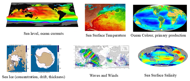
Figure 1The unique contribution of satellite oceanography for ocean prediction.
Ocean modelling and data assimilation systems have a high dependency on the status of the altimeter constellation (Le Traon et al., 2017). Satellite altimeters provide all-weather observations of sea level, which is an integral of the ocean interior and provides a strong constraint on ocean state estimation at the mesoscale. At least four altimeters are required, and a precise knowledge of the mean dynamic topography (MDT) is also a strong requirement for assimilation into operational ocean forecasting systems (Le Traon et al., 2017; Hamon et al., 2019).
Sea surface temperature (SST) is a key variable for all ocean prediction systems. SST data can be used to correct for errors in forcing fields (heat fluxes, wind) and to constrain the mesoscale variability of the upper ocean. High-resolution SST data from a combination of infrared (polar-orbiting and geostationary) (e.g. S3 SLSTR, VIIRS, GOES, MTG) and microwave sensors (e.g. AMSR-2) are thus essential to constrain ocean prediction systems.
Satellite sea ice concentration and, more recently, sea ice thickness data (SMOS and Cryosat) are routinely assimilated in sea ice models. The assimilation of sea ice drift remains challenging due to the short memory of sea ice drift and sea ice models deficiencies (Sakov et al., 2012). Numerous impact studies have been carried out for sea ice data assimilation, in particular for sea ice thickness products from Cryosat but also for thin ice thickness from SMOS and both satellites together (Xie et al., 2018).
Sea surface salinity (SSS) observations (SMOS, Aquarius, SMAP) from space (Reul et al., 2020) provide valuable information (Martin et al., 2019; Tranchant et al., 2019) for ocean prediction. Satellite SSS data assimilation can now constrain the model forecasts without introducing incoherent information compared to the other assimilated observations.
Satellite significant wave height observations are routinely assimilated in global and regional wave models, and their impact is very well demonstrated. Wave spectra provided by Sentinel-1 SAR instruments and, more recently, with the more precise CFOSAT SWIM instrument can, in addition, significantly improve the quality of wave forecasts (Aouf et al., 2021; Hauser et al., 2023).
Ocean colour missions (e.g. S3 OLCI, VIIRS) provide essential “green ocean” observations for a wide range of applications (e.g. water quality, eutrophication, harmful algal blooms). Higher-resolution and specialised ocean colour products (e.g. case-II water algorithms) are particularly needed for coastal areas. Ocean-colour data are being used to assess the performance of model simulations of chlorophyll-a (Chl-a) fields (Gutknecht et al., 2019) and to improve simulations through data assimilation (Ford et al., 2018; Fennel et al., 2019). However, the assimilation of ocean colour data is arguably less widespread than that of physical variables. The potential for ocean colour data to improve biogeochemical (BGC) models remains significant, though many challenges persist (e.g. error characterisation, observation operators such as bio-optical models and the integration of ocean colour data with in situ measurements like BGC Argo).
While wind observations from multiple scatterometers are essential for improving the forcing fields required for ocean prediction, the primary pathway for utilising scatterometer data is through assimilation in numerical weather prediction (NWP) systems. However, NWP data assimilation systems do not incorporate all the information available from scatterometers, particularly at smaller spatial scales (Belmonte Rivas and Stoffelen, 2019). Therefore, using these observations to directly constrain ocean models may be more beneficial.
In situ observing systems play a fundamental role to provide measurements of the ocean water column and to complement satellite observations. The combination of high-resolution satellite data with sparse and precise in situ observations of the ocean interior is the only means to provide a high-resolution 3D description and forecast of the ocean state. In situ temperature and salinity data are crucial to constrain large-scale variability in models (Gasparin et al., 2023). In situ observations of high-frequency and high-resolution ocean processes in the coastal zone are also essential to validate coastal ocean prediction systems.
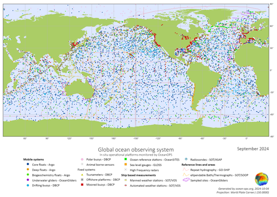
Figure 2In situ networks from the Global Ocean Observing System (GOOS).
Ocean prediction uses surface observations, vertical profiles and time series coming from different types of instruments (e.g. floats, drifters, moorings, marine mammals, gliders, tide gauges, research vessels, ships of opportunity, FerryBoxes, saildrones, high-frequency (HF) radars) and different parameters (temperature, salinity, currents, sea level, wave, chlorophyll, oxygen, nutrients, pH, fugacity of CO2) (Fig. 2).
Some available observations, such as from surface drifters, thermosalinographs (TSGs), and acoustic Doppler current profilers (ADCPs), are not always assimilated. However, non-assimilated observations are essential for the independent validation of analyses and forecasts, as well as for evaluating model and system improvements.
The global Argo array (Roemmich et al., 2019) plays a fundamental role in ocean prediction (Le Traon, 2013). Impact studies have confirmed and quantified the major impact of Argo on ocean analysis and forecasting systems (e.g. Turpin et al., 2016). The evolution of Argo into OneArgo, which includes deep and BGC components, already shows very promising results to improve ocean prediction systems (Gasparin et al., 2020; Cossarini et al., 2019; Wang et al., 2021; Mignot et al., 2023).
The most important other source of global observations is the surface drifter network, which provides data on surface currents; sea surface temperature; and, for some drifters, sea surface salinity. Additionally, met-ocean and deep-ocean mooring arrays (temperature, salinity, velocity, and biogeochemical parameters) (OceanSITES, including the TAO/PIRATA/TRITON tropical arrays) provide essential data to validate and constrain models. These are complemented by the Voluntary Observing Ship (VOS) network, which provides SST and SSS data as well as surface carbon measurements.
There is a growing need to increase in situ data coverage in shelf and coastal areas. Other data sources, such as HF radars, ferryboxes, gliders, tide gauges and coastal monitoring stations, are regularly used to validate and constrain ocean prediction models. Uncrewed surface vehicles (USVs), like saildrones, are also being used with increasing frequency. The assimilation of HF radar data in regional coastal models is an area of active development (Hernandez-Lasheras et al., 2021; Drake et al., 2023), and the assimilation of glider observations with sufficiently dense spatial and temporal sampling at regional and coastal scales has also proven highly effective (Pasmans et al., 2019; Levin et al., 2021; Drake et al., 2023). The development of low-cost technologies and citizen science can also support expanding coverage, particularly in coastal areas.
Ensuring the continuity of existing ocean observing systems is a necessary, but not sufficient, requirement for ocean prediction. Higher spatial and temporal resolution is required to match the increasing model resolution and improve the ability of ocean prediction systems to monitor and forecast smaller scales, including in coastal areas. In this regard, the development of operational swath altimetry (e.g. Morrow et al., 2019; Benkiran et al., 2022), following the outstanding results of the SWOT mission (Fu et al., 2024), is one of the most critical requirements for the evolution of the satellite observing system. For in situ observations, critical gaps remain in coastal areas, shelf seas and polar regions. On a global scale, the lack of biogeochemical observations limits our ability to monitor and forecast the “green ocean”, making the development of OneArgo a high priority. Data standardisation, quality assurance and quality control are also essential to ensure that ocean prediction systems make the best possible use of observations.
No data sets were used in this article.
PYLT wrote the paper. AN and AMM provided feedback on the paper content.
The contact author has declared that none of the authors has any competing interests.
Publisher’s note: Copernicus Publications remains neutral with regard to jurisdictional claims made in the text, published maps, institutional affiliations, or any other geographical representation in this paper. While Copernicus Publications makes every effort to include appropriate place names, the final responsibility lies with the authors.
This paper was edited by Jay Pearlman and reviewed by Peter Oke and one anonymous referee.
Aouf, L., Hauser, D., Chapron, B., Toffoli, A., Tourain, C., and Peureux, C.: New Directional Wave Satellite Observations: Towards Improved Wave Forecasts and Climate Description in the Southern Ocean, Geophys. Res. Lett., 48, e2020GL091187, https://doi.org/10.1029/2020GL091187, 2021.
Bell, M. J., Le Traon, P.-Y., Smith, N. R., Dombrowsky, E., and Wilmer-Becker, K.: An introduction to GODAE oceanview, J. Oper. Oceanogr., 8, 2–11, https://doi.org/10.1080/1755876X.2015.1022041, 2015.
Belmonte Rivas, M. and Stoffelen, A.: Characterizing ERA-Interim and ERA5 surface wind biases using ASCAT, Ocean Sci., 15, 831–852, https://doi.org/10.5194/os-15-831-2019, 2019.
Benkiran, M., Le Traon, P.-Y., and Dibarboure, G.: Contribution of a constellation of two wide-swath altimetry missions to global ocean analysis and forecasting, Ocean Sci., 18, 609–625, https://doi.org/10.5194/os-18-609-2022, 2022.
Chen, J., Ashton, I. G. C., Steele, E. C. C., and Pillai, A. C.: A Real-Time Spatiotemporal Machine Learning Framework for the Prediction of Nearshore Wave Conditions, Artificial Intelligence for the Earth Systems, 2, e220033, https://doi.org/10.1175/AIES-D-22-0033.1, 2023.
Cossarini, G,, Mariotti, L., Feudale, L., Mignot, A., Salon, S., Taillandier, V., Teruzzi, A., and D'Ortenzio F.: Towards operational 3D-Var assimilation of chlorophyll Biogeochemical-Argo float data into a biogeochemical model of the Mediterranean Sea, Ocean Model., 133, 112–128, https://doi.org/10.1016/j.ocemod.2018.11.005, 2019.
Drake, P., Edwards, C. A., Arango, H. G., Wilkin, J., TajalliBakhsh, T., Powell, B., and Moore, A. M.: Forecast Sensitivity-based Observation Impact (FSOI) in an analysis–forecast system of the California Current Circulation, Ocean Model., 182, 102159, https://doi.org/10.1016/j.ocemod.2022.102159, 2023.
Fennel, K., Gehlen, M., Brasseur, P., Brown, C. W., Ciavatta, S., Cossarini, G., Crise, A., Edwards, C. A., Ford, D., Friedrichs, M. A. M., Gregoire, M., Jones, E., Kim, H.-C., Lamouroux, J., Murtugudde, R., Perruche, C., and the GODAE OceanView Marine Ecosystem Analysis and Prediction Task Team: Advancing Marine Biogeochemical and Ecosystem Reanalyses and Forecasts as Tools for Monitoring and Managing Ecosystem Health, Front. Mar. Sci., 6, 89, https://doi.org/10.3389/fmars.2019.00089, 2019.
Ford, D., Kay, S., Mcewan, R., and Totterdell, I. A.: Marine biogeochemical modelling and data assimilation for operational forecasting, reanalysis, and climate research, in: New Frontiers in Operational Oceanography, edited by: Chassignet, E., Pascual, A., Tintoré, J., and Verron, J., Florida State University, 625–652, https://doi.org/10.17125/gov2018.ch22, 2018.
Fu, L.-L., Pavelsky, T., Cretaux, J.-F., Morrow, R., Farrar, J. T., Vaze, P., Sengenes, P., Vinogradova-Shiffer, N., Sylvestre-Baron, A., Picot, N., and Dibarboure, G.: The Surface Water and Ocean Topography Mission: A breakthrough in radar remote sensing of the ocean and land surface water, Geophys. Res. Lett., 51, e2023GL107652, https://doi.org/10.1029/2023GL107652, 2024.
Fujii, Y., Rémy, E., Zuo, H., Oke, P., Halliwell, G., Gasparin, F., Benkiran, M., Loose, N., Cummings, J., Xie, J., Xue, Y., Masuda, S., Smith, G. C., Balmaseda, M., Germineaud, C., Lea, D. J., Larnicol, G., Bertino, L., Bonaduce, A., Brasseur, P., Donlon, C., Heimbach, P., Kim, Y., Kourafalou, V., Le Traon, P.-Y., Martin, M., Paturi, S., Tranchant, B., and Usui, N.: Observing System Evaluation Based on Ocean Data Assimilation and Prediction Systems: On-Going Challenges and a Future Vision for Designing and Supporting Ocean Observational Networks, Front. Mar. Sci., 6, 417, https://doi.org/10.3389/fmars.2019.00417, 2019.
Gasparin, F., Guinehut, S., Mao, C., Mirouze, I., Rémy, E., King, R. R., Hamon, M., Reid, R., Storto, A., Le Traon, P. Y., Martin, M. J., and Masina, S.: Requirements for an Integrated in situ Atlantic Ocean Observing System From Coordinated Observing System Simulation Experiments, Front. Mar. Sci., 6, 83, https://doi.org/10.3389/fmars.2019.00083, 2019.
Gasparin, F., Hamon, M., Rémy, E., and Le Traon, P. Y.: How deep argo will improve the deep ocean in an ocean reanalysis, J. Climate, 33, 77–94, https://doi.org/10.1175/JCLI-D-19-0208.1, 2020.
Gasparin, F., Lellouche, J.-M., Cravatte, S.E., Ruggiero, G., Rohith, B., Le Traon, P.Y., and Rémy, E..: On the control of spatial and temporal oceanic scales by existing and future observing systems: An observing system simulation experiment approach, Front. Mar. Sci., 10, 417, https://doi.org/10.3389/fmars.2023.1021650, 2023.
Gutknecht, E., Reffray, G., Mignot, A., Dabrowski, T., and Sotillo, M. G.: Modelling the marine ecosystem of Iberia–Biscay–Ireland (IBI) European waters for CMEMS operational applications, Ocean Sci., 15, 1489–1516, https://doi.org/10.5194/os-15-1489-2019, 2019.
Hamon, M., Greiner, E., Le Traon, P.-Y., and Remy, E.: Impact of Multiple Altimeter Data and Mean Dynamic Topography in a Global Analysis and Forecasting System, J. Atmos. Ocean. Tech., 36, 1255–1266, https://doi.org/10.1175/JTECH-D-18-0236.1, 2019.
Hauser, D., Abdalla, S., Ardhuin, F., Bidlot, J. R., Bourassa, M., Cotton, D., Gommenginger, C., Evers-King, H., Johnsen, H., Knaff, J., Lavender, S., Mouche, A., Reul, A., Sampson, C., Steele, E. C. C., and Stoffelen, A.: Satellite Remote Sensing of Surface Winds, Waves, and Currents: Where are we Now?, Surv. Geophys., 44, 1357–1446, https://doi.org/10.1007/s10712-023-09771-2, 2023.
Hernandez-Lasheras, J., Mourre, B., Orfila, A., Santana, A., Reyes, E., and Tintoré, J.: Evaluating high-frequency radar data assimilation impact in coastal ocean operational modelling, Ocean Sci., 17, 1157–1175, https://doi.org/10.5194/os-17-1157-2021, 2021.
Le Traon, P. Y.: From satellite altimetry to Argo and operational oceanography: three revolutions in oceanography, Ocean Sci., 9, 901–915, https://doi.org/10.5194/os-9-901-2013, 2013.
Le Traon, P. Y.: Satellites and operational oceanography, in: New Frontiers in Operational Oceanography, edited by: Chassignet, E., Pascual, A., Tintoré, J., and Verron, J., GODAE OceanView, 161–190, https://doi.org/10.17125/gov2018.ch07, 2018.
Le Traon, P. Y., Dibarboure, G., Jacobs, G., Martin, M., Remy, E., and Schiller, A.: Use of satellite altimetry for operational oceanography, in: Satellite Altimetry Over Oceans and Land Surfaces, edited by: Stammer, D. and Cazenave, A., CRC Press, https://doi.org/10.1201/9781315151779, 2017.
Levin, J., Arango, H. G., Laughlin, B., Hunter, E., Wilkin, J., and Moore, A. M.: Observation impacts on the Mid-Atlantic Bight front and cross-shelf transport in 4D-Var ocean state estimates: Part II – The Pioneer Array, Ocean Model., 157, 101731, https://doi.org/10.1016/j.ocemod.2020.101731, 2021.
Martin, M. J., King, R. R., While, J., and Aguiar, A.: Assimilating satellite sea surface salinity data from SMOS, Aquarius and SMAP into a global ocean forecasting system, Q. J. Roy. Meteor. Soc., 145, 705–726, https://doi.org/10.1002/qj.3461, 2019.
Mignot, A., Claustre, H., Cossarini, G., D'Ortenzio, F., Gutknecht, E., Lamouroux, J., Lazzari, P., Perruche, C., Salon, S., Sauzède, R., Taillandier, V., and Teruzzi, A.: Using machine learning and Biogeochemical-Argo (BGC-Argo) floats to assess biogeochemical models and optimize observing system design, Biogeosciences, 20, 1405–1422, https://doi.org/10.5194/bg-20-1405-2023, 2023.
Morrow R., Fu, L. L., Ardhuin, F., Benkiran, M., Chapron, B., Cosme, E., d’Ovidio, F., Farrar, J. T., Gille, S. T., Lapeyre, G., Le Traon, P. Y., Pascual, A., Ponte, A., Qiu, B., Rascle, N., Ubelmann, C., Wang, J., and Zaron E. D.: Global Observations of Fine-Scale Ocean Surface Topography with the Surface Water and Ocean Topography (SWOT) Mission, Front. Mar. Sci., 6, 232, https://doi.org/10.3389/fmars.2019.00232, 2019.
Pasmans, I., Kurapov, A. L., Barth, J. A., Ignatov, A., Kosro, P. M., and Shearman, R. K.: Why gliders appreciate good company: Glider assimilation in the Oregon-Washington coastal ocean 4DVAR system with and without surface observations, J. Geophys. Res.-Oceans, 124, 750–772, https://doi.org/10.1029/2018JC014230, 2019.
Reul, N., Grodsky, S. A., Arias, M., Boutin, J., Catany, R., Chapron, B., D'Amico, F., Dinnat, E., Donlon, C., Fore, A. Fournier, S., Guimbard, S., Hasson, A., Kolodziejczyk, N., Lagerloef, G., Lee, T., Le Vine, D. M., Lindstrom, E., Maes, C., Mecklenburg, S., Meissner, T., Olmedo, E., Sabia, R., Tenerelli, J., Thouvenin-Masson, C., Turiel, A., Vergely, J. L., Vinogradova, N., Wentz. F., and Yueh, S.: Sea surface salinity estimates from spaceborne L-band radiometers: An overview of the first decade of observation (2010–2019), Remote Sens. Environ., 242, 111769, https://doi.org/10.1016/j.rse.2020.111769, 2020.
Roemmich, D., Alford, M. H., Claustre, H., et al.: On the Future of Argo: A Global, Full-Depth, Multi-Disciplinary Array, Front. Mar. Sci., 6, 439, https://doi.org/10.3389/fmars.2019.00439, 2019.
Sakov, P., Counillon, F., Bertino, L., Lisæter, K. A., Oke, P. R., and Korablev, A.: TOPAZ4: an ocean-sea ice data assimilation system for the North Atlantic and Arctic, Ocean Sci., 8, 633–656, https://doi.org/10.5194/os-8-633-2012, 2012.
Tranchant, B., Remy, E., Greiner, E., and Legalloudec, O.: Data assimilation of Soil Moisture and Ocean Salinity (SMOS) observations into the Mercator Ocean operational system: focus on the El Niño 2015 event, Ocean Sci., 15, 543–563, https://doi.org/10.5194/os-15-543-2019, 2019.
Turpin, V., Remy, E., and Le Traon, P. Y.: How essential are Argo observations to constrain a global ocean data assimilation system?, Ocean Sci., 12, 257–274, https://doi.org/10.5194/os-12-257-2016, 2016.
Wang, B., Fennel, K., and Yu, L.: Can assimilation of satellite observations improve subsurface biological properties in a numerical model? A case study for the Gulf of Mexico, Ocean Sci., 17, 1141–1156, https://doi.org/10.5194/os-17-1141-2021, 2021.
Xie, J., Counillon, F., and Bertino, L.: Impact of assimilating a merged sea-ice thickness from CryoSat-2 and SMOS in the Arctic reanalysis, The Cryosphere, 12, 3671–3691, https://doi.org/10.5194/tc-12-3671-2018, 2018.