the Creative Commons Attribution 4.0 License.
the Creative Commons Attribution 4.0 License.
 | 02 Jun 2025 | OPSR | Chapter 5.2
Numerical models for monitoring and forecasting sea level: a short description of present status
Begoña Pérez Gómez
Pascal Matte
Forecasting the sea level is crucial for supporting coastal management through early warning systems and for adopting adaptation strategies to climate change impacts. Such objectives can be achieved by using advanced numerical models, which are based on shallow-water equations used to simulate storm surge generation and propagation due to atmospheric pressure and winds, or with ocean general circulation and baroclinic models. We provide here an overview on models commonly used for sea level forecasting that can be based on storm surge models or ocean circulation ones and is integrated on structured or unstructured grids, including an outlook on new approaches based on ensemble methods.
- Article
(4519 KB) - Full-text XML
- BibTeX
- EndNote


The low-elevation coastal zone, defined as the contiguous and hydrologically connected zone of land along the coast with an elevation above sea level of less than 10 m, covers only 2 % of the world's land area, but close to 10 % of the world population lives there (Neumann et al., 2015). Due to the large economic value of coastal zones, economic losses due to coastal flood risks induced by rising sea levels and extreme sea levels at the coast are huge (Abadie et al., 2020). Sea level rise and extremes can also exacerbate coastal erosion, saltwater intrusion, and the degradation of coastal ecosystems.
A wealth of factors is influencing sea level changes at the coast (Woodworth et al., 2019). Extreme sea levels are due to the combination of different drivers: astronomical tides, storm surges, wind wave setup and swash, and mean sea level changes. Mean sea level changes are themselves induced by ocean circulation redistributing mass, heat, and salt in the ocean and by the transfer of water mass from land to the ocean (from mountain glaciers, ice sheets, and terrestrial water level storage changes). Mean sea level changes, including long-term trends, have been accurately monitored over the quasi-global ocean through satellite altimetry (Legeais et al., 2021). Sea levels at the coast, on the other hand, have been monitored thanks to tide gauges (TGs), whose data have been compiled in different datasets (e.g. Global Extreme Sea Level Analysis (GESLA3), Permanent Service for Mean Sea Level (PSMSL), Copernicus Marine Service). Tides, storm surges, and wind waves can also change in response to climate change (Haigh et al., 2020; Kirezci et al., 2020; Morim et al., 2019)
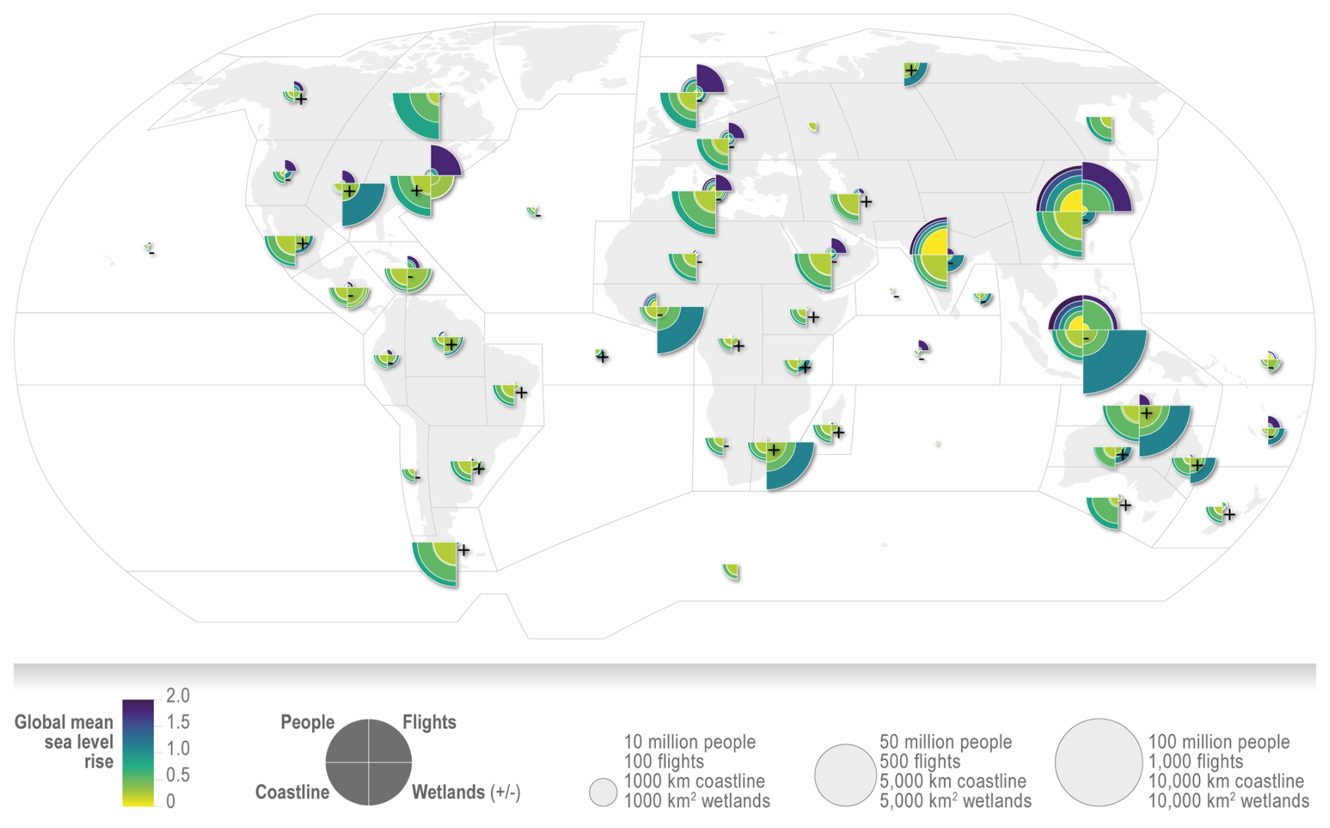
Figure 1Map of risks for cities and settlements by the sea according to IPCC regions, extracted from IPCC AR6 (Glavovic et al., 2022). The map shows risks to people (number of people at risk from a 100-year coastal flood event; Haasnoot et al., 2021), risks of loss of coastal land (length of coast with more than 100 m retreat; Vousdoukas et al., 2020), risks to the built environment (airports at risk indicated by expected annual number of flights disrupted by coastal flooding; Yesudian and Dawson, 2021), and risks to wetlands (± indicates positive or negative area change; Schuerch et al., 2018). Risks are reported against the global mean sea level (GMSL) rise relative to 2020 (in metres), depending on data availability.
Numerical ocean models can be used to provide both consistent retrospective datasets of sea level changes over the global, regional, or coastal ocean and forecasts of sea level change (Melet et al., 2021). Both can be used to support adaptation to sea level rise (Alvarez Fanjul et al., 2022). Due to sea level rise, the frequency of extreme sea levels at the coast will increase (Kirezci et al., 2020), and associated impacts on population and economic damages will, too, without further adaptation (Fig. 1). Short-term (a few days) sea level forecasts provided by ocean forecasting systems are necessary information to feed early warning systems (EWSs) for coastal floods. EWSs are integrated systems allowing a real-time monitoring of potential natural hazards, issuing warnings when a natural hazard is measured or forecasted, and informing stakeholders (e.g. civil protection agencies, regional and local authorities, ports, environmental agencies) as part of an integrated risk assessment cycle to mitigate risks. EWSs were found to be an efficient adaptation measure by providing more than a 10-fold return on investment (Global Commission on Adaptation, 2019).
Monitoring of sea level change over past decades provides the historical baseline for quantifying sea level rise and extremes and their return periods, along with synoptic sea level variability in a broader sense. Ocean (wave) reanalyses combine ocean (wave) model dynamics with in situ and satellite observations through data assimilation. As such, reanalyses provide a consistent view of the ocean in space and time and across variables, accounting for observation information and dynamics. The reliability of ocean reanalyses has increased over the last decade (Forget et al., 2015; Lellouche et al., 2021; Storto et al., 2019; Zuo et al., 2019).
Numerical modelling systems are the backbone of ocean and wave hindcasts (modelling past evolutions over the last decades), reanalyses (hindcasts constrained by observations through routine assimilation of in situ and space observations), and forecasts (over a few days to weeks). Such models are solving the equations governing ocean and wave dynamics and are often constrained by observations through assimilation of in situ and satellite observations (Alvarez Fanjul et al., 2022). They provide a synoptic spatial and temporal monitoring of the ocean.
Regarding sea level forecasts, both storm surge models based on shallow-water equations (Fujiang et al., 2022) and ocean general circulation models (OGCMs) based on primitive equations (Ciliberti et al., 2022) are used. In terms of model grids, both structured and unstructured grids can also be used. Other details on model equations, discretization methods, grid types, coordinates, data assimilation techniques, and inventory of operational systems are available in Alvarez Fanjul et al. (2022).
Wind waves also contribute to mean and extreme sea levels through wave setup and to the fluctuation of the water line at the coast through wave runup (Dodet et al., 2019). Wind wave sea level contributions are estimated from wave models (Aouf et al., 2022). In addition, non-linear interactions between mean sea level, tides, storm surges, and waves act on the total sea level at the coast (Chaigneau et al., 2023; Idier et al., 2019).
The accuracy of numerical models in forecasting sea levels is limited by several factors (e.g. discussion in Irazoqui Apecechea et al., 2023), such as the accuracy of the atmospheric forcing forecasts (especially so for the storm surge and wave components of total sea level changes at the coast), the tidal forcings for regional to coastal systems, the representation of bathymetry, the lack of representation of non-linear interactions between sea level components (mean-sea level-tides-surges-wave), and the limitations of the ocean and wave models themselves (e.g. model numerics, resolution, lack of some coastal processes such as wetting and drying, the river–estuary–ocean continuum).
2.1 Storm surge models
Storm surge models, also called hydrodynamic models here, are usually based on shallow-water equations. They are the most common tools to simulate the generation and propagation of storm surges due to atmospheric surface pressure and winds, thereby providing water levels and velocities (e.g. SELFE, SCHISM, POM, Delft3D, ADCIRC, GTSM, MIKE21, TuFlow, ROMS, FVCOM, SHYFEM) (Fujiang et al., 2022; Ciliberti et al., 2022). They can also incorporate astronomical tides. In these models, shallow-water equations are often discretized based on unstructured meshes with either finite-volume methods or finite-element methods. Unstructured grids allow seamless modelling from the open ocean to the coastal ocean using a spatially variable resolution with finer resolution in the coastal zones (Fig. 2), which enhances the simulation of coastal processes (e.g. Federico et al., 2017; Ferrarin et al., 2018; Toomey et al., 2022; Zhang et al., 2016). Mostly used in their 2D, barotropic version, such models are computationally fast and can be used over continent-wide regions or the global ocean to produce hindcasts (Fernández-Montblanc et al., 2020, 2019) reaching up to 1.25 km resolution at the coast (Muis et al., 2020) and operational forecasts (NOAA, 2023) and to produce tidal atlases (Lyard et al., 2021). However, barotropic hydrodynamic models do not simulate changes in mean sea level due to baroclinic effects, although this contribution can be substantial even for extreme sea levels, such as in micro-tidal or non-stormy regions.
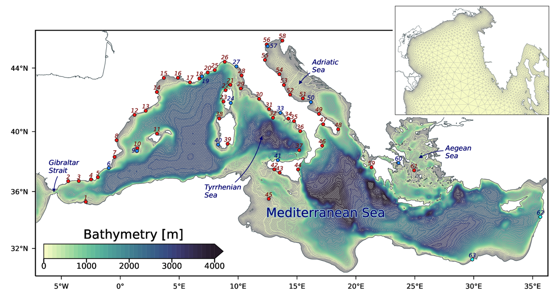
Figure 2An example of an unstructured barotropic ocean model and bathymetry (here, from the System of HydrodYnamic Finite Element Modules (SHYFEM); Bajo et al., 2023). The inset is a zoom of the grid in the northern Adriatic Sea. The blue and red dots mark the locations of tide gauges.
There are also 3D baroclinic hydrodynamic models, which are able to solve additional physical processes, such as the gradients of seawater-density-induced changes in mean sea level (e.g. steric sea level), and lead to more accurate sea level measurements with even greater impacts on currents (Ye et al., 2020). Adding baroclinicity in a global barotropic operational model can lead to significant improvements in predictions of extreme water levels (Wang et al., 2022).
In storm surge models, the calibration of bottom friction is especially important. Such systems can assimilate different sources of observations notably to provide more accurate initial conditions for their forecasts and increase forecast skills over short lead times. Observations assimilated in storm surge models include sea surface height from tide gauges, for higher frequency and coastal processes, and/or from satellite altimetry, for longer-period processes. Operational storm surge forecasting systems have been implemented in many countries, based on different types of storm surge models (Fujiang et al., 2022).
2.2 Ocean general circulation models
The 3D baroclinic ocean general circulation models, based on primitive equations (Ciliberti et al., 2022), are widely used in operational oceanography (e.g. NEMO, HYCOM, ROMS, MOM, MITgcm, CROCO, FVCOM, SHYFEM, SCHISM, FESOM, MPAS) for ocean circulation forecasting systems, also providing a valuable solution for forecasting sea level changes (Irazoqui Apecechea et al., 2023; Melet et al., 2021). More complex and expensive than storm surge models previously described, they can simulate mean sea level changes due to ocean circulations, along with tides and storm surges when forced by surface atmospheric pressure and wind, coherently with other ocean state variables (e.g. 3D temperature, salinity, ocean currents). Operational systems also usually assimilate observations. Of particular importance for the representation of sea level changes are the assimilation of satellite altimetry data, to directly constrain total sea level; in situ profiles of temperature and salinity, to constrain the steric and dynamic component of sea level; and satellite gravimetry data, to constrain the mass component of global mean sea level (GMSL) rise. The assimilation of satellite altimetry exerts a major constraint on such forecasting systems to increase their skills (Hamon et al., 2019; Le Traon et al., 2017).
Due to the Boussinesq approximation in primitive-equation models, the global mean (or spatial average in an area-limited regional model) steric sea level change cannot be explicitly simulated. However, this time-dependent scalar can be diagnosed from the temperature and salinity fields (Griffies and Greatbatch, 2012) and added to simulated sea level changes. Spatial gradients of steric sea level changes are directly simulated in primitive-equation models through changes in temperature and salinity inducing differences in density and circulation changes. Another limitation stems from the use of a constant, uniform gravity field and the approximation of spherical geopotential surfaces. This approximation does not allow us to represent the changes in the Earth's gravity and rotation or solid-Earth deformation (the so-called GRD effects; Gregory et al., 2019; Mitrovica et al., 2011) due to the transfer of water from land to the ocean (e.g. melting mountain glaciers, mass loss of ice sheets, changes in land water storage), which contribute to regional departures from the global mean sea level rise.
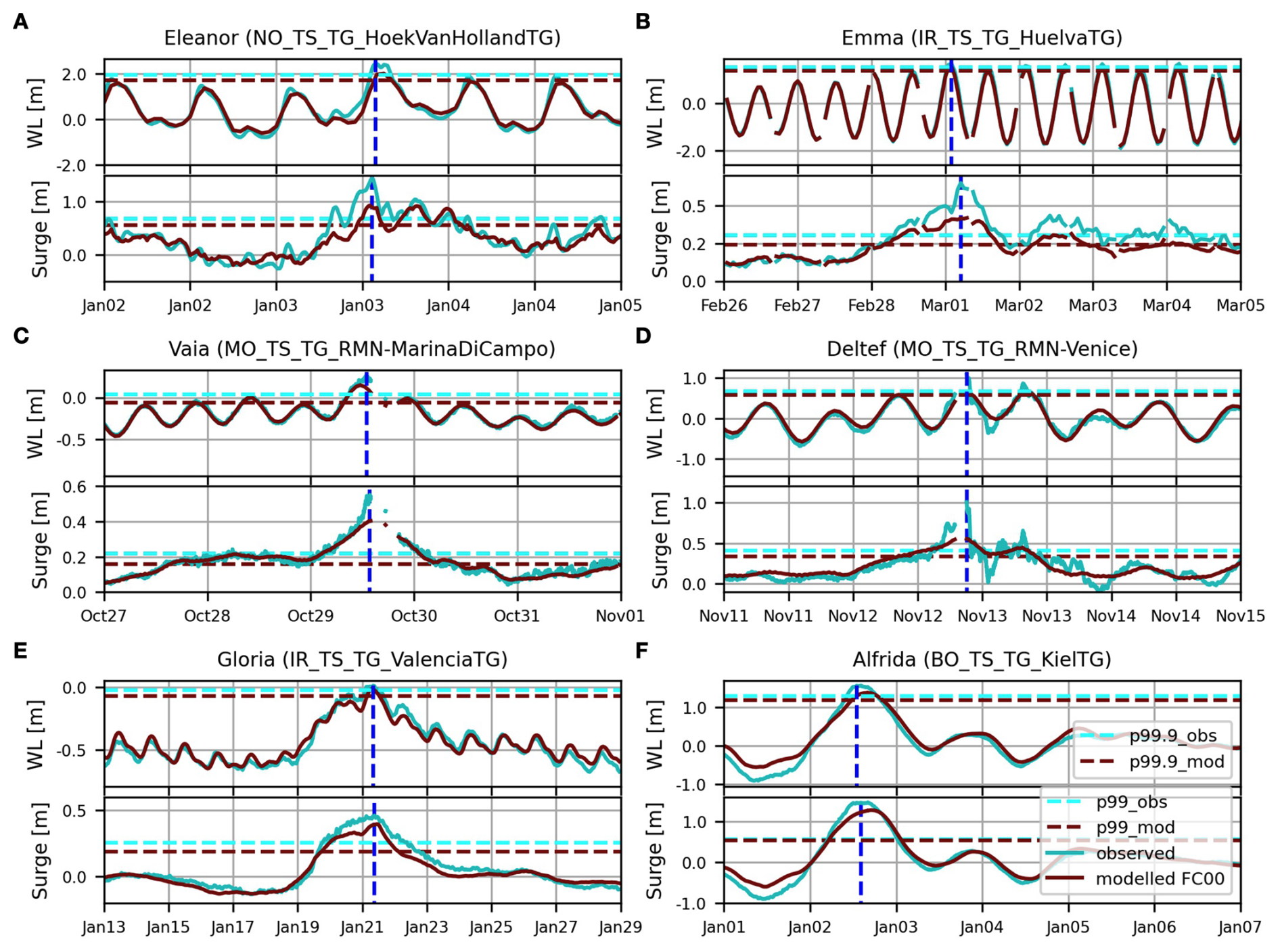
Figure 3Simulated (in dark red) and tide gauge (TG) (in blue) sea levels (including mean sea level, tides, surge) and surges observed during a selection of extreme events in Europe. (a) Hoek Van Holland TG (Eleanor, 2018), (b) Huelva TG (Emma, 2018), (c) Marina Di Campo TG (Vaia, 2018), (d) Venice TG (Detlef, 2019), (e) Valencia TG (Gloria, 2020), (f) Kiel TG (Alfrida, 2019). Water level and surge percentile thresholds for the model and observations are shown in the corresponding colours as horizontal dashed lines. The vertical blue line denotes the observed peak time for the plotted component. Extracted from Irazoqui Apecechea et al. (2023).
As hydrodynamical models, operational OGCMs can be used to forecast sea level changes from global scales (E.U. Copernicus Marine Service Information, 2024) to coastal scales (Fig. 3). For instance, the skills of the regional operational ocean forecasting systems (OOFSs) of the Copernicus Marine Service covering European seas to forecast sea level extremes were evaluated (Irazoqui Apecechea et al., 2023), showing satisfactory performance, with an underprediction of peak magnitudes of both extreme sea levels and their surge components. For these OOFSs, forecast skills are stable for the first 3 d of the forecasts but decrease at forecast lead times of 4 d and longer, demonstrating the suitability of the systems for early warning applications. The possible sea level processes included in these regional models must be taken into consideration when comparing/validating with local tide gauge data. This may require additional pre-processing of tide gauge data to deal with higher-frequency sea level oscillations often recorded at very local scales and contributing to local extremes. Adding sea ice effects in a global operational model was shown to improve total water level forecasts (Wang and Bernier, 2023).
Regional or global operational ocean forecasting systems can also be used to downscale sea level changes at more coastal scales for local applications. Regional ocean models can have higher resolutions than global ocean models (e.g. ranging from 2 to 12 km for European seas in the Copernicus Marine Service for operational forecasting systems as of July 2023) and benefit from ocean models adapted to the regional dynamics and from the representation of additional processes.
Global and regional reanalysis can be used to provide a baseline over the past decades of sea level changes, when tide gauges are sparsely located along coastlines. Reanalyses benefiting from data assimilation capture the spatial variability in altimetry-derived sea level trends (Lellouche et al., 2021). Since altimetric observations capture sea level trends due to land ice mass loss and land water storage changes, in addition to trends due to sterodynamic sea level changes (Gregory et al., 2019), a processing of the altimetric data to be assimilated in OGCMs or a processing of the sea level represented in the model needs to be performed. For instance, in the global ocean high-resolution reanalysis provided by the Copernicus Marine Service (GLORYS12; Lellouche et al., 2021), a global mean sea level trend is added at each time step to the modelled dynamic sea level, prior to data assimilation. This added GMSL signal is composed of the diagnosed global mean steric sea level change and of a barystatic (land-ice-related as in Gregory et al., 2019) sea level trend.
2.3 Ensemble forecasting
Deterministic solutions provided by numerical models can be complemented by multi-model systems, stochastic approaches, and ensemble estimates. Ensemble forecasting allows us to account for different sources of uncertainties that arise from errors in e.g. the initial or boundary conditions, the atmospheric forcing or forcing functions, the physics or parameterization of the numerical model, the bathymetry, and the spatial- or temporal-resolution limitations. Forecast skills tend to decrease with increasing forecast lead times, as errors grow. It is therefore possible to provide probabilistic forecasts that better support coastal decision-makers by adding a confidence interval to the forecasted variable. This can be achieved in different ways (Alvarez Fanjul et al., 2022), both for hindcasts and short-term forecasts, taking into account (or not) observational data to determine model performance and decrease model errors.
A first immediate approach is considering existing operational forecasts over an overlapping area to build a multi-model system. This is possible today thanks to the number of general ocean circulation operational systems with a reliable coastal sea level solution, such as those of the Copernicus Marine Service (global and regional marine forecasting systems (MFCs)). The good performance of these models for coastal sea level (Irazoqui Apecechea et al., 2023) can complement the solution provided by storm surge forecasting systems run at national level. This is the approach followed by Ports of Spain, which combines its 2D barotropic storm surge forecasting system (Nivmar; Alvarez-Fanjul et al., 2001) with the different MFCs covering the Spanish coast since 2012 (Pérez-Gómez et al., 2021). Today, the system, named ENSURF, combines Nivmar with two regional MFCs, IBI-MFC (Aznar et al., 2016) and MedFS (Clementi et al., 2021). It makes use of the Bayesian model averaging (BMA) statistical technique (Beckers et al., 2008) for validation of the different models with tide gauge data in near-real time and provides the outperforming mean and spread of sea level forecasts at the Spanish ports (Fujiang et al., 2022).
Thanks to the increased computational resources, storm surge ensemble forecasts can rely today on a larger number of members. A more recent multi-model and higher-resolution approach is in place today for the Adriatic Sea, combining up to 19 sea level and wave models as described in Ferrarin et al. (2020). Very often, the storm surge ensemble members are obtained by forcing the same model with an ensemble of meteorological forecasts providing different wind and sea level pressure fields, which account for most of the uncertainty during a storm. In this case, the model uncertainty will reflect the one of the meteorological forcing. As an example, the ECMWF ensemble (Molteni et al., 1996) is used for storm surge operational forecasts in the North Sea (Flowerdew et al., 2010, 2013). This approach was also applied for sea level forecasting in Venice by Mel and Lionello (2014).
Machine learning techniques can also be used to improve model performance locally and account for high-frequency sea level oscillations. This is the approach followed by Rus et al. (2023) in the northern Adriatic, where traditional ensemble forecasting is replaced by computationally efficient machine-learning-based ensemble models, trained with tide gauge data to improve the probabilistic forecast and account for seiches at a single location.
Sea level forecasting is especially important at the coasts due to impacts on population and assets. Many operational systems are already in place, based on different model types, assimilating different observations (Capet et al., 2020; Fujiang et al., 2022; Ciliberti et al., 2022). Storm surge numerical modelling started in the 1950s, and operational oceanography with OGCMs combined with data assimilation largely developed in the 1980s and 1990s with the availability of satellite observations and increase in computational capacities. Despite decades of developments of such modelling systems and satisfactory forecast skills at short lead time, forecasting sea level changes at the coast at spatiotemporal scales relevant for decision-making remains challenging. This is notably due to the wealth of processes driving sea level changes at the coast (Woodworth et al., 2019) and to the short scales of coastal zone dynamics.
No data sets were used in this article.
AM led the writing of the article. All authors participated in the review and revision of the article.
The contact author has declared that none of the authors has any competing interests.
Publisher's note: Copernicus Publications remains neutral with regard to jurisdictional claims made in the text, published maps, institutional affiliations, or any other geographical representation in this paper. While Copernicus Publications makes every effort to include appropriate place names, the final responsibility lies with the authors.
The authors thank the reviewers for their constructive criticism and are grateful to Stefania Ciliberti and Enrique Alvarez Fanjul for their unwavering support.
Angelique Melet was supported by grants of the European Union's H2020 programme (project ECFAS, grant no. 101004211, and CoCliCo, grant no. 101003598).
This paper was edited by Jay Pearlman and reviewed by Georg Umgiesser and one anonymous referee.
Abadie, L. M., Jackson, L. P., Murieta, E. Sainz de, Jevrejeva, S., and Galarraga, I.: Comparing urban coastal flood risk in 136 cities under two alternative sea-level projections: RCP8.5 and an expert opinion-based high-end scenario, Ocean Coast. Manage., 193, 105249, https://doi.org/10.1016/j.ocecoaman.2020.105249, 2020.
Alvarez-Fanjul, E., Pérez-Gomez, B., and Rodríguez, I.: Nivmar: a storm surge forecasting system for Spanish waters, Sci. Mar., 65, 145–154, https://doi.org/10.3989/scimar.2001.65s1145, 2001.
Alvarez Fanjul, E., Ciliberti, S., and Bahurel, P.: Implementing Operational Ocean Monitoring and Forecasting Systems, IOC-UNESCO, GOOS-275, https://doi.org/10.48670/ETOOFS, 2022.
Aouf, L., Diaz-Hernandez, G., Babanon, A., Bidlot, J., Staneva, J., and Saulter, A.: Chapter 8: Wave modelling, in: Implementing Operational Ocean Monitoring and Forecasting Systems, edited by: Alvarez Franjul, E., Ciliberti, S., and Bahurel, P., IOC-UNESCO, GOOS-275, https://doi.org/10.48670/ETOOFS, 2022.
Aznar, R., Sotillo, M. G., Cailleau, S., Lorente, P., Levier, B., Amo-Baladrón, A., Reffray, G., and Alvarez Fanjul, E.: Strengths and weaknesses of the CMEMS forecasted and reanalyzed solutions for the Iberia-Biscay-Ireland (IBI) waters, J. Marine Syst., 159, 1–14, https://doi.org/10.1016/j.jmarsys.2016.02.007, 2016.
Bajo, M., Ferrarin, C., Umgiesser, G., Bonometto, A., and Coraci, E.: Modelling the barotropic sea level in the Mediterranean Sea using data assimilation, Ocean Sci., 19, 559–579, https://doi.org/10.5194/os-19-559-2023, 2023.
Beckers, J. V. L., Sprokkereef, E., and Roscoe, K. L.: Use of Bayesian model averaging to determine uncertainties in river discharge and water level forecasts, Proceedings 4th International Symposium on Flood Defence: Managing Flood Risk, Reliability and Vulnerability, 6–8 May 2008, Toronto, Ontario, Canada, 2008.
Capet, A., Fernàndez, V., She, J., Dabrowski, T., Umgiesser, G., Staneva, J., Mészáros, L., Campuzano, F., Ursella, L., Nolan, G., and El Serafy, G.: Operational Modeling Capacity in European Seas – An EuroGOOS Perspective and Recommendations for Improvement, Front. Mar. Sci., 7, 129, https://doi.org/10.3389/fmars.2020.00129, 2020.
Chaigneau, A. A., Law-Chune, S., Melet, A., Voldoire, A., Reffray, G., and Aouf, L.: Impact of sea level changes on future wave conditions along the coasts of western Europe, Ocean Sci., 19, 1123–1143, https://doi.org/10.5194/os-19-1123-2023, 2023.
Ciliberti, S., Ayoub, N., Chanut, J., Cirano, M., Delamarche, A., De Mey-Frémaux, P., Drévillon, M., Drillet, Y., Hewitt, H., Masina, S., Tanajura, C., Vervatis, V., and Wan, L.: Chapter 5: Circulation modelling, in: Implementing Operational Ocean Monitoring and Forecasting Systems, edited by: Alvarez Franjul, E., Ciliberti, S., and Bahurel, P., IOC-UNESCO, GOOS-275, https://doi.org/10.48670/ETOOFS, 2022.
Clementi, E., Aydogdu, A., Goglio, A. C., Pistoia, J., Escudier, R., Drudi, M., Grandi, A., Mariani, A., Lyubartsev, V., Lecci, R., Cretí, S., Coppini, G., Masina, S., and Pinardi, N.: Mediterranean Sea Physical Analysis and Forecast (CMEMS MED-Currents, EAS6 system) (Version 1), Copernicus Monitoring Environment Marine Service (CMEMS) [data set], https://doi.org/10.25423/CMCC/MEDSEA_ANALYSISFORECAST_PHY_006_013_EAS6, 2021.
Dodet, G., Melet, A., Ardhuin, F., Bertin, X., Idier, D., and Almar, R.: The Contribution of Wind-Generated Waves to Coastal Sea-Level Changes, Surv. Geophys., 40, 1563–1601, https://doi.org/10.1007/s10712-019-09557-5, 2019.
E.U. Copernicus Marine Service Information (CMEMS): Global Ocean Physics Analysis and Forecast, Marine Data Store (MDS) [data set], https://doi.org/10.48670/moi-00016, 2024.
Federico, I., Pinardi, N., Coppini, G., Oddo, P., Lecci, R., and Mossa, M.: Coastal ocean forecasting with an unstructured grid model in the southern Adriatic and northern Ionian seas, Nat. Hazards Earth Syst. Sci., 17, 45–59, https://doi.org/10.5194/nhess-17-45-2017, 2017.
Fernández-Montblanc, T., Vousdoukas, Ciavola, P., Voukouvalas, E., Mentaschi, L., Breyiannis, G., Feyen, L., and Salamon, P.: Towards robust pan-European storm surge forecasting, Ocean Model., 133, 129–144, https://doi.org/10.1016/j.ocemod.2018.12.001, 2019.
Fernández-Montblanc, T., Vousdoukas, M. I., Mentaschi, L., and Ciavola, P.: A Pan-European high resolution storm surge hindcast, Environ. Int., 135, 105367, https://doi.org/10.1016/j.envint.2019.105367, 2020.
Ferrarin, C., Bellafiore, D., Sannino, G., Bajo, M., and Umgiesser, G.: Tidal dynamics in the inter-connected Mediterranean, Marmara, Black and Azov seas, Prog. Oceanogr., 161, 102–115, https://doi.org/10.1016/j.pocean.2018.02.006, 2018.
Ferrarin, C., Valentini, A., Vodopivec, M., Klaric, D., Massaro, G., Bajo, M., De Pascalis, F., Fadini, A., Ghezzo, M., Menegon, S., Bressan, L., Unguendoli, S., Fettich, A., Jerman, J., Ličer, M., Fustar, L., Papa, A., and Carraro, E.: Integrated sea storm management strategy: the 29 October 2018 event in the Adriatic Sea, Nat. Hazards Earth Syst. Sci., 20, 73–93, https://doi.org/10.5194/nhess-20-73-2020, 2020.
Flowerdew, J., Horsburgh, K., Wilson, C., and Mylne, K.: Development and evaluation of an ensemble forecasting system for coastal storm surges, Q. J. Roy. Meteor. Soc., 136, 1444–1456, https://doi.org/10.1002/qj.648, 2010.
Flowerdew, J., Mylne, K., Jones, C., and Titley, H.: Extending the forecast range of the UK storm surge ensemble, Q. J. Roy. Meteor. Soc., 139, 184–197, https://doi.org/10.1002/qj.1950, 2013.
Forget, G., Campin, J.-M., Heimbach, P., Hill, C. N., Ponte, R. M., and Wunsch, C.: ECCO version 4: an integrated framework for non-linear inverse modeling and global ocean state estimation, Geosci. Model Dev., 8, 3071–3104, https://doi.org/10.5194/gmd-8-3071-2015, 2015.
Fujiang, Y., Byrne, D., Dong, J., Pérez Gomez, B., and Liu, S.: Chapter 7: Storm surge modelling, in: Implementing Operational Ocean Monitoring and Forecasting Systems, edited by: Alvarez Franjul, E., Ciliberti, S., and Bahurel, P., IOC-UNESCO, GOOS-275, https://doi.org/10.48670/ETOOFS, 2022.
Glavovic, B. C., Dawson, R., Chow, W., Garschagen, M., Haasnoot, M., Singh, C., and Thomas, A.: Cross-Chapter Paper 2: Cities and Settlements by the Sea, in: Climate Change 2022: Impacts, Adaptation and Vulnerability. Contribution of Working Group II to the Sixth Assessment Report of the Intergovernmental Panel on Climate Change, edited by: Pörtner, H.-O., Roberts, D. C., Tignor, M., Poloczanska, E. S., Mintenbeck, K., Alegría, A., Craig, M., Langsdorf, S., Löschke, S., Möller, V., Okem, A., and Rama, B., Cambridge University Press, Cambridge, UK and New York, NY, USA, 2163–2194, https://doi.org/10.1017/9781009325844.019, 2022.
Global Commission on Adaptation: Adapt Now: A Global Call for Leadership on Climate Resilience, World Resources Institute, Washington, DC, https://openknowledge.worldbank.org/handle/10986/3236 (last access: 13 September 2024), 2019.
Gregory, J. M., Griffies, S. M., Hughes, C. W., Lowe, J. A., Church, J. A., Fukimori, I., Gomez, N., Kopp, R. E., Landerer, F., Le Cozannet, G., Ponte, R. M., Stammer, D., Tamisiea, M. E., and van de Wal, R. S. W.: Concepts and Terminology for Sea Level: Mean, Variability and Change, Both Local and Global, Surv. Geophys., 40, 1251–1289, https://doi.org/10.1007/s10712-019-09525-z, 2019.
Griffies, S. and Greatbatch, R.: Physical processes that impact the evolution of global mean sea level in ocean climate models, Ocean Model., 51, 37–72, https://doi.org/10.1016/j.ocemod.2012.04.003, 2012.
Haasnoot, M., Winter, G., Brown, S., Dawson, R. J., Philip J. Ward, P. J., and Eilander, D.: Long-term sea-level rise necessitates a commitment to adaptation: a first order assessment, Clim. Risk Manag., 34, 100355, https://doi.org/10.1016/j.crm.2021.100355, 2021.
Haigh, I. D., Pickering, M. D., Green, J. A. M., Arbic, B. K., Arns, A., Dangendorf, S., Hill, D. F., Horsburgh, K., Howard, T., Idier, D., Jay, D. A., Jänicke, L., Lee, S. B., Müller, M., Schindelegger, M., Talke, S. A., Wilmes, S., and Woodworth, P. L.: The Tides They Are a-Changin': A comprehensive review of past and future non-astronomical changes in tides, their driving mechanisms and future implications, Rev. Geophys., 58, e2018RG000636, https://doi.org/10.1029/2018RG000636, 2020.
Hamon, M., Greiner, E., Remy, E., and Le Traon, P. Y.: Impact of multiple altimeter data and mean dynamic topography in a global analysis and forecasting system, J. Atmos. Ocean. Tech., 36, 1255–1266, https://doi.org/10.1175/JTECH-D-18-0236.1, 2019.
Idier, D., Bertin, X., Thompson, P., and Pickering, M. D.: Interactions Between Mean Sea Level, Tide, Surge, Waves and Flooding: Mechanisms and Contributions to Sea Level Variations at the Coast, Surv. Geophys., 40, 1603–1630, https://doi.org/10.1007/s10712-019-09549-5, 2019.
Irazoqui Apecechea, M., Melet, A., and Armaroli, C.: Towards a pan-European coastal flood awareness system: Skill of extreme sea-level forecasts from the Copernicus Marine Service, Front. Mar. Sci., 9, 1091844, https://doi.org/10.3389/fmars.2022.1091844, 2023.
Kirezci, E., Young, I. R., Ranasinghe, R., Muis, S., Nicholls, R. J., Lincke, D., and Hinkel, J.: Projections of global-scale extreme sea levels and resulting episodic coastal flooding over the 21st century, Sci. Rep., 10, 11629, https://doi.org/10.1038/s41598-020-67736-6, 2020.
Legeais, J.-F., Meyssignac, B., Faugère, Y., Guerou, A., Ablain, M., Pujol, M.-I., Dufau, C., and Dibarboure, G.: Copernicus Sea Level Space Observations: A Basis for Assessing Mitigation and Developing Adaptation Strategies to Sea Level Rise, Front. Mar. Sci., 8, 704721, https://doi.org/10.3389/fmars.2021.704721, 2021.
Lellouche, J.-M., Greiner, E., Bourdalleì-Badie, R., Garric, G., Melet, A, Drevillon, M., Bricaud, C., Hamon, M., Le Galloudec, O., Regnier, C., Candela, T., Testut, C.-E., Gasparin, F., Ruggiero,, G., Benkiran, M., Drillet, Y., and Le Traon, P. Y.: The Copernicus global ° oceanic and sea ice GLORYS12 reanalysis, Front. Earth Sci., 9, 698876, https://doi.org/10.3389/feart.2021.698876, 2021.
Le Traon, P. Y., Dibarboure, G., Jacobs, G., Martin, M., Remy, E., and Schiller, A.: Use of satellite altimetry for operational oceanography. Satellite Altimetry over Oceans and Land Surfaces, edited by: Stammer, D. and Cazenave, A., CRC Press, 581–604, ISBN 9781315151779, 2017.
Lyard, F. H., Allain, D. J., Cancet, M., Carrère, L., and Picot, N.: FES2014 global ocean tide atlas: design and performance, Ocean Sci., 17, 615–649, https://doi.org/10.5194/os-17-615-2021, 2021.
Mel, R. and Lionello, L.: Storm Surge Ensemble Prediction for the City of Venice, Weather Forecast., 29, 1044–1057, https://doi.org/10.1175/WAF-D-13-00117.1, 2014.
Melet, A., Buontempo, C., Mattiuzzi, M., Salamon, P., Bahurel, P., Breyiannis, G., Burgess, S., Crosnier, L., Le Traon, P.-Y., Mentaschi, L., Nicolas, J., Solari, L., Vamborg, F., and Voukouvalas, E.: European Copernicus Services to Inform on Sea-Level Rise Adaptation: Current Status and Perspectives, Front. Mar. Sci., 8, 703425, https://doi.org/10.3389/fmars.2021.703425, 2021.
Mitrovica, J. X., Gomez, N., Morrow, E., Hay, C., Latychev, K., and Tamisiea, M. E.: On the robustness of predictions of sea level fingerprints: On predictions of sea-level fingerprints, Geophys. J. Int., 187, 729–742, https://doi.org/10.1111/j.1365-246X.2011.05090.x, 2011.
Molteni, F., Buizza, R., Palmer, T. N., and Petroliagis, T.: The ECMWF Ensemble Prediction System: Methodology and validation, Q. J. Roy. Meteor. Soc., 122, 73–119, https://doi.org/10.1002/qj.49712252905, 1996.
Morim, J., Hemer, M., Wang, X. L., Cartwright, N., Trenham, C., Semedo, A., Young, I., Bricheno, L., Camus, P., Casas-Prat, M., Erikson, L., Mentaschi, L., Mori, N., Shimura, T., Timmermans, B., Aarnes, O., Breivik, Ø., Behrens, A., Dobrynin, M., Menendez, M., Staneva, J., Wehner, M., Wolf, J., Kamranzad, B., Webb, A., Stopa, J., and Andutta, F.: Robustness and uncertainties in global multivariate wind-wave climate projections, Nat. Clim. Change, 9, 711–718, https://doi.org/10.1038/s41558-019-0542-5, 2019.
Muis, S., Irazoqui Apecechea, M., Dullaart, J., de Lima Rego, J., Madsen, K. S., Su, J., Yan, K., and Verlaan, M.: A High-Resolution Global Dataset of Extreme Sea Levels, Tides, and Storm Surges, Including Future Projections, Front. Mar. Sci., 7, 263, https://doi.org/10.3389/fmars.2020.00263, 2020.
Neumann, B., Vafeidis, A. T., Zimmermann, J., and Nicholls, R. J.: Future Coastal Population Growth and Exposure to Sea-Level Rise and Coastal Flooding – A Global Assessment, PLOS ONE, 10, e0118571, https://doi.org/10.1371/journal.pone.0118571, 2015.
NOAA: NOAA Global Surge and Tide Operational Forecast System 2-D (STOFS-2D-Global), NOAA, https://registry.opendata.aws/noaa-gestofs (last access: 27 July 2024), 2023.
Pérez-Gómez, B., García-León, M., García-Valdecasas, J., Clementi, E., Mösso Aranda, C., Pérez-Rubio, S., Masina, S., Coppini, G., Molina-Sánchez, R., Muñoz-Cubillo, A., García Fletcher, A., Sánchez González, J. F., Sánchez-Arcilla, A., and Álvarez Fanjul, E.: Understanding Sea Level Processes During Western Mediterranean Storm Gloria, Front. Mar. Sci., 8, 647437, https://doi.org/10.3389/fmars.2021.647437, 2021.
Rus, M., Fettich, A., Kristan, M., and Ličer, M.: HIDRA2: deep-learning ensemble sea level and storm tide forecasting in the presence of seiches – the case of the northern Adriatic, Geosci. Model Dev., 16, 271–288, https://doi.org/10.5194/gmd-16-271-2023, 2023.
Schuerch, M., Spencer, T., Temmerman, S., Kirwan, M. L., Wolff, C., Lincke, D., McOwen, C. J., Pickering, M. D., Reef, R., Vafeidis, A. T., Hinkel, J., Nicholls, R. J., and Brown, S.: Future response of global coastal wetlands to sea-level rise, Nature, 561, 231–234, https://doi.org/10.1038/s41586-018-0476-5, 2018.
Storto, A., Masina, S., Simoncelli, S., Iovino, D., Cipollone, A., Drevillon, M., Drillet, Y., von Schuckmann, Parent, L., Garric, G., Greiner, E., Desportes, C., Zuo, H., Balmaseda, M. A., and Peterson, K. A.: The added value of the multi-system spread information for ocean heat content and steric sea level investigations in the CMEMS GREP ensemble reanalysis product, Clim. Dynam., 53, 287–312, https://doi.org/10.1007/s00382-018-4585-5, 2019.
Toomey, T., Amores, A., Marcos, M., and Orfila, A.: Coastal sea levels and wind-waves in the Mediterranean Sea since 1950 from a high-resolution ocean reanalysis, Front. Mar. Sci., 9, 991504, https://doi.org/10.3389/fmars.2022.991504, 2022.
Vousdoukas, M. I., Ranasinghe, R., Mentaschi, L., Plomaritis, T. A., Athanasiou, P., Luijendijk, A., and Feyen, L.: Sandy coastlines under threat of erosion, Nat. Clim. Change, 10, 260–263, https://doi.org/10.1038/s41558-020-0697-0, 2020.
Wang, P. and Bernier, N. B.: Adding sea ice effects to a global operational model (NEMO v3.6) for forecasting total water level: approach and impact, Geosci. Model Dev., 16, 3335–3354, https://doi.org/10.5194/gmd-16-3335-2023, 2023.
Wang, P., Bernier, N. B., and Thompson, K. R.: Adding baroclinicity to a global operational model for forecasting total water level: Approach and impact, Ocean Model., 174, 102031, https://doi.org/10.1016/j.ocemod.2022.102031, 2022.
Woodworth, P. L., Melet, A., Marcos, M., Ray, R. D., Wöppelmann, G., Sasaki, Y. N., Cirano, M., Hibbert, A., Huthnance, J. M., Monserrat, S., and Merrifield, M. A.: Forcing Factors Affecting Sea Level Changes at the Coast, Surv. Geophys., 40, 1351–1397, https://doi.org/10.1007/s10712-019-09531-1, 2019.
Ye, F., Zhang, Y. J., Yu, H., Sun, W., Moghimi, S., Myers, E., Nunez, K., Zhang, R., Wang, H. V., and Roland, A.: Simulating storm surge and compound flooding events with a creek-to-ocean model: Importance of baroclinic effects, Ocean Model., 145, 101526, https://doi.org/10.1016/j.ocemod.2019.101526, 2020.
Yesudian, A. N. and Dawson, R. J.: Global analysis of sea level rise risk to airports, Climate Risk Management, 31, 100266, https://doi.org/10.1016/j.crm.2020.100266, 2021.
Zhang, Y. J., Stanev, E., and Grashorn, S.: Unstructured-grid model for the North Sea and Baltic Sea: validation against observations, Ocean Model., 97, 91–108, https://doi.org/10.1016/j.ocemod.2015.11.009, 2016.
Zuo, H., Balmaseda, M. A., Tietsche, S., Mogensen, K., and Mayer, M.: The ECMWF operational ensemble reanalysis–analysis system for ocean and sea ice: a description of the system and assessment, Ocean Sci., 15, 779–808, https://doi.org/10.5194/os-15-779-2019, 2019.