the Creative Commons Attribution 4.0 License.
the Creative Commons Attribution 4.0 License.
 | 02 Jun 2025 | OPSR | Chapter 3.2
A description of ocean forecasting applications around the globe
Jennifer Veitch
Enrique Alvarez-Fanjul
Arthur Capet
Stefania Ciliberti
Mauro Cirano
Emanuela Clementi
Fraser Davidson
Ghada el Serafy
Guilherme Franz
Patrick Hogan
Sudheer Joseph
Svitlana Liubartseva
Yasumasa Miyazawa
Heather Regan
Katerina Spanoudaki
Operational oceanography can be considered the backbone of the blue economy: it offers solutions that can support multiple UN Sustainable Development Goals by promoting the sustainable use of ocean resources for economic growth, livelihoods and job creation. Given this strategic challenge, the community worldwide has started to develop science-based and user-oriented downstream services and applications that use ocean products as provided by forecasting systems as main input. This paper provides examples of stakeholder support tools offered by such applications and includes sea state awareness, oil spill forecasting, port services, and fishing and aquaculture. Also emphasized is the important role of ocean literacy and citizen science to increase awareness of and education about these critical topics. Snapshots of various applications in key world ocean regions, within the framework of the OceanPrediction Decade Collaborative Centre (DCC), are illustrated, with emphasis given on their level of maturity. Fully operational examples can be used as inspiration for export to other areas.
- Article
(3111 KB) - Full-text XML
- BibTeX
- EndNote


The World Bank defines the blue economy as the sustainable use of ocean resources for economic growth and improved livelihoods and jobs while preserving the health of the ecosystem. The blue economy has the potential to help address many of the UN Sustainable Development Goals including no poverty, zero hunger, affordable and clean energy, decent work and economic growth, climate action, and life below water. Various programmes and associated actions of the UN Decade of Ocean Science for Sustainable Development (https://oceandecade.org/, last access: 4 May 2025) are designed to provide the science to support the blue economy as well as ensuring the resilience of both marine ecosystems and coastal populations. A key objective of several of the programmes is the development of improved coast-to-ocean forecasts and predictions and, most essentially, their uptake by and usefulness to coastal stakeholders. To achieve this and to support the development of a sustainable blue economy, the operational oceanography community should be able to support the development of downstream applications in which model data are transformed into tailored information for end users. These applications are intended to create applied solutions to various societal, environmental and scientific challenges from which both public entities and private companies can benefit and actively take part in the implementation of the so-called “value chain”. The ETOOFS (Expert Team on Operational Ocean Forecasting Systems) Guide on Implementing Operational Ocean Monitoring and Forecasting Systems (Alvarez Fanjul et al., 2022) provides a thorough overview of the need for downstream services as well as examples of advanced systems that include portals for the dissemination of sea state awareness (e.g. https://data.marine.copernicus.eu/, last access: 4 May 2025); oil spill forecasting (e.g. MOTHY (http://www.meteorologie.eu.org/mothy/, last access: 4 May 2025), WITOIL (https://www.witoil.com/, last access: 4 May 2025); MEDSLIK-II (https://www.medslik-ii.org/, last access: 4 May 2025)); port services (e.g. SAMOA (https://www.puertos.es/, last access: 4 May 2025) and Aquasafe (https://hidromod.com/?s=aquasafe, last access: 4 May 2025)); voyage planning (e.g. VISIR (https://www.visir-model.net/, last access: 4 May 2025)); and fishing and aquaculture.
In this chapter, we provide only some examples of existing downstream services for eight of the nine regions identified by the OceanPrediction Decade Collaborative Centre (DCC): the West Pacific and Marginal Seas of South and East Asia, Indian Seas, African Seas, Mediterranean and Black Sea, North East Atlantic, South and Central America, North America, and the Arctic. The Antarctic region is not included in this review of downstream services due to the lack of services provided there. The distribution of the regions is based on both the UNEP (United Nations Environment Programme) and the GOOS Regional Alliances (GRAs), with some clustering.
The regional sections have been prepared by each of the regional teams of the OceanPrediction DCC (https://www.unoceanprediction.org/en/about/community, last access: 4 May 2025), and, though not comprehensive, each provides a flavour of the needs in each region as well as some of the downstream application services developed to meet them and their maturity levels. The downstream applications have been broadly grouped as follows: extremes, hazards and safety; natural resources and energy; shipping, ports and navigation; and climate adaptation. Specific contributions for each grouping may differ per region. Extremes, hazards and safety refers to all extreme events, both offshore (such as marine heat waves) and coastal (such as storm surges); marine pollution (that includes water quality and oil spills); and search-and-rescue (SAR) operations. Natural resources and energy refers to all downstream applications associated with the sustainable exploitation of marine resources (we include aquaculture); renewable energy, tourism and recreation; and conservation efforts. Shipping, ports and navigation includes operational support for research activities (including cruise-track optimization as well as deploying equipment), and climate adaptation focuses on longer-timescale tools that are provided to support coastal and ecosystem resilience. The examples provided are primarily based on public sector forecasting systems and services, with a few exceptions. The OceanPrediction DCC Atlas of Services (https://www.unoceanprediction.org/en/atlas, last access: 4 May 2025), will contain a more complete list of downstream services in each of the regions.
In the West Pacific and its marginal sea region, development of operational ocean forecast systems was initiated by governmental operational/research agencies related to meteorology, hydrography and oceanography in several countries including Australia, China, Japan, South Korea, Indonesia and Aotearoa / New Zealand. Several downstream services led by governmental operational agencies have been developed that focus on support of search-and-rescue operations and preparation for marine disasters. Recently, some industrial applications for fishery and shipping operations have been developed based on close collaborations between scientists and targeted users.
As a one-stop shop for the provision of downstream applications with support from the Ocean Decade Collaborative Centre on Ocean–Climate Nexus and Coordination (DCC-OCC) and the Ocean to Climate Seamless Forecasting (OSF) programme, China is developing a COAST Toolkit as a knowledge hub and information platform for decision-makers and scientists to obtain information services for action. The toolkit aims to address the challenge of marine and coastal disaster prevention and resources development based on ocean solutions. There are six main modules included in the COAST Toolkit: Module 1 – Marine disasters prevention and mitigation; Module 2 – Maritime navigation safety, including in the Arctic; Module 3 – Coastal ecosystem health; Module 4 – Integrated coastal zone management; Module 5 – Blue economy support; Module 6 – Ocean literacy. COAST will deliver predictive capacities, services and products for marine and coastal systems. The products will link field data with complex models and applications with visualization.
Examples of various downstream applications in the West Pacific and Marginal Seas of South and East Asia are provided in the sections below.
2.1 Extreme, hazards and safety
Aotearoa / New Zealand's Moana Project (https://www.moanaproject.org/, last access: 4 May 2025) has developed an interactive particle tracking tool (https://www.moanaproject.org/particle-tracker, last access: 4 May 2025) on their web portal that allows users to release particles, plankton or larvae into either hindcast or forecast models, based on global or their regionally optimized simulations. This tool supports not only offshore safety operations and oil spill response but also fisheries.
The Ocean and Climate Early Warning Universal System (OCEANUS), developed by the First Institute of Oceanography (FIO) in China, with the support of the Ocean to Climate Seamless Forecasting System (OSF) Ocean Decade programme, is a similar example of a platform that supports various early-warning downstream applications. The OCEANUS platform automatically integrates multi-source observational data, an operational forecast system developed by FIO (the Global Ocean Environment Forecast System; for more information refer to Qiao et al., 2019), automatic post-processing of forecast results, and real-time transmission and release of forecast products. The forecast system supports three downstream applications on the OCEANUS platform: the Global Coral Reef Bleaching Early Warning System, Global Maritime Search and Rescue Forecast System and Global Oil Spill Response System. Detailed information can be found in the OCEANUS brochure at https://osf-un-ocean-decade.com/pdfPreview?id=6401 (last access: 4 May 2025).
The Malaysian Meteorological Department (MMD; also known as Met Malaysia) ocean forecasting system, developed in collaboration with the FIO, provides 5 d forecasts of surface wave heights, wave period, sea level, ocean currents, sea temperature and salinity for the Malaysian and adjacent seas. These forecasts are operationally disseminated through a web portal hosted by the MMD (Fig. 1) and provide early warning to ensure the safety and well-being of marine socio-economic activities in Malaysia through, for example, oil spill and search-and-rescue responses.
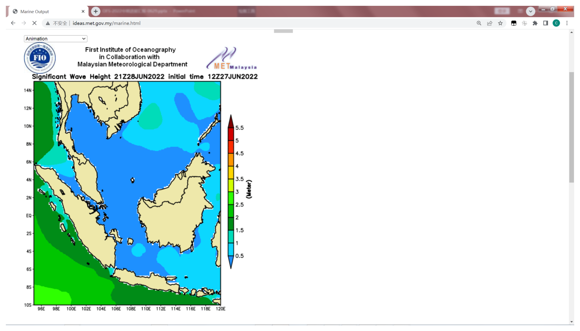
Figure 1A snapshot of the Malaysian Meteorological Department's web portal on which the FIO–MMD ocean forecasting system is disseminated.
Below some examples specific to particular applications within the West Pacific and Marginal Seas of South and East Asia are highlighted.
2.1.1 Search and rescue
The Korea Ocean Observing and Forecasting System (KOOFS) led by the Korea Hydrographic and Oceanography Agency (KHOA) provides forecast information required for SAR operations (Republic of Korea/OceanPredict, 2020). The Japan Coast Guard operates a support system for SAR using an ocean forecasting product provided from the Japan Meteorological Agency (JMA) (Japan Coast Guard, 2025). While also providing ongoing support for SAR, the Australian Bluelink forecast system assisted in the high-profile case of the disappearance of Malaysia Airlines flight MH370 (Schiller et al., 2019).
2.1.2 Oil spills
Oil spill tracking models utilizing ocean forecasting products are also developed in several countries including China, South Korea and Japan. For example, an oil spill tracking model coupled with an ocean circulation–tide–wave coupling model was applied for evaluating potential contamination caused by an accident of an oil tanker Sanchi in 2018 around the East China Sea (Qiao et al., 2019). The Indonesian Agency for Meteorology, Climatology and Geophysics (Badan Meteorologi, Klimatologi, dan Geofisika, BMKG) is operating downscaled model products for forecasting storm surge and coastal inundation hazards around Jakarta and other port cities in Indonesia (Ramdhani, 2019). Coupling of high-resolution coastal ocean current, wave and river flood models is required for forecasting in real-time and evaluating potential inundation locations in the target cites.
2.1.3 Marine heat waves
The Moana Project in Aotearoa / New Zealand aims to improve understanding of ocean circulation, connectivity and marine heat waves to provide information that supports Aotearoa / New Zealand's seafood industry. It provides an operational marine heat wave indicator (https://www.moanaproject.org/marine-heatwave-forecast, last access: 4 May 2025), as well as sea surface temperature anomalies, based on their regionally optimized operational forecast model.
2.2 Natural resources and energy
Decadal timescale reanalysis products of ocean and wave models are used for assessing feasibility of ocean renewable energy development around Japan coastal seas and their adjacent Asian seas (Webb et al., 2020). Reliable estimation of the renewable energy potential associated with waves, ocean currents and thermal energy requires sufficiently long time duration periods for adequately considering the possible time-dependent natural variability. They have evaluated minimum time duration periods of 20 years for wave and 10 years for ocean current and thermal energy conversion around Japan. The high-resolution wave (NOAA WAVEWATCH III) and ocean and tidal current forecast (JAMSTEC JCOPE) models driven by the atmospheric reanalysis forcing were used for calculation of the energy potential reanalysis.
In some cases, ocean forecasting data (JCOPE) have been used for marine environmental assessment for exploration of seafloor resources in the northwestern Pacific such as cobalt-rich ferromanganese crusts (Nagao et al., 2018). Direct velocity measurement using acoustic Doppler current profilers (ADCPs) in deep oceans presents some technical challenges, and combined use of ocean forecasting data and ADCP measurement could be effective for the reliable assessment of ocean current variability around the targeted areas (Nagao et al., 2018).
In Japan, industrial/commercial use of ocean forecasting is being developed for supporting trade ship navigation (Sato and Horiuchi, 2022) and fishery activities (e.g. https://oceaneyes.co.jp/en/home-2, last access: 4 May 2025). An early-warning system of the abrupt occurrences of strong currents damaging set-net fisheries is operated under intensive collaboration between universities and local fishery agencies in Japan (Hirose et al., 2017). Close collaboration among universities, research institutes, instrument companies and fishers demonstrates significant enhancement of marine observation networks through the exchange of ocean forecasting information and in situ observations among them (Nakada et al., 2014; Hirose et al., 2019). In Oceanian seas, Bluelink (https://www.csiro.au/bluelink/, last access: 4 May 2025) forecast products are widely utilized for maritime transport providers, fishing industries and tourism operators.
2.3 Shipping, ports and navigation
2.3.1 Defence
The Royal Australian Navy ingests forecast data produced by Bluelink into their System for Acoustic Geo-environmental Exemplification (SAGE) to calculate range predictions (Schiller et al., 2019). These calculate, for a specific ship, the distance they could expect to detect a submarine or be detected by a submarine, based on the current ocean conditions, estimated from the forecasts provided.
2.3.2 Sea level
Sea level is vital for port operations. The Australian Bureau of Meteorology (BOM) provides aggregated sea-level forecasts based on the Bluelink operational systems, superimposed with other factors that influence coastal sea level. Additionally, these forecasts have proven most beneficial when incorporated into existing decision tools that include the BOM river flood warning interface where ocean boundary conditions are improved by the forecasts (Schiller at al., 2019).
2.4 Climate adaptation
CSIRO; BOM; and the Australian Government's Department of Climate Change, Energy, the Environment and Water have produced a web portal (https://climatechangeinaustralia.gov.au/en/, last access: 4 May 2025) that provides climate information, projections, tools and data to inform decision-making related to climate change in Australia. The portal incorporates both observational datasets and climate projections.
Operational ocean forecast systems and downstream services in the Indian Ocean have several stakeholders, including government agencies, maritime industries, research institutions and the public. The operational oceanographic services for the Indian Seas underwent significant progress during the past 25 years. These functional systems have several components, which include observation networks designed to collect and research teams to analyse and disseminate oceanographic data; assimilate the data to numerical models; and provide forecasts to support decision-making, improve safety and enhance the understanding of the Indian Ocean environment. The Indian Ocean forecasting system, operational at the Indian National Centre for Ocean Information Services (INCOIS) helps several regional small island countries in the Indian Ocean under regional alliances such as Regional Integrated Multi-Hazard Early Warning System for Africa and Asia (RIMES) and the Colombo Security Conclave (CSC). INCOIS serves as the Regional Specialized Meteorological Centre (RSMC) for global numerical ocean and wave prediction for the Indian region as per the WMO mandate. RSMC services are provided to the region through a web portal, which can be accessed at (https://incois.gov.in/oceanservices/rsmc_ocean.jsp, last access: 4 May 2025), with an example of their ocean and wave prediction service provided in Fig. 2. Provided below are some key components and applications of these systems.
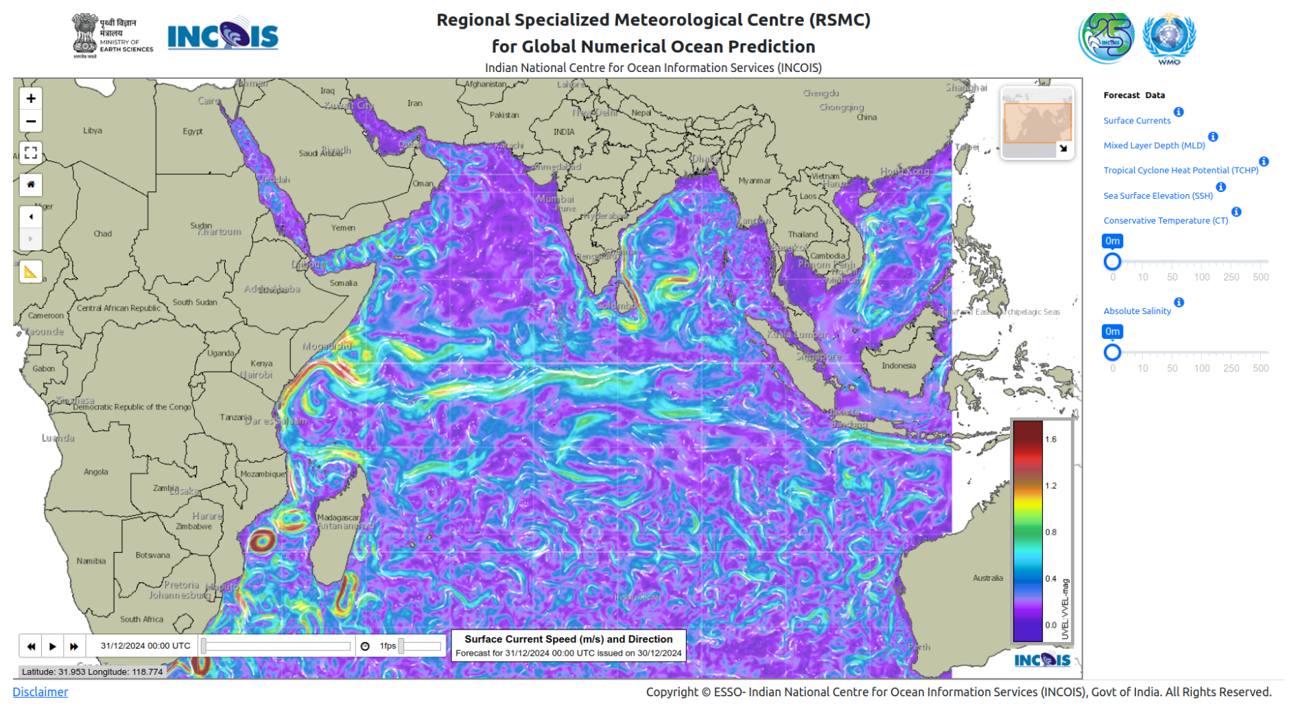
Figure 2Web interface of the RSMC for numerical ocean prediction (left) and the same for wave prediction (right).
3.1 Extremes, hazards and safety
3.1.1 Search and Rescue Aid Tool (SARAT)
The Search And Rescue Aid Tool (SARAT; https://sarat.incois.gov.in/sarat/home.jsp, last access: 4 May 2025) is developed for facilitating individuals/vessels in distress in the shortest possible time. This has been initiated and developed under the “Make in India” programme. The tool uses model ensembles that account for uncertainties in the initial location and last known time of the missing object to locate the person or object with high probability – the movement of the lost objects is governed mainly by currents and winds.
3.1.2 Oil spill trajectory prediction
The oil spill prediction system (OOSA; https://incois.gov.in/portal/osf/oosa.jsp, last access: 4 May 2025) operational at INCOIS works based on the GNOME model, which uses ocean currents from an ocean general circulation model and winds from an atmospheric general circulation model to simulate the Lagrangian drift of oil spills, which needs initial location of spill and quantity of the oil and type of oil if available for producing movement of oil under the influence of winds and currents.
3.1.3 Marine heat wave advisory services (MHAS)
Marine heat waves refer to the anomalous (above the 90th percentile) increase in sea surface temperature compared to the historical (past 30 years) values persistent over 5 consecutive days. These heat waves have a profound impact on marine ecology and fisheries and marine biodiversity. In view of the environmental significance of marine heat waves, India started generating marine heat wave advisories and made them available as a service through the web portal (https://incois.gov.in/portal/mhw/index.jsp, last access: 4 May 2025). It also issues special bulletins during excessive and persistent heat waves.
3.2 Natural resources and energy
3.2.1 Potential fishing zone (PFZ) advisories
Using satellite-derived sea surface temperature (SST) and chlorophyll and tapping the habitat preference of fishes, advisories to fishers have been provided through a wide range of communication channels such as a web portal (https://incois.gov.in/MarineFisheries/PfzAdvisory, last access: 4 May 2025), Short Message Service (SMS), radio, mobile applications and electronic display boards for the past couple of decades, and there is positive feedback from fishers about this service. As the fisher community are of diverse ethnic background and speak multiple languages, the services are provided as multilingual texts. There are about 700 000 registered users for this service at present.
3.2.2 Coral Bleaching Alert System (CBAS)
Coral reefs play a pivotal role in marine ecosystems and are vital for the habitats of flora and fauna in the ocean. Ecologically, coral reefs are significant as they provide a conducive environment for several marine species and thereby contribute to the biological productivity in the ocean. However, coral reefs are sensitive to SST, and sustained thermal stress can cause severe damage to the coral reefs. They get bleached proportionate to the intensity and duration of the thermal stress. India has developed a satellite-based operational system for assessing the thermal stress on corals from satellite SST corroborated with ground truth through field examination of coral damage. This service is for assessing the degree of damage caused to the coral environments within the Indian Seas and is made available through a web portal (https://incois.gov.in/portal/coralwarning, last access: 4 May 2025).
3.3 Shipping, ports and navigation
Small Vessel Advisory Services (SVAS)
The Small Vessel Advisory and Forecast Services (SVAS; https://incois.gov.in/portal/osf/SVA.jsp, last access: 4 May 2025) system is an innovative impact-based advisory and forecast service system for small vessels operating in the Indian coastal waters. SVAS warns users against potential zones where vessel overturning can take place, 10 d in advance. This warning system is based on a “boat safety index” (BSI) derived from wave model forecast outputs, such as significant wave height, wave steepness, directional spread and the rapid development of wind sea.
3.4 Climate adaptation
Climate indices
Climate indices such as El Niño/La Niña conditions and Indian Ocean Dipole conditions are computed based on model simulations and made available through the web portal (https://incois.gov.in/portal/ElNino, last access: 4 May 2025). The status of the above-mentioned interannual climate modes is regularly updated and provided to the end users alongside the indices for the past 12 months. These indices are widely used by policy-makers and the agricultural sector as they have a significant impact on Indian monsoon and annual rainfall patterns in the region.
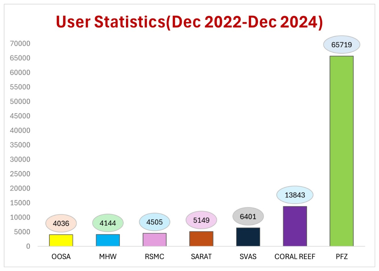
Figure 3User statistics generated from selected services of provided to the Indian Seas region.
While the development of operational ocean forecast systems and downstream services, optimized for African regional seas and coastal regions is limited, it is ongoing (Uba et al., 2020; de Vos et al., 2021; Hart-Davis and Backeberg, 2023), and various strategies exist to support stakeholders. In the simplest example, local met offices use global services to package alerts for subscribed users via text messages or emails, while others add value to global services by customizing solutions for stakeholders. The most advanced services are in the north of the continent, where downstream applications benefit from the advanced Mediterranean Sea operational systems (Cirano et al., 2025 in this report); in the Red Sea area, where an optimized regional system has been developed (Cirano et al., 2025; Hoteit et al., 2021); and in the far south, where a co-designed decision support portal is well established for stakeholders. Examples of approaches to various downstream applications will be provided below.
A more cohesive, regional approach to the provision of operational information to support marine and coastal operations in Africa has been established by GMES (Global Monitoring for Environment and Security; https://au.int/GMESAfrica, last access: 4 May 2025) and Africa via MarCOSIO (Marine and Coastal Operations for Southern Africa and the Indian Ocean; https://marcosio.org/, last access: 4 May 2025) and MarCNoWA (Marine and Coastal Areas Management in North and West Africa; https://gmes.rmc.africa/, last access: 4 May 2025). These platforms currently make use of global services for earth observations as well as marine forecast products that in some cases are optimized for local conditions. Linked to MarCOSIO is the National Oceans and Coastal Information Management System (OCIMS; https://ocims.environment.gov.za/, last access: 4 May 2025), developed by the South African Department of Forestry, Fisheries and the Environment (DFFE) in collaboration with the Council for Scientific and Industrial Research (CSIR). OCIMS provides customized decision support tools that include coastal flood hazard, operations at sea, fisheries and aquaculture, integrated vessel tracking, marine spatial planning, water quality, and marine predators. These tools are co-designed with the key stakeholder groups in annual stakeholder engagement workshops that bring together the developers as well as the end users that include the aquaculture industry, National Sea Rescue Institute (NSRI), marine authorities and the Navy, and municipalities. These tools currently make use of operational satellite products, optimized for the South African coastline, as well as global forecast models that are not locally optimized. Limited area operational forecast models are in development (https://somisana.ac.za, last access: 4 May 2025) and will be integrated into the OCIMS DeSTs within the next year.
4.1 Extremes, hazards and safety
4.1.1 Oil spills
In the case of an oil spill in African waters, global services are generally called upon to assist with the mitigation effort. For example, in the case of the devastating oil spill in the Indian Ocean on 25 July 2020, when the MV Wakashio bulk carrier ran aground off Mauritius (Seveso et al., 2021), Mercator Ocean International provided Météo-France with ocean current forecasts to feed the MOTHY pollutant drift model, and the CMCC (Euro-Mediterranean Centre on Climate Change) used Copernicus Marine Service near-real-time products like forecasted currents and ECMWF winds to forecast the weathering and transport of the oil slick.
The SOMISANA team in South Africa have developed a pre-emptive approach in which they release a “virtual” oil spill at each of the ship-to-ship refuelling locations within their high-resolution bay-scale models. They use a simple Lagrangian particle tracking approach to allow the hypothetical oil spill to be tracked 5 d into the future. Additionally, their oil spill tracking functionality, developed using the OpenDrift software, allows for seamless tracking between the global and coastal/bay-scale forecast models and can be launched on demand.
The iRED-M1 system (Hoteit et al., 2021), developed at the King Abdullah University of Science and Technology, provides an ocean–wave–atmosphere coupled forecast system with dedicated web servers for interactive visualization, analytics and queries. These forecasts are used mainly for oil-spill trajectories as well as providing assessments on extreme weather and wave conditions.
4.1.2 Storm surge
Storm surge information was highlighted as being important all of the time in eastern African countries due to the frequent flooding events that occur in association with cut-off low events and tropical cyclones and that have serious ecosystem, socio-economic and health impacts (Mather and Stretch, 2012; Ravela et al., 2013; Cambaza et al., 2019; Molua et al., 2020; Singh and Schoenmakers, 2023). In South Africa and Mozambique the meteorological services and a local municipality have developed downscaled storm surge models (Cirano et al., 2025) in order to provide early warnings to coastal stakeholders. These forecasts are provided either on an operational web portal (e.g. https://marine.weathersa.co.za/Forecasts_Surge.html, last access: 4 May 2025) and/or by early warnings that come in the form of emails or text messages to subscribed users that include port authorities, fishing communities, NGOs and consultants.
4.1.3 Search and rescue
The South African OCIMS provides an Operations at Sea decision support tool (https://www.ocims.gov.za/coastops/, last access: 4 May 2025) that operationally disseminates marine weather information that includes NOAA's GFS wind and wave forecasts, historic winds and waves based on the downscaled atmospheric models that are run by the South African Weather Service (SAWS). As an additional tool that has been custom-built for and requires a login from the National Sea Rescue Institute (NSRI), it allows the user to use global wind, wave and current forecasts to optimize search domains.
4.2 Natural resources and energy
4.2.1 Fisheries' management
Despite fisheries being consistently identified as the most essential coastal activity requiring operational forecast services throughout the African Seas regions, relatively few downstream applications exist to support the industry. One example is ABALOBI (https://abalobi.org/, last access: 4 May 2025) that is a South African-based enterprise that aims to support the sustainability of small-scale fishing communities through technology. ABALOBI provides a mobile application that is designed for users that span the value chain from small-scale fishers to consumers. The application provides forecast information about marine weather (from the NCEP Global Forecast System) and also notification about red tide events (derived from Copernicus Marine Service satellite information) but also provides various logging and business management tools. ABALOBI supports the traceability of seafood, fully documented fisheries, fair and transparent supply chains, and community cohesion and entrepreneurship (2018–2019 impact report available at https://drive.google.com/file/d/1wbi0PPDOr8oZS_b0LMJs5PFy37tOAiv5/view, last access: 4 May 2025).
The fundamental triad of enrichment, concentration and retention along with the transport of fish eggs and larvae from their spawning to nursery areas is critical for the sustainability of the high productivity that supports the lucrative South African fishing industry. Furthermore, connectivity between marine protected areas is an essential component in the health and longevity of marine ecosystems. To this end, many studies have made use of numerical ocean models to force Lagrangian particle experiments in order to understand these transport and retention processes and their various impacts (Pfaff et al., 2022; Heye, 2021).
4.2.2 Aquaculture
In order to reduce the impact of harmful algal blooms (HABs) on the South African aquaculture industry such as the extreme event that occurred on the southwest of the Western Cape in 2017 and that caused the mortality of ∼ 250 t of farmed abalone (Groom et al., 2019), OCIMS has incorporated a HAB decision support tool (https://www.ocims.gov.za/hab/app/, last access: 4 May 2025). This operational tool provides a matrix of probability of HABs occurring in key locations along the South African coastline. The spatial and temporal extent of the bloom is captured by remotely sensed chlorophyll data that are provided by the EUMETSAT Data Store (Sentinel-3 OLCI and SLSTR) and the Copernicus Marine Service (Global Ocean Colour chl-a), and chl-a estimates are optimized for high biomass bloom water types (Smith et al., 2018).
4.3 Shipping, ports and navigation
The South African Weather Service provides regionally optimized wind and wave forecasts to support port operations. The CSIR's Vessel Motion Forecast Tool (Troch et al., 2024) utilizes numerical models to predict long-period wave climates and subsequent moored ship motions, providing port authorities with important information regarding vessel stability. This tool enables port operators to assess the suitability of different vessel sizes at berths for both current and forecasted wave conditions, directly improving operational efficiency and safety. By linking numerical models and providing an intuitive user interface, the tool delivers actionable insights into potential berth-specific issues, allowing for proactive planning and minimization of downtime.
4.4 Climate adaptation
Digital Earth Africa (DE Africa; https://www.digitalearthafrica.org/platform-resources/services/coastlines, last access: 4 May 2025) significantly supports climate adaptation along African coastlines through its Coastlines application. This tool leverages satellite imagery and data analysis to monitor coastal erosion, inundation, and shoreline changes, critical factors influenced by climate change. By providing time-series data, DE Africa helps identify vulnerable areas and track the impact of rising sea levels and increased storm surges. While the Coastlines application primarily utilizes satellite data, it can be enhanced by incorporating predictive models. For example, hydrodynamic models forecasting wave action and sea-level rise can be integrated to project future coastal changes. Additionally, climate models that predict changes in rainfall patterns and storm frequency can inform the interpretation of observed coastal shifts, allowing for more robust risk assessments and adaptation planning. This integration of data and models enables informed decision-making for coastal management, infrastructure planning and community resilience in the face of a changing climate.
During the last decades, the constant evolution of increasingly accurate operational forecasting systems in particular in the Mediterranean Sea and, to a lower extent, in the Black Sea, from regional to local and coastal scales, providing systematic information of the essential ocean variables, has led to the consolidation and to the development of a wide range of scientific and societal applications in the area.
Mediterranean and Black Sea analysis and forecast operational numerical products, such as the ones delivered through the Copernicus Marine Service (https://marine.copernicus.eu, last access: 4 May 2025) by the MED (https://marine.copernicus.eu/about/producers/med-mfc, last access: 4 May 2025; Coppini et al., 2023) and BLK (https://marine.copernicus.eu/about/producers/bs-mfc, last access: 4 May 2025; Ciliberti et al., 2022) MFCs (Monitoring and Forecasting Centres) are essential to provide a 3-dimensional state of the sea, including currents, temperature, salinity, mixed layer thickness, sea level, wind waves and biogeochemistry to support many downstream applications and activities.
Considering that the two basins are characterized by a large variety of complex physical processes occurring on a wide range of spatiotemporal scales, it is required to develop models that can reproduce specific ocean variables' evolutions and to focus on specific processes representation (from wind-driven and thermohaline circulation to water mass formation, coastal processes such as upwelling and storm surge, and extreme and fast events such as medicanes). Following all these needs, the Mediterranean and Black Sea communities have been implementing models based on different codes and parameterizations, properly designed to solve specific problems.
Several downstream applications developed and implemented in the Mediterranean and Black Sea are presented hereafter, considering climate change studies, oil spill, ship routing, search and rescue, marine litter, ports, water quality, fish and larvae dispersion, and fisheries' and aquaculture management, as well as adaptation and management strategies. Most of the listed applications are described in a recent book from Schroeder and Chiggiato (2022), who edited an introductory guide on the oceanography of the Mediterranean Sea and in the ETOOFS (Expert Team on Operational Ocean Forecasting Systems) Guide by Alvarez Fanjul et al. (2022).
5.1 Extremes, hazards and safety
5.1.1 Oil spills
Oil spill models are forced by meteo-oceanographic forecasting products providing ocean currents, wind and waves which should be available on a regular basis. Several oil spill models are operated in the Mediterranean and Black Sea, and specific forecasting systems have also been implemented in areas of oil spill emergencies such as those presented in Cucco et al. (2012). Moreover, oil spill modelling in harbour and port areas has been developed, such as in the Port of Taranto in south Italy (Liubartseva et al., 2021), the Limassol port areas in Cyprus (Zodiatis et al., 2024), the Port of Tarragona in Spain (Morell Villalonga et al., 2020) and the Spanish harbours through the SAMOA project launched by Puertos del Estado (PdE). Additionally, MEDSLIK (Zodiatis et al., 2021) and MEDSLIK-II (De Dominicis et al., 2013), Lagrangian oil spill models for short-term forecasting, were applied in various areas. Several decision support systems (DSSs) dedicated to oil slick emergencies and predictions in the Mediterranean Sea have been developed, such as the French MOTHY (Daniel, 1996) drift system, the Italian WITOIL (Where Is The Oil) multi-model DSS and the MEDESS4MS (Zodiatis et al., 2016; Sorgente et al., 2020). The OILTOX Lagrangian oil spill model adapted for the Black Sea environment for oil spill transport and fate has been implemented in the northwestern shelf of the Black Sea and Dnieper–Bug Estuary (Brovchenko et al., 2003). The POSEIDON Oil Spill fate and trajectory model is based on the PARCEL model (Pollani et al., 2001), which is able to simulate not only the drift of the oil but also the chemical transformations under the specific environmental conditions.
5.1.2 Search and rescue
An advanced web-based and mobile decision support system for search and rescue (SAR) in the Mediterranean has been developed by Coppini et al. (2016). The system simulates drifting objects at sea, using the met-oceanographic data provided by the Copernicus Marine Service as input. The performance of the service is evaluated by comparing simulations to data from the Italian Coast Guard pertaining to actual incidents in the Mediterranean Sea.
At the national and international level, the National Forecasting Centre of Météo-France provides met-oceanographic support and drift forecasts to assist authorities in charge of search-and-rescue operations. The aforementioned MOTHY system can not only resolve search-and-rescue targets, but it also computes the drift of lost cargo containers (Coppini et al., 2022). The system uses the Copernicus Marine Service data among several forcing fields.
The Hellenic Centre for Marine Research (HCMR) has an agreement with the Hellenic Coast Guard for a SAR service in the Greek seas. The application is developed and hosted at the POSEIDON operational system and provides forecasting of drifting objects.
Currently, under the ever-increasing flow of people trying to reach Europe by crossing the Mediterranean Sea, the efficiency of SAR calls for an enhancement. That requires both improved modelling of drifting objects and optimized search assets' allocation.
In the Adriatic basin, the Slovenian Environment Agency provides met-oceanographic support and drift forecasts to assist authorities in charge of search-and-rescue operations (Ličer et al., 2020); the drift forecasts are based on high-resolution wind forecasts and ocean modelling downscaling of Copernicus Marine Service forecasts for the Mediterranean Sea. The system can resolve search-and-rescue targets, oil spills and cargo containers.
5.1.3 Marine litter
Marine plastic pollution, usually from anthropogenic sources, is increasingly recognized as an emerging threat to the Mediterranean environment, biodiversity, human health and well-being (Schroeder and Chiggiato, 2022). Recently, an important shift has been conducted for the Mediterranean Sea from the spatially uniform distributions of plastic sources to a more realistic representation of land-based and offshore inputs (Liubartseva et al., 2018; Macias et al., 2019; Soto-Navarro et al., 2020; Kaandorp et al., 2020; Tsiaras et al., 2021, 2022a) and for the Black Sea (Miladinova et al., 2020; Stanev and Ricker, 2019; Gonzalez-Fernandez et al., 2022) to identify the accumulation and dissipation of floating litter in such semi-enclosed sea basins.
5.1.4 Water quality
The physical–biogeochemical forecasting system for the northern Adriatic Sea developed in the framework of the CADEAU project (Bruschi et al., 2021) is based on a high-resolution (up to around 750 m) implementation of the MITgcm–BFM coupled model (Cossarini et al., 2017) targeting water quality and eutrophication, and it uses the daily MED MFC products for initialization and to constrain the open boundary.
The trophic index (TRIX) eutrophication assessment indicator has been calculated both on in situ data and with a coupled circulation and biogeochemical numerical modelling system. TRIX is defined by four state variables: chlorophyll-a, oxygen, dissolved inorganic nitrogen and total phosphorus. As an example, the trophic index differences have been computed to evaluate the trophic state of marine waters along the Emilia-Romagna coastline (Italy) and over the whole Adriatic Sea (Fiori et al., 2016).
A relocatable modelling system for describing and forecasting the microbial contamination that affects the quality of bathing waters was implemented at five coastal areas in the Adriatic Sea, which differ in terms of urban, oceanographic and morphological conditions (Ferrarin et al., 2021). The modelling systems are all based on the hydrodynamic finite element model SHYFEM (Umgiesser et al., 2022). Pollution events are mainly triggered by urban sewer outflows during massive rainy events, with relevant negative consequences on the marine environment and tourism and related activities of coastal towns.
5.2 Natural resources and energy
5.2.1 Fish larvae dispersion and fishery and marine aquaculture management
The study of larvae dispersion and regional connectivity and their impact on the structure of species populations and fisheries are generally provided using Lagrangian models (van Sebille et al., 2018; Laurent et al., 2020; Melaku Canu et al., 2020), and in the Mediterranean Sea these have been carried out thanks to the availability of information provided by operational forecasting systems (more information on such applications can be found in Schroeder and Chiggiato, 2022).
Being strongly supported by the policies and initiatives of the European Union, marine aquaculture guarantees food security and reduces the fishing pressure on wild fish stocks. A farm site selection strategy based on an aquaculture suitability index has been developed for the central Mediterranean (Porporato et al., 2020). The index is based on the outputs of eco-physiological models which were forced using time series of sea surface temperature, significant wave height, distance to harbour, current sea uses and cumulative impacts. Tyrrhenian and Ionian coastal areas are found to be more suitable compared to the northern Adriatic and southern Sicilian ones.
Small pelagic fish play a key role in marine food webs, being the trophic link between plankton and larger fish. Given their pronounced sensitivity to environmental changes, end-to-end (physics–plankton–fish) small pelagic fish two-way coupled models (Gkanasos et al., 2021) are unique tools that can be used to study the impact of climate change and fisheries in a single modelling framework.
Coupled hydrodynamic–biogeochemical models can also be used to evaluate the environmental impact of aquaculture waste and investigate the carrying capacity of coastal marine ecosystems (Tsiaras et al., 2022b; Tsagaraki et al., 2011).
Moreover, dynamic energy budget (DEB) models (Hatzonikolakis et al., 2017), forced with hydrodynamic–biogeochemical model output (temperature, Chl-a), can be also implemented to simulate the growth of farmed mussels (Mytilus galloprovincialis) and the potential impact of future climate on their habitat suitability.
5.2.2 Adaptation and management strategies to address harmful algal blooms and jellyfish outbreaks
In recent years, eutrophication phenomena, prompted by global warming and population increase, have stimulated the proliferation of potentially harmful algal taxa, resulting in the prevalence of frequent and intense harmful algal blooms (HABs) in coastal areas of the Mediterranean and Black Sea. Drivers of HABs in coastal areas of the eastern Mediterranean were studied by means of a machine learning methodological approach (Tamvakis et al., 2021). Water temperature has been found to have the most powerful effect on genera's presences.
A jellyfish outbreak forecasting system has been developed for the Mediterranean Sea as a preventive and mitigation tool for citizens and coastal stakeholders, aiming to reduce the jellyfish blooms socio-economic impact in coastal areas through a feasible and powerful management strategy (Marambio et al., 2021). The system explores the Copernicus Marine Service output to predict the jellyfish spatio-temporal distributions.
Previously, high-resolution ocean modelling was applied to examine the transport and stranding of the pelagic stinging jellyfish Pelagia noctiluca on the Ligurian Sea coast (Berline et al., 2013). Jellyfishes were modelled as Lagrangian particles transported by sea currents with a diel vertical migration. Two environmental factors were found to be critical: the position of the northern current and the wind regime.
5.3 Shipping, ports and navigation
5.3.1 Ship routing
The GUTTA-VISIR system is a tactical, global-optimization, single-objective, deterministic model system for ship route planning (Mannarini et al., 2016; Mannarini and Carelli, 2019), which has been implemented in the Mediterranean Sea for several applications (i.e. in the Adriatic Sea, Mannarini et al., 2021) using the analysis and forecast wave and current fields from the MED MFC.
5.3.2 Ports
To respond to the need for information on wind, waves and sea level at the scale of ports and harbour, a Spanish initiative has been developed and operationally implemented called SAMOA-2 (Álvarez Fanjul et al., 2018; Sotillo et al., 2019; García-León et al., 2022) operating in 31 ports. It is an integrated system based on Copernicus Marine data; the service provides daily forecasts of sea-level, circulation, temperature and salinity fields at horizontal resolution that range from 350 m (coastal domains) to 70 m (port domains). Another example implemented along the Spanish coastal waters is provided by PORTUS (https://portus.puertos.es/, last access: 4 May 2025), an early-warning system that employs both the in situ data and the operational forecasts (Álvarez Fanjul et al., 2018).
5.4 Climate adaptation
Over the next few decades, marine heat waves (MHWs) are expected to become more intense, longer and more frequent through anthropogenic warming. Combining high-resolution satellite data and a regional reanalysis, Dayan et al. (2023) have studied MHWs to understand how much each Mediterranean country's exclusive economic zone waters may be affected.
As was stated in the second edition of the Copernicus Marine Service Ocean State Report, ocean deoxygenation is found to be one of the most pernicious, yet under-reported, side effects of human-induced climate change. This problem is particularly acute in the Black Sea, where Capet et al. (2016) have found a decline in the Black Sea oxygen inventory. The reason for this is that atmospheric warming reduces the ventilation of the lower oxic layer by lowering cold intermediate layer formation rates.
The structured provision of mature regional core services and coastal operational forecasting systems in the North East Atlantic (Cirano et al., 2025) enabled a significant deployment of downstream operational services addressing a wide variety of sectors (Fig. 4).
A rich portfolio documenting use cases of downstream services uptake can be found for instance in the Copernicus Marine Service User Uptake portal and the ETOOFS Guide (Alvarez Fanjul et al., 2022). In particular, the EuroGOOS coastal working group roadmap for operational coastal services (El Serafy et al., 2023) details components of the coastal services' value chain in Europe and reviews the status, gaps and steps needed to improve these services and the sustainability of their provision. A full review of the downstream services that are presently active or upcoming in the established sectors of the European blue economy is given in El Serafy et al. (2023). Here we highlight a few examples for selected sectors.
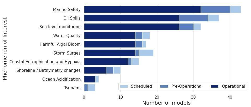
Figure 4Principal characteristics of the Copernicus Marine regional core services for the North East Atlantic region and its relation to its downstream use in sectors.
6.1 Extremes, hazards and safety
6.1.1 Oil spills
Coastal areas with industrial ports and harbours are among the locations most at risk from oil spill pollution, which heavily impacts aquatic life and ecology, coastal infrastructures, and the local economy. This underlines the need for timely and accurate coastal services for operations and disaster response. Oil spill models predicting the fate and the transport of the oil slick have been recently enhanced by downscaling from state-of-art regional models (e.g. Copernicus Marine Service) to very high resolution hydrodynamic models for coastal and harbour areas. A coastal service in water monitoring and oil spill pollution is the OKEANOS project (https://parsec-accelerator.eu/portfolio-items/okeanos/, last access: 4 May 2025), a web-based integrated and intuitive service combining open-source satellite observations (i.e. affordable), artificial intelligence and high-resolution ocean modelling (i.e. accurate). Another example of oil spill forecasting is the drift model MOTHY, developed by Météo-France, which uses ocean currents from the Copernicus Marine Global Ocean Forecast model. This system allows predictions of the possible trajectory of oil spills and estimates the resulting impacts several hours or days in advance. MOTHY has been operational since 1994 and is frequently activated for actual spills or search-and-rescue operations.
6.2 Natural resources and energy
6.2.1 Aquaculture sector
Novel coastal services, including mapping of suitable fishing areas, front detection, marine conditions and scheduler, land pollution, site prospection, spat capture assistance, and contaminant source retrieval, are provided by FORCOAST (https://forcoast.eu/, last access: 4 May 2025) in aquaculture pilot sites, among others, regional waters, the North Sea, the Baltic Sea and the coastal Atlantic Ocean. These services are Copernicus-based services that incorporate Copernicus products, local monitoring data and advanced modelling.
Recent projects that aimed at the co-development with end users and demonstration of harmful algal bloom (HAB) forecasting services as one of the societal needs from the coastal observing and forecasting systems include the FP7 Asimuth (Cusack et al., 2016), H2020 AtlantOS (Cusack et al., 2018) and Interreg Atlantic Area PRIMROSE (https://pml.ac.uk/projects/primrose-predicting-risk-and-impact-of-harmful-eve/, last access: 4 May 2025), all providing near-real-time and forecast information for the aquaculture industry along Europe's Atlantic coast.
Last, but not least, all the data and information produced by operational coastal services may be used in the framework of the Maritime Spatial Planning Directive to identify Allocated Zones for Aquaculture (AZA), following national and international guidelines (e.g. FAO, Macias et al., 2019), as shown by use cases such as AQUAGIS (European Aquaculture Society – ePoster Viewer).
6.2.2 Coastal tourism sector
Various coastal services have been developed following inquiries from the coastal tourism sector. A good example is a tailored product based on the North East Atlantic operational forecasting model in Ireland, developed by the Irish Marine Institute (IMI). Surface currents subsets are provided over five geographical areas around the Irish waters and the English Channel and published in a GRIB format via an ftp site (https://sftp.marine.ie/WebClientNew/Login, accessible only to registered users, last access: 4 May 2025), while ensuring low data volume. The service was developed in collaboration with the sailing community that contacted the IMI to request its development and was notably used during the Fastnet sailing race.
Another Irish example serves beachgoers. The Irish Environmental Protection Agency, in collaboration with Local Authorities and the Department of Housing, Planning and Local Government, runs a web page, https://www.beaches.ie (last access: 4 May 2025), where the latest information on water quality and others is presented for 204 beaches in Ireland. Met Eireann (the Irish national meteorological service) and the Marine Institute contribute to the information provided with current weather and weather forecasts and tidal information, respectively.
Among the services that provide the latest water quality information, the service carried out in the framework of the CADEAU project (Bruschi et al., 2021) provides data and information to assess the potential impact of bacterial pollution sources on bathing waters (as defined in the EU Bathing Water Directive) and help bathing waters' managers in identifying potential sources of impact and planning mitigation measures.
National marine forecasting agencies also serve the coastal tourism sector. The Marine Forecasting Centre of Belgium of the Royal Belgian Institute of Natural Sciences (RBINS) issues 5 d forecasts of the marine conditions in the North Sea twice a day with a high resolution for the Belgian part of the North Sea. These forecasts are used in numerous applications, among them the tourism and leisure industries. Surfers use the application for mobile devices to schedule their sessions for good waves and current conditions.
6.2.3 Renewable energy sector
The renewable energy sector is a prominent player in the blue economy and therefore one of the main potential users of coastal services. Indeed, the EU hosted 70 % of global ocean energy (wave and tidal) installed capacity and 86 % of the world's total installed offshore wind capacity at the end of 2018 (Díaz and Soares, 2020), while jobs in the offshore wind energy sector have multiplied 9-fold in less than 10 years (European Commission, 2020).
Current bottlenecks relating to the large-scale installation of ocean multi-use activities are addressed by the UNITED project (https://www.h2020united.eu/, last access: 4 May 2025), which demonstrates business synergies and benefits of ocean multi-use and provides a roadmap for deployment in future multi-use sites and potential scaling barriers to be addressed through best practices and lessons learnt. Another example of coastal services for the renewable energy sector is Ireland's Marine Renewable Energy Portal (http://www.oceanenergyireland.ie/, last access: 4 May 2025), an online access point for all relevant information and data related to Irish marine renewable energy activity and resources including maps, tools and information for renewable energy site assessment, development and management.
6.3 Shipping, ports and navigation
Coastal information services tailored to the needs of the port sector are provided by the HiSea project (https://hiseaproject.com/, last access: 4 May 2025). The services include early-warning service on potential risk factors issuing alerts on storms, harmful algal blooms, faecal contamination and other hazards regarding pollution accidents to identify the appropriate responses. It provides key performance indicators regarding fish growth rates; environmental conditions or the level of vulnerability to storms for vessels; and information for planning operations including accurate and reliable meteorological, hydrodynamic and water quality forecasts. Further examples of platforms and services for ports are SAMOA and AQUASAFE. The SAMOA service from Puertos del Estado aims to provide high-resolution coastal operational prediction systems in domains such as harbours and nearby coastal waters, for different Spanish port authorities (Sotillo et al., 2019). Similarly, the AQUASAFE platform is operational for all Portuguese ports and in the Port of Santos (Brazil). This platform aims to increase efficiency and safety in port operations, by providing access to real-time and forecast information. It is also used to support aquacultures, inland navigation, irrigation and water utilities.
6.4 Climate adaptation
Climate adaptation is central to the efforts in the North East Atlantic region, where regional core services and operational forecasting systems play a vital role in responding to the impacts of climate change, such as rising sea levels, extreme weather and changes in marine ecosystems. Key systems like the Copernicus Marine Environment Monitoring Service (CMEMS), the European Centre for Medium-Range Weather Forecasts (ECMWF) and the UK Met Office's coastal forecasting systems provide essential data on oceanographic and atmospheric conditions, aiding climate resilience in marine sectors like fisheries, shipping and coastal infrastructure. Initiatives such as the Atlantic Action Plan for a sustainable blue economy, the Interreg North Sea Region Programme, and the European Maritime and Fisheries Fund (EMFF) are focused on enhancing climate resilience, offering solutions like adaptive coastal management, improved early-warning systems and sustainable practices.
The lack of available regional core services and coastal operational forecasting systems in South and Central America (Cirano et al., 2025) makes the development of downstream applications difficult. For instance, very few use case demos are described in the Copernicus Marine Service User Uptake for this region. Normally, downstream applications are only developed in partnership with universities or specialized companies capable of implementing operational systems based on a downscale approach from global models.
Despite the general lack of regional systems for coastal operational forecast systems in South and Central America, smaller-scale services exist and provide useful information for stakeholders. For example, the Baía Digital project (http://www.baia.digital/, last access: 4 May 2025) in Brazil is a portal that integrates various data sources, including regional model forecasts focusing on developing an operational digital platform to provide environmental, social and economic information in the region of Guanabara Bay and its surroundings. The diagnostic and prognostic information generated comes from different sources, such as historical databases, data collection platforms and numerical computational models. Atmospheric and oceanic regional model forecasts represent the marine and atmospheric dynamics of the Guanabara Bay region temporally and spatially. The digital platform has been developed and improved from the interaction between professionals from different areas of science and students from different educational levels, investing in the technical and scientific training of researchers. In addition, extension activities involving students from the school segment will be planned to aim at promoting a scientific culture based on knowledge of Guanabara Bay. The project base is the Laboratory of Computational Methods in Engineering (LAMCE), located in the UFRJ Technological Park, in partnership with other laboratories and teaching and research institutions. The project represents a pioneering effort associated with the regional initiatives of the Atlantic International Research Center (AIR Centre).
In the next sections we showcase a number of bespoke downstream applications based on specific needs.
7.1 Extremes, hazards and safety
7.1.1 Oil spills
The Brazilian Oil Research Group (BROIL) was created in response to the oil spill disaster that impacted more than 3000 km along the north-northeastern Brazilian coastline in 2019, with significant environmental, economic and social impacts. BROIL comprises institutions in Brazil (e.g. UFBA, UFPE, UFRJ, INPE and PUC-Rio) and abroad (e.g. OOM, Portugal; IRD/LEGOS, France; HZG, Germany). BROIL works upon three main pillars: (i) detection, through remote sensing techniques; (ii) control, through a set of hydrodynamic and oil spill models; and (iii) remediation, through a set of biota oil-exposure case studies (Franz et al., 2021). Numerical models used to predict oil spill trajectory include the Regional Ocean Modeling System (ROMS) and the Lagrangian model MEDSLIK-II. Recently, a partnership with the Brazilian Sea Observatory will enable the use of forecasts with higher-resolution hydrodynamic models and prediction of the oil spill trajectory automatically through the MOHID modelling system.
The North Coast Project (http://www.projetocostanorte.eco.br/, last access: 4 May 2025) also integrated research groups with different expertise for the development of a method for determining the vulnerability of mangroves to contamination by oil and for producing knowledge about the Brazilian North Coast, in cooperation among ENAUTA; the Nucleus of Studies in Geochemistry and Marine and Coastal Ecology (NEGEMC) of UERJ; the Laboratory of Computational Methods in Engineering (LAMCE) of COPPE/UFRJ; the Laboratory of Research in Marine Environmental Monitoring (LAPMAR) of UFPA; and PROOCEANO, a Brazilian company of oceanographic technology. The largest continuous area of mangrove forests in the world is found on the north coast of Brazil – located between the states of Maranhão and Pará – totalling around 7400 km2, which corresponds to 4.3 % of the entire area of mangrove forests in the world. The main objective of the project was to determine the vulnerability, sensitivity and susceptibility to oil contamination of the mangroves, based on the development of numerical hydrodynamic models with multiple resolution scales and the use of data assimilation techniques to represent large and mesoscale oceanographic phenomena, with seasonal and interannual variability, to small-scale phenomena with daily variability, such as tidal currents in floodplains. The hydrodynamic modelling results were used as input data for the modelling of the transport and dispersion of oil.
7.1.2 Civil protection
The water level increase due to storm surges can be of the same order of magnitude as tide amplitude along the southeastern Brazilian coast (Franz et al., 2016). Following a downscaling approach, water level forecasts are available to this region, aiming to help civil protection actions. Water level forecasts, as well as data from several tide gauges along the Santa Catarina coast, are available for the public in general on the EPAGRI's company website (https://ciram.epagri.sc.gov.br/index.php/maregrafos/, last access: 4 May 2025). The water level forecasts of high-resolution models (e.g. Babitonga Bay) are also available for port operation. The operational models developed by the Brazilian Sea Observatory initiative (Franz et al., 2021) were updated in collaboration with EPAGRI, considering GEOGloWS (https://geoglows.ecmwf.int/, last access: 4 May 2025) flow predictions for major rivers.
7.1.3 Coastal engineering
Coastal models developed by the Centre for Marine Studies (CEM UFPR) within the scope of the Brazilian Sea Observatory initiative, through the application of the MOHID modelling system, were used to support local companies in the design of submarine outfalls and study of the environmental impacts of bridge construction.
7.2 Natural resources and energy
Aquaculture
Information on water quality in bays and estuaries is essential for planning and managing bivalve mollusc production (e.g. water temperature, microbiological contamination, salinity and nutrients). These parameters are influenced by marine currents, river flows, solar radiation and winds, as well as by urbanization pressure and consequent contamination of water bodies (Cabral et al., 2020). The numerical modelling system MOHID was applied to the main aquaculture production zone of shellfish in Brazil, located in the bay of Ilha de Santa Catarina, with the objective of integrating the range of environmental data in a hydrodynamic and water quality model capable of simulating the variables of greatest interest in the production of bivalve molluscs, thus serving as a powerful management tool (Garbossa et al., 2023; Garbossa et al., 2021; Lapa et al., 2021). The model was recently implemented in operational mode by the company EPAGRI to provide forecasts, nested within a regional model developed in partnership with universities (e.g. UFPR), as a continuation of the Brazilian Sea Observatory initiative (Franz et al., 2021).
7.3 Shipping, ports and navigation
Ports
Within the objective of increasing navigation security, São Paulo (Brazil) Pilots (Praticagem de São Paulo in Portuguese) has been using the AquaSafe platform (https://aquasafe.hidromod.com/landing-page/about, last access: 4 May 2025), developed by the Portuguese company HIDROMOD and locally implemented in partnership with the University of Santa Cecília (Unisanta) (Ribeiro et al., 2016). The data provided by the platform assist in choosing the better entering and leaving periods of the harbour. The AquaSafe platform is connected to a real-time sensor data stream (tide gauge, weather station and ADCPs) from Praticagem's Center for Coordination, Communication and Traffic Operations (C3OT). Furthermore, high-resolution forecast solutions for wave parameters, sea level, wind and other meteo-oceanographic parameters are also available.
7.4 Climate adaptation
BASIC Cartagena is an applied research project on Basin Sea Interactions with Communities in the coastal zone of Cartagena (Colombia). Located on the Caribbean coast in the north of Colombia, Cartagena and its surrounding beaches represent the country's principal touristic destination. The first phase of the project started in July 2014 and was completed in June 2017 under the title “Reducing the risk of water pollution in vulnerable coastal communities of Cartagena, Colombia: responding to climate change”. The second phase of the project, titled “Building resilience in Cartagena Bay”, has been implemented since February 2018. Its general objective is to contribute to the improved environmental governance of Cartagena Bay by providing scientifically based advice toward climate-compatible and sustainable development policies. Studies of fluvial hydrology are dedicated to the research of the Magdalena River basin, with a focus on surface waters that flow from the Dique Canal towards Cartagena Bay. Analysis of the watershed's human development and climatic conditions permits modelling of the watershed's runoff processes. Future scenarios of climate change and human development will be used to generate prognostics of freshwater discharge from the Dique Canal into Cartagena Bay. In the coastal zone, studies focus on the monitoring of water quality and sediment in Cartagena Bay. Analysis of physicochemical and microbiological parameters, as well as contaminants, will permit an impact assessment of human activities and climate variation on the sea, as well as the generation of vulnerability maps. Hydrodynamic modelling will be used for prognostics of the dispersion of fresh water from the Dique Canal into Cartagena Bay under future watershed scenarios.
North America is a vast continent with lengthy continental coastlines that include densely populated areas with busy harbours and vast remote isolated coastlines. Core ocean forecasting services are anchored by national meteorological centres that increasingly trend towards prediction services of the full earth system. This includes the US National Oceanic and Atmospheric Agency (NOAA) and the Canadian Meteorological and Environmental Prediction Center within the federal department of Environment and Climate Change Canada (ECCC). Benefiting ocean forecasting services in North America are mature collaborations between government departments, universities and industry including the US Integrated Ocean Observing System (IOOS) (https://ioos.us, last access: 4 May 2025) partnership with 11 regional associations and the CIOOS, the Canadian IOOS (https://cioos.ca, last access: 4 May 2025) networks with 3 regional associations. In Canada, the CONCEPTS initiative coordinates ocean prediction that regroups several federal government departments together including the Department of Fisheries and Oceans Canada (DFO), the Canadian Coast Guard, the Canadian Hydrographic Service, and the Meteorological Service of Canada.
In North America, ocean forecast systems are advanced and relatively abundant. They provide a wide range of downstream applications, some of which are described below.
8.1 Extremes, hazards and safety
In the United States, the U.S. Coast Guard (USCG) is the primary federal agency for responding to maritime safety and security (including search and rescue and marine pollution) in navigable waters and deep water ports, although other agencies also play prominent roles, including the Environmental Protection Agency (EPA), NOAA, the Federal Emergency Management Agency (FEMA), and state agencies. The USCG relies on several ocean forecast systems to monitor and predict oceanographic and meteorological conditions critical for navigation, search and rescue, marine pollution, and environmental protection, primarily those run by various NOAA entities (National Weather Service, Ocean Prediction Center, OFS and NCEP). These systems provide data on currents, wave heights, sea surface temperatures and other factors that impact maritime operations.
In Canada, the Canadian Coast Guard (CCG) make use of the Canadian Operational Network of Coupled Environmental Prediction Systems (CONCEPTS) that is collaboratively produced by Environment and Climate Change Canada (ECCC), Fisheries and Oceans Canada (DFO), and the Department of National Defence (DND) to support their offshore operations.
8.1.1 Storm surge
While the coast guards in the respective countries are responsible for the dangers associated with storm surges, storm surge warnings are issued by ECCC in Canada and by the National Hurricane Centre (NHC) and the National Weather Service in the United States. The NHC focuses on the broader regional picture and uses both weather forecasts and the SLOSH (Sea, Lake and Overland Surges from Hurricanes; https://vlab.noaa.gov/web/mdl/slosh, last access: 4 May 2025) model with real-time data to issue warnings via graphical maps and advisories through NOAA websites, television and radio broadcasts, mobile alerts, and social media. In Canada, the ECCC's Meteorological Service of Canada (MSC) monitors and forecasts conditions, based on both global and their own regionally optimized models, that lead to storm surge and coastal flooding. They have recently implemented a comprehensive coastal flooding prediction and alerting programme that provides maps that display an index of the probability of storm surges or coastal flooding occurring.
8.1.2 Oil spills
The Emergency Response Division (ERD) of the Office of Response and Restoration (OR&R) within NOAA provides Environmental Sensitivity Index (ESI) maps and data, which are used to identify vulnerable resources and habitats in advance of emergencies so that appropriate response actions can be planned. ERD works with local experts to develop or update ESI maps throughout the country. Another is the CAMEO® software suite (EPA), which helps emergency planners and responders deal with chemical incidents. ADIOS (Automated Data Inquiry for Oil Spills), developed by NOAA, provides rapid analysis of how different oil types weather in various marine conditions. By predicting how oil properties change (e.g. evaporation, dispersion), ADIOS helps responders plan effective cleanup strategies. GNOME (General NOAA Operational Modeling Environment) is a critical software suite developed by NOAA to predict the movement and fate of oil spills in water. It incorporates information from forecast systems, like currents and winds to forecast spill trajectories, while also modelling the weathering processes that alter oil's properties over time. Through its components like WebGNOME, PyGNOME and the ADIOS oil database, GNOME provides mapping and visualization tools, enabling responders to assess situations, plan contingencies and minimize environmental impact. It uses output from various forecast systems produced by the NOAA/NWS's (National Weather Services) Environmental Modeling Center including RTOFS (Real-Time Ocean Forecast System) and GFS (Global Forecast System) and serves as a vital tool for real-time emergency response, contingency planning, and research related to oil spill science.
In Canada, while the CCG is the leading agency for coordinating responses to oil spills, their principle is that the “polluter” pays and should report the spill, take the initial action and fund the cleanup. Industry-funded response organizations, certified by Transport Canada, provide spill response services on behalf of the polluter that would include modelling systems that predict the trajectory and fate of spilled oil.
8.1.3 Search and rescue
NOAA's National Environmental, Satellite, Data, and Information Services (NESDIS) Line Office operates the Search And Rescue Satellite Aided Tracking (SARSAT) system to detect and locate people in distress. Mariners, aviators and recreational enthusiasts can all access the satellite system in an emergency using a portable radio transmitter that can send an SOS signal from anywhere on earth, at any time, including in most extreme weather conditions. This is coupled with the Search and Rescue Optimal Planning System (SAROPS) tool, used by the USCG for maritime search planning. SAROPS uses an Environmental Data Server (EDS) that ingests real-time and forecast environmental data (produced by agencies such as NOAA) to predict the drift of a person or object in the water. This is done by simulating thousands of possible drift scenarios providing probability maps that help to focus the search efforts. The success of this tool is strongly dependent on the quality of the forecast models that it ingests.
The Canadian Coast Guard makes use of observations and models produced by Fisheries and Oceans Canada (DFO) and weather and oceanographic forecasts produced by the ECCC in order to optimize their search operations.
8.1.4 Water quality
Several US government agencies are involved in supporting marine water quality. Key agencies include (a) the Environmental Protection Agency (EPA), which sets water quality standards, regulates pollutants, and monitors coastal and marine waters; (b) the National Oceanic and Atmospheric Administration (NOAA), which conducts research on ocean health, manages marine resources and supports programmes like the National Estuarine Research Reserve System; (c) the U.S. Coast Guard (USCG), which monitors and responds to marine pollution incidents and ensures maritime safety; (d) the U.S. Army Corps of Engineers (USACE), which manages coastal projects and assesses impacts on water quality from dredging and construction; (e) the Fish and Wildlife Service (FWS), which protects fish and wildlife habitats and works to restore ecosystems, which directly impacts water quality; and (e), the National Park Service (NPS), which manages marine protected areas and conducts water quality monitoring within national parks.
Ocean forecast systems play a key role in monitoring and managing water quality in North America, particularly in coastal and nearshore areas. Various water quality models are used by the EPA (https://www.epa.gov/beaches/models-predicting-beach-water-quality, last access: 4 May 2025). These incorporate hydrodynamic forecasts that are essential for accurately simulating the transport and mixing of pollutants.
8.2 Natural resources and energy
8.2.1 Fisheries
Both the U.S. National Marine Fisheries Service (NMFS) and Fisheries and Oceans Canada (DFO) heavily rely on numerical ocean models to support their operations, particularly for fisheries' management and protected species conservation. The NMFS uses models like HYCOM (Hybrid Coordinate Ocean Model) and RTOFS (Real-Time Ocean Forecast System), while the DFO uses HYCOM as well as regionally tailored models developed by them and in collaboration with ECCC. These models provide crucial data on ocean currents, temperature and salinity, enabling predictions of fish distribution and marine species movements as well as assessments of habitat suitability. This information is then used to set sustainable catch limits, protect endangered species from human activities and forecast environmental impacts, thereby informing critical decisions regarding the management and preservation of marine resources.
The NMFS disseminates information through a variety of channels, including their official website (http://fisheries.noaa.gov/, last access: 4 May 2025), scientific publications and direct communication with stakeholders. They provide online access to oceanographic data, habitat suitability maps and species distribution forecasts, ensuring that researchers, resource managers and the public have access to vital information. NMFS also collaborates with other agencies and organizations to share data and findings, fostering a collaborative approach to marine resource management.
8.2.2 Recreation and tourism
In the United States, NOAA's operational forecast systems (OFSs), as well as the NWS maritime forecasts, cover various regions (including the Great Lakes) and provide information on water levels, current temperature, salinity and winds, essential for safe navigation, recreational boating and fishing. The Regional Ocean Modeling System is used by various institutes to provide high-resolution forecasts for specific regions; for example the Gulf of Maine Operational Forecast System (GoMOFS) uses ROMS to predict ocean conditions to support tourism and marine recreational activities.
In Canada, CONCEPTS and the Regional Ice Ocean Prediction System (RIOPS) are used to support tourism by providing forecasts that support safe navigation, ice prediction and ecosystem modelling. A port ocean prediction system (POPS) is being developed by the DFO for major Canadian ports and waterways that provides high-resolution forecasts that support marine recreation.
The forecast information is provided through a number of different apps; some examples are the NOAA Weather Radar & Live Alerts, PredictWind, Windy, SailFlow, Surfline and MagicSeaweed.
8.2.3 Offshore energy
For the offshore energy sector in North America, ocean forecast systems are essential to ensure the safety and efficiency of operations, particularly for oil, gas and renewable energy projects like offshore wind farms. These systems provide critical information on ocean currents, waves, winds and other environmental conditions. In addition, research centres, like the National Renewable Energy Laboratory (NREL) and Woods Hole Oceanographic Institution, produce specialized models for specific energy projects. Hindcast data help model historical ocean conditions, and operational forecasts aid in planning and real-time decision-making. Companies like Fugro, Woods Hole Group, DNV GL and the RPS Group offer tailored ocean forecasting and meteo-oceanographic services that provide high-resolution, localized ocean and weather forecasts to support the offshore energy industry. These forecasts are often customized for specific platforms, rigs or turbines.
The oil and gas energy industry have specific ocean forecast requirements depending on the application, such as diver operations, uncrewed vehicles operations, rig installation and production. In the Gulf of Mexico, a leading area for exploration and production, the Loop Current eddy (LCE) shedding is a process of great interest, as current speeds of extended or detached LCE's often have current speeds in excess of 2–3 m s−1, speeds which often require repositioning of equipment or temporary cessation of operations.
8.3 Shipping, ports and navigation
With the advent of new standards for marine navigation, implementations and applications of ocean prediction systems for e-navigation and port management are expanding in North America. In the United States, NOAA's Physical Oceanographic Real-Time System (PORTS) provides real-time water level, current and meteorological information for major US ports and harbours, while the National Operational Coastal Modeling Program (NOCMP) develops and operates a network of Operational Nowcast and Forecast Hydrodynamic Model Systems (OFS) for critical US ports, harbours and coastal waters. These systems provide predictions of water levels, currents and other oceanographic variables, aiding in navigation, harbour management and coastal hazard mitigation. In Canada, CONCEPTS (ECCC/DFO) provides oceanographic forecasts for various regions, including the St. Lawrence Seaway and major Canadian ports, and the DFO is developing a port ocean prediction system (POPS) for major Canadian ports and waterways.
These forecasts are starting to be integrated into various vessel traffic management systems (VTMSs) that are used throughout North America. For example, the Canadian Coast Guard's vessel traffic services (VTS) are increasingly using data from CONCEPTS and other forecast models, and port-specific VTMSs in the United States (e.g. the Port of New York and New Jersey) integrate data from NOAA's operational forecast system.
8.4 Climate adaptation
The United States leverages ocean models extensively to bolster climate adaptation strategies for both coastal and ecosystem resilience. A network of federal agencies, including NOAA, EPA, USFWS (U.S. Fish and Wildlife Service), NPS (National Park Service), USACE (Army Corps of Engineers), DOI (Department of the Interior) and FEMA (Federal Emergency Management Agency), utilizes these models to understand and respond to the impacts of climate change on marine environments. NOAA plays a central role, conducting research on ocean temperature, sea-level rise and habitat changes, while also collecting and disseminating crucial data to stakeholders. Models provide critical information on sea-level rise, coastal erosion, extreme weather events and ocean warming, informing the development of resilience strategies and enabling communities, governments and industries to make informed decisions.
Specifically for ecosystem resilience, ocean models support a variety of ecological and biological studies. Agencies like NOAA, through programmes like NMFS and OAR (Office of Oceanic and Atmospheric Research), and USFWS, with its Endangered Species Program and National Wildlife Refuge System, use model outputs to monitor marine biodiversity, track species, understand ecosystem dynamics and manage resources. These models, providing real-time and forecasted data on ocean conditions, help researchers study the effects of climate change, track biological events, and inform conservation and restoration efforts, including those focused on coral reefs and endangered species. Furthermore, for coastal resilience, these models are essential for engineering projects, providing critical predictions of oceanographic and atmospheric conditions that inform the design and maintenance of coastal infrastructure, erosion management and preparedness for extreme events. In particular, the USGS provides a suite of tools for predicting coastal changes, especially during storms. These tools forecast factors like coastal erosion, overwash and inundation, which help engineers evaluate potential changes in shoreline position and design resilient coastal infrastructure. Their Coastal Change Hazards Portal integrates data on sea-level rise, coastal erosion and sediment transport, which are critical for long-term coastal engineering projects.
The Arctic environment is evolving quickly. Short-term models allow users to monitor changes to the landscape, particularly at the ice edge and responses to short-term events (such as storms). This information is valuable for national environment agencies, especially those with Arctic coastlines. As detailed in Cirano et al. (2025), there are a number of short-term (up to 10 d) forecasting systems available in the Arctic. Nine of these are global models, eight are regional and five are coastal. It is important to note that many of the Arctic forecast system outputs are used as inputs to other models. This can be specific modelling in response to an event – for example, oil spill trajectory modelling, as described in Nordam et al. (2019) – or for monitoring the state of a specific parameter that is not present in the main forecasting system, such as the use of TOPAZ4 to force a coastal 800 m resolution ocean model for a weekly monitoring and assessment of the sea louse (https://www.globalseafood.org/advocate/norwegian-researchers-develop-sea-lice-tracking-model/, last access: 4 May 2025). The latter example is currently only applied to the coastline of mainland Norway at present, but as fishing extends further and further north, such forecasts may also become more relevant further into the Arctic.
They are also used to feed into weather forecast models, an Arctic-specific application mirroring the standard process of forcing ocean models with weather forecast outputs that is often used in other regions. This is because ice conditions can have important feedback to the atmosphere, and models developed specifically for ice can represent these conditions well. The NOAA (the US National Ocean and Atmospheric Administration) ice drift is primarily used for this purpose (https://mag.ncep.noaa.gov/docs/NCEP_PDD_MAG.pdf, last access: 4 May 2025) to provide sea ice conditions for the NWS (the US National Weather Service) global atmospheric model; this has been the case since 1998.
In the following subsections, the other main applications of Arctic forecasts are provided, focusing on direct applications of the forecasts themselves. Note that in most cases the downstream applications are suggested by providers but there is little data available in the public domain about user uptake for a given usage.
9.1 Extremes, hazards and safety
As more activities happen at the ice edge and in the marginal ice zone, there is an increase in the risk of both harm to humans and negative consequences of their activities, and there have been some incidents in the last decade (for example, https://barentsobserver.com/en/nature/2013/09/tanker-accident-northern-sea-route-09-09, last access: 4 May 2025). Marchenko et al. (2015) note “the main operational risk factors faced include geographical remoteness, climate-change related aspects and weather, electronic communications challenges, sea ice, lack of precise maps or hydrographic and meteorological data”. Forecasting models can be used both to reduce risk and to target the response to an incident. For example, the Barents-2.5km model, used by MET Norway, acts as one of the main inputs to further modelling of pollutants (such as drift of oil spills from ships) and iceberg drifting, which are all based on the same type of Lagrangian drift calculations (Sutherland et al., 2022). It is also used in search-and-rescue operations, where information on where a lost person or vessel may drift in the short term is very important.
Storm surge
Coastal models play an important role in understanding the short-term behaviour of a region. One such example is the storm surge model, which provides both coastal forecasts (useful for those with activities in coastal waters, such as fishing) and a warning system for storm surges along the coast of mainland Norway and Svalbard. Users receive an alert when an extreme weather event is likely; for example, during Storm Elsa in February 2020, it was found to be a useful tool to both monitor the development and send warnings out (Kristensen et al., 2024).
9.2 Natural resources and energy
As sea ice declines, more opportunities to exploit natural resources such as oil and gas extraction arise, although the safety of fixed assets and persons will still be at risk of storms, high waves, sea ice and incoming icebergs. To reduce ocean pollution and carbon footprint from transportation of people/resources to and from destinations, as well as minimize risk from ending up in thick ice, companies must choose the best routes for transportation. Short-term forecasts in conjunction with available real-time observations can be very important for this (Grigoryev et al., 2022). While no specific operational downstream applications have been identified in this category for the Arctic, in the sections below the growing needs specific to the region are described.
9.2.1 Fisheries
The “Agreement to prevent Unregulated High Seas Fisheries in the central Arctic Ocean” has been in place since 25 June 2021 (https://arctic-council.org/news/introduction-to-international-agreement-to-prevent-unregulated-fishing-in-the-high-seas-of-the-central-arctic-ocean/, last access: 4 May 2025) and aims to ensure that future fishing in the Arctic as sea ice declines can be carried out sustainably.
Short-term forecasts could help to support this agreement as well as to inform users about conditions suited to fish stocks and to reduce the chance of operating in risky conditions which could lead to oil spills. As noted by Neis et al. (2020), “When harvesters adjust their activity or move into new fishing grounds, forecasts become critical tools for anticipating dangerous conditions and `learning' an unknown environment or working context (e.g. different gear)”, which suggests that even if the central Arctic Ocean remains tightly controlled, an increase in fishing activities in the northern peripheral seas as ice declines (Fauchald et al., 2021) may increase the need for forecasts of environmental conditions for a new set of users in the future
9.2.2 Tourism
Arctic tourism has been increasing in recent decades (Larsen and Fondahl, 2014), particularly the concept of “last chance tourism” (Eijgelaar et al., 2010). As well as requiring forecasts for navigation in waters, where ships have been built for comfort rather than operational purposes, tourism is often focused on reaching the ice edge or ecosystems to spot wildlife. This can require accurate forecasts of sea ice conditions and the limit of the marginal ice zone, which is a hotspot for biological activity in the Arctic (and attracts the more audacious fishers as a result). Search-and-rescue-based forecasts for such purposes are also relevant as ships aim to get close to the ice rather than avoid it.
9.3 Shipping, ports and navigation
Reductions in summer sea ice, and thinner ice, open new routes to traverse the Arctic (for example, the Northeast Passage), providing more efficient routes across the globe, as well as providing opportunities for many of the above users to work further into the Arctic Basin away from the coast. In all the cases currently described, there is an aspect of navigation driving a need for forecasts. One of the main considerations when navigating is sea ice jams and ice accumulation, which can prevent further progress to ships and cause hull damage (for example, the case where two cargo ships were stuck and damaged in Frobisher Bay, https://www.cbc.ca/news/canada/north/ice-damages-hull-of-sealift-ship-near-iqaluit-1.1230034, last access: 4 May 2025). Depending on the ability of the ship (ice-strengthened or icebreaker), different sea ice conditions can be the limit of safe operations. Given the ice can vary quickly, recent efforts have been made to include a dynamical ice edge in fully coupled model for weather prediction (Day et al., 2022) and improve forecasts of the ice edge itself (Posey et al., 2015) A typical use of sea ice short-term forecasts is to assess whether the ice edge is advancing or retreating (which would then feed into decisions related to navigation in the short term, such as whether or not it is safe for a ship to either stay in a given location for deployments or navigate in a certain direction, for example, the use of VENUS for monitoring sea ice in the Bering Strait, Cirano et al., 2025). One of the main limitations of accessing information from a ship is a reliable internet connection, meaning forecasts must be readily available and not hard to download. A number of users still rely on manual ice charts drawn by experts.
Ship operators rely on operational forecast models to adhere to the Polar Code, which is the International Maritime Organization's international code for ships operating in polar waters, in place since 1 January 2017 (https://www.imo.org/en/ourwork/safety/pages/polar-code.aspx, last access: 4 May 2025); it is relevant for navigation (and, as part of this, design and capabilities of ships wishing to work in polar waters) and operational procedures, search and rescue, and protection of ecosystems. Mandatory measures cover safety and pollution prevention, and ships going into the polar regions require a Polar Ship Certificate determining what conditions the ship is suited to (https://www.dnv.com/maritime/polar/requirements.html, last access: 4 May 2025). Forecasts can contribute to helping users abide by the Polar Code, for example by assessing whether ships will be able/authorized to operate in upcoming sea-ice conditions. The definition of “environmental conditions” is evolving in the Polar Code and may in the future include variables that can be skilfully forecast.
Ultimately, all ship-based operations in the Arctic region rely on navigation and sea ice information for navigation, either to avoid or get close to the ice edge, and this is the most mature of the forecast applications. Tools exist to condense or combine multiple forecast outputs and observations to provide near-real-time and forecasted conditions in a user-friendly way. Two such examples are IcySea (https://driftnoise.com/icysea/, last access: 4 May 2025), which uses ice charts with a sea ice drift forecast, and Arctivities (https://arctivities.noveltis.fr/overview/, last access: 4 May 2025), which provides a risk index and anthropic noise levels. Such tools can be used to support maritime users with varying needs.
Research support
Forecasts of the Arctic Ocean can be used to inform new developments or deployments of equipment for scientific purposes. One such example is the Sea Ice Drift Forecast Experiment (SIDFEx; https://www.polarprediction.net/key-yopp-activities/sea-ice-prediction-and-verification/sea-ice-drift-forecast-experiment/, last access: 4 May 2025). Two of the main aims of the campaign were to gather information on available sea ice drift forecasts in order to (a) decide on an optimal starting position for the research icebreaker Polarstern to commence a year-long study of conditions while frozen into the sea ice and (b) use the drift forecasts to inform where to order high-resolution satellite images of the local domain around the ship for the coming days as they become available. Using sea ice drift models to selectively download these images saved limited bandwidth and image fees.
Another example of the use of short-term forecasts is the use of the VENUS (VEssel Navigation Unit support System), a forecasting platform which can use a variety of domains to provide forecasts for research ships on demand. This was successfully deployed in a cruise in 2018 (Dethloff et al., 2019). The ice-strengthened ship MIRAI could only go (a) where ice thickness was less than 70 cm and concentration less than 0.1 and (b) where air temperature was greater than −15 °C (Inoue et al., 2019). Scientists were deploying equipment near the marginal ice zone in order to investigate the predictability of conditions during autumn freezing; further, the ship needed to gather as many data as possible while being able to exit through the Bering Strait before ice blocked it for the winter (Dethloff et al., 2019). Using VENUS, which combines forecast from ECMWF, sea ice forecasts from ICEPOM (University of Tokyo) and passive microwave data, helped to inform these. Such use of forecasts can also feed back into the development – for example, on the MIRAI cruise, the bandwidth was such that it was hard to download data; therefore 2D fields were more valuable (Inoue et al., 2019).
9.4 Climate adaptation
The rapidly declining sea ice, environmental changes and potential economic opportunities of the Arctic region have attracted a lot of interest, but with this comes a new state that is still being understood even as it evolves. Large uncertainties in Arctic forecasts somewhat impede their use in climate adaptation, but the strategic and economic interest for the region as well as presence of coastal communities has made it a very active field of research. For example, decadal predictions such as those from the IPCC Sixth Assessment Report (https://www.ipcc.ch/synthesis-report/, last access: 4 May 2025) are used to predict future states, often by selecting some variables in conjunction with past and present in situ and satellite monitoring to make the predictions more robust and downscaled to more local areas. Examples include frequency of marine heat waves (He et al., 2024) and sea-level rise and coastal erosion (Tanguy et al., 2024). In the Barents Sea, climate prediction models have also been used to predict phytoplankton up to 5 years in advance (Fransner et al., 2023) and cod populations under evolving ocean physical properties (Kjesbu et al., 2023). Such studies can provide new understanding, which can contribute to decision-making and planning in vulnerable communities and occupations that are dependent on knowing the physical conditions or biological activity.
Another key tool in developing understanding of the changing Arctic is to use reanalyses or hindcasts to see how the present situation compares to earlier years. Many of the available short-term forecasts in the Arctic (Cirano et al., 2025) have an accompanying reanalysis or hindcast so that past seasonal evolution of relevant conditions. For some maritime users, seasonal predictions can supplement this information to aid voyage planning (Wagner et al., 2020), for both safety and ensuring adherence to the Polar Code (see Sect. 9.3). An additional example is the Disko Bay model, run by the Disko Ice and Ocean service (https://marine.copernicus.eu/services/use-cases/monitoring-ecosystem-within-disko-bay, last access: 4 May 2025), which provides both forecasts and a hindcast of ocean conditions at the high resolution required for Greenlandic fjord environments, using output from a lower-resolution forecasting model as boundary conditions. Outputs from this fjord model have been provided to an ecosystem model; these applications contribute to monitoring efforts to ensure long-term sustainability of the blue economy in Greenland.
Education, stakeholder engagement and ocean literacy activities are essential components in supporting the full value chain from data production (operational forecast systems) to the provision of useful downstream applications. These activities are carried out in all regions and at various different stages along the value chain: from education outreach activities with learners and technical workshops to community engagement and co-design workshops with stakeholder groups. They help to ensure that the downstream applications produced have real value and are measurably impactful. Below, we provide some examples of the types of education and engagement activities that take place.
10.1 Technical workshops
The International Oceanographic Commission Sub-Commission for the Western Pacific (WESTPAC) develops and strengthens regional and member states' capacity for ocean model development, data assimilation, model validation and development of ocean forecasting systems, through a series of national and regional training, scientific workshops, and professional exchanges among partner institutions (https://ioc-westpac.org/ofs/capacities/, last access: 4 May 2025). The Regional Training and Research Center on Ocean Dynamics and Climate (RTRC-ODC) was officially established at the 8th WESTPAC Intergovernmental Session in 2010. The First Institute of Oceanography, State Oceanic Administration of China, organized the lecture series on ocean models (2011), ocean dynamics (2012), air–sea interaction and modelling (2013), climate models (2014), climate change (2015), ocean dynamics and multi-scale interaction (2016), development of coupled regional ocean models (2017), ocean forecast system (2018), and climate dynamics and air–sea interactions (2019). In the evaluation period of 2015–2019, 191 young scientists from 36 countries joined the lectures (https://ioc-westpac.org/rtrc/odc/, last access: 4 May 2025).
10.2 Ocean literacy
With ongoing Arctic Sea ice decline, scientific results from the region are more frequently appearing in national news, and the general public are more aware of the Arctic environment and how it is changing. The freely accessible forecast maps from most services, with an interface that can select given variables and watch as they run forward in time, provide a useful tool to demonstrate how changeable, for example, the ice edge is in response to forcing, even in the short term, which can be used to engage with wider audiences and educate about the Arctic as a dynamic system. For example, Coursera, a website offering a number of free online courses for studying in the evenings, has a course entitled “Frozen in the Ice: Exploring the Arctic”, based out of the University of Boulder, Colorado (https://www.coursera.org/learn/frozen-in-the-ice, last access: 4 May 2025); the course allows participants to act as virtual participants on the MOSAiC Arctic research campaign, and one of the six modules is based around Arctic forecasting. Activities such as this allow the public to get closer to polar research, and many large research campaigns now include outreach as part of their programmes.
10.3 Stakeholder engagement and co-design
With NOAA's Office of Response and Restoration, the Emergency Response Division (ERD) develops tools; guidelines; and small, field-oriented job aids to assist preparedness for response communities. In addition, NOAA provides standard techniques for observing oil, assessing shoreline impact, and evaluating and selecting cleanup technologies that have been widely accepted by response agencies.
South Africa's National Oceans and Coastal Information Management System (OCIMS) holds annual stakeholder engagement workshops that facilitate the co-design of the decision support tools. Between the workshops, dialogue between stakeholders and developers is maintained through active WhatsApp groups.
While INCOIS provides extensive training to users for efficient utilization of their forecast products, they have noticed that NGOs, universities, local government departments and localized user community networks are found to be very effective in ensuring that the information reaches the user in time. User uptake is supported by their good relationship with local fishing communities, who are involved with the safe-keeping of their observation platforms in exchange for timely warnings of maritime hazards. This relationship builds awareness as well as trust with coastal communities.
10.4 Citizen science
Aotearoa / New Zealand's Moana Project innovatively incorporates citizen science by partnering with commercial fishers to gather essential oceanographic data. Fishing vessels are equipped with the “Mangōpare” sensor system, which automatically collects and transmits subsurface temperature measurements in near-real time as the vessels go about their normal fishing activities. This transforms the fishing fleet into a vast, mobile observation network, expanding data coverage across a wider spatial range than traditional research methods. This mutually beneficial partnership provides scientists with valuable data, while fishers gain access to information that can enhance their own operations. By empowering local communities and increasing data accessibility, Moana fosters collaboration and contributes to a deeper understanding of the marine environment, ultimately supporting sustainable fisheries' management and scientific research.
Operational oceanography supports the blue economy, providing the knowledge and tools for us to sustainably use our oceans for economic growth, better livelihoods and job creation. Around the world, scientists and forecasters are developing cutting-edge tools that transform raw ocean data into practical solutions for a variety of challenges. These tools help us understand and protect our marine environments, manage resources, and ensure safety at sea.
This report has provided some examples of downstream applications, based on operational forecast systems, for eight of the nine regional teams identified by the OceanPrediction DCC. It is by no means a comprehensive review, but it does provide an indication of the needs and services in each region as well as the relative maturity level of downstream applications. The OceanPrediction regions with the most established and most numerous operational forecast systems (e.g. the Mediterranean and Black Sea, the North East Atlantic, North America, parts of the West Pacific and Marginal Seas of South and East Asia, and to some extent the Arctic) tend to also have the most mature downstream applications. The forecasting systems of the Indian Seas, South America and Africa can be thought of as “emerging”, and by this we mean new, rapidly growing, and often under- or less-resourced. Despite this, the INCOIS system developed for the Indian Seas is a sophisticated system that incorporates real-time observations and provides mature tools for stakeholders that support various offshore activities. Part of their success is related to their close engagement with their stakeholders. The African region is one of the least developed in terms of regionally optimized forecast systems, with only a few developed in various parts of the continent. However, they do have two fairly mature user-support platforms that are based primarily on earth observations and whose tools are co-designed with stakeholders. These dissemination platforms are ready to ingest tools based on regionally optimized forecasts.
In this review, a sample of various downstream applications around the globe reveals that while established and reliable forecast systems are a key factor in their abundance, a good relationship with stakeholders is critical for their uptake.
No data sets were used in this article.
All authors contributed to the content and writing of this manuscript. JV led and collated the various contributions.
At least one of the (co-)authors is a member of the editorial board of State of the Planet. The peer-review process was guided by an independent editor, and the authors also have no other competing interests to declare.
Publisher's note: Copernicus Publications remains neutral with regard to jurisdictional claims made in the text, published maps, institutional affiliations, or any other geographical representation in this paper. While Copernicus Publications makes every effort to include appropriate place names, the final responsibility lies with the authors.
The authors would like to gratefully acknowledge the contributions from the Ocean to Climate Seamless Forecasting Decade Programme (OSF).
This paper was edited by Kirsten Wilmer-Becker and reviewed by two anonymous referees.
Álvarez Fanjul, E., Sotillo, M.G., Perez Gomez, B., Valdecasas, M.G., Perez Rubio, S., Lorente, P., Dapena, A.R., Martinez Marco, I., Luna, Y., Padorno, E., Santos Atienza, I., Hernandez, G.D., Lopez Lara, J., Medina, R., Grifoll, M., Espino, M., Mestres, M., Cerralbo, P., and Sanchez Arcilla, A.: Operational oceanography at the service of the ports, in: New Frontiers in Operational Oceanography, edited by: Chassignet, E., Pascual, A., Tintoré, J., and Verron, J., GODAE OceanView, 729–736, https://doi.org/10.17125/gov2018.ch27, 2018.
Alvarez Fanjul, E., Ciliberti, S., and Bahurel, P.: Implementing Operational Ocean Monitoring and Forecasting Systems, IOC-UNESCO, GOOS-275, https://doi.org/10.48670/ETOOFS, 2022.
Berline, L., Zakardjian, B., Molcard, A., Ourmières, Y., and Guihou, K.: Modeling jellyfish Pelagia noctiluca transport and stranding in the Ligurian Sea, Mar. Pollut. Bull., 70, 90–99, https://doi.org/10.1016/j.marpolbul.2013.02.016, 2013.
Brovchenko, I., Kuschan, A., Maderich, V., Shliakhtun, M., Yuschenko, S., and Zheleznyak, M.: The modelling system for simulation of the oil spills in the Black Sea, Elsev. Oceanogr. Serie., 69, 586–591, https://doi.org/10.1016/S0422-9894(03)80095-8, 2003.
Bruschi, A., Lisi, I., De Angelis, R., Querin, S., Cossarini, G., Di Biagio, V., Salon, S., Solidoro, C., Fassina, D., Ancona, S., and Silvestri, C.: Indexes for the assessment of bacterial pollution in bathing waters from point sources: The northern Adriatic Sea CADEAU service. Journal of Environmental Management, 293, 112878, https://doi.org/10.1016/j.jenvman.2021.112878, 2021.
Cabral, A., Bonetti, C. H. C., Garbossa, L. H. P., Pereira-Filho, J., Besen, K., and Fonseca, A. L.: Water masses seasonality and meteorological patterns drive the biogeochemical processes of a subtropical and urbanized watershed-bay-shelf continuum. Science of The Total Environment, 749, 141553, https://doi.org/10.1016/j.scitotenv.2020.141553, 2020.
Cambaza, E., Mongo, E., Anapakala, E., Nhambire, R., Singo, J., and Machava, E.: Outbreak of Cholera Due to Cyclone Kenneth in Northern Mozambique, Int. J. Environ. Res. Public Health, 16, 2925, https://doi.org/10.3390/ijerph16162925, 2019.
Capet, A., Stanev, E.V., Beckers, J.M., Murray, J.W., and Grégoire, M.: Decline of the Black Sea oxygen inventory. Biogeosciences, 13, 1287-1297, https://doi.org/10.5194/bg-13-1287-2016, 2016.
Ciliberti, S. A., Gregoire, M., Staneva, J., Palazov, A., Coppini, G., Lecci, R., Peneva, E., Matreata, M., Marinova, V., Masina, S., Pinardi, N., Jansen, E., Lima, L., Aydogdu, A., Creti', S., Stefanizzi, L., Azevedo, D., Causio, S., Vandenbulcke, L., Capet, A., Meulders, C., Ivanov, E., Behrens, A., Ricker, M., Gayer, G., Palermo, F., Ilicak, M., Gunduz, M., Valcheva, N., and Agostini, P.: Monitoring and Forecasting the Ocean State and Biogeochemical Processes in the Black Sea: Recent Developments in the Copernicus Marine Service, J. Mar. Sci. Eng., 9, 1146, https://doi.org/10.3390/jmse9101146, 2022.
Cirano, M., Alvarez-Fanjul, E., Capet, A., Ciliberti, S., Clementi, E., Dewitte, B., Dinápoli, M., El Serafy, G., Hogan, P., Joseph, S., Miyazawa, Y., Montes, I., Narvaez, D., Regan, H., Simionato, Smith, G. C., Staneva, J., Tanajura, C. A. S., Thupaki, P., Urbano-Latorre, C., Veitch, J., and Zavala Hidalgo, J.: A description of existing Operational Ocean Forecasting Services around the Globe, in: Ocean prediction: present status and state of the art (OPSR), edited by: Álvarez Fanjul, E., Ciliberti, S. A., Pearlman, J., Wilmer-Becker, K., and Behera, S., Copernicus Publications, State Planet, 5-opsr, 5, https://doi.org/10.5194/sp-5-opsr-5-2025, 2025.
Coppini, G., Jansen, E., Turrisi, G., Creti, S., Shchekinova, E. Y., Pinardi, N., Lecci, R., Carluccio, I., Kumkar, Y. V., D'Anca, A., Mannarini, G., Martinelli, S., Marra, P., Capodiferro, T., and Gismondi, T.: A new search-and-rescue service in the Mediterranean Sea: a demonstration of the operational capability and an evaluation of its performance using real case scenarios, Nat. Hazards Earth Syst. Sci., 16, 2713–2727, https://doi.org/10.5194/nhess-16-2713-2016, 2016.
Coppini, G., Fanjul, E. A., Crosnier, L., Dabrowski, T., Daniel, P., Leitão, J. C., Liubartseva, S., Mannarini, G., and Nolan, G.: Chapter 11, Downstream applications: From data to products, in: Implementing Operational Ocean Monitoring and Forecasting Systems, edited by: Alvarez Fanjul, E., Ciliberti, S., Bahurel, P., 2022, IOC-UNESCO, GOOS-275, https://doi.org/10.48670/ETOOFS, 2022.
Coppini, G., Clementi, E., Cossarini, G., Salon, S., Korres, G., Ravdas, M., Lecci, R., Pistoia, J., Goglio, A. C., Drudi, M., Grandi, A., Aydogdu, A., Escudier, R., Cipollone, A., Lyubartsev, V., Mariani, A., Cretì, S., Palermo, F., Scuro, M., Masina, S., Pinardi, N., Navarra, A., Delrosso, D., Teruzzi, A., Di Biagio, V., Bolzon, G., Feudale, L., Coidessa, G., Amadio, C., Brosich, A., Miró, A., Alvarez, E., Lazzari, P., Solidoro, C., Oikonomou, C., and Zacharioudaki, A.: The Mediterranean Forecasting System – Part 1: Evolution and performance, Ocean Sci., 19, 1483–1516, https://doi.org/10.5194/os-19-1483-2023, 2023.
Cossarini, G., Querin, S., Solidoro, C., Sannino, G., Lazzari, P., Di Biagio, V., and Bolzon, G.: Development of BFMCOUPLER (v1.0), the coupling scheme that links the MITgcm and BFM models for ocean biogeochemistry simulations, Geosci. Model Dev., 10, 1423–1445, https://doi.org/10.5194/gmd-10-1423-2017, 2017.
Cucco, A., Ribotti, A., Olita, A., Fazioli, L., Sorgente, B., Sinerchia, M., Satta, A., Perilli, A., Borghini, M., Schroeder, K., and Sorgente, R.: Support to oil spill emergencies in the Bonifacio Strait, western Mediterranean, Ocean Sci., 8, 443–454, https://doi.org/10.5194/os-8-443-2012, 2012.
Cusack, C., Dabrowski, T., Lyons, K., Berry, A., Westbrook, G., Nolan, G., and Silke, J.: Harmful algal bloom forecast system for SW Ireland. Part II: Are operational oceanographic models useful in a HAB warning system, Harmful Algae, 53, 86–101, https://doi.org/10.1016/j.hal.2015.11.013, 2016.
Cusack, C., Silke, J., Ruiz-Villarreal, M., Eikrem, W., Dale, T., Moejes, F., Maguire, J., Chamberlain, T., Dabrowski, T., Gerritsen, H., Hynes, P., Leadbetter, A., Lyons, K., O'Rourke, E., Smyth, D., Miguez, B. M., Marty, S., McFadden, Y., and O'Toole, D.: Harmful Algal Bloom Bulletins. AtlantOS Deliverable D8.6, https://atlantos-h2020.eu/download/deliverables/AtlantOS_D8.6.pdf (last access: 27 July 2024), 2018.
Daniel, P.: Operational forecasting of oil spill drift at Meteo-France, Spill Sci. Technol. B., 3, 53–64, https://doi.org/10.1016/S1353-2561(96)00030-8, 1996.
Day, J. J., Keeley, S., Arduini, G., Magnusson, L., Mogensen, K., Rodwell, M., Sandu, I., and Tietsche, S.: Benefits and challenges of dynamic sea ice for weather forecasts, Weather Clim. Dynam., 3, 713–731, https://doi.org/10.5194/wcd-3-713-2022, 2022.
Dayan, H., McAdam, R., Juza, M., Masina and S., and Speich, S.: Marine heat waves in the Mediterranean Sea: An assessment from the surface to the subsurface to meet national needs, Front. Mar. Sci., 10, 045138, https://doi.org/10.3389/fmars.2023.1045138, 2023.
De Dominicis, M., Pinardi, N., Zodiatis, G., and Lardner, R.: MEDSLIK-II, a Lagrangian marine surface oil spill model for short-term forecasting – Part 1: Theory, Geosci. Model Dev., 6, 1851–1869, https://doi.org/10.5194/gmd-6-1851-2013, 2013.
Dethloff, K., Handorf, D., Jaiser, R., and Rinke, A.: Kältere Winter durch abnehmendes arktisches Meereis, Physik in Unserer Zeit, 50, 290–297, https://doi.org/10.1002/piuz.201901547, 2019.
de Vos, M., Vichi, M., and Rautenbach, C.: Simulating the Coastal Ocean Circulation Near the Cape Peninsula Using a Coupled Numerical Model, Journal of Marine Science and Engineering, 9, 359, https://doi.org/10.3390/jmse9040359, 2021.
Díaz, H. and Guedes Soares, C.: Review of the current status, technology and future trends of offshore wind farms, Ocean Eng., 209, 107381, https://doi.org/10.1016/j.oceaneng.2020.107381, 2020.
Eijgelaar, E., Thaper, C., and Peeters, P.: Antarctic cruise tourism: The paradoxes of ambassadorship, “last chance tourism” and greenhouse gas emissions, J. Sustain. Tour., 18, 337–354, https://doi.org/10.1080/09669581003653534, 2010.
El Serafy GY, Mészáros, L., Fernandez, V., Capet, A., She, J., Garcia Sotillo, M., Melet, A., Legrand, S., Mourre, B., Campuzano, F., Federico, I., Guarnieri, A., Rubio, A., Dabrowski, T., Umgiesser, G., Staneva, J., Ursella, L., Pairaud, I., Bruschi, A., Frigstad, H., Baetens, K., Creach, V., Charria, G., and Alvarez Fanjul, E.: EuroGOOS Roadmap for (Operational) Coastal (Downstream) Services, Front. Mar. Sci., 10, 1177615, https://doi.org/10.3389/fmars.2023.1177615, 2023.
European Commission: The EU Blue Economy Report, 2020, Publications Office of the European Union, https://op.europa.eu/en/publication-detail/-/publication/83843365-c18d-11ea-b3a4-01aa75ed71a1/language-en (last access: 4 May 2025), 2020.
Fauchald, P., Arneberg, P., Debernard, J. B., Lind, S., Olsen, E., and Hausner, V. H.: Poleward shifts in marine fisheries under Arctic warming, Environ. Res. Lett., 16, 074057, https://doi.org/10.1088/1748-9326/ac1010, 2021.
Ferrarin, C., Penna, P., Penna, A., Spada, V., Ricci, F., Bilić, J., Krzelj, M., Ordulj, M., Sikoronja, M., Duračić, I., Iagnemma, L., Bućan, M., Baldrighi, E., Grilli, F., Moro, F., Casabianca, S., Bolognini, L., and Marini, M.: Modelling the quality of bathing waters in the Adriatic Sea, Water, 13, 1525, https://doi.org/10.3390/w13111525, 2021.
Fiori, E., Zavatarelli, M., Pinardi, N., Mazziotti, C., and Ferrari, C. R.: Observed and simulated trophic index (TRIX) values for the Adriatic Sea basin, Nat. Hazards Earth Syst. Sci., 16, 2043–2054, https://doi.org/10.5194/nhess-16-2043-2016, 2016.
Fransner, F., Olsen, A., Årthun, M., Counillon, F., Tjiputra, J., Samuelsen, A., and Keenlyside, N.: Phytoplankton abundance in the Barents Sea is predictable up to five years in advance, Commun. Earth Environ., 4, 141, https://doi.org/10.1038/s43247-023-00791-9, 2023.
Franz, G., Leitão, P., Santos, A. D., Juliano, M., and Neves, R.: From regional to local scale modelling on the south-eastern Brazilian shelf: case study of Paranaguá estuarine system, Braz. J. Oceanogr., 64, 277–294, https://doi.org/10.1590/S1679-875920161195806403, 2016.
Franz, G., Garcia, C. A. E., Pereira, J., de Freitas Assad, L. P., Rollnic, M., Garbossa, L. H. P., da Cunha, L. C., Lentini, C. A. D., Nobre, P., Turra, A., Trotte-Duha', J. R., Cirano, M., Estefen, S. F., Lima, J. A. M., Paiva, A. M., Noernberg, M. A., Tanajura, C. A. S., Moutinho, J. L., Campuzano, F., Pereira, E. S., Lima, A. C., Mendonca, L. F. F., Nocko, H., Machado, L., Alvarenga, J. B. R., Martins, R. P., Bock, C. S., Toste, R., Landau, L., Miranda, T., dos Santos, F., Pellegrini, J., Juliano, M., Neves, R., and Polejack, A.: Coastal ocean observing and modeling systems in Brazil: initiatives and future perspectives, Front. Mar. Sci., 8, 681619, https://doi.org/10.3389/fmars.2021.681619, 2021.
Garbossa, L. H. P., Lapa, K. R., Franz, G., Saraiva, A. S., and Neves, R.: Resultados preliminares da previsão numérica de fitoplâncton para produção de moluscos bivalves na região da baía da Ilha de Santa Catarina, in: Brasileiro de Aquicultura e Biologia Aquatica, 14–16 September 2021, online, 2021.
Garbossa, L. H. P., Franz, G., Neves, R., and Lapa, K. R.: Desenvolvimento de modelo operacional hidrodinâmico e de qualidade de água da baía da Ilha de Santa Catarina, in: Congresso Brasileiro de Aquicultura e Biologia Aquática, 11–14 April 2023, Florianópolis, Brazil, 2023.
García-León, M., Sotillo, M. G., Mestres, M., Espino, M., and Alvarez Fanjul, E.: Improving Operational Ocean Models for the Spanish Port Authorities: Assessment of the SAMOA Coastal Forecasting Service Upgrades, J. Mar. Sci. Eng., 10, 149, https://doi.org/10.3390/jmse10020149, 2022.
Gkanasos, A., Schismenou, E., Tsiaras, K., Somarakis, S., Giannoulaki, M., Sofianos, S., and Triantafyllou, G.: A three dimensional, full life cycle, anchovy and sardine model for the North Aegean Sea (Eastern Mediterranean): Validation, sensitivity and climatic scenario simulations, Mediterr. Mar. Sci., 22, 653–668, https://doi.org/10.12681/mms.27407, 2021.
Gonzalez-Fernandez, D., Hanke, G., Pogojeva, M., Machitadze, N., Kotelnikova, Y., Tretial, I., Savenko, O., Bilashvili, K., Gelashvili, N., Fedorov, A., Kulagin, D., Terentiev, A., and Slobodnik, J.: Floating marine macro litter in the Black Sea: Toward baselines for large scale assessment, Environ. Pollut., 309, 119816, https://doi.org/10.1016/j.envpol.2022.119816, 2022.
Grigoryev, T., Verezemskaya, P., Krinitskiy, M., Anikin, N., Gavrikov, A., Trofimov, I., Balabin, N., Shpilman, A., Eremchenko, A., Gulev, S., Burnaev, E., and Vanovskiy, V.: Data-Driven Short-Term Daily Operational Sea Ice Regional Forecasting, Remote Sensing, 14, 5837, https://doi.org/10.3390/rs14225837, 2022.
Groom, S., Sathyendranath, S., Ban, Y., Bernard, S., Brewin, R., Brotas, V., Brockmann, C., Chauhan, P., Choi, J.-K., Chuprin, A., Ciavatta, S., Cipollini, P., Donlon, C., Franz, B., He, X., Hirata, T., Jackson, T., Kampel, M., Krasemann, H., Lavender, S., Pardo-Martinez, S., Mélin, F., Platt, T., Santoleri, R., Skakala, J., Schaeffer, B., Smith, M., Steinmetz, F., Valente, A., and Wang, M.: Satellite Ocean Colour: Current Status and Future Perspective, Front. Mar. Sci., 6, 485, https://doi.org/10.3389/fmars.2019.00485, 2019.
Hart-Davis, M. G. and Backeberg, B. C.: Towards a particle trajectory modelling approach in support of South African search and rescue operations at sea, J. Oper. Oceanogr., 16, 131–139, https://doi.org/10.1080/1755876X.2021.1911485, 2023.
Hatzonikolakis, Y., Tsiaras, K., Theodorou, J., Petihakis, G., Sofianos, S., and Triantafyllou, G.: Simulation of mussel Mytilus galloprovincialis growth with a dynamic energy budget (DEB) model in Maliakos and Thermaikos Gulfs (E. Mediterranean), Aquacult. Env. Interac., 9, 371–383, https://doi.org/10.3354/aei00236, 2017.
He, Y., Shu, Q., Wang, Q., Song, Z., Zhang, M., Wang, S. Zhang, L., Bi, H., Pan, R., and Qiao, F.: Arctic Amplification of marine heatwaves under global warming, Nat. Commun., 15, 8265, https://doi.org/10.1038/s41467-024-52760-1, 2024.
Heye, S.: Surface Circulation in the KwaZulu-Natal Bight and its Impact on the Connectivity of Marine Protected Areas, University of Cape Town, South Africa, MSc thesis, https://open.uct.ac.za/items/1cf00b58-0449-45c8-bc07-fc1dbd8a0455 (last access: 4 May 2025), 2021.
Hirose, N., Kumaki, Y., Kaneda, A., Ayukawa, K., Okei, N., Ikeda, S., Igeta, Y., and Watanabe, T.: Numerical simulation of the abrupt occurrence of strong current in the southeastern Japan Sea, Cont. Shelf Res., 143, 194–205, https://doi.org/10.1016/j.csr.2016.07.005, 2017.
Hirose, N., Takikawa, T., Kanetake, M., and Itou, T.: Hydrographic observations by fisherman and coastal ocean model – Salinity variations around Iki Island during the cooling season. Journal of Advanced Marine Science and Technology Society, 25, 15–20, https://doi.org/10.14928/amstec.25.1_15, 2019 (in Japanese with English abstract and figure captions).
Hoteit, I., Abualnaja, Y., Afzal, S., Ait-El-Fquih, B., Akylas, T., Antony C., Dawson, C., Asfahani, K., Brewin, R. J., Cavaleri, L., Cerovecki, I., Cornuelle, B., Desamsetti, S., Attada, R., Dasari, H., Sanchez-Garrido, J., Genevier, L., El Gharamti, M., Gittings, J. A., Gokul, E., Gopalakrishnan, G., Guo, D., Hadri, B., Hadwiger, M., Hammoud, M. A., Hendershott, M., Hittawe, M., Karumuri A., Knio, O., Köhl, A., Kortas., S., Krokos, G., Kunchala, R., Issa, L., Lakkis, I. Langodan, S., Lermusiaux, P., Luong, T., Ma, J., Le Maitre, O., Mazloff, M., El Mohtar, S., Papadopoulos, V. P., Platt, T., Pratt, L., Raboudi, N., Racault, M.-F., Raitsos., D. E., Razak, S., Sanikommu, S., Sathyendranath, S., Sofianos, S., Subramanian, A., Sun, R., Titi, E., Toye, H., Triantafyllou, G., Tsiaras, K., Vasou, P., Viswanadhapalli, Y., Wang, Y., Yao, F., Zhan, P., and Zodiatis, G.: Towards an End-to-End Analysis and Prediction System for Weather, Climate, and Marine Applications in the Red Sea, B. Am. Meteorol. Soc., 102, E99–E122, https://doi.org/10.1175/BAMS-D-19-0005.1, 2021.
Inoue, R., Lien, R.-C., Moum, J. N., Perez, R. C., and Gregg, M. C.: Variations of Equatorial Shear, Stratification, and Turbulence Within a Tropical Instability Wave Cycle, J. Geophys. Res.-Oceans, 124, 1858–1875, https://doi.org/10.1029/2018JC014480, 2019.
Japan Coast Guard: Japan Coast Guard 2025, https://www.kaiho.mlit.go.jp/e/pdf/r07_en.pdf, last access: 4 May 2025.
Kaandorp, M., Dijkstra, H. A., and Van Sebille, E.: Closing the Mediterranean marine floating plastic mass budget: inverse modeling of sources and sinks, Environ. Sci. Technol., 54, 11980–11989, https://doi.org/10.1021/acs.est.0c01984, 2020.
Kjesbu, O. S., Alix, M., Sandø, A. B., Strand, E., Wright, P. J., Johns, D. G., Thorsen, A., Marshall, C. T., Bakkeplass, K. G., Vikebø, F. B., Skuggedal Myksvoll, M., Ottersen, G., Allan, B. J. M., Fossheim, M., Stiansen, J. E., Huse, G., and Sundby, S.: Latitudinally distinct stocks of Atlantic cod face fundamentally different biophysical challenges under on-going climate change, Fish Fish., 24, 297–320, https://doi.org/10.1111/faf.12728, 2023.
Kristensen, N. M., Tedesco, P., Rabault, J., Aarnes, O. J., Saetra, Ø., and Breivik, Ø.: NORA-Surge: A storm surge hindcast for the Norwegian Sea, the North Sea and the Barents Sea, Ocean Model., 191, 102406, https://doi.org/10.1016/j.ocemod.2024.102406, 2024.
Lapa, K. R., Saraiva, A. S., Garbossa, L. H. P., Miranda, C. H. A., Melo, E. M. C., Melo, C. M. R., and Neves, R. J. J.: Aplicação do MOHID BIVALVES para espécie Crassostrea gigas cultivas nas baías da Ilha de Santa Catarina, in: Congresso Brasileiro de Aquicultura e Biologia Aquática, 14–16 September 2021, online, 2021.
Larsen, J. N. and Fondahl, G.: Arctic human development report: regional processes and global linkages, Copenhagen: Nordic Council of Ministers, http://norden.diva-portal.org/smash/get/diva2:788965/FULLTEXT03.pdf (last access: 27 July 2024), 2014.
Laurent, C., Querin, S., Solidoro, C., and Canu, D. M.: Modelling marine particle dynamics with LTRANS-Zlev: Licerimplementation and validation, Environ. Modell. Softw., 125, 104621, https://doi.org/10.1016/j.envsoft.2020.104621, 2020.
Ličer, M., Estival, S., Reyes-Suarez, C., Deponte, D., and Fettich, A.: Lagrangian modelling of a person lost at sea during the Adriatic scirocco storm of 29 October 2018, Nat. Hazards Earth Syst. Sci., 20, 2335–2349, https://doi.org/10.5194/nhess-20-2335-2020, 2020.
Liubartseva, S., Coppini, G., Lecci, R., and Clementi, E.: Tracking plastics in the Mediterranean: 2D Lagrangian model, Mar. Pollut. Bull., 129, 151–162, https://doi.org/10.1016/j.marpolbul.2018.02.019, 2018.
Liubartseva, S., Federico, I., Coppini, G., and Lecci, R.: Stochastic oil spill modeling for environmental protection at the Port of Taranto (southern Italy), Mar. Pollut. Bull. 171, 112744, https://doi.org/10.1016/j.marpolbul.2021.112744, 2021.
Macias, J. C., Avila Zaragozá, P., Karakassis, I., Sanchez-Jerez, P., Massa, F., Fezzardi, D., Yücel Gier, G., Franičević, V., Borg, J. A., Chapela Pérez, R. M., Tomassetti, P., Angel, D. L., Marino, G., Nhhala, H., Hamza, H., Carmignac, C., and Fourdain, L.: Allocated zones for aquaculture: a guide for the establishment of coastal zones dedicated to aquaculture in the Mediterranean and the Black Sea, in: Studies and Reviews, 97, General Fisheries Commission for the Mediterranean, https://openknowledge.fao.org/server/api/core/bitstreams/5c494a74-d1f9-4f9d-9b26-9ff8f3b0f634/content (last access: 27 July 2024), 2019.
Mannarini, G. and Carelli, L.: VISIR-1.b: ocean surface gravity waves and currents for energy-efficient navigation, Geosci. Model Dev., 12, 3449–3480, https://doi.org/10.5194/gmd-12-3449-2019, 2019.
Mannarini, G., Pinardi, N., Coppini, G., Oddo, P., and Iafrati, A.: VISIR-I: small vessels – least-time nautical routes using wave forecasts, Geosci. Model Dev., 9, 1597–1625, https://doi.org/10.5194/gmd-9-1597-2016, 2016.
Mannarini, G., Carelli, L., Orović, J., Martinkus, C. P., and Coppini, G.: Towards Least-CO2 Ferry Routes in the Adriatic Sea, J. Mar. Sci. Eng., 9, 115, https://doi.org/10.3390/jmse9020115, 2021.
Marambio, M., Canepa, A., Lopez, L., Gauci, A. A., Gueroun, S. K. M., Zampardi, S., Boero, F., Kefi-Daly Yahia, O., Nejib Daly Yahia, M., Fuentes, V., Piraino, S., and Deidun, A.: Unfolding Jellyfish Bloom Dynamics along the Mediterranean Basin by Transnational Citizen Science Initiatives, Diversity, 13, 274, https://doi.org/10.3390/d13060274, 2021.
Marchenko, N., Borch, O. J., Markov, S. V., and Andreassen, N.: Maritime activity in the high north – The range of unwanted incidents and risk patterns, in: Proceedings – International Conference on Port and Ocean Engineering under Arctic Conditions, 14–18 June 2015, Trondheim, Norway, http://hdl.handle.net/11250/2392588 (last access: 4 May 2025), 2015.
Mather, A. and Stretch D.: A perspective on Sea Level Rise and Coastal Storm Surge from Southern and Eastern Africa: a Case Study Near Durban, South Africa, Water, 4, 237–259, https://doi.org/10.3390/w4010237, 2012.
Melaku Canu, D., Laurent, C., Morello, E. B., Querin, S., Scarcella, G., Vrgoc, N., Froglia, C., Angelini, S., and Solidoro, C.: Nephrops norvegicus in the Adriatic Sea: Connectivity modeling, essential fish habitats, and management area network, Fish. Oceanogr., 30, 349–365, https://doi.org/10.1111/fog.12522, 2020.
Miladinova, S., Stips, A., Macias-Moy, D., and Garcia-Gorriz, E.: Tracing water-soluble, persistent substances in the Black Sea, Environ. Pollut., 308, 119708, https://doi.org/10.1016/j.envpol.2022.119708, 2020.
Morell Villalonga, M., Espino Infantes, M., Grifoll Colls, M., and Mestres Ridge, M.: Environmental management system for the analysis of oil spill risk using probabilistic simulations, J. Mar. Sci. Eng., 8, 277, https://doi.org/10.3390/jmse8040277, 2020.
Molua, E. L., Mendelsohn, R. O., and Akamin, A.: Economic vulnerability to tropical storms on the southeastern coast of Africa, Jamba, 12, 676, https://doi.org/10.4102/jamba.v12i1.676, 2020.
Nagao, M., Takasugi, Y., Suzuki A., Tanaka, Y., Sugishima, H., Matsui, T., and Okamoto, N.: Confirming the Validity of ADCP Velocity Measurements for Physical Environmental Assessment in Japan's Exploration Areas for Cobalt-Rich Ferromanganese Crusts, in: Proceedings of the Twenty-eighth International Ocean and Polar Engineering Conference, 10–15 June 2018, Sapporo, Japan, 136–142, https://onepetro.org/ISOPEIOPEC/proceedings-abstract/ISOPE18/All-ISOPE18/20552 (last access: 4 May 2025), 2018.
Nakada, S., Hirose, N., Senjyu, T., Fukudome, K.-I., Tsuji, T., and Okei, N.: Operational ocean prediction experiments for smart coastal fishing, Prog. Oceanogr., 121, 125–140, https://doi.org/10.1016/j.pocean.2013.10.008, 2014.
Neis, B., Finnis, J., Pelot, R., and Shewmake, J.: Insights from the History of Fishing Safety: Preparing for Increased Fisheries and Shipping in the Canadian Arctic, in: Governance of Arctic Shipping, edited by: Chircop, A., Goerlandt, F., Aporta, C., and Pelot, R., Springer Polar Sciences, Springer, Cham, https://doi.org/10.1007/978-3-030-44975-9_11, 2020.
Nordam, T., Beegle-Krause, C. J., Skancke, J., Nepstad, R., and Reed, M.: Improving oil spill trajectory modelling in the Arctic, Mar. Pollut. Bull., 140, 65–74, https://doi.org/10.1016/j.marpolbul.2019.01.019, 2019.
Pfaff, M., Hart-Davis, M., Smith, M. E., and Veitch, J.: A new model-based coastal retention index (CORE) identifies bays as hotspots of retention, biological production and cumulative anthropogenic pressures, Estuar. Coast. Shelf S., 273, 107909, https://doi.org/10.1016/j.ecss.2022.107909, 2022.
Pollani, A., Triantafyllou, G., Petihakis, G., Knostantinos, N., Costas, D., and Koutitas, C.: The Poseidon Operational Tool for the Prediction of Floating Pollutant Transport, Mar. Pollut. Bull., 43, 270–278, https://doi.org/10.1016/S0025-326X(01)00080-7, 2001.
Porporato, E. M. D., Pastres, R., and Brigolin, D.: Site suitability for finfish marine aquaculture in the Central Mediterranean Sea, Front. Mar. Sci., 6, 772, https://doi.org/10.3389/fmars.2019.00772, 2020.
Posey, P. G., Metzger, E. J., Wallcraft, A. J., Hebert, D. A., Allard, R. A., Smedstad, O. M., Phelps, M. W., Fetterer, F., Stewart, J. S., Meier, W. N., and Helfrich, S. R.: Improving Arctic sea ice edge forecasts by assimilating high horizontal resolution sea ice concentration data into the US Navy's ice forecast systems, The Cryosphere, 9, 1735–1745, https://doi.org/10.5194/tc-9-1735-2015, 2015.
Qiao, F., Wang, G., Khokiattiwong, S., Akhir, M. F., Zhu, W., and Xiao, B.: China published ocean forecasting system for the 21st-Century Maritime Silk Road on December 10, 2018, Acta Oceanol. Sin. 38, 1–3, https://doi.org/10.1007/s13131-019-1365-y, 2019.
Ramdhani, A.: Development of Indonesia coastal inundation forecasting system (Ina CIFS), https://oceanexpert.org/downloadFile/40789 (last access: 27 July 2024), 2019.
Ravela, S., Verly, C., Ludwig, L. C., Neumann, J. E., and Emanuel, K. A.: Assessing the Risk of Cyclone-Induced Storm Surge and Sea Level Rise in Mozambique, UNU-WIDER, https://www.wider.unu.edu/publication/assessing-risk-cyclone-induced-storm-surge-and-sea-level-rise-mozambique (last access: 27 July 2024), 2013.
Republic of Korea/OceanPredict: KHOA (KOOFS)/KIOST (KOOS), https://oceanpredict.org/docs/Documents/General documents/National system reports/2020-21/National-Report-2020-21-RepofKorea.pdf (last access: 27 July 2024), 2020.
Ribeiro, R. B., Leitão, J. C., Leitão, P. C., Puia, H. L., and Sampaio, A. F. P.: Integration of high-resolution metocean forecast and observing systems at Port of Santos, in: Proceedings of the IX PIANC-COPEDEC, Conference on Coastal and Port Engineering in Developing Countries, 16–21 October 2016, Rio de Janeiro, Brasil, 2016.
Sato, Y. and Horiuchi, K.: Energy-saving voyage by utilizing the ocean current, IoS-OP Taiwan Seminar, Archives On-demand, 19, https://www.shipdatacenter.com/en/ios-op_seminar_twod_202208 (last access: 27 July 2024), 2022.
Schiller, A., Brassington, G. B., Oke, P., Cahill, M., Divakaran, P., Entel, M., Freeman, J., Griffin, D., Herzfeld, M., Hoeke, R., Huang, X., Jones, E., King, E., Parker, B., Pitman, T., Rosebrock, U., Sweeney, J., Taylor, A., Thatcher, M., Woodham, R., and Zhong, A.: Bluelink ocean forecasting Australia: 15 years of operational ocean service delivery with societal, economic and environmental benefits, J. Oper. Oceanogr., 13, 1–18, https://doi.org/10.1080/1755876X.2019.1685834, 2019.
Schroeder, K. and Chiggiato, J.: Oceanography of the Mediterranean Sea – An Introductory Guide, 1st edn., Elsevier, https://doi.org/10.1016/C2020-0-00371-3, 2022.
Seveso, D., Louis, Y. D., Montano, S., Galli, P., and Saliu, F.: The Mauritius Oil Spill: What's Next?, Pollutants, 1, 18–28, https://doi.org/10.3390/pollutants1010003, 2021.
Singh, M. and Schoenmakers, E.: Comparative Impact Analysis of Cyclone Ana in the Mozambique Channel Using Satellite Data, Applied Science, 13, 4519, https://doi.org/10.3390/app13074519, 2023.
Smith, M. E., Lain, L. R., and Bernard, S.: An optimized chlorophyll a switching algorithm for MERIS and OLCI in phytoplankton-dominated waters, Remote Sens. Environ., 215, 217–227, https://doi.org/10.1016/j.rse.2018.06.002, 2018.
Sorgente, R., La Guardia, D., Ribotti, A., Arrigo, M., Signa, A., Pessini, A., Oliva, G., Pes, A., Perilli, A., and Di Maio, A.: An operational supporting system for oil spill emergencies addressed to the Italian coast guard, J. Mar. Sci. Eng., 8, 1035, https://doi.org/10.3390/jmse8121035, 2020.
Sotillo, M. G., Cerralbo, P., Lorente, P., Grifoli, M., Espino, M., Sanchez-Archilla, A., and Alvarez-Fanjul, E.: Coastal ocean forecasting in Spanish ports: the Samoa operational service, J. Oper. Oceanogr., 13, 37–54, https://doi.org/10.1080/1755876X.2019.1606765., 2019.
Soto-Navarro, J., Jorda, G., Deudero, S., Alomar, C., Amores, A., and Compa, M.: 3D hotspots of marine litter in the Mediterranean: A modeling study, Mar. Pollut. Bull., 155, 111159, https://doi.org/10.1016/j.marpolbul.2020.111159, 2020.
Stanev, E. V. and Ricker, M.: The Fate of Marine Litter in Semi-Enclosed Seas: A Case Study of the Black Sea, Front. Mar. Sci., 6, 660, https://doi.org/10.3389/fmars.2019.00660, 2019.
Sutherland, G., de Aguiar, V., Hole, L.-R., Rabault, J., Dabboor, M., and Breivik, Ø.: Estimating a mean transport velocity in the marginal ice zone using ice–ocean prediction systems, The Cryosphere, 16, 2103–2114, https://doi.org/10.5194/tc-16-2103-2022, 2022.
Tamvakis, A., Tsirtsis, G., Karydis, M., Patsidis, K., and Kokkoris, G. D.: Drivers of harmful algal blooms in coastal areas of Eastern Mediterranean: a machine learning methodological approach, Math. Biosci. Eng., 18, 6484–6505, https://doi.org/10.3934/mbe.2021322, 2021.
Tanguy, T., Bartsch, A., Nitze, I., Irrgang, A., Petzold, P., Widhalm, B., con Baeckmann, C., Boike, J., Martin, J., Efimova, A., Viera, G., Whalen, D., Heim, B., Wieczorek, M., and Grosse, G.: Pan-Arctic assessment of coastal settlements and infrastructure vulnerable to coastal erosion, sea-level rise, and permafrost thaw, Earth's Future, 12, e2024EF005013, https://doi.org/10.1029/2024EF005013, 2024.
Troch, C., Terblanche, L., and Roussouw, M.: Moored Ship Motion Forecast Tool for the Port of Ngqura, Coastal Engineering Proceedings, 37, structures.67, https://doi.org/10.9753/icce.v37.structures.67, 2024.
Tsagaraki, T. M., Petihakis, G., Tsiaras, K., Triantafyllou, G., Tsapakis, M., Korres, G., Kakagiannis, G., Frangoulis, C., and Karakassis, I.: Beyond the cage: ecosystem modelling for impact evaluation in aquaculture, Ecol. Model., 222, 2512–2523, https://doi.org/10.1016/j.ecolmodel.2010.11.027, 2011.
Tsiaras, K., Hatzonikolakis, Y., Kalaroni, S., Pollani, A., and Triantafyllou, G.: Modeling the pathways and accumulation patterns of micro-and macro-plastics in the Mediterranean, Front. Mar. Sci., 8, 743117, https://doi.org/10.3389/fmars.2021.743117, 2021.
Tsiaras, K., Costa, E., Morgana, S., Gambardella, C., Piazza, V., Faimali, M., Minetti, R., Zeri, C., Thyssen, M., Ismail, S. B., Hatzonikolakis, Y., Kalaroni, S., and Garaventa, F.: Microplastics in the Mediterranean: Variability From Observations and Model Analysis, Front. Mar. Sci., 9, 784937, https://doi.org/10.3389/fmars.2022.784937, 2022a.
Tsiaras, K., Tsapakis, M., Gkanassos, A., Kalantzi, I., Petihakis, G., and Triantafyllou, G.: Modelling the impact of finfish aquaculture waste on the environmental status in an Eastern Mediterranean Allocated Zone for Aquaculture, Cont. Shelf Res., 234, 104647, https://doi.org/10.1016/j.csr.2022.104647, 2022b.
Uba, F., Essandoh, E. O., Nyantakyi, E. K., and Anumah, P.: Hydrodynamic Model for Operational Forecasting in Coastal Waters of Ghana, Open Journal of Modelling and Simulation, 8, 48–59, https://doi.org/10.4236/ojmsi.2020.82004, 2020
Umgiesser, G., Ferrarin, C., Bajo, M., Bellafiore, D., Cucco, A., De Pascalis, F., Ghezzo, M., McKiver, W., and Arpaia, L.: Hydrodynamic modelling in marginal and coastal seas – The case of the Adriatic Sea as a permanent laboratory for numerical approach, Ocean Model., 179, 102123, https://doi.org/10.1016/j.ocemod.2022.102123, 2022.
van Sebille, E., Griffies, S. M., Abernathey, R., Adams, T. P., Berloff, P., Biastoch, A., Blanke, B., Chassignet, E. P., Cheng, Y., Cotter, C. J., Deleersnijder, E., Doos, K., Drake, H. F., Drijfhout, S., Gari, S. F., Heemink, A. W., Kjellsson, J., Kosalka, I. M., Lange, M., Lique, C., MacGilchrist, G. A., Marsh, R. Mayorga Adame, C. G., McAdam, R., Nencioli, F., Paris, C. B., Piggott, M. D., Polton, J. A., Ruhs, S., Shah, S. H. A. M., Thomas, M. D., Wang, J., Wolfram, P. J., Zanna, L., and Zika, J. D.: Lagrangian ocean analysis: Fundamentals and practices, Ocean Model., 121, 49–75, https://doi.org/10.1016/j.ocemod.2017.11.008, 2018.
Wagner, P. M., Hughes, N., Bourbonnais, P., Stroeve, J., Rabenstein, L., Bhatt, U., Wiggins, H., and Fleming, A.: Sea-ice information and forecast needs for industry maritime stakeholders, Polar Geography, 43, 160–187, https://doi.org/10.1080/1088937X.2020.1766592, 2020.
Webb, A., Waseda, T. and Kiyomatsu, K.: A high-resolution, long-term wave resource assessment of Japan with wave–current effects, Renew. Energ., 161, 1341–1358, https://doi.org/10.1016/j.renene.2020.05.030, 2020.
Zodiatis, G., De Dominicis, M., Perivoliotis, L., Radhakrishnan, H., Georgoudis, E., Sotillo, M., Lardner, R. W., Krokos, G., Bruciaferri, D., Clementi, E., Guarnieri, A., Ribotti, A., Drago, A., Bourma, E., Padorno, E., Daniel, P., Gonzalez, G., Chazot, C., Gouriou, V., Kremer, X., Sofianos, S., Tintore, J., Garreau, P., Pinardi, N., Coppini, G., Lecci, R., Pisano, A., Sorgente, R., Fazioli, L., Soloviev, D., Stylianou, S., Nikolaidis, A., Panaydou, X., Karaolia, A., Gauci, A., Marcati, A., Caiazzo, L., and Mancini, M.: The Mediterranean decision support system for marine safety dedi cated to oil slicks predictions, Deep-Sea Res. Pt. II, 133, 4–20, https://doi.org/10.1016/j.dsr2.2016.07.014, 2016.
Zodiatis, G., Lardner, R., Spanoudaki, K., Sofianos, S., Radhakrishnan, H., Coppini, G., Liubartseva, S., Kampanis, N., Krokos, G., Hoteit, I., Tintore', J., Eremina, T., and Drago, A.: Chapter 5 – Operational oil spill modelling assessments, Marine Hydrocarbon Spill Assessments, edited by: Makarynskyy, O., Elsevier, ISBN 9780128193549, 145–197, https://doi.org/10.1016/B978-0-12-819354-9.00010-7, 2021.
Zodiatis, G., Coppini, G., Sepp Neves, A. A., Liubartseva, S., Peña, J., Nikolaidis, A., and Hadjistassou, C.: Coastal oil spill predictions for port’s Offensive Security Certified Professional (OSCP) qualification, EGU General Assembly 2024, Vienna, Austria, 14–19 Apr 2024, EGU24-15262, https://doi.org/10.5194/egusphere-egu24-15262, 2024.
- Abstract
- Introduction
- The West Pacific and Marginal Seas of South and East Asia
- Indian Seas
- African Seas
- Mediterranean and Black Sea
- North East Atlantic
- South and Central America
- North America
- Arctic
- Education, stakeholder engagement and ocean literacy
- Summary
- Data availability
- Author contributions
- Competing interests
- Disclaimer
- Acknowledgements
- Review statement
- References