the Creative Commons Attribution 4.0 License.
the Creative Commons Attribution 4.0 License.
 | 02 Jun 2025 | OPSR | Chapter 2.1
Core services: an introduction to global ocean forecasting
Yann Drillet
Matthew Martin
Yosuke Fujii
Eric Chassignet
Stefania Ciliberti
The capacity in monitoring and forecasting the global ocean is increased nowadays, thanks to the advancements in observing and in modelling the main physical ocean processes and dynamics. This has led to the growth of core services, devoted to providing free and open data, science-driven, and based on users' needs. Here we illustrate the fundamental steps that have been developed, over the last decades, for improving the ocean value chain – from access to upstream data like observations to the delivery of products to users for downstream services and applications, with description of worldwide state-of-the-art operational ocean forecasting systems at a global scale. We also provide some examples on core service organisation, like the Copernicus Marine Service and many others, which are available today and operating for the provision of near-real-time predictions.
- Article
(2134 KB) - Full-text XML
- BibTeX
- EndNote


Effective monitoring and prediction of the global ocean is nowadays a crucial and demanding need for supporting a wide range of applications – from maritime safety and transports to search and rescue and from offshore industry operations to addressing climate change, including management and planning of fisheries, ecosystems and aquaculture activities. It implies coordinated actions among marine core services and users through downstream applications as in the “butterfly” diagram shown in Fig. 1 from Alvarez Fanjul et al. (2022): it positions the marine core service as one of the pillars of the whole value chain, in charge of providing high quality information of the ocean state by combining observations and numerical modelling, delivered to users in a timely manner for the implementation of tailored tools for decision-making.
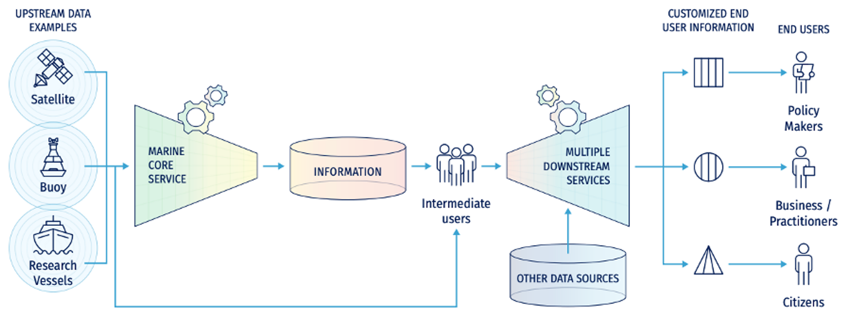
Figure 1The ocean value chain (from Alvarez Fanjul et al., 2022).
Therefore, a core service should have by definition the following characteristics:
-
It feeds from ocean observations, from both satellite and in situ sources.
-
It provides reliable access (production requirements are defined and information provided to users on target delivery time, timeliness and monitoring of dedicated key performance indicators (KPIs)) to both quality-controlled measured and forecasted ocean data.
-
It is user-driven, and specific support to the users is provided.
-
It generates data useful for final and intermediate users, enabling the latter to produce tailored information for final users.
-
The development, evolution and operations are done under well-controlled planning, ensuring availability, timeliness and quality of the resulting products.
The concept of a “core service” was developed in the framework of the Copernicus programme, but the idea of providing reliable and up-to-date information on the state of the environment is universal. There are other global ocean services, such as the Global Ocean Observing System (GOOS), which also provide information on the state of the world's oceans and seas. However, the specific services offered and the way in which they are organised may differ between programmes, so not all of them can be considered core services in the sense developed by Copernicus. Here we define a core service as the provision of open and free data together with dedicated user support with the characteristics described in the next section.
In this chapter, we will focus on the general characteristics of existing global ocean forecasting systems and their collocation in the framework of marine core services and existing international initiatives that support scientific networking and activities for improving and advancing numerical ocean predictions.
The last decade has been characterised by vibrant advancements in numerical ocean modelling and observational networks that have opened new opportunities for improving global ocean monitoring and forecasting. The last review on the status of ocean forecasting systems described in Tonani et al. (2015) outlined that 12 global systems were regularly operating up to 2015 across the world – from France, UK, Norway and Italy to the USA, Canada and Brazil; from Australia to Japan; and from China to India – with an increase of 30 % with respect to 2009, when only 7 were providing forecast products. These actions were and still are supported by an international coordinated effort promoted by the Global Ocean Data Assimilation Experiment (GODAE) over three main steps.
-
Phase 1 – the experiment (Bell et al., 2009). GODAE started in 1998 and developed over 10 years, with the main scopes of the following:
-
applying state-of-the-art ocean models and data assimilation methods for producing short-term forecast and for providing initial and boundary conditions for regional-to-coastal subsystems and
-
providing global ocean analysis to understand the ocean state, to improve predictability, and to support the design and the effectiveness of the global ocean observing system.
-
-
Phase 2 – “science to underpin societal needs” (Bell et al., 2015; Schiller et al., 2015). Following the first step, over the next 10 years, GODAE OceanView consolidated the coordination by launching new activities devoted to developing predictive systems to meet users' needs. Such activities included the following:
-
the consolidation and improvement of global (and regional) systems;
-
the scientific evolution for the next generation of systems;
-
the exploitation of this capacity in other contexts, like ocean reanalysis, weather forecasting, seasonal and decadal prediction, climate change, and coastal impacts;
-
the assessment and the design of the ocean observing network.
-
-
Phase 3 – advancing the science of ocean prediction with OceanPredict. In 2019, GODAE OceanView became OceanPredict, with the main scope to enhance ocean prediction within an overall operational oceanography context (The OceanPredict – Strategy 2021–2030, 2021), by working on five major drivers (https://oceanpredict.org/about/strategy/goals/, last access: 30 April 2025):
-
data assimilation – to improve ocean forecasting and also data assimilation capacity;
-
verification – for monitoring and demonstrating improved accuracy and utility of ocean analysis and forecasting products resulting from OceanPredict contributions, by coordinating regular system intercomparisons and verifications;
-
observing system evaluations – for contributing to projects and assessment to better determine observation impact and feeding back to the observing system community information about opportunities for further improving the impact of observations on forecasting skill;
-
models – collaborating with R&D groups through OceanPredict task teams to improve ocean predictions in shelf seas and coastal environment, for biogeochemical variables and for coupled environmental prediction systems;
-
visualisation – collaborating with ocean product developers and ocean services to improve visualisation and accessibility tools for predictions and observations.
-
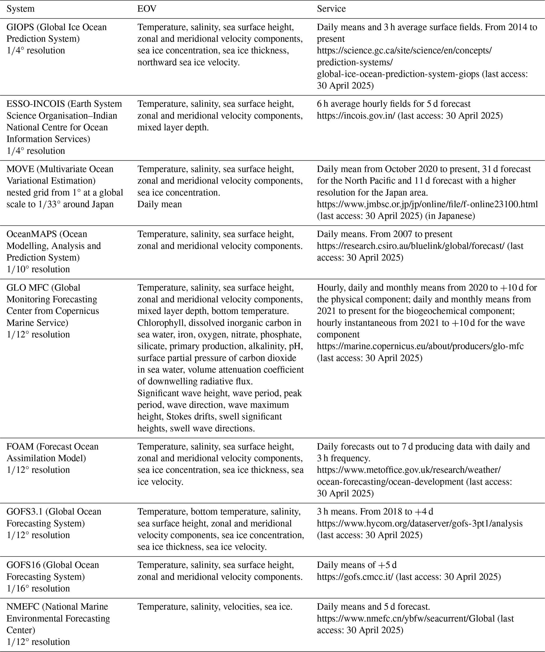
The GODAE/OceanPredict Science Team, which includes more than 30 experts that are leaders in the field of operational oceanography from national, international and intergovernmental organisations, is in charge of maintaining updated information about the current global ocean forecasting capacity of the physical and biogeochemical components, including technical description of the systems and available viewing services. In Alvarez Fanjul et al. (2022), detailed complementary inventories of global ocean systems available worldwide are given. Table 1 summarises services provided by the operational centres (technical characteristics of operational ocean forecasting systems are given in Alvarez Fanjul et al. (2022), showing that state-of-the-art ocean model and data assimilation methods are used to produce standard products including main Essential Ocean Variables (EOVs)).
Table 1Updates on the inventories as given in Alvarez Fanjul et al. (2022) and by OceanPredict (https://oceanpredict.org/science/operational-ocean-forecasting-systems/ocean-products-services/, last access: 30 April 2025), with focus on provided Essential Ocean Variables (EOVs) and summary of offered service.
In the framework of the EU Copernicus programme, the Copernicus Marine Service is organised to provide operational service to external users and to get user feedback to improve an user-driven service. It has been defined with the following specificities:
-
Free access to reliable up-to-date and historic data is key for enhanced knowledge and better understanding of our oceans.
-
Copernicus Marine Service provides data from satellites, in situ sensors and numerical models covering the global ocean and the European regional seas and associated product quality information.
-
Information on past, present and future trends is made available to empower all users who want to drive the Blue Economy, for scientific innovation and to support sustainable ocean initiatives.
-
Anyone can use the data – scientists, policy-makers, entrepreneurs and ordinary citizens, from all over the world.
-
Services and training are tailored and adapted to different levels of expertise and familiarity with ocean data.
-
Users can get help from the Copernicus Marine User support team.
-
Interoperability between different producers is ensured between all the products available in the catalogue and to allow connection between the producers.
-
Standards (including best practices) are defined and applied by the producers for the products (resolution, frequency, variable, time series, forecast length, etc.), the format, the quality information and the timeliness.
User feedback is organised within the core service by collecting and analysing information on access to data, the services offered and user support through surveys and training sessions, as well as through a user uptake programme in the form of projects and thanks to a group of experts (i.e. the Champion User Advisory Group) that analyses and summarises needs.
Access to the Copernicus Marine Product Catalogue is possible through https://marine.copernicus.eu/ (last access: 30 April 2025).
Copernicus Marine Service is organised around Thematic Assembly Centers (TACs) and Monitoring Forecasting Centers (MFCs) (Fig. 2). TACs process data acquired from satellite ground segments and in situ platforms to produce real-time (today) and reprocessed (30-year historic) products. They are organised by thematic hubs including sea ice, wind, sea level, in situ, ocean colour, sea surface temperature, wave and multiple observations. MFCs run ocean numerical models assimilating data provided by TAC data to generate reanalysis (30 years in the past), analysis (today) and 10 d forecasts of the ocean. They are organised in geographical areas, including the global ocean and European seas such as the Arctic Ocean, the Baltic Sea, the Atlantic European North-West Shelf, Iberian–Biscay–Irish seas, the Mediterranean Sea and the Black Sea.
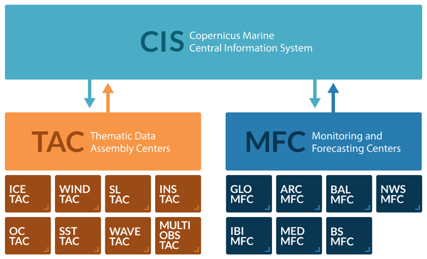
Figure 2Organisation of Copernicus Marine Service including Thematic Assembly Centers (TACs), which provide ocean observations, and Monitoring and Forecasting Centers (MFCs), which provide reanalysis and forecast at a global scale and for the European seas. Exchanges with users happen through the Central Information System (CIS).
Focusing on global ocean forecasting systems, the Copernicus Marine Service, through the GLO MFC, provides marine data (waves, currents, temperature, salinity, sea level and biogeochemistry) for the world's oceans, Atlantic, Indian, Pacific, Arctic and Antarctic, and the European seas. The past, present and future are covered by these data, providing information for 30 years in the past up to 10 d in the future. The portfolio of products (as summarised also in Table 1) includes the following:
-
Near-real-time (NRT) datasets provide physics and waves at ° resolution and biogeochemistry at °, forced by ECMWF IFS atmospheric forecasting product (see https://www.ecmwf.int/en/elibrary/81235-evaluation-ecmwf-forecasts-including-2021-upgrade (last access: 30 April 2025) for a description of the systems and their evolution).
-
Global Ocean Physics Analysis and Forecast, run by Mercator Ocean International, provides analysis and forecast of the 3D ocean regularly every day. The time series is aggregated in time to reach a full 2 years' time in a sliding window to +10 d. The core model is based on NEMO (Nucleus for European Modelling of the Ocean v3.6, coupled to LIM3 sea ice model): it assimilates temperature and salinity profiles as well as sea surface temperature, sea ice concentration and sea level anomaly data, provided by corresponding TACs using the SAM2 data assimilation scheme. Details are given in Le Galloudec et al. (2023) and Lellouche et al. (2023). An example of the sea surface temperature forecast field is given in Fig. 3.
-
Global Ocean Biogeochemistry Analysis and Forecast, run by Mercator Ocean International, provides analysis and forecasts of the 3D global ocean updated weekly. The time series is aggregated similarly to the physical system. The core model is based on NEMO v3.6 online coupled to PISCES for the biogeochemical component: it assimilates satellite ocean colour provided by the OC TAC using the SEEK (Singular Evolutive Extended Kalman) data assimilation scheme. Details are given in Lamouroux et al. (2023) and Lamouroux and Tonani (2023).
-
Global Ocean Waves Analysis and Forecast, run by Météo-France, provides analysis and forecasts of the global ocean sea surface waves. The core model is MFWAM, with spectral resolution of 24 directions and 30 frequencies: it uses optimal interpolation for the assimilation of significant wave height from altimeters. Details are given in Dalphinet et al. (2023) and Aouf (2023).
-
-
Multi-Year (MY) datasets provide physics at ° resolution, biogeochemistry at °, and waves at °, forced by ECMWF ERA5 atmospheric reanalysis (Hersbach et al., 2020).
-
Global Ocean Physics Reanalysis, run by Mercator Ocean International, provides reanalysis of the global ocean covering the altimetry period (from 1993 onward). The core model is based on NEMO v3.1, coupled to LIM2 (Louvain-la-Neuve Sea Ice Model) and implementing the SAM2 (System assimilation Mercator) scheme for the assimilation of reprocessed observations such as satellite sea surface temperature, sea ice concentration, sea level anomaly, in situ temperature and salinity profiles. Details are given in Drevillon et al. (2023a, b).
-
Global Ocean Biogeochemistry Hindcast, run by Mercator Ocean International, provides biogeochemical hindcasts for the global ocean over a period starting in 1993. The core model is based on NEMO v3.6 coupled to PISCES. Details are given in Le Galloudec et al. (2022) and Perruche et al. (2019).
-
Global Ocean Waves Reanalysis, run by Mercator Ocean International, has provided the global wave reanalysis since 1993. The core model is MFWAM, coupled to an optimal interpolation scheme for the assimilation of significant wave height provided by altimeters. Details are given in Law-Chune (2023) and Law-Chune et al. (2023).
-
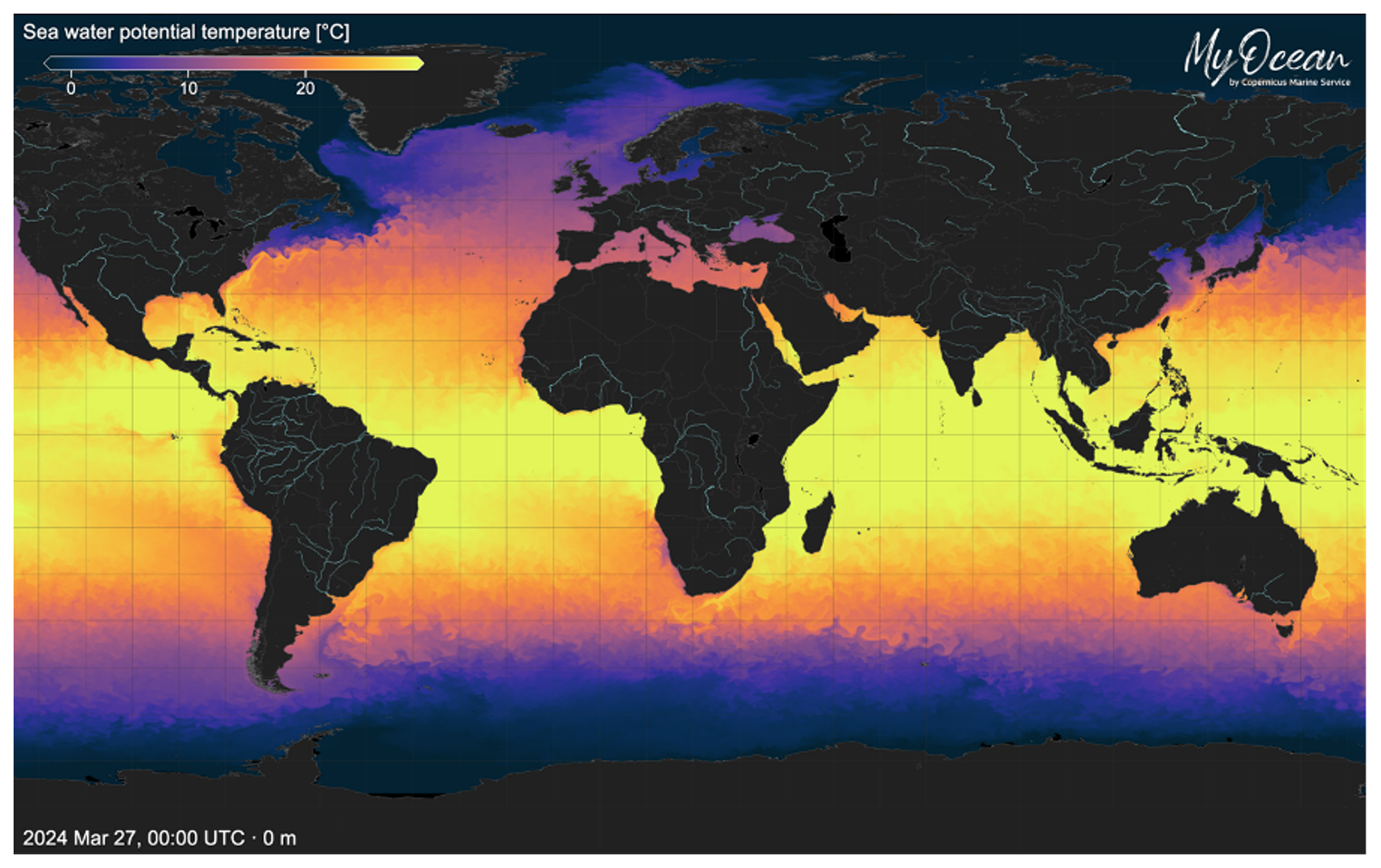
Figure 3Sea surface temperature as predicted by the Global Ocean Physical Analysis and Forecasting System on the 27 March 2024: visualisation provided by the Copernicus Marine Service – MyOcean Pro Viewer.
The list of operational oceanography centres and associated services is evolving rapidly, and the centralisation and updating of this information is one of the important activities for international coordination and is carried out within the framework of OceanPredict (https://oceanpredict.org/science/operational-ocean-forecasting-systems/ocean-products-services/) and the Decade Collaborative Centre for Ocean Prediction, where a dedicated atlas is provided (https://www.unoceanprediction.org/en/atlas/people?lat=16.46769474828897&lng=23.5546875&zoom=2, last access: 30 April 2025).
-
The National Oceanic and Atmospheric Administration (NOAA) is the reference agency in the USA that provides understanding and predictions of changes occurring in climate, weather, ocean and coasts, sharing knowledge and information and conserving and managing coastal and marine ecosystems and resources. The NOAA's National Ocean Service operates with the Center for Operational Oceanographic Products and Services (CO-OPS) for gathering accurate, reliable and timely water-level and current measurements. The NOAA's National Weather Service (https://oceanservice.noaa.gov/, last access: 30 April 2025) provides, through the Environmental Modeling Center, the Global Real-Time Ocean Forecast System products (https://polar.ncep.noaa.gov/global/, last access: 30 April 2025), delivered via FTP. Visualisation of nowcast/forecast products and reference metrics are provided as well through a dedicated web page, available at https://polar.ncep.noaa.gov/global/.
-
From the collaboration between Environment and Climate Change Canada, Fisheries and Oceans Canada, and National Defence departments, the Government of Canada supports the Canadian Operational Network of Coupled Environmental PredicTion Systems (CONCEPTS; https://science.gc.ca/site/science/en/concepts, last access: 30 April 2025) for the monitoring of the met-oceanographic conditions in the country. CONCEPTS provides operational access to real-time forecasts through dedicated web services (i.e. geospatial web services and third-party websites), including bulletins produced with static images. CONCEPTS includes prediction systems like the Global Ice Ocean Prediction System (GIOPS) with delivery of 10 d forecast of daily ocean and sea ice analysis, together with regional systems (e.g. the Regional Ice Ocean Prediction System (RIOPS) and the Regional Deterministic Prediction System Coupled over the Gulf of St. Lawrence (RDPS-CGSL)) and a dedicated one for the Great Lakes (i.e. the Water Cycle Prediction System Coupled over the Great Lakes (WCPS-CGL), https://science.gc.ca/site/science/en/concepts/prediction-systems, last access: 30 April 2025).
-
The European Centre for Medium-Range Weather Forecasts (ECMWF) develops and maintains an operational system called OCEAN5 (https://www.ecmwf.int/en/research/climate-reanalysis/ocean-reanalysis, last access: 30 April 2025), a global eddy-permitting ocean-sea ice ensemble with five members from 1979 to present. It includes a behind-real-time (BRT) component to produce ocean reanalysis from 1979 to present (ORAS5; https://cds.climate.copernicus.eu/cdsapp#!/dataset/reanalysis-oras5?tab=overview, last access: 30 April 2025) and a real-time (RT) component, initialised from the last BRT analysis to compute an analysis up to real time every day using a variable assimilation window. Data are accessible through the Copernicus Climate Data Store and are used for performing past reconstruction of the ocean climate state at a global scale.
-
The Australian Government Bureau of Meteorology is Australia's national weather, climate and water agency (http://www.bom.gov.au/?ref=hdr, last access: 30 April 2025). It provides marine and ocean products such as wind maps, tide predictions, sea temperature and currents, wave maps, and seasonal ocean temperature. The service is for citizens and society, so the communication is done through VHF, radio and radiofax, internet, and satellite.
-
The Japan Meteorological Agency (JMA; https://www.jma.go.jp/jma/indexe.html, last access: 30 April 2025) is the reference Japanese agency for monitoring weather, earthquakes and volcano activities. The ocean component of the JMA carries out oceanographic and marine meteorological observations in the western North Pacific and seas adjacent to Japan. Additionally, it operates with a set of operational ocean data assimilation and prediction systems named MOVE for preventing coastal disasters; supporting fishery, marine transportation and marine industry; and providing the oceanic initial conditions for the coupled atmosphere–ocean forecasting systems (Hirose et al., 2019; Fujii et al., 2023; Yamanaka et al., 2023).
-
The China Meteorological Administration (CMA; https://www.cma.gov.cn/en/, last access: 30 April 2025) is an operator, service-provider and regulator in weather forecasting and warning, climate prediction and public meteorological services. The National Meteorological Centre (NMC) undertakes the responsibility of issuing forecasts and warnings for 13 different types of hazardous weather conditions within the next 24 h. These include typhoons, heavy rain, severe convective weather, blizzards, cold waves, gales at sea, sandstorms, low temperatures, high temperatures, frosts, ice storms, heavy fog, and haze. The Beijing Climate Centre operates its own global ocean system for the monitoring of the ocean climate events like El Niño in the central and eastern equatorial Pacific (https://www.cma.gov.cn/en/forecast/news/202402/t20240229_6093860.html, last access: 30 April 2025).
-
The National Marine Environmental Forecasting Center (NMEFC; http://www.nmefc.cn/hailiu/quanqiu.aspx, last access: 30 April 2025) is the national operation and research centre for marine environmental forecasting and marine hazard warning and provides advisory information for public policy, decision-making, and socio-economic and sustainable development, which is a public institution directly under the Ministry of Natural Resources of China.
-
Mercator Ocean International (MOi; https://www.mercator-ocean.eu/, last access: 30 April 2025) is a non-profit organisation, in the process of transforming into an intergovernmental organisation, providing ocean-science-based services of general interest focused on the conservation and the sustainable use of the oceans, seas and marine resources. After running the European MyOcean projects since 2009, Mercator Ocean was officially appointed by the European Commission on 11 November 2014 to implement the European ocean-monitoring service, the Copernicus Marine Service, as part of the European Earth observation programme, Copernicus.
-
The Met Office (https://www.metoffice.gov.uk/, last access: 30 April 2025) is the UK's national weather and climate service and produces operational global and regional ocean forecasts on a daily basis using the FOAM system as well as waves, storm surge and ecosystem predictions. The research effort is reinforced by a close collaboration with academic groups, including those in the National Partnership for Ocean Prediction (NPOP).
-
The CMCC (https://www.cmcc.it/, last access: 30 April 2025) Foundation (Euro-Mediterranean Center on Climate Change) is an international, independent, multi-disciplinary research centre that studies the interaction between climate change and society. They produce advanced climate research developing cross-cutting and multidisciplinary analyses and data that combine first-class climate modelling with climate change impact modelling and environmental economics.
-
ESSO-INCOIS (https://incois.gov.in/portal/aboutus, last access: 30 April 2025) was established as an autonomous body in 1999 under the Ministry of Earth Sciences (MoES) and is a unit of the Earth System Science Organisation (ESSO). ESSO-INCOIS is mandated to provide the best possible ocean information and advisory services to society, industry, government agencies and the scientific community through sustained ocean observations and constant improvements through systematic and focussed research.
The development of operational ocean analysis and forecasting systems began in the late 1990s for institutional and expert users. The first systems produced analyses and forecasts of the physical ocean at intermediate resolutions (between 1° and °) and frequencies that were daily at best. The output from these systems was made available directly on supercomputers or on archive centres or ftp servers. The progress made in production systems was accompanied by progress in dissemination systems, visualisation tools, data processing and the support provided to users in order to create what are currently called core services. The horizontal resolution of global models now reaches a few kilometres, and the temporal resolution of forecasts updated daily can be hourly, with assimilated data and model forcings also having progressed in line with the targeted resolutions. Data are now distributed on cloud servers in optimised formats, enabling large volumes of data to be viewed and handled efficiently. Standardisation of the associated documentation and monitoring of operational production and user support mean that these operational products can be used more easily. The number of users of operational oceanography products has risen sharply, with some core services currently able to serve several tens of thousands of users. Digital Twin Ocean's developments will make it possible to integrate new technologies and, in the near future, will represent an important evolution in the core service for operational oceanography.
No data sets were used in this article.
YD led the paper and wrote and structured the paper. All co-authors provided comments and corrections for an initial version of the paper.
At least one of the (co-)authors is a member of the editorial board of State of the Planet. The peer-review process was guided by an independent editor, and the authors also have no other competing interests to declare.
Publisher's note: Copernicus Publications remains neutral with regard to jurisdictional claims made in the text, published maps, institutional affiliations, or any other geographical representation in this paper. While Copernicus Publications makes every effort to include appropriate place names, the final responsibility lies with the authors.
The authors acknowledge the European Commission, Copernicus Marine Service, OceanPredict and the Decade Collaborative Centre for Ocean Prediction in the framework of the UN Decade of Ocean Science for Sustainable Development.
This paper was edited by Kirsten Wilmer-Becker and reviewed by two anonymous referees.
Alvarez Fanjul, E., Ciliberti, S., Bahurel, P.: Implementing Operational Ocean Monitoring and Forecasting Systems, IOC-UNESCO, GOOS-275, https://doi.org/10.48670/ETOOFS, 2022.
Aouf, L.: Quality Information Document for Global Ocean Wave Analysis and Forecasting Product, Copernicus Marine Service report, https://catalogue.marine.copernicus.eu/documents/QUID/CMEMS-GLO-QUID-001-027.pdf (last access: 20 March 2024), 2023.
Bell, M., Schiller, A., Le Traon, P.-Y., Smith, N. R., Dombrowsky, E., and Wilmer-Becker, K.: An introduction to GODAE OceanView, J. Oper. Oceanogr., 8, s2–s11, https://doi.org/10.1080/1755876X.2015.1022041, 2015.
Bell, M. J., Lefebvre, M., Le Traon, P.-Y., Smith, N., and Wilmer-Becker, K.: GODAE The Global Ocean Data Assimilation Experiment, Oceanography, 22, 14–21, https://www.jstor.org/stable/24860986 (last access: 11 March 2024), 2009.
Dalphinet, A., Aouf, L., Law-Chune, S., and Tressol, M.: Product User Manual for Global Ocean Wave Analysis and Forecasting Product, Copernicus Marine Service, https://catalogue.marine.copernicus.eu/documents/PUM/CMEMS-GLO-PUM-001-027.pdf (last access: 20 March 2024), 2023.
Drevillon, M., Fernandez, E., and Lellouche, J. M.: Product User Manual for the Global Ocean Physical Multi Year product, Copernicus Marine Service, https://catalogue.marine.copernicus.eu/documents/PUM/CMEMS-GLO-PUM-001-030.pdf (last access: 20 March 2024), 2023a.
Drevillon, M., Lellouche, J. M., Regnier, C., Garric, G., Bricaud, C., Hernandez, O., and Bourdalle'-Badie, R.: Quality Information Document for Global Ocean Physical Multi Year product, Copernicus Marine Service, https://catalogue.marine.copernicus.eu/documents/QUID/CMEMS-GLO-QUID-001-030.pdf (last access: 20 March 2024), 2023b.
Fujii, Y., Yoshida, T., Sugimoto, H., Ishikawa, I., and Urakawa, S.: Evaluation of a global ocean reanalysis generated by a global ocean data assimilation system based on a four-dimensional variational (4DVAR) method, Front. Clim., 4, 1019673, https://doi.org/10.3389/fclim.2022.1019673, 2023.
Hersbach, H., Bell, B., Berrisford, P., Hirahara, S., Horányi, A., Muñoz-Sabater, J., Nicolas, J., Peubey, C., Radu, R., Schepers, D., Simmons, A., Soci, C., Abdalla, S., Abellan, X., Balsamo, G., Bechtold, P., Biavati, G., Bidlot, J., Bonavita, M., De Chiara, G., Dahlgren, P., Dee, D., Diamantakis, M., Dragani, R., Flemming, J., Forbes, R., Fuentes, M., Geer, A., Haimberger, L., Healy, S., Hogan, R. J., Hólm, E., Janisková, M., Keeley, S., Laloyaux, P., Lopez, P., Lupu, C., Radnoti, G., de Rosnay, P., Rozum, I., Vamborg, F., Villaume, S., and Thépaut, J. N.: The ERA5 global reanalysis, Q. J. Roy. Meteor. Soc., 146, 1999–2049, https://doi.org/10.1002/qj.3803, 2020.
Hirose, N., Usui, N., Sakamoto, K., Tsujino, H., Yamanaka, G., Nakano, H., Urakawa, S., Toyoda, T., Fujii, Y., and Kohno, H.: Development of a new operational system for monitoring and forecasting coastal and open ocean states around Japan, Ocean Dynam., 69, 1333–1357, https://doi.org/10.1007/s10236-019-01306-x, 2019.
Lamouroux, J. and Tonani, M.: Product User Manual for Global Ocean Biogeochemical Analysis and Forecasting Product, Copernicus Marine Service, https://catalogue.marine.copernicus.eu/documents/PUM/CMEMS-GLO-PUM-001-028.pdf (last access: 20 March 2024), 2023.
Lamouroux, J., Perruche, C., Mignot, A., Paul, J., and Szczypta, C.: Quality Information Document for Global Ocean Biogeochemical Analysis and Forecasting Product, Copernicus Marine Service, https://catalogue.marine.copernicus.eu/documents/QUID/CMEMS-GLO-QUID-001-028.pdf (last access: 20 March 2024), 2023.
Law-Chune, S.: Product User Manual for the Global Ocean Wave Multi Year product, Copernicus Marine Service, https://catalogue.marine.copernicus.eu/documents/PUM/CMEMS-GLO-PUM-001-032.pdf (last access: 20 March 2024), 2023.
Law-Chune, S., Aouf, L., Levier, B., and Dalphinet, A.: Quality Information Document for the Global Ocean Wave Multi Year product, Copernicus Marine Service, https://catalogue.marine.copernicus.eu/documents/QUID/CMEMS-GLO-QUID-001-032.pdf (last access: 20 March 2024), 2023.
Le Galloudec, O., Perruche, C., Derval, C., Tressol, M., and Dussurget, R.: Product User Manual for the Global Ocean Biogeochemistry Multi Year product, Copernicus Marine Service, https://catalogue.marine.copernicus.eu/documents/PUM/CMEMS-GLO-PUM-001-029.pdf (last access: 20 March 2024), 2022.
Le Galloudec, O., Law Chine, S., Nouel, L., Fernandez, E., Derval, C., Tressol, M., Dussurget, R., Biardeau, A., and Tonani, M.: Product User Manual for Global Ocean Physical Analysis and Forecasting Product, Copernicus Marine Service, https://catalogue.marine.copernicus.eu/documents/PUM/CMEMS-GLO-PUM-001-024.pdf (last access: 20 March 2024), 2023.
Lellouche, J.-M., Le Galloudec, O., Regnier, C., Van Gennip, S., Law Chune, S., Levier, B., Greiner, E., Drevillon, M., and Szczypta, C.: Quality Information Document for Global Ocean Physical Analysis and Forecasting Product, Copernicus Marine Service, https://catalogue.marine.copernicus.eu/documents/QUID/CMEMS-GLO-QUID-001-024.pdf (last access: 20 March 2024), 2023.
Perruche, C., Szczypta, C., Paul, J., and Drevillon, M.: Quality Information Document for the Global Ocean Biogeochemistry Multi Year product, Copernicus Marine Service, https://catalogue.marine.copernicus.eu/documents/QUID/CMEMS-GLO-QUID-001-029.pdf (last access: 20 March 2024), 2019.
Schiller, A., Bell, M., Brassington, G., Brasseur, P., Barcieli, R., De Mey, P., Dombrowsky, E., Gehlen, M., Hernandez, F., Kourafalou, V., Larnico, G., Le Traon, P.-Y., Martin, M., Oke, P., Smith, G. C., Smith, N., Tolman, H., and Wilmer-Becker, K.: Synthesis of new scientific challenges for GODAE OceanView, J. Oper. Oceanogr., 8, s259–s271, https://doi.org/10.1080/1755876X.2015.1049901, 2015.
The OceanPredict – Strategy 2021–2030: https://oceanpredict.org/docs/Documents/General%20documents/Strategic_Plan_OceanPredict_20210723-final.pdf (last access: 17 March 2024), 2021.
Tonani, M., Balmaseda, M., Bertino, L., Blockley, E., Brassington, G., Davidson, F., Drillet, Y., Hogan, P., Kuragano, T., Lee, T., Mehra, A., Paranathara, F., Tanajura, C. A. S., and Wang, H.: Status and future of global and regional ocean prediction systems, J. Oper. Oceanogr., 8, s201–s220, https://doi.org/10.1080/1755876X.2015.1049892, 2015.
Yamanaka, G., Fujii, Y., Usui, N., and Hirose, N.: JMA Operational Ocean Prediction – MOVE/MRI.COM, Copernicus Marine Service, https://oceanpredict.org/docs/Documents/OPST/Meetings/OPST-8-Nov-2023/Presentations/6.15-OPOS-JMA-MOVE-MRI-COM-GoroYamanaka.pdf (last access: 20 March 2024), 2023.
- Abstract
- Introduction
- Global ocean forecasting systems: where we are today
- The Copernicus Marine Service as reference core service and its offer for the global ocean
- Other worldwide ocean services
- Conclusion
- Data availability
- Author contributions
- Competing interests
- Disclaimer
- Acknowledgements
- Review statement
- References