the Creative Commons Attribution 4.0 License.
the Creative Commons Attribution 4.0 License.
 | 02 Jun 2025 | OPSR | Chapter 6.2
A description of validation processes and techniques for ocean forecasting
Marcos Garcia Sotillo
Marie Drevillon
Fabrice Hernandez
The architecture of operational forecasting systems requires clear identification of best practices for assessing the quality of ocean products: it plays a key role not only for the qualification of prediction skill but also for the advancing of the scientific understanding of the ocean dynamics from global to coastal scales. The authors discuss the role of the observing network in performing validation of ocean model outputs, identifying current gaps (i.e. different capacity to assess physical essential ocean variables versus biogeochemical ones) but also emphasizing the need for new metrics (tailored for end users' comprehension and usage). An analysis on the level of maturity of validation processes from global to regional systems is provided. A rich variety of approaches exist, and the more we move towards the coast, the higher the complexity in calculating such metrics is, due to increased resolution, but we are also somehow limited by the lack of coastal observatories worldwide. An example is provided of how the Copernicus Marine Service currently organizes product quality information from producers (with dedicated scientific documentation, properly planned and designed) to end users (with publication of targeted estimated accuracy numbers for its whole product catalogue).
- Article
(681 KB) - Full-text XML
- BibTeX
- EndNote


Product quality assessment is a key issue for operational ocean forecasting systems (OOFSs). There is a long tradition in scientific research related to model validation, and, through coordinated community initiatives, in recent times there has been important progress in this field, related to operational oceanographic services (Hernandez et al., 2015, 2018).
Strong efforts to define operational oceanography's best practices have started, among others the Ocean Best Practices (Pearlman, et al., 2019 and https://www.oceanbestpractices.org/, last access: 30 April 2025) and the Guide on Implementing Operational Ocean Monitoring and Forecasting Systems delivered by ETOOFS (Expert Team on Operational Ocean Forecasting Systems, https://www.mercator-ocean.eu/en/guide-etoofs/, last access: 30 April 2025; Alvarez Fanjul et al., 2022). In the latest ETOOFS guide, several sections are dedicated to model validation, i.e. Sect. 4.5 on validation and verification, and sub-sections on validation strategies for ocean physical models (Sect. 5.7), sea ice models (Sect. 6.2.6), storm surge (Sect. 7.2.6), wave models (Sect. 8.7) and biogeochemistry models (Sect. 9.2.6), as well as a specific section (Sect. 12.9) on quality assessment for intermediate and end users.
The main goal of this paper is to describe the status of the validation of ocean forecasting products. In Sect. 2, the crucial role that observational data sources play in the validation of ocean models is discussed, as well as how identified gaps in the observations determine model validation processes, limiting them for some Essential Ocean Variables on some temporal scales and in specific zones (i.e. on shelf and in the coastal zone). An analysis on the level of maturity of validation processes applied by OOFSs is provided in Sect. 4. Operational processes implemented in the Copernicus Marine Service for product quality across global and (European) regional model systems are analysed in Sect. 4.1, whereas Sect. 4.2 provides a view of model validation approaches applied by (non-European) regional and coastal operational services around the world. Finally, conclusions are delivered in Sect. 5.
The lack of observations is the primary, and obvious, difficulty of validating an OOFS at a specific site. In that sense, it is very difficult to overcome observational gaps, and, if they exist, OOFS validation processes are seriously hindered by them.
Validation is a global necessity and challenge. Capet et al. (2020) provide a complete overview and mapping of the current European capability in terms of OOFSs, including contributions from 49 organizations around Europe about 104 operational model systems, mostly simulating hydrodynamics, biogeochemistry and sea waves. This contribution shows how, and to what extent, different observational data sources are used for model skill assessment. As shown in Fig. 1, most of the model validation systems mainly use fixed platforms, satellite remote sensing and coastal tide gauges.
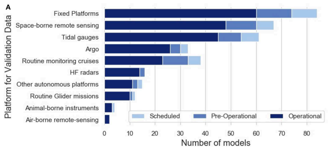
Figure 1From Capet et al. (2020). Observing platforms providing data used for model skill assessment and validation purposes and number of models (from the EuroGOOS survey that uses them).
It is important to note that the aggregated results of the study do not provide differences between basin/regional systems and the more coastal ones. Indeed, in this contribution most of the near-real-time (NRT) systems of the Copernicus Marine Service regional monitoring and forecasting centres are included, causing some observational data sources that are not so coastally oriented such as the Argo to be used by a high number of European OOFSs. The same may happen with the use of spaceborne remote sensing products, which are more limited in their use for validation OOFSs as we move to more limited small coastal model domains.
Use of satellite products for OOFS validation is common in the case of global, basin and regional systems but limited in the case of coastal ones. If used, it is done mainly by those coastal systems that present a bigger spatial geographical coverage (going beyond the shelf break). Furthermore, new incoming observational technologies (i.e. the new Sentinel missions, swath altimetry, HF radars, BGC-Argo, etc.) and opportunities to use new coastal observing systems (links with member state networks and/or specific research and development projects) will enhance model validation capacities. New validation tools may also be developed for coordinated Observing System Experiments (OSEs) and Observing System Simulation Experiments (OSSEs), related to the optimization of these observation networks. Taking advantage of the framework of these OSSEs, AI-emulated variables will be developed, which will increase validation capacities. Increased awareness of the need for enhancing observing networks, bringing new initiatives and efforts to better integrate existing ocean observing systems with the OOFS validation processes, is needed.
In terms of ocean model validation, there is a different level of application depending on which Essential Ocean Variable (EOV) is targeted. The Copernicus Marine Service, a comprehensive multi-product service dealing with more than 150 operational products that involves more than 60 EOVs for the blue, green and white ocean, can illustrate such differences across EOVs. The document that provides the terms of reference for all the product quality (PQ) assessment done within the service and the long-term strategy for the PQ enhancement (Copernicus Marine PQ Strategic Plan; Sotillo et al., 2021) includes the following points about the different level of maturity in terms of model validation across EOVs in its analysis of strengths and weaknesses.
-
In terms of the physic blue world versus the green biogeochemistry component, the assessment of physical parameters is more developed than the one for biogeochemistry parameters; the Copernicus Marine Service identifies the need of special efforts for biogeochemical model product validations. The lack of biogeochemistry observations conditions not only the biogeochemical model validation but even the modelling itself. Due to the lack of in situ data, some phenomena such as primary production and bloom of phytoplankton are assessed using chlorophyll Ocean Colour satellite data most of the time, which have some limitations related to coverage and resolution, especially for the coastal zones. Furthermore, it is necessary to also assess the factors that cause these blooms (i.e. transport of nutrients) in biogeochemical models. Carbon, oxygen and ocean acidification are parameters of interest at both regional and global scales that need better validation. BGC-Argo floats can enhance the monitoring but mostly off shelves and far from coastal areas. Finally it is mentioned that in the biogeochemical model validation, it is important to evaluate the errors in the physical system together, particularly vertical transport and mixing, which strongly impact the coupled biogeochemical models. Thus, monitoring of errors on key parameters of the physical forcing should help to characterize the causes of errors of biogeochemical products.
-
Sea ice concentration, due mainly to observation by satellites, is assessed and brings validation to sea ice extent, sea ice drift, sea ice thickness and sea ice edge. New validation metrics (some related to end-user needs) should be developed for sea ice temperature and iceberg concentration maps, and specific assessments of multi-year sea ice parameters need to be specifically addressed on interannual timescales.
-
Sea surface temperature is the most used EOV, being the most monitored parameter that is usually assessed with (in situ and remotely sensed) multi-product approaches that consider regional specificities (for high-frequency products, particular attention should be paid to diurnal cycle and tidal mixing effects). Generally, validation on surface layers is privileged with respect to the rest of the layers across the water column, a clear decreasing gradient existing towards deeper levels. The availability of in situ observations has greatly improved since the 2000s with the Argo programme. At depth, T and S data are the most used observations in product quality assessment. However, at synoptic scales, water mass distribution stays partially sampled in the upper ocean. There are significant regional differences, the coastal areas not always being the privileged ones (indeed, the autonomous Argo measure network changed the usual fact of coastal and on-shelf areas being the more sampled traditionally).
-
In the case of salinity, in situ measurements from fixed moorings, Argo drifters, or offshore coastal profiles with CTD or XBT instruments, as well as surface transects with thermo-salinometers, are the most common data sources used for OOFS model validation. Averaged maps of sea surface salinity derived from remotely sensed satellite data (such as the SMOS ones) can be used to validate models, especially far from coastal areas.
-
The approach to regionally validate sea level model solutions is based on comparison to satellite altimetry, at the scales of interest, from open-ocean to coastal dynamical responses. Enhancement of sea level validation in coastal and on-shelf areas is needed, and preparation for the use of the new wide-swath altimetry products should be done in the coming years. On the other hand, comparisons of coastal OOFS model products with in situ sea level measurements from tide gauge are quite common. External metrics linked to storm surge services (including total sea levels, tidal solution and residuals) are considered. For many coastal forecast systems, especially for those with more limited spatial coverages, the comparison of the simulated sea level with local observation from a tide gauge, usually installed in ports and the unique NRT ocean measurement available, is the only feasible direct model–observation comparison.
-
Ocean currents and associated transport, especially near the surface, are parameters with a strong impact in many applications. Their assessment is usually done using independent observations (as most of today's systems do not assimilate this kind of observation). For this purpose, in situ observations from current meters and acoustic Doppler current profilers (ADCPs), installed at mooring buoy stations, as well as remotely sensed data from coastal HF radar systems, are used to validate simulated currents at specific locations. The proliferation of surface velocity products derived from drifters' observations as pseudo-Eulerian estimated maps at global and regional scales also contributes to the validation of ocean models. Finally, satellite altimetry can also be used to assess geostrophic/non-geostrophic properties of the ocean, and some derived estimation of currents from satellite synthetic-aperture radar (SAR), or from sea surface temperature (SST) or Ocean Colour images, can also be used in specific areas.
A discussion on the status of operational validation across different existing OOFSs is provided here. There are significant differences in the status of the operational validation procedures applied by global, basin and regional systems and the ones applied by the coastal services.
To illustrate how operational validation is being performed by basin and regional OOFSs, Sect. 4.1 provides the approach followed by the Copernicus Marine Service as an example. In this service, outcomes from the validation of several global and regional models contribute to the generation of a variety of product quality information across products that is delivered to users.
On the other hand, in the case of more localized national/coastal OOFSs, there is a variety of model validation approaches. Section 4.2 reviews them, providing the European space information from the EuroGOOS coastal model capability mapping, and different examples are given from systems located all over the world (including North and South America, Africa, and Asia).
4.1 Validation of global, basin and regional model systems: the Copernicus Marine example
The Copernicus Marine Service (Le Traon et al., 2019) delivers consistent, reliable and state-of-the-art information derived both from space or in situ observations and from models – including forecasts, analyses and reanalyses – on the physical and biogeochemical state over the global ocean and the European regional seas. As stated in the previous section, the extensive multi-product portfolio offered, comprising more than 150 operational products and involving more than 60 EOVs for the blue, green and white ocean, established the Copernicus Marine Service as a benchmark in operational oceanography. The service relies on a network of producers, interconnecting several European OOFSs at global and regional scales: 7 Copernicus Monitoring and Forecasting Centers (MFCs) run ocean numerical models, assimilating data, in order to generate long-term reanalysis products, as well as conducting near-real-time analysis and 10 d forecasts of the ocean.
Model validation in the Copernicus Marine Service is closely linked to the operational production performed at the OOFS level. This connection spans all service phases, from design to the operational delivery of products, including associated communication and training activities. Furthermore, a scientifically sound and effectively communicated product quality assessment stands as one of the key cross-cutting functions of the Copernicus Marine Service, Further details of its achievements during the first phase of the service can be found in Sotillo et al. (2022).
Individual OOFSs, producers of the regional components of the Copernicus Marine Service, verify the scientific quality of their model products (i.e. NRT forecast/analysis and MY reanalysis) daily, using quantitative validation metrics, described in standard protocols and plans, and using any available observational data sources extensively, as referred to in previous sections. Regular updates of a subset of the validation metrics assessed by the own producers, including Class 2 validation of model products at mooring sites and Class 4 regional validation metrics, are made available to end users through a dedicated website (the Copernicus Marine Product Quality Dashboard, http://pqd.mercator-ocean.fr, last access: 30 April 2025).
Furthermore, the Copernicus Marine Service is responsible for informing end users about relevant PQ information in a transparent way. For this purpose, reference scientific PQ documentation is issued for each delivered product. These documents, stating the expected quality of a product by means of validation metrics computed along the qualification phase of the new model system, are updated for every quality change associated with any new operational release.
The Copernicus Marine Service model production needs to be carefully monitored at each step, and then, the quality of any upstream data used in the model runs can be properly assessed (even if such upstream data are quality-controlled by the data providers). Indeed, regular exchanges are organized between observations and model producers within the service to discuss data assimilation and validation issues. Scientific quality is one of the key performance indicators for the OOFS, and producers report quarterly to the service on quality monitoring activities. Any change affecting model solutions required to be justified from a product quality perspective.
The consistency in the choice of model validation metrics, and in the way they are presented, can be important because it makes it easier for users to understand the product quality information provided across products and to browse in the service portfolio which products are fit for purpose. However, given the wide range of Copernicus Marine products and production methods, it is not always scientifically meaningful to provide the same type of information across products and for all involved systems. The product quality cross-cutting strategy (Sotillo et al., 2021) thus aims to strike a balance between the level of homogeneity of the information delivered and its relevance. Indeed, the Copernicus Marine Service is a first achievement towards the interconnection of operational oceanography services at basin scale, and digital ocean platforms based on cloud technology will enable new validation capacities, facilitating the set-up of dynamic uncertainty for most of their products. The frequency of the updates will also increase to better serve coastal OOFS, where short-term forecast and quality information should be delivered on a daily (preferred) or weekly basis.
4.2 Validation of coastal OOFSs: a world of variety
There is not a common operational validation approach in coastal OOFSs, and the degree of operationality for the model validation is highly dependent on the type of forecasting system set-up (i.e. system with data assimilation scheme activated, generating analysis, or on the other hand, OOFSs based on a free forecast model system); the extension of the area of interest (being different for very limited coastal systems or going into a larger regional extent); the service purpose (system targeted on a primary end user with specific interests or needs, or if the OOFS delivers a general multi-parameter/purpose service); and finally in the availability, and degree of operational access, of local in situ observational data sources.
Most of the OOFSs have some system validation. Even those models used for research purposes or in the process of maturing their operationality (pre-operational state) have some kind of model validation, typically the early stages of the model set-up configuration, often running in hindcast mode for specific time periods to take advantage of existing observational data campaigns. In pre-operational systems, or in the early stages of OOFS services, an operational validation system is not so common, while model providers are working on the configuration of operational processes for an automatic PQ model assessment and, meanwhile, maintaining some offline model validation (using available observations or focused on specific targeted periods when outstanding events occurred or when observational campaigns are available).
It is worth noting that Capet et al. (2020) conclude that only 20 % of models provide a dynamic uncertainty together with the forecasted EOVs, which would be required for a real-time provision of confidence levels associated with the forecasts (e.g. as is usual for instance in weather forecasts). Usually, model providers perform operational and offline validations, focusing mostly on the best-estimate solution and not so on the forecast skill assessment; scientific statistical metrics are computed using available in situ observational data sources from their own networks or external observational data providers (using observational products from core services such as Copernicus; other national, regional or local public providers; or the industry, if available); in coastal high-resolution systems, with quite limited geographical domains, the use of satellite data is not so common for model validation due to both the lack of remotely sensed product coverage and the higher uncertainty of remotely sensed coastal data. This is the case of many OOFSs all over the world. For instance, the South African ocean forecast system (SOMISANA – Sustainable Ocean Modelling Initiative: a South African approach; https://somisana.ac.za/, last access: 30 April 2025) delivers downscaling of global model products for specific coastal applications in key coastal areas. In these cases, scientific model validation is mostly done offline by model producers, comparing their best estimated hindcast solutions with the existing historic observations. Given the coastal nature of the models, the validation process is focussed mainly on coastal moorings with the model domains. These include coastal temperature recorders, bottom mounted thermistor strings, wire-walker moorings and ADCP moorings from previously published datasets (e.g. Lucas et al., 2014; Pitcher et al., 2014; Goschen et al., 2015) as well as unpublished datasets from local institutes. Currently, there is no direct transfer of information about the product quality from the service to the OOFS users, neither computation of forecast skill assessment nor end-user-oriented metrics. However, some interesting initiatives, mostly linked with the engaging of stakeholder and product disseminations through end-user services platforms, are ongoing, and in the SOMISANA OOFS roadmap the implementation of an operational validation protocol is included, including forecast assessment.
The most common situation is that model validation is performed by the OOFS providers themselves. However, in some cases (usually targeted services), there may be options for some external validation, performed not by the provider itself but directly by the targeted end user(s). This is the case of the DREAMS service (Hirose et al., 2013, 2021) on the west Japanese coast, where model solutions are validated directly by the end users of the service: in this case, fisheries, through a programme with fishing boats as the ship of opportunity (Ito et al., 2021). The DREAMS model provider states the following:
The fishers watch the coastal ocean carefully to achieve better catches. They are inevitably the serious users who can claim the quality of prediction.
In the case of the Brazilian REMO service (Lima et al., 2013; Franz et al., 2021), the validation is done in-house only for targeted end users, either by the Navy or by the PETROBRAS oil company teams. On the PETROBRAS side, they have several current meter sites where they compare in situ measurements, not only with the REMO forecast but also with all the other available ocean forecasting systems that deliver forecasts on that given day. On the Navy side, they do several validations that include the thermohaline structure and Taylor diagrams for a few properties, as well as the transport for the Brazil Current and the tidal analysis of both level and currents where they have data available. Furthermore, there can be very high resolution coastal OOFSs that can be implemented for specific purposes, running only along designated periods, to provide model data as input, for instance, during the design and construction phases of large infrastructures. In such cases, the implementation of the specific model solution can go together with some monitoring activity in the targeted area, allowing some model validation throughout the construction phase and after operations commence. In this type of service, modelling and validation are typically done in-house, with products and results rarely being publicly disseminated, not contributing to the literature.
There are coastal systems that have big domains (going into regional) and that may include data assimilation schemes or pure forecast local coastal systems (run by providers of regional/basin systems in which the local systems are nested) that tend to have operational validation systems (taking advantage of the extensive use of the observational data sources done for assimilation purposes). There are examples of OOFSs supported by state agencies, such as the Canadian Government CONCEPTS (Canadian Operational Network for Coupled Environmental Prediction Systems) that develops and operates a hierarchy of OOFSs. These include the whole downscaling approach: going in this Canadian case from the Global Ice Ocean Prediction System (GIOPS; Smith et al., 2016) used to initialize coupled deterministic medium range predictions (Smith et al., 2018), as well as ensemble predictions (Peterson et al., 2022). The global system provides boundary conditions to the Regional Ice-Ocean Prediction System (RIOPS; Smith et al., 2021), which in turn provides boundary conditions and nudging fields for the Coastal Ice Ocean Prediction System (CIOPS; Paquin et al., 2024). Recently, six port-scale prediction systems have also been put in place. Paquin et al. (2019) presented the prototype of the mentioned port models, whereas Nudds et al. (2020) presented the initial intercomparison projects that took place to compare the NEMO model implementation described in Paquin et al. (2019) with an unstructured model implementation using the Finite Volume Community Ocean Model (FVCOM). CONCEPTS also develops and operates deterministic and ensemble wave and storm surge prediction systems. Proposed changes to these systems must follow a set of formalized verification standards. Evaluation of forecast skill as a function of lead time is also done. Monitoring systems are also in place to ensure the quality of real-time analyses. Forecasts are evaluated in near-real time as part of the OceanPredict Class 4 intercomparison activity (Ryan et al., 2015), and evaluations are predominately made against available observations, but also include comparison to analyses for the longer-range coupled forecasts. These include assimilated satellite (sea level anomaly, sea surface temperature, sea ice concentration) and in situ observations (Argo, buoys, moorings, gliders, field campaigns, etc.). Additional independent evaluations are made against tide gauges, ADCPs, HF radars, drifters and ice beacons (Chikhar et al., 2019) and estimates of sea ice and snow thickness. Evaluations are also done of transports across reference sections and of surface fluxes (both against observations as well as in terms of budget; e.g. Roy et al., 2015; Dupont et al., 2015). Finally, user-relevant verification is done in terms of sea ice (e.g. probability of ice, ice formation and melt dates) and ocean (e.g. eddy identification and properties) features (Smith and Fortin, 2022). An ongoing effort is underway to quantify unconstrained variability in the systems and to provide uncertainty estimates to users.
There are also coastal OOFSs delivered by national agencies or organisms that run their own observational networks. This is the case in Spain of ocean model systems from different state and regional government agencies: i.e. Puertos del Estado (SAMOA; Sotillo et al., 2019; García-León et al., 2022), SOCIB (WMOP; Mourre et al., 2018), MeteoGalicia (MG; Costa et al., 2012) or the case of the Marine Institute ocean forecasting systems in Ireland (Nagy et al., 2020), with coastal systems focused on very limited, highly monitored bay areas. In these cases, usually they take advantage of synergies of the combination of high-resolution model solutions and operational observational data sources (the in situ operational observational capacity being developed by running operational networks or through the sustained periodic measurement at fixed stations) progressing towards more operational validation procedures. Even in these optimal cases, operational validation is mainly limited to model best-estimate solutions, and generation of end-user metrics or uncertainty estimation is still missing but is still in the long-term evolution roadmaps.
This paper reviews the status of the validation of operational ocean forecasting products. Recent advancements in the field of operational oceanographic services have significantly contributed to scientific research on model validation. This is achieved by the OOFS individually but also through coordinated efforts, such as those developed within the Copernicus Marine Service and other international initiatives, like the evolution of GODAE to OceanPredict.
The crucial role of observations in ocean model validation is discussed, highlighting how gaps in observational capabilities significantly impact the validation processes in OOFSs. These limitations particularly affect the validation of essential ocean variables at specific temporal scales and in certain regions, such as shelf areas and coastal zones. Most model validation systems primarily rely on observations from fleets of floats, drifters, fixed in situ mooring platforms, coastal tide gauges and satellite remote sensed data products. It is pointed out how there are notable differences between the validation of global/basin systems and more coastal-focused ones. Some observational data sources, such as Argo, are crucial for validating global, basin and regional systems; however, they are less relevant for coastal systems due to coverage limitations. Similarly, while satellite products are commonly used for validating global, basin and regional OOFSs, their use is more constrained in coastal OOFSs, with much smaller coastal model domains.
Across EOVs there are also significant differences. The assessment of physical parameters is more developed than the one for biogeochemistry parameters, the lack of biogeochemistry observations certainly being a shortcoming for the validation of biogeochemical models. Generally, it is seen that model validation tends to prioritize surface layers over the rest of the water column. Likewise, there are significant regional differences, and coastal areas are not always the most prioritized. Indeed, the Argo network shifted the traditional favoured focused on coastal and on-shelf areas to open ocean. Among the physical EOVs, temperature is the most widely sampled and therefore validated. Ocean current, particularly the near surface one, is a critical parameter for many applications; however, it is less well monitored and thus less validated. Recently, the scatter in situ monitoring has been reinforced locally in coastal zones with HF radar systems. For sea level, the regional modelling solutions are typically validated with satellite altimetry, while comparisons of coastal OOFS model products and in situ sea level measurements from tide gauges are also quite common. Lastly, simulated sea ice parameters are primarily validated with satellite remote sensing.
An analysis of the maturity of validation processes from global to regional forecasting systems is presented, using the approach followed by the Copernicus Marine Service as an example. This service connects more than seven regional production centres that run models for ocean physics, including sea ice and wave modelling systems, as well as biogeochemistry. It delivers forecast and reanalysis products for several EOVs, ensuring homogenized product quality information across the entire range.
The Copernicus Marine Service organizes product quality information from producers, providing dedicated scientific product quality documentation that is well planned and designed. This PQ information is then communicated to end users: every product in the Copernicus Marine product portfolio is accompanied by the relevant product quality documents, and online publication of updated estimated accuracy values for the entire product catalogue is also ensured through the Copernicus Product Quality Dashboard.
A wide variety of approaches exist as OOFSs work closer to the coast. For high-resolution coastal models with very limited geographical domains, the complexity of calculating validation metrics increases. This is due to the need of higher resolution to validate local processes, but operational validation is also often constrained by the scarcity of near-real-time coastal observations. The review presents examples of model validation approaches used by regional and coastal operational services worldwide, particularly from outside Europe, to complement the European Copernicus approach described earlier. Detailed examples of OOFSs from Canada, Brazil, South Africa and Japan are also included. The case of coastal OOFSs delivered by national agencies or organizations that operate their own observational networks is also highlighted as successful examples of operational model validation. These OOFSs benefit from synergies between high-resolution model solutions and operational observational data sources, advancing towards more robust operational validation procedures. However, even in these optimal cases, operational validation in most coastal OOFSs is primarily limited to the validation of best-estimate model solutions, typically on a daily basis at best.
Looking ahead, uncertainty estimation of OOFS products is identified as a key focus and is included in the long-term evolution roadmap of services like Copernicus Marine. The operational delivery of end-user-tailored metrics is still largely lacking, with this being more feasible in coastal OOFSs targeted and co-designed with specific end-user purposes in mind (e.g. services for ports or support for specific activities, such as aquaculture) than in regional, basin or global systems. New observational technologies (e.g. the upcoming Sentinel missions, swath altimetry, HF radars, BGC-Argo) and the opportunities presented by new coastal observing systems (through links with member state networks and/or specific research and development projects) will enhance model validation capabilities. Improvements in sea level validation in coastal and on-shelf areas are expected using new wide-swath and higher-frequency altimetry products in the coming years. Finally, the integration of operational validation tools with future Observing System Experiments (OSEs) and Observing System Simulation Experiments (OSSEs) aimed at optimizing observation networks could provide significant benefits. Leveraging these OSSE frameworks, AI-derived emulated variables may be developed, enhancing validation capacities. Overall, increasing awareness and fostering new initiatives to better integrate existing ocean observing systems with OOFS validation processes will be a key focus for the future.
No datasets were used in this article.
MGS wrote the article. MD and FH participated in the conception, initial redaction and overview of the article.
The contact author has declared that none of the authors has any competing interests.
Publisher's note: Copernicus Publications remains neutral with regard to jurisdictional claims made in the text, published maps, institutional affiliations, or any other geographical representation in this paper. While Copernicus Publications makes every effort to include appropriate place names, the final responsibility lies with the authors.
The authors acknowledge the COSS-TT group, especially Jennifer Veitch, Gilles Fearon, Naoki Hirose, Greg Smith, Mauro Cirano and Tomasz Dabrowsky, for their valuable comments and inputs for the description of validation processes across different coastal systems in the world (Sect. 4.2). Fabrice Hernandez contributed as IRD researcher to this publication initiative of the OceanPrediction Decade Collaborative Centre as part of an in-kind IRD contribution to Mercator Ocean International in 2024 and 2025.
This paper was edited by Enrique Álvarez Fanjul and reviewed by two anonymous referees.
Alvarez Fanjul, E., Ciliberti, S., and Bahurel, P.: Implementing Operational Ocean Monitoring and Forecasting Systems, IOC-UNESCO, GOOS-275, https://doi.org/10.48670/ETOOFS, 2022.
Capet, A., Fernández, V., She, J., Dabrowski, T., Umgiesser, G., Staneva, J., Mészáros, L., Campuzano, F., Ursella, L., Nolan, G., and El Serafy, G.: Operational Modeling Capacity in European Seas – An EuroGOOS Perspective and Recommendations for Improvement, Front. Mar. Sci., 7, 129, https://doi.org/10.3389/fmars.2020.00129, 2020.
Chikhar, K., Lemieux, J. F., Dupont, F., Roy, F., Smith, G. C., Brady, M., Howell, S. E., and Beaini, R.: Sensitivity of Ice Drift to Form Drag and Ice Strength Parameterization in a Coupled Ice–Ocean Model, Atmos.-Ocean, 57, 1–21, https://doi.org/10.1080/07055900.2019.1694859, 2019.
Costa, P., Gìomez, B., Venancio, A., Pérez, E., and Munuzuri, V.: Using the Regional Ocean Modeling System (ROMS) to improve the sea surface temperature from MERCATOR Ocean System. Advanced in Spanish Physical Oceanography, Sci. Mar., 76, 165–175, https://doi.org/10.3989/scimar.03614.19E, 2012.
Dupont, F., Higginson, S., Bourdallé-Badie, R., Lu, Y., Roy, F., Smith, G. C., Lemieux, J.-F., Garric, G., and Davidson, F.: A high-resolution ocean and sea-ice modelling system for the Arctic and North Atlantic oceans, Geosci. Model Dev., 8, 1577–1594, https://doi.org/10.5194/gmd-8-1577-2015, 2015.
Franz, G., Garcia, C. A. E., Pereira, J., Assad, L. P. F., Rollnic, M., Garbossa, L. H. P., Cunha, L. C., Lentini, C. A. D., Nobre, P., Turra, A., Trotte-Duhá, J. R., Cirano, M., Estefen, S. F., Lima, J. A. M., Paiva, A. M., Noernberg, M. A., Tanajura, C. A. S., Moutinho, J. M., Campuzano, F., Pereira, E. S., Lima, A. C., Mendonça, L. F. F., Nocko, H., Machado, L., Alvarenga, J. B. R., Martins, R. P., Böck, C. S., Toste, R., Landau, L., Miranda, T., Santos, F., Pellegrini, J., Juliano, M., Neves, R., and Polejack, A.: Coastal Ocean Observing and Modeling Systems in Brazil: Initiatives and Future Perspectives, Front. Mar. Sci., 8, 681619, https://doi.org/10.3389/fmars.2021.681619, 2021.
García-León, M., Sotillo, M. G., Mestres, M., Espino, M., and Fanjul, E. Á.: Improving Operational Ocean Models for the Spanish Port Authorities: Assessment of the SAMOA Coastal Forecasting Service Upgrades, J. Mar. Sci. Eng., 10, 149, https://doi.org/10.3390/jmse10020149, 2022.
Goschen, W., Bornman, T., Deyzel, S., and Schumann, E.: Coastal upwelling on the far eastern Agulhas Bank associated with large meanders in the Agulhas Current, Cont. Shelf Res., 101, 34–46, https://doi.org/10.1016/j.csr.2015.04.004, 2015.
Hernandez, F., Blockley, E., Brassington, G. B., Davidson, F., Divakaran, P., Drévillon, M., Ishizaki, S., Garcia-Sotillo, M., Hogan, P. J., Lagemaa, P., Levier, B., Martin, M., Mehra, A., Mooers, C., Ferry, N., Ryan, A., Regnier, C., Sellar, A., Smith, G. C., Sofianos, S., Spindler, T., Volpe, G., Wilkin, J., Zaron, E. D., and Zhang, A.: Recent progress in performance evaluations and near real-time assessment of operational ocean products, J. Oper. Oceanogr., 8, s221–s238, https://doi.org/10.1080/1755876X.2015.1050282, 2015.
Hernandez, F, Smith, G., Baetens, K., Cossarini, G., Garcia-Hermosa, I., Drevillon, M., Maksymczuk, J. Melet, A., Regnier, C., and von Schuckman, K.: Measuring performances, skill and accuracy in operational oceanography: New challenges and approaches, New Frontiers in Operational Oceanography, 759–795, https://doi.org/10.17125/gov2018.ch29, 2018.
Hirose, N., Takayama, K., Moon, J. H., Watanabe, T., and Nishida, Y.: Regional data assimilation system extended to the East Asian marginal Seas, Sea and Sky, 89, 43–51, 2013.
Hirose, N., Liu, T., Takayama, K., Uehara, K., Taneda, T., and Kim, Y. H.: Vertical viscosity coefficient increased for high-resolution modeling of the Tsushima/Korea Strait, J. Atmos. Ocean. Tech., 38, 1205–1215, https://doi.org/10.1175/JTECH-D-20-0156.1, 2021.
Ito, T., Nagamoto, A., Takagi, N., Kajiwara, N., Kokubo, T., Takikawa, T., and Hirose, N.: Construction of CTD hydrographic observation system by fishermen in northwest Kyushu Japan, Bull. Jpn. Soc. Fish. Oceanogr., 85, 197–203, https://doi.org/10.34423/jsfo.85.4_197, 2021 (in Japanese, with English abstract).
Le Traon, P.-Y., Reppucci, A., Alvarez Fanjul, E., Aouf, L., Behrens, A., Belmonte, M., Bentamy, A., Bertino, L., Brando, V. E., Kreiner, M. B., Benkiran, M., Carval, T., Ciliberti, S. A., Claustre, H., Clementi, E., Coppini, G., Cossarini, G., De Alfonso Alonso-Muñoyerro, M., Delamarche, A., Dibarboure, G., Dinessen, F., Drevillon, M., Drillet, Y., Faugere, Y., Fernández, V., Fleming, A., Garcia-Hermosa, M. I., Sotillo, M. G., Garric, G., Gasparin, F., Giordan, C., Gehlen, M., Gregoire, M. L., Guinehut, S., Hamon, M., Harris, C., Hernandez, F., Hinkler, J. B., Hoyer, J., Karvonen, J., Kay, S., King, R., Lavergne, T., Lemieux-Dudon, B., Lima, L., Mao, C., Martin, M. J., Masina, S., Melet, A., Buongiorno Nardelli, B., Nolan, G., Pascual, A., Pistoia, J., Palazov, A., Piolle, J. F., Pujol, M. I., Pequignet, A. C., Peneva, E., Pérez Gómez, B., Petit de la Villeon, L., Pinardi, N., Pisano, A., Pouliquen, S., Reid, R., Remy, E., Santoleri, R., Siddorn, J., She, J., Staneva, J., Stoffelen, A., Tonani, M., Vandenbulcke, L., von Schuckmann, K., Volpe, G., Wettre, C., and Zacharioudaki, A.: From Observation to Information and Users: The Copernicus Marine Service Perspective, Front. Mar. Sci., 6, 234, https://doi.org/10.3389/fmars.2019.00234, 2019.
Lima, J. A. M., Martins, R. P., Tanajura, C. A. S., Paiva, A. M., Cirano, M., Campos, E. J. D., Soares, I. D., França, G. B., Obino, R. S., and Alvarenga, J. B. R.: Design and implementation of the Oceanographic Modeling and Observation Network (REMO) for operational oceanography and ocean forecasting, Revista Brasileira de Geofísica, 31, 209–228, https://doi.org/10.22564/rbgf.v31i2.290, 2013.
Lucas, A. J., Pitcher, G. C., Probyn, T. A., and Kudela, R. M.: The influence of diurnal winds on phytoplankton dynamics in a coastal upwelling system off southwestern Africa, Deep-Sea Res. Pt. II, 101, 50–62, https://doi.org/10.1016/j.dsr2.2013.01.016, 2014.
Mourre, B., Aguiar, E., Juza, M., Hernandez-Lasheras, J., Reyes, E., Heslop, E., Escudier, R., Cutolo, E., Ruiz, S. Mason, E., Pascual, A., and Tintore, J.: Assessment of high-resolution regional ocean prediction systems using muli-platform observations: illustrations in the Western Mediterranean Sea, in: New Frontiers in Operational Oceanography, edited by: Chassignet, E., Pascual, A., Tintoré, J., and Verron, J., GODAE Ocean View, 663–694, https://doi.org/10.17125/gov2018.ch24, 2018.
Nagy, H., Lyons, K., Nolan, G., Cure, M., and Dabrowski, T.: A Regional Operational Model for the North East Atlantic: Model Configuration and Validation, J. Mar. Sci. Eng., 8, 673, https://doi.org/10.3390/jmse8090673, 2020.
Nudds, S., Lu, Y., Higginson, S., Haigh, S. P., Paquin, J.-P., O'Flaherty-Sproul, M., Taylor, S., Blanken, H., Marcotte, G., Smith, G. C., Bernier, N. B., MacAulay, P., Wu, Y., Zhai, L., Hu, X., Chanut, J., Dunphy, M., Dupont, F., Greenberg, D., Davidson, F. J. M., and Page, F.: Evaluation of structured and unstructured models for application in operational ocean forecasting in Nearshore Waters, J. Mar. Sci. Eng., 8, 484, https://doi.org/10.3390/jmse8070484, 2020.
Paquin, J.-P., Lu, Y., Taylor, S., Blanken, H., Marcotte, G., Hu, X., Zhai, L., Higginson, S., Nudds, S., Chanut, J., Smith, G. C., Bernier, N., and Dupont, F.: High-resolution modelling of a coastal harbour in the presence of strong tides and significant river runoff, Ocean Dynam., 70, 365–385, https://doi.org/10.1007/s10236-019-01334-7, 2019.
Paquin, J. P., Roy, F., Smith, G. C., MacDermid, S., Lei, J., Dupont, F., Lu, Y., Taylor, S., St-Onge-Drouin, S., Blanken, H., Dunphy, M., and Soontiens, N.: A new high-resolution Coastal Ice-Ocean Prediction System for the East Coast of Canada, Ocean Dynam., 74, 799–826, https://doi.org/10.1007/s10236-024-01634-7, 2024.
Pearlman, J., Bushnell, M., Coppola, L., Karstensen, J., Buttigieg, P. L., Pearlman, F., Simpson, P., Barbier, M., Muller-Karger, F. E., Munoz-Mas, C., Pissierssens, P., Chandler, C., Hermes, J., Heslop, E., Jenkyns, R., Achterberg, E. P., Bensi, M., Bittig, H. C., Blandin, J., Bosch, J., Bourles, B., Bozzano, R., Buck, J. J. H., Burger, E. F., Cano, D., Cardin, V., Llorens, M. C., Cianca, A., Chen, H., Cusack, C., Delory, E., Garello, R., Giovanetti, G., Harscoat, V., Hartman, S., Heitsenrether, R., Jirka, S., Lara-Lopez, A., Lantéri, N., Leadbetter, A., Manzella, G., Maso, J., McCurdy, A., Moussat, E., Ntoumas, M., Pensieri, S., Petihakis, G., Pinardi, N., Pouliquen, S., Przeslawski, R., Roden, N. P., Silke, J., Tamburri, M. N., Tang, H., Tanhua, T., Telszewski, M., Testor, P., Thomas, J., Waldmann, C., and Whoriskey, F.: Evolving and Sustaining Ocean Best Practices and Standards for the Next Decade, Front. Mar. Sci., 6, 277, https://doi.org/10.3389/fmars.2019.00277, 2019.
Peterson, K. A., Smith, G. C., Lemieux, J. F., Roy, F., Buehner, M., Caya, A., Houtekamer, P. L., Lin, H., Muncaster, R., Deng, X., and Dupont, F.: Understanding sources of Northern Hemisphere uncertainty and forecast error in a medium-range coupled ensemble sea-ice prediction system, Q. J. Roy. Meteor. Soc., 148, 2877–2902, https://doi.org/10.1002/qj.4340, 2022.
Pitcher, G. C., Probyn, T. A., du Randt, A., Lucas, A. J., Bernard, S., Evers-King, H., Lamont, T., and Hutchings, L.: Dynamics of oxygen depletion in the nearshore of a coastal embayment of the southern benguela upwelling system, J. Geophys. Res.-Oceans 119, 2183–2200, https://doi.org/10.1002/2013JC009443, 2014.
Roy, F., Chevallier, M., Smith, G. C., Dupont, F., Garric, G., Lemieux, J.-F., Lu, Y., and Davidson, F.: Arctic sea ice and freshwater sensitivity to the treatment of the atmosphere-ice-ocean surface layer, J. Geophys. Res.-Oceans, 120, 4392–4417, https://doi.org/10.1002/2014JC010677, 2015.
Ryan, A. G., Regnier, C., Divakaran, P., Spindler, T., Mehra, A., Hernandez, F., Smith, G. C., Liu, Y., and Davidson, F.: GODAE OceanView Class 4 forecast verification framework: Global ocean inter-comparison, J. Oper. Oceanogr., 8, s98–s111, https://doi.org/10.1080/1755876X.2015.1022330, 2015.
Smith, G. C. and Fortin, A. S.: Verification of eddy properties in operational oceanographic analysis systems, Ocean Model., 172, 101982, https://doi.org/10.1016/j.ocemod.2022.101982, 2022.
Smith, G. C., Roy, F., Reszka, M., Surcel Colan, D., He, Z., Deacu, D., Belanger, J. M., Skachko, S., Liu, Y., Dupont, F., and Lemieux, J.-F.: Sea ice forecast verification in the Canadian global ice ocean prediction system, Q. J. Roy. Meteor. Soc., 142, 659–671, https://doi.org/10.1002/qj.2555, 2016.
Smith, G. C., Bélanger, J. M., Roy, F., Pellerin, P., Ritchie, H., Onu, K., Roch, M., Zadra, A., Surcel Colan, D., Winter, B., and Fontecilla, J. S.: Impact of Coupling with an Ice-Ocean Model on Global Medium-Range NWP Forecast Skill, Mon. Weather Rev., 146, 1157–1180, https://doi.org/10.1175/MWR-D-17-0157.1, 2018.
Smith, G. C., Liu, Y., Benkiran, M., Chikhar, K., Surcel Colan, D., Gauthier, A.-A., Testut, C.-E., Dupont, F., Lei, J., Roy, F., Lemieux, J.-F., and Davidson, F.: The Regional Ice Ocean Prediction System v2: a pan-Canadian ocean analysis system using an online tidal harmonic analysis, Geosci. Model Dev., 14, 1445–1467, https://doi.org/10.5194/gmd-14-1445-2021, 2021.
Sotillo, M. G., Cerralbo, P., Lorente, P., Grifoll, M., Espino, M., Sanchez-Arcilla, A., and Álvarez-Fanjul, E.: Coastal ocean forecasting in Spanish ports: the SAMOA operational service, J. Oper. Oceanogr., 13, 37–54, https://doi.org/10.1080/1755876X.2019.1606765, 2019.
Sotillo, M. G., Garcia-Hermosa, I., Drévillon, M., Régnier, C., Szczypta, C., Hernandez, F., Melet, A., and Le Traon, P.-Y.: Communicating CMEMS Product Quality: evolution & achievements along Copernicus-1 (2015–2021), in: 57th Mercator Ocean Journal Issue: Copernicus Marine Service Achievements 2015–2021, Mercator Ocean international, https://marine.copernicus.eu/news/copernicus-1-marine-service-achievements-2015-2021 (last access: 28 July 2024), 2021.
Sotillo, M. G., García-Hermosa, I., and Drevillon, M.: Copernicus Marine Product Quality Strategy Document, Copernicus Marine Service, https://marine.copernicus.eu/sites/default/files/media/pdf/2022-02/%5BAD14%5D%20CMEMS-PQ-SD-V2.0.pdf (last access: 28 July 2024), 2022.