the Creative Commons Attribution 4.0 License.
the Creative Commons Attribution 4.0 License.
 | 30 Sep 2024 | OSR8 | Chapter 4.2
Coastal ocean response during the unprecedented marine heatwaves in the western Mediterranean in 2022
Mélanie Juza
Marta de Alfonso
Ángels Fernández-Mora
The western Mediterranean Sea suffered unprecedented marine heatwaves (MHWs) in 2022. This study focuses on the response of coastal ocean, which is highly vulnerable to global warming and extreme events that threaten the biodiversity, as well as goods and services that humans rely on. Using remote sensing and in situ observations, strong spatiotemporal variations in the MHW characteristics are observed in the coastal ocean over the last decade (2013–2022). In 2022, shallow-water moorings in the western Mediterranean Sea detected between 23 and 131 d of MHWs. While the highest MHW mean and maximum intensities were detected at the surface in French waters, the highest duration was observed nearshore at 17 m depth in the Balearic Islands. As thermal stress indicators for marine ecosystems, the highest cumulative intensity and total days were found at the surface at Tarragona, and MHW temperatures warmer than 28 °C were observed to last up to 58 d at Palma. Differences between datasets are also highlighted. In 2022, depending on the sub-regions, satellites underestimated or overestimated MHW duration and intensity compared with in situ measurements at the surface. In addition, daily data underestimate maxima reached during the extreme warm events up to 1.52 °C difference compared with hourly measurements. These results invite us to continue the efforts in deploying and maintaining multi-platform observing systems in both open-ocean and coastal ocean waters to better address the coastal adaptation and mitigation in the context of climate change.
- Article
(3872 KB) - Full-text XML
- BibTeX
- EndNote


The Mediterranean Sea is one of the most vulnerable regions to climate change and responds rapidly to global warming with strong spatial variations (Giorgi, 2006; Lionello and Scarascia, 2018; Pisano et al., 2020; Juza and Tintoré, 2021a; Juza et al., 2022). In 2022, the western Mediterranean Sea (WMed) suffered extreme ocean temperatures and several marine heatwaves (MHWs) in a row from May to December 2022, as displayed in operational applications (Juza and Tintoré, 2020, 2021b) and recently reported (Marullo et al., 2023). These MHWs were exceptional for their early occurrence, intensity, duration, and spatial extent. In the Balearic Islands region, the warmest spatially averaged satellite sea surface temperature (SST) ever registered since 1982 has been observed on 13 August 2022, with a value of 29.2 °C, corresponding to an anomaly of 3.3 °C with respect to the period 1982–2015, exceeding the previous regional record from summer 2003 (Juza and Tintoré, 2020, 2021b). Warmer temperatures and anomalies can be found more locally than regionally, due to their strong spatial variations (Juza and Tintoré, 2021a). In summer 2022, ocean temperatures reaching more than 32 °C were observed in the Mallorca Channel (SOCIB news in August 2022, https://www.socib.es, last access: 19 June 2023), while SST anomalies exceeded 5 °C in French waters, reaching the highest historical record ever registered since 1982 (Guinaldo et al., 2023).
Table 1Product table describing data products used in this study.

The Mediterranean Sea is the largest semi-enclosed sea, with 46 000 km of coastline and many islands, and is also considered a hot spot of biodiversity, with many endemic species (Coll et al., 2010). Its coastal zone provides goods and services that humans rely on (Smith et al., 2021; UNEP/MAP and Plan Bleu, 2020), but it concentrates and accumulates human pressures (e.g. contamination, population in cities, overfishing, coastline artificialisation, marine traffic, offshore industry, and tourism) (UNEP/MAP and Plan Bleu, 2020). In addition, the coastal areas and ecosystems are highly vulnerable to global warming and extreme temperature events that threaten the biodiversity in the Mediterranean Sea (Cerrano et al., 2000; Garrabou et al., 2009, 2019, 2022; Bensoussan et al., 2019; Verdura et al., 2019). Recently, Garrabou et al. (2022) have shown that MHWs drive recurrent mass mortalities of marine organisms in the Mediterranean Sea. These mass mortality events affected thousands of kilometres of coastline from the surface to 45 m depth, across a range of marine habitats and taxa. Also, Posidonia oceanica, which is the dominant seagrass in the Mediterranean Sea living between surface and 40 m depth, is very sensitive to high temperatures above 27 °C, particularly in its early stage of development (Guerrero-Meseguer et al., 2017). Verdura et al. (2021) also highlighted, during the 2015 event, high mortalities of habitat-forming seaweeds at temperatures of 28 °C, with most severe implications for the early life stage and fertility. In 2017, concomitant with the thermal context, the large-scale and long-lasting mucilaginous benthic algal bloom was observed along the coasts of the northern Catalan Sea, affecting benthic coastal habitats (Bensoussan et al., 2019).
The climate signal manifests differently from coastal areas to the open ocean and in the different sub-regions due to the variety and complexity of coastal ocean processes (Juza et al., 2022). Satellite products and in situ measurements are complementary ocean data sources. There is a benefit of using in situ data as a complement of satellite products, since they provide a more accurate representation of the thermal characteristics in the nearshore environment (Schlegel et al., 2017a). Satellite data are not always accurate close to the land and have a lower temporal resolution. In this study, the coastal ocean response to the unprecedented MHWs that occurred in the WMed in 2022 is analysed using daily data from satellite observations and coastal mooring measurements. Then, the events detected by moorings in 2022 are compared to those observed over the last decade since 2013. In addition, since MHW events are addressed in coastal areas where ecosystems are highly present and sensitive, the range of temperatures reached during these events is also studied, in particular MHW temperatures exceeding 28 °C, when strongly altering marine habitat and accelerating species mortality. Finally, these extreme temperature ranges are investigated through the analyses of daily and hourly data, highlighting differences in thermal stress estimations.
2.1 Datasets
Daily reprocessed (REP) and near-real-time (NRT) satellite products in the Mediterranean Sea distributed by the Copernicus Marine Service (https://marine.copernicus.eu/, last access: 19 June 2023) are used (product ref. nos. 1 and 2; Table 1). These products provide optimally interpolated estimates of SST into regular horizontal grids of ° and ° spatial resolutions, respectively, covering the period 1982–2022 (Pisano et al., 2016; Buongiorno Nardelli et al., 2013).
Hourly temperature time series from moorings in the WMed were uploaded from the Copernicus Marine In Situ data portal (product ref. no. 3; Table 1; http://www.marineinsitu.eu/, last access: 19 June 2023) and the Balearic Islands Coastal Observing and Forecasting System (SOCIB) data catalogue (product ref. nos. 4 and 5; Table 1; https://thredds.socib.es/thredds/catalog.html, last access: 19 June 2023). Fixed stations with data covering the period 2013–2022 with limited temporal gaps have been selected. In addition, focusing the study on the coastal response to extreme temperature events means that deep water stations (off the continental shelf) have been excluded. A total of 10 coastal moorings located at depths shallower than 200 m are used in this study (Table 2; Fig. 1). Finally, all moorings data were post-processed to remove spikes and erroneous data.
Table 2Characteristics of the study moorings in the western Mediterranean Sea (name, coordinates of the station and the nearest satellite point, their distance, sensor depth, and bathymetry), as displayed in Fig. 1. The distance is the one to the nearest satellite point and its orientation from the mooring.
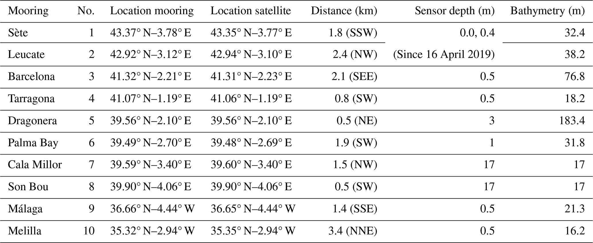
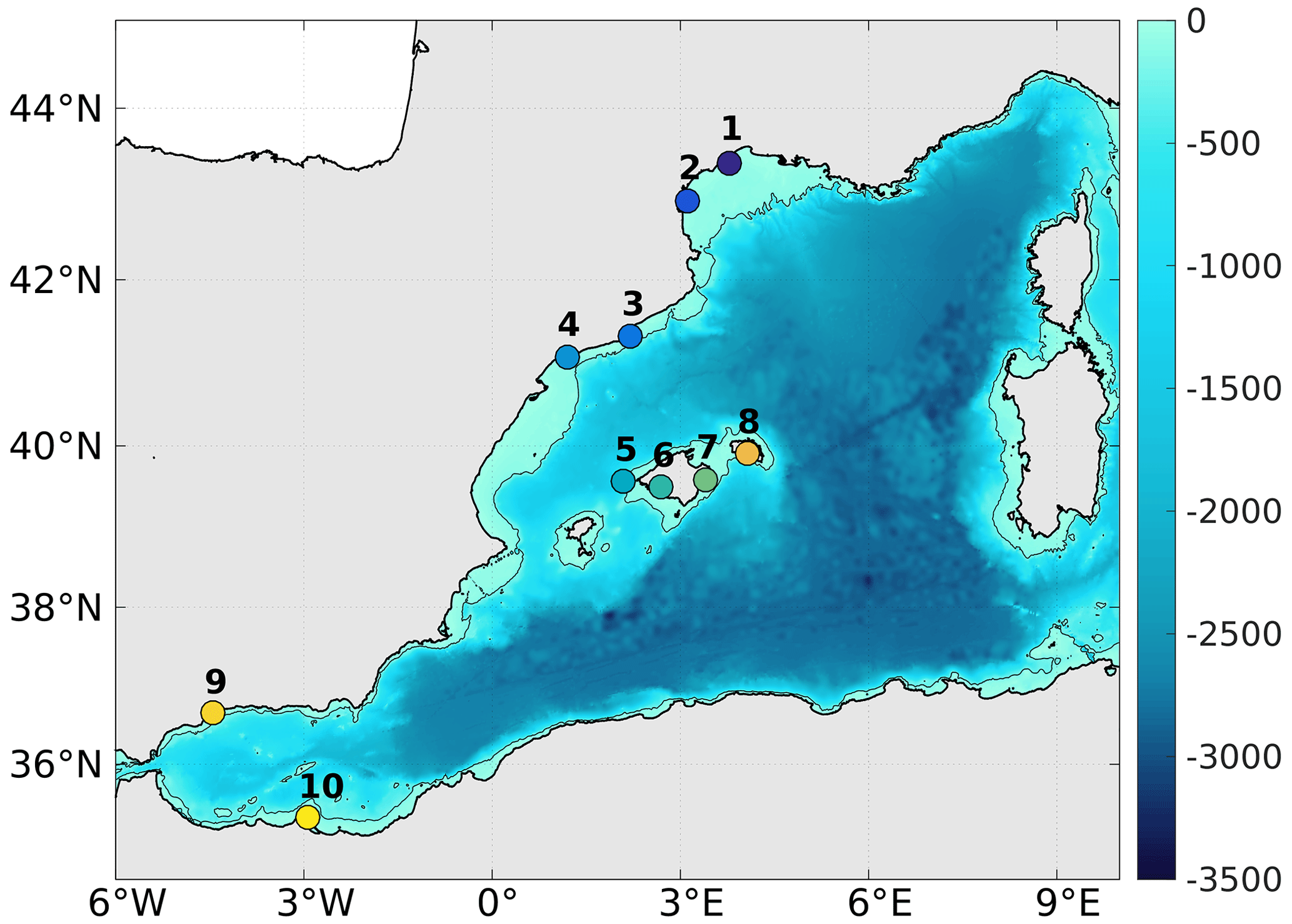
Figure 1Bathymetry (in m) in the western Mediterranean Sea, with the contour at 200 m (grey line) and locations of selected mooring for the study (coloured points), as listed in Table 2.
2.2 Methodology
The commonly used methodology for MHW identification and characterisation from Hobday et al. (2016) is applied. MHWs correspond to daily SSTs exceeding the daily 90th percentile of the local SST distribution over a long-term reference period during at least 5 consecutive days. In addition, two successive MHW events with 2 consecutive days or shorter time break are considered to be a continuous event. This also allows discarding the unrealistic jumps in the SST time series due to sparse erroneous daily interpolated data in the NRT satellite product or in temperature time series from in situ measurements. Finally, the daily climatological mean and threshold time series are smoothed using a 30 d moving window to extract useful climatology from inherently variable data.
First, daily SST from satellites are used to compute climatology over the period 1982–2015 and to detect MHWs from 1982 to 2022, providing valuable information about the 2022 thermal situation over the whole Mediterranean. The chosen reference period starts as early as possible, covers at least a 30-year period as recommended (Hobday et al., 2016), and is aligned with the methodology applied in recent publications in the Mediterranean Sea (Juza and Tintoré, 2021a; Juza et al., 2022). Then, the computation and detection are applied to the daily mean temperature time series from mooring and the nearest satellite point when in situ data are available over the commonly available period 2013–2022 for their direct comparison. Although the in situ time series are shorter than the recommended 30-year minimum for the calculation of climatology and characterisation of MHWs, the calculation of MHWs using their own climatology allows quantifying the amount they differ from their localities (Schlegel et al., 2017b; Juza et al., 2022).
MHW indices are then calculated to characterise the 2022 MHW event and to estimate changes over the last decade. For each year, the MHW mean and maximum intensities above the mean climatology, mean duration, and number of discrete events are computed. MHW cumulative intensity and total days are also provided as interesting indicators for ecosystem stressor, although they are an aggregation of MHW intensity and duration and of duration and frequency, respectively. Finally, ocean temperatures exceeding 28 °C are also identified during the detected MHW events. The combination of abnormal conditions (MHW) and stressful threshold (temperature ranges) allows identifying high thermal stress situations that strongly impact marine ecosystems. In this respect, these extreme temperatures are also investigated through the use and analysis of hourly data, as observed by the moorings.
MHWs are firstly detected using satellite SST with respect to the reference period 1982–2015. MHW characteristics are quantitatively sensitive to the baseline period but remain qualitatively consistent (Dayan et al., 2023). All MHW characteristics have been substantially increasing in the Mediterranean Sea over the last few decades, as studied over 1982–2020 (Juza et al., 2022), 1987–2019 (Dayan et al., 2023), and 1982–2021 (Pastor and Khodayar, 2023). Over the recent period 1982–2022, the local trend estimates with 95 % confidence for the MHW characteristics have reached maximum values of MHW mean and maximum intensities, mean duration, frequency, and total days of 0.18 and 0.65 °C per decade, 12.4 d per decade, 2.4 events per decade, and 42.2 d per decade, respectively (Juza and Tintoré, 2021b; Vargas-Yáñez et al., 2023). In 2022, annual mean and maximum intensities, mean duration, frequency, and total days in the whole Mediterranean oscillate locally over 0.95–3.10 and 1.24–6.47 °C, 5–235 d, 1–15 events, and 5–291 d, respectively (Fig. 2a for MHW total days). In 2022, there are strong differences in MHW characteristics between the western and eastern sub-basins. In the WMed, unprecedented MHWs occurred in 2022, which was the year with the highest annual total days of MHWs over the period 1982–2022, reaching up to 291 d locally along the Spanish coast in the Balearic Sea (Fig. 2a). Spatially integrated in the WMed, annual MHW characteristics reached the highest records ever registered since 1982 during the year 2022 (Fig. 2b for MHW total days). In particular, mean and maximum intensities, mean duration, and total days reached 2.25 and 4.36 °C, 36.6, and 180 d, respectively.

Figure 2(a) MHW total days in 2022 from satellite (product ref. no. 1; Table 1) with respect to the historical data (product ref. no. 2; Table 1) over the period 1982–2015. (b) Time series of annual MHW total days averaged in the western, central, and eastern Mediterranean sub-basins from 1982 to 2022.
MHWs are then detected from daily temperature from mooring and satellite with respect to the reference period 2013–2022, which is the longest common period available in the moorings of study. The use of shorter time series for climatology induces errors in MHW detection and characterisation, in particular due to ocean warming trend (Juza et al., 2022; Izquierdo et al., 2022). More precisely, MHW characteristics detected by satellites at the nearest point from moorings differ according to the reference period used (not shown). Since the SST climatologies have higher values over 2013–2022 than 1982–2015, fewer MHW events are detected using the 2013–2022 reference period. More specifically, annual MHW total days and maximum and cumulative intensities are underestimated by at least 21 %, 5 %, and 29 %, respectively, according to the year and mooring location over 2013–2022, and up to 100 % in some years when MHWs are not detected with the recent and short reference period for climatology (Table 3).
Table 3Underestimation error (in %) of annual MHW characteristics (maximum and cumulative intensities and total days), as detected by the nearest satellite points (product ref. nos. 1 and 2; Table 1) from moorings (product ref. nos. 3, 4, and 5; Table 1) over 2013–2022 with respect to the reference periods 2013–2022 and 1982–2015 (reference for error estimation).

4.1 Results from moorings
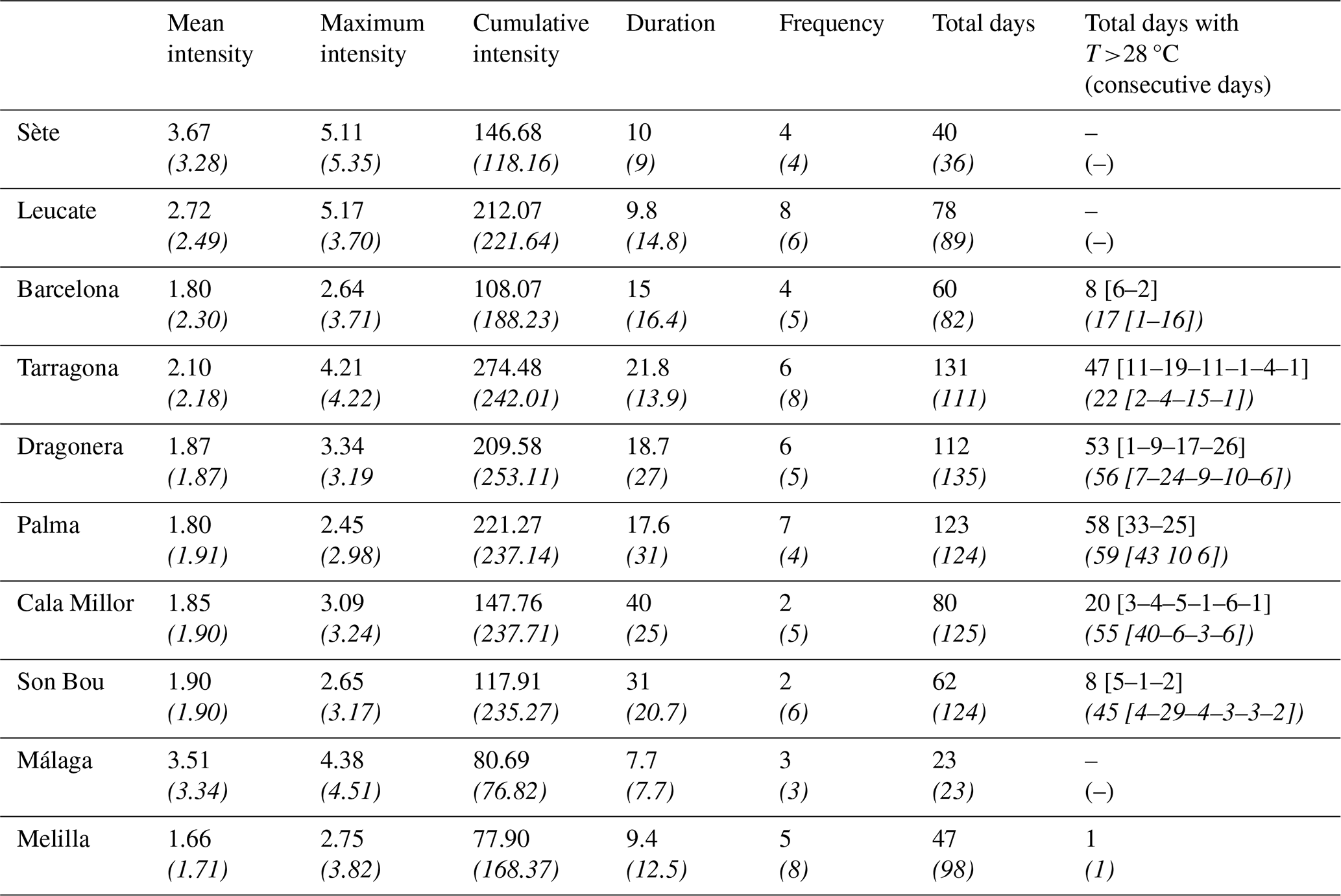
In 2022, all moorings of the coastal WMed detected MHWs (Fig. 3), although MHWs were computed using the reference period 2013–2022. As mentioned above, the use of recent baseline periods underestimates these extreme events (Table 3) due to ocean warming. Different responses are highlighted between the moorings (Fig. 3; Table 4) not only because of the different depths of the sensor installation but also because of their geographical location. Indeed, results from satellite data at the nearest point also indicate the strong spatial variability. In 2022, the highest mean and maximum intensities of MHWs detected by moorings are found along the French coast (Sète and Leucate) and the southern Spanish coast (Málaga) up to 3.67 and 5.17 °C, respectively. The highest mean duration is detected in the nearshore moorings at Cala Millor (40 d) and Son Bou (31 d) installed at 17 m depth, as well as in the coastal Balearic Sea (Tarragona, Dragonera, and Palma), where the highest total days is observed with values up to 131 d at Tarragona in 2022. Such responses have led to highest cumulative intensity and possibly associated thermal stress on ecosystems in the moorings at Palma, Dragonera, Tarragona, Sète, and Leucate. Finally, MHW days with temperature exceeding 28 °C are found in the Balearic Sea, from Barcelona to Cala Millor and Son Bou, with the highest numbers at Tarragona (47), Dragonera (53), and Palma (58). In addition, these highly stressful thermal situations with temperatures higher than 28 °C occurred several times during the summer in 2022, with long periods of consecutive warm days (up to 33 d at Palma). Moorings located along the French coast (Leucate and Sète) and in the Alboran Sea (Málaga and Melilla) did not face daily temperatures warmer than 28 °C.
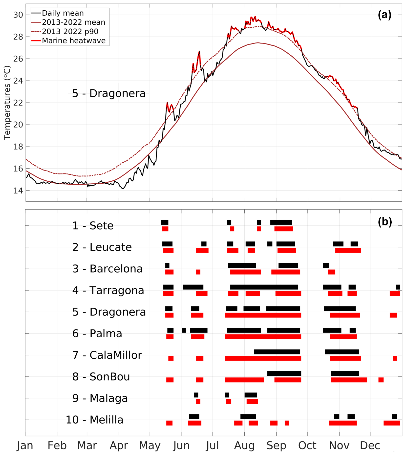
Figure 3(a) Daily SST and MHWs from mooring at Dragonera in 2022 with respect to the reference period 2013–2022 (product ref. no. 3; Table 1). (b) MHW days from study moorings (black) and satellites at the nearest point (red) during the year 2022 (product ref. nos. 3, 4, and 5; Table 1).
Table 4Annual MHW characteristics (mean, maximum, and cumulative intensities, mean duration, frequency, and total days) and number of MHW days with temperatures warmer than 28 °C, as detected by moorings (product ref. nos. 3, 4, and 5; Table 1; top number) and the satellite nearest point (product ref. no. 1; Table 1; bottom number in italics) in 2022.
4.2 Difference between moorings and satellites
Differences between moorings and satellites are found in all locations, although the satellite points are very close to corresponding moorings (Table 4). In 2022, along the French coast, moorings observed higher MHW mean intensity at Sète and Leucate (by 0.39 and 0.23 °C, respectively) and higher MHW maximum intensity at Leucate (by 1.47 °C) than satellites. On the contrary, satellites detected higher MHW mean and maximum intensity at Barcelona than moorings, with differences around 0.5 and 1.07 °C, respectively. Strong differences in MHW maximum intensities are also found at Melilla, Palma, and Son Bou (by 1.13, 0.53, and 0.52 °C, respectively). The MHW mean duration is found to be longer in moorings than satellites, particularly at Cala Millor, Son Bou, and Tarragona (by 15, 10.3, and 7.9 d, respectively), while it is far longer in satellites than in moorings at Dragonera and Palma (by 8.3 and 13.4 d, respectively). The MHW total days and cumulative intensity in 2022 are higher in moorings at Sète and Tarragona than in satellites at the nearest point, while they are found higher in satellites at Leucate, Barcelona, the Balearic Islands stations (particularly at Cala Millor and Son Bou), and Melilla. Finally, where MHW days with temperatures warmer than 28 °C are found (from Barcelona to Son Bou), the number of days is higher in satellites than in moorings, except at Tarragona.
Differences between MHWs detected by satellites and moorings may be explained by several factors, such as the sensor or platform type, spatial and temporal coverage, specific bias at a particular platform, instrumental corrections, validation and calibration, and interpolation methods, as well as the effective depth of measurements (Alvera-Azcárate et al., 2011). While satellites provide SST, the selected moorings collected temperatures at surface or subsurface (from 0.4 to 17 m depths; Table 2). However, even for moorings with sensors installed near the surface (up to 0.5 m), strong differences with satellites are pointed out, as found at Sète, Leucate, and Barcelona for MHW mean and maximum intensities (up to 0.5 and 1.47 °C, respectively) and at Tarragona for MHW mean duration (13.4 d). Also, importantly, results at Cala Millor and Son Bou strongly differ between satellites at the surface and moorings in subsurface (particularly in MHW total days and days with temperatures warmer than 28 °C), as well as between satellite locations and between moorings, highlighting how the coastal ocean response differs from surface to subsurface and from one location to another at both surface and subsurface even in the same sub-region (on each side of the Menorca Channel in the Balearic Islands).
MHWs observed by the moorings are now analysed from 2013 to 2022, and the events in 2022 are compared with those over the last decade (Fig. 4). All years from 2013–2022 suffered from MHWs in several locations of the coastal WMed. In 2020 and 2022, all moorings detected MHWs. While 2020 events mostly happened in winter, 2022 MHWs mainly occurred in summer, reaching high ocean temperatures.
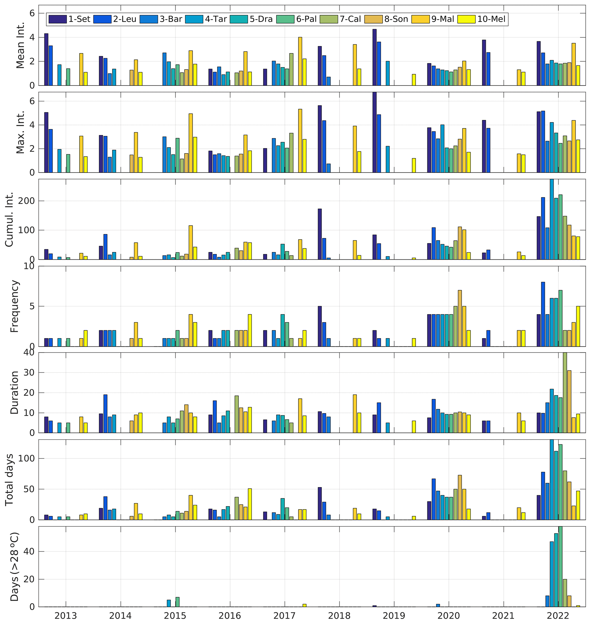
Figure 4Annual MHW characteristics (mean, maximum, and cumulative intensities, mean duration, frequency, and total days) and number of MHW days with temperatures exceeding 28 °C, as detected by moorings (product ref. nos. 3, 4, and 5; Table 1) from 2013 to 2022.
Time series of annual MHW characteristics from moorings show strong spatiotemporal variability. Variations in MHW mean and maximum intensities are highlighted between years, while the increase in MHW frequency and duration in recent years leads to a clear increase in MHW total days and cumulative intensity. In recent years, MHWs did not only occur during their usual season over a longer period but also extended over more seasons. While one season was concerned in 2013 (summer or autumn depending on the mooring), MHW occurrences covered three seasons in 2022 (mainly spring, summer, and autumn) (not shown).
The analysis over the period 2013–2022 highlights that many thermal records were reached in 2022. MHW total days reached the highest number in 2022 for the stations at Leucate, Barcelona, Tarragona, Dragonera, Palma, and Cala Millor; the second highest for Sète, Son Bou, and Melilla; and the fourth highest for Málaga. The MHW cumulative intensity in 2022 is the warmest observed since 2013 for the stations at Leucate, Barcelona, Tarragona, Dragonera, Palma, Cala Millor, and Melilla; the second warmest at Sète and Son Bou; and the third warmest at Málaga. In addition, in 2022, the number of MHW days with temperatures exceeding 28 °C is the highest and can be considered to be a unique year until now for the moorings at Barcelona, Tarragona, Dragonera, Palma, Cala Millor, and Son Bou, although Palma and Tarragona also experienced 7 and 5 d, respectively, with similar warm temperatures in 2015.
Hourly measurements from moorings were averaged on a daily basis to be compared with the daily satellite products. The associated standard deviations over 2013–2022 oscillate between 0.23 and 0.39 °C, depending on the stations. In this section, the temporal resolution impact on the estimation of thermal stress during MHW events is analysed, in particular when high temperatures of 28 °C or more are reached. As highlighted above, the MHW events concerned are those in 2022 at the moorings from Barcelona to Son Bou.
Due to the diurnal cycle, maxima of MHW temperatures are found in the hourly datasets (Fig. 5). While the maxima from the daily datasets vary between 28.37 (Barcelona) and 29.95 °C (Palma), in the hourly datasets they oscillated between 28.96 (Cala Millor) and 31.36 °C (Dragonera), with this latter temperature range being the highest record ever registered by the Spanish mooring network Puertos del Estado. The difference between the daily and hourly data maxima is the highest at Dragonera (1.52 °C) and the smallest at Palma (0.05 °C). The distribution of the temperatures higher than 28 °C is schematically represented by the median, as well as the 5th and 95th percentiles, whose difference allows estimating the width (Fig. 5). This latter value is larger in the hourly than daily datasets due to the diurnal cycle. Comparing the moorings between themselves, the width is larger in both daily and hourly datasets at Dragonera (1.34 and 1.56 °C, respectively), Palma (1.33 and 1.42 °C, respectively), and Tarragona (1.07 and 1.30 °C, respectively), where warmer temperatures were reached.
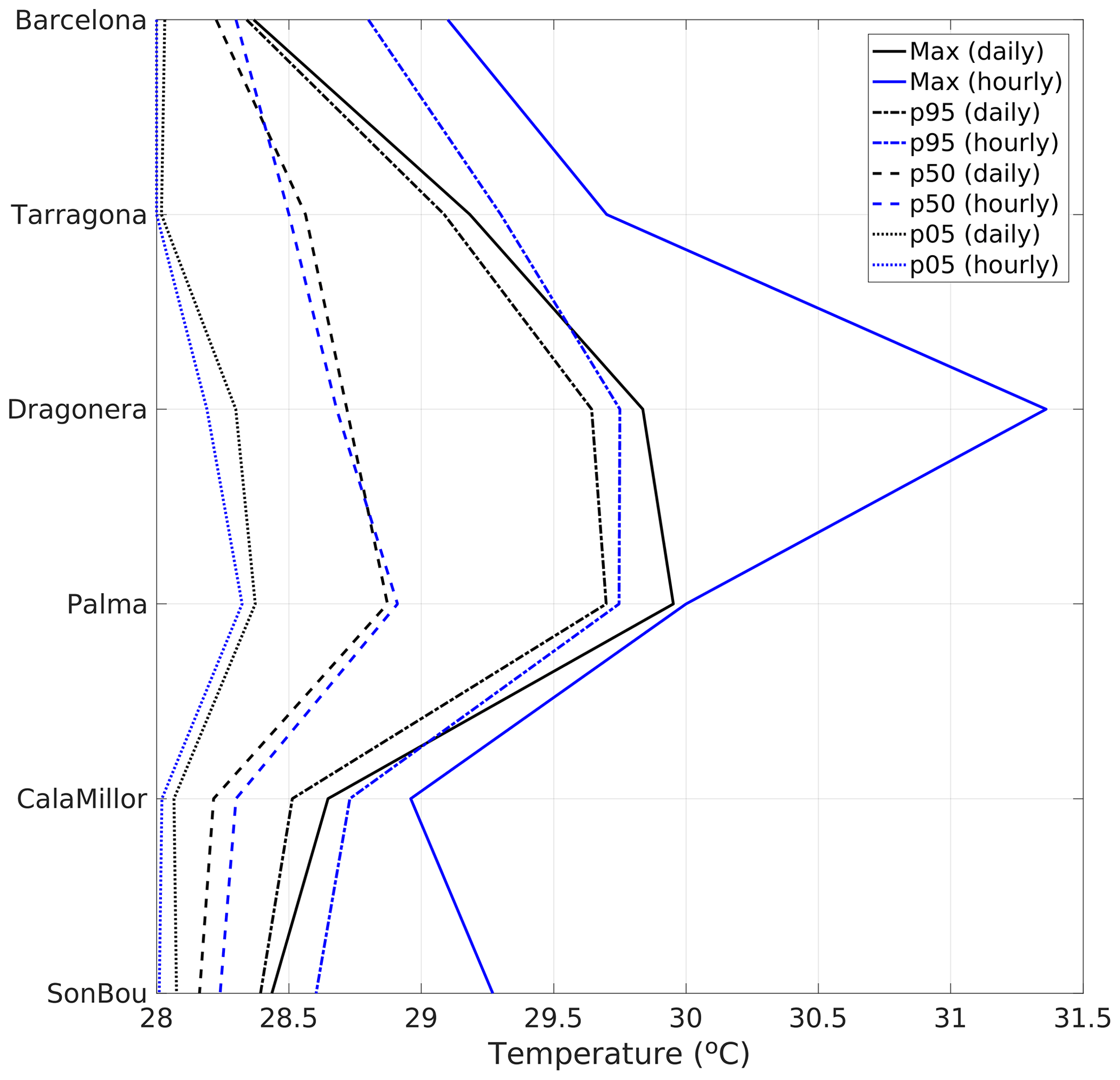
Figure 5The 5th, 50th, and 95th percentiles and maxima of the distribution of MHW temperatures warmer than 28 °C, as detected with the daily (black) and hourly (blue) data from moorings (product ref. nos. 3, 4, and 5; Table 1).
At Palma, the daily and hourly data provide similar results on the maxima reached and distribution characteristics of extreme ocean temperatures in summer. At the moorings located further off the coast of the peninsula (Barcelona, Tarragona, and Dragonera), the temporal resolution of in situ data clearly impacts the extreme temperature observations. Such findings are also highlighted in the two nearshore stations, although their sensors are located at 17 m depth.
Society is facing unprecedented challenges arising from climate change impacts. Among them, marine heatwaves (MHWs) are becoming more frequent, longer, and more intense worldwide (Frölicher et al., 2018; Oliver et al., 2018), particularly in the Mediterranean Sea (Juza et al., 2022; Dayan et al., 2023; Pastor and Khodayar, 2023). Such physical changes have major ecological impacts, with socioeconomic implications and compromising carbon storage, particularly in coastal ocean waters (Smith et al., 2021, 2023). Although MHWs are mainly induced by large-scale anomalous atmospheric conditions in the Mediterranean Sea (Holbrook et al., 2019; Guinaldo et al., 2023; Hamdeno and Alvera-Azcaráte, 2023), the ocean response strongly differs from the open-ocean to nearshore areas and from one coastal location to another (Juza et al., 2022).
In this study, MHWs in the coastal and shallow waters of the western Mediterranean Sea (WMed) have been investigated during the year 2022 and the period 2013–2022. Satellite and moorings observed MHWs along the coast of the WMed, whose characteristics strongly vary in time and space. Coastal MHWs were observed almost every year over the last decade, and they were exceptional in 2022 in intensity, duration, and geographical extension. In 2022, although the coastal MHW events have a strong spatial variation, all moorings – from the northern to the southern WMed and from the surface to the subsurface – observed MHWs registering new records in intensity (in French waters), duration (in subsurface in the Balearic Islands), total days, cumulative intensity (at Tarragona), and number of days with temperatures warmer than 28 °C (at Dragonera and Palma).
Although the satellite products have the great benefit of monitoring all of the ocean surface, differences with the moorings have been detected in the characterisation of MHWs in coastal areas and shallow waters. Compared with mooring measurements at the surface (between 0 and 3 m depth) in 2022, satellites underestimate MHW intensities in French waters and MHW duration at Tarragona, while they overestimate MHW intensities at Barcelona, Palma, and Melilla, as well as MHW duration at Dragonera and Palma. The thermal stress estimation from high-temperature peaks on the physical and biological oceans is also minimised with the use of daily data, which detect underestimated maxima with an up to 1.52 °C difference during the warm events compared to hourly measurements. Finally, the coastal ocean response to extreme warm events strongly differs from the northern to the southern WMed. No coincidence is found between north and south, nor is there a persistent feature in regional differences. Coastal MHWs also vary within the same sub-region (Sète–Leucate, Barcelona–Tarragona, Dragonera–Palma, Cala Millor–Son Bou, and Málaga–Melilla), where extreme events coincide with differences in intensity and duration both at the surface and in subsurface. Such findings assert the importance of multi-platform, multi-sensor, and sustainable ocean observing systems from open-ocean to coastal and nearshore waters and from the surface to the subsurface to continue the investigation concerning MHWs and conduct an impact assessment.
The datasets used in this study can be found in online repositories. The name of the repositories can be found in the article in Table 1.
MJ conducted the study and contributed to the data processing, interpretation of the data, scientific discussion, and writing of the paper. MdA and AFM contributed to the in situ data collection, data processing (quality control), and the revision of the paper.
The contact author has declared that none of the authors has any competing interests.
Publisher’s note: Copernicus Publications remains neutral with regard to jurisdictional claims made in the text, published maps, institutional affiliations, or any other geographical representation in this paper. While Copernicus Publications makes every effort to include appropriate place names, the final responsibility lies with the authors.
We gratefully acknowledge the reviewers and the handling editor for their revision of the article and their comments. The study has been conducted using EU Copernicus Marine Service Information and in situ data which have been collected, processed, and distributed by the Balearic Islands Coastal Observing and Forecasting System (SOCIB).
This paper was edited by Piero Lionello and reviewed by Francisco Pastor, Salvatore Marullo, and one anonymous referee.
Alvera-Azcárate, A., Troupin, C., Barth, A., and Beckers, J. M.: Comparison between satellite and in situ sea surface temperature data in the Western Mediterranean Sea, Ocean Dynam., 61, 767–778, https://doi.org/10.1007/s10236-011-0403-x, 2011.
Bensoussan, N., Chiggiato, J., Buongiorno Nardelli, B., Pisano, A., and Garrabou, J.: Insights on 2017 marine heat waves in the Mediterranean Sea, Copernicus marine service ocean state report: issue 3, J. Oper. Oceanogr., 12, 101–108, https://doi.org/10.1080/1755876X.2019.1633075, 2019.
Buongiorno Nardelli, B., Tronconi, C., Pisano, A., and Santoleri, R.: High and Ultra-High resolution processing of satellite Sea Surface Temperature data over Southern European Seas in the framework of MyOcean project, Remote Sens. Environ., 129, 1–16, https://doi.org/10.1016/j.rse.2012.10.012, 2013.
Cerrano, C., Bavestrello, G., Bianchi, C. N., Cattaneo-Vietti, R., Bava, S., Morganti, C., Morri, C., Picco, P., Sara, G., Schiaparelli, S., Siccardi, A., and Sponga, F.: A catastrophic mass-mortality episode of gorgonians and other organisms in the Ligurian Sea (North-western Mediterranean), summer 1999, Ecol. Lett., 3, 284–293, https://doi.org/10.1046/j.1461-0248.2000.00152.x, 2000.
Coll, M., Piroddi, C., Steenbeek, J., Kaschner, K., Lasram, F. B. R., Aguzzi, J., Ballesteros, E., Bianchi, C. N., Corbera, J., Dailianis, T., Danovaro, R., Estrada, M., Froglia, C., Galil, B. S., Gasol, J. M., Gertwagen, R., Gil, J., Guilhaumon, F., Kesner-Reyes, K., Kitsos, M.-S., Koukouras, A., Lampadariou, N., Laxamana, E., López-Fé de la Cuadra, C. M., Lotze, H. K. Martin, D., Mouillot, D., Oro, D., Raicevich, S., Rius-Barile, J., Saiz-Salinas, J. I., San Vicente, C., Somot, S., Templado, J., Turon, X., Vafidis, D., Villanueva, R., and Voultsiadou, E.: The biodiversity of the Mediterranean Sea: estimates, patterns, and threats, PLoS One, 5, e11842, https://doi.org/10.1371/journal.pone.0011842, 2010.
Dayan, H., McAdam, R., Juza, M., Masina, S., and Speich, S.: Marine heat waves in the Mediterranean Sea: An assessment from the surface to the subsurface to meet national needs, Front. Mar. Sci., 10, 142, https://doi.org/10.3389/fmars.2023.1045138, 2023.
EU Copernicus Marine Service Product: Mediterranean Sea High Resolution and Ultra High-Resolution Sea Surface Temperature Analysis, Mercator Ocean International [data set], https://doi.org/10.48670/moi-00172, 2023a.
EU Copernicus Marine Service Product: Mediterranean Sea – High Resolution L4 Sea Surface Temperature Reprocessed, Mercator Ocean International [data set], https://doi.org/10.48670/moi-00173, 2023b.
EU Copernicus Marine Service Product: Mediterranean Sea – In-Situ Near Real Time Observations, Mercator Ocean International [data set], https://doi.org/10.48670/moi-00044, 2023c.
Fernández-Mora, À., Juza, M., and Tintoré, J.: Hourly in situ data of ocean temperature in the near-shore Balearic Islands over 2012–2020 (Version 1.0.0), Balearic Islands Coastal Observing and Forecasting System (SOCIB) [data set], https://doi.org/10.25704/ra9h-5127, 2021.
Frölicher, T. L., Fischer, E. M., and Gruber, N.: Marine heatwaves under global warming, Nature, 560, 360–364, https://doi.org/10.1038/s41586-018-0383-9, 2018.
Garrabou, J., Coma, R., Bensoussan, N., Bally, M., Chevaldonné, P., Cigliano, M., Diaz, D., Harmelin, J. G., Gambi, M. C., Kersting, D. K., Ledoux, J. B., Lejeusne, C., Linares, C., Marschal, C., Pérez, T., Ribes, M., Romano, J. C., Serrano, E., Teixido, N., Torrents, O., Zabala, M., Zuberer, F., and Cerrano, C.: Mass mortality in North-western Mediterranean rocky benthic communities: effects of the 2003 heat wave, Glob. Change Biol., 15, 1090–1103, https://doi.org/10.1111/j.1365-2486.2008.01823.x, 2009.
Garrabou, J., Gómez-Gras, D., Ledoux, J. B., et al.: Collaborative database to track mass mortality events in the Mediterranean Sea, Front. Mar. Sci., 6, 707, https://doi.org/10.3389/fmars.2019.00707, 2019.
Garrabou, J., Gómez-Gras, D., Medrano, A., et al.: Marine heatwaves drive recurrent mass mortalities in the Mediterranean Sea, Glob. Change Biol., 28, 5708–5725, https://doi.org/10.1111/gcb.16301, 2022.
Giorgi, F.: Climate change hot-spots, Geophys. Res. Lett., 33, L08707, https://doi.org/10.1029/2006GL025734, 2006.
Guerrero-Meseguer, L., Marín, A., and Sanz-Lázaro, C.: Future heat waves due to climate change threaten the survival of Posidonia oceanica seedlings, Environ. Pollut., 230, 40–45, https://doi.org/10.1016/j.envpol.2017.06.039, 2017.
Guinaldo, T., Voldoire, A., Waldman, R., Saux Picart, S., and Roquet, H.: Response of the sea surface temperature to heatwaves during the France 2022 meteorological summer, Ocean Sci., 19, 629–647, https://doi.org/10.5194/os-19-629-2023, 2023.
Hamdeno, M. and Alvera-Azcaráte, A.: Marine heatwaves characteristics in the Mediterranean Sea: Case study the 2019 heatwave events, Front. Mar. Sci., 10, 1093760, https://doi.org/10.3389/fmars.2023.1093760, 2023.
Hobday, A. J., Alexander, L. V. , Perkins, S. E., Smale, D. A., Straub, S. C., Oliver, E. C. J., Benthuysen, J. A., Burrows, M. T., Donat, M. G., Feng, M., Holbrook, N. J., Moore, P. J., Scannell H. A., Sen Gupta, A., and Wernberg, T.: A hierarchical approach to defining marine heatwaves, Prog. Oceanogr., 141, 227–238, https://doi.org/10.1016/j.pocean.2015.12.014, 2016.
Holbrook, N. J., Scannell, H. A., Sen Gupta, A, Benthuysen, J. A., Feng, M., Oliver, E. C. J. Alexander, L. V. Burrows, M. T., Donat, M. G., Hobday, A. J., Moore, P. J., Perkins-Kirkpatrick, S. E., Smale, D. A., Straub, S. C., and Wernberg, T.: A global assessment of marine heatwaves and their drivers, Nat. Commun. 10, 2624, https://doi.org/10.1038/s41467-019-10206-z, 2019.
In Situ TAC partners: EU Copernicus Marine Service Product User Manual for Mediterranean Sea- In-Situ Near Real Time Observations, Issue 2.0, Mercator Ocean International, https://catalogue.marine.copernicus.eu/documents/PUM/CMEMS-INS-PUM-013-030-036.pdf (last access: 22 January 2024), 2023.
Izquierdo P., Taboada F. G., González-Gil R., Arrontes J., and Rico J. M.: Alongshore upwelling modulates the intensity of marine heatwaves in a temperate coastal sea, Sci. Total Environ., 835, 155478, https://doi.org/10.1016/j.scitotenv.2022.155478, 2022.
Juza, M. and Tintoré, J.: Sub-regional Mediterranean Sea Indicators, Balearic Islands Coastal Observing and Forecasting System (SOCIB) [web app], https://apps.socib.es/subregmed-indicators (last access: 1 June 2023), 2020.
Juza, M. and Tintoré, J.: Multivariate Sub-regional ocean indicators in the Mediterranean Sea: From event detection to climate change estimations, Front. Mar. Sci., 8, 610589, https://doi.org/10.3389/fmars.2021.610589, 2021a.
Juza, M. and Tintoré, J.: Sub-regional Mediterranean Marine Heat Waves, Balearic Islands Coastal Observing and Forecasting System (SOCIB) [web app], https://apps.socib.es/subregmed-marine-heatwaves (last access: 1 June 2023), 2021b.
Juza, M., Fernández-Mora, A., and Tintoré, J.: Sub-regional marine heat waves in the Mediterranean Sea from observations: long-term surface changes, sub-surface and coastal responses, Front. Mar. Sci., 9, 785771, https://doi.org/10.3389/fmars.2022.785771, 2022.
Lionello, P. and Scarascia, L.: The relation between climate change in the Mediterranean region and global warming, Reg. Environ. Change, 18, 1481–1493, https://doi.org/10.1007/s10113-018-1290-1, 2018.
Marullo, S., Serva, F., Iacono, R., Napolitano, E., di Sarra, A., Meloni, D., Monteleone, F., Sferlazzo, D., De Silvestri, L., de Toma, V., Pisano, A,, Bellacicco, M., Landolfi, A., Organelli, E., Yang, C., and Santoleri, R.: Record-breaking persistence of the 2022/23 marine heatwave in the Mediterranean Sea, Environ. Res. Lett., 18 114041, https://doi.org/10.1088/1748-9326/ad02ae, 2023.
Oliver, E. C., Donat, M. G., Burrows, M. T., Moore, P. J., Smale, D. A., Alexander, L. V., Benthuysen, J. A., Feng, M., Sen Gupta, A., Hobday, A. J., Holbrook, N. J., Perkins-Kirkpatrick, S. E., Scannell, H. A., Straub, S. C., and Wernberg, T.: Longer and more frequent marine heatwaves over the past century, Nat. Commun., 9, 1324, https://doi.org/10.1038/s41467-018-03732-9, 2018.
Pastor, F. and Khodayar, S.: Marine heat waves: Characterizing a major climate impact in the Mediterranean, Sci. Total Environ., 861, 160621, https://doi.org/10.1016/j.scitotenv.2022.160621, 2023.
Pisano, A., Buongiorno Nardelli B., Tronconi, C., and Santoleri, R.: The new Mediterranean optimally interpolated pathfinder AVHRR SST Dataset (1982–2012), Remote Sens. Environ., 176, 107–116, https://doi.org/10.1016/j.rse.2016.01.019, 2016.
Pisano, A., Marullo, S., Artale, V., Falcini, F., Yang, C., Leonelli, F. E., Santoleri, R., and Nardelli, B. B.: New evidence of Mediterranean climate change and variability from sea surface temperature observations, Remote Sens., 12, 132, https://doi.org/10.3390/rs12010132, 2020.
Pisano, A., Fanelli, C., Tronconi, C., La Padula, F., Cesarini, C., Buongiorno Nardelli, B.: EU Copernicus Marine Service Quality Information Document for Mediterranean Sea High Resolution and Ultra High Resolution Sea Surface Temperature Analysis, Issue 4.0, Mercator Ocean International, https://catalogue.marine.copernicus.eu/documents/QUID/CMEMS-SST-QUID-010-004-006-012-013.pdf (last access: 22 January 2024), 2023a.
Pisano, A., Fanelli, C., Buongiorno Nardelli, B., Tronconi, C., Cesarini, C., and La Padula, F.: EU Copernicus Marine Service Product User Manual for Mediterranean Sea High Resolution and Ultra High Resolution Sea Surface Temperature Analysis, Issue 4.0, Mercator Ocean International, https://catalogue.marine.copernicus.eu/documents/PUM/CMEMS-SST-PUM-010-004-006-012-013.pdf (last access: 22 January 2024), 2023b.
Pisano, A., Fanelli, C., Tronconi, C., Cesarini, C., La Padula, F., and Buongiorno Nardelli, B.: EU Copernicus Marine Service Quality Information Document for Mediterranean Sea – High Resolution L4 Sea Surface Temperature Reprocessed, Issue 3.0, Mercator Ocean International, https://catalogue.marine.copernicus.eu/documents/QUID/CMEMS-SST-QUID-010-021-022-041-042.pdf (last access: 22 January 2024), 2023c.
Pisano, A., Fanelli, C., Tronconi, C., Cesarini, C., La Padula, F., and Buongiorno Nardelli, B.: EU Copernicus Marine Service Product User Manual for Mediterranean Sea – High Resolution L4 Sea Surface Temperature Reprocessed, Issue 3.0, Mercator Ocean International, https://catalogue.marine.copernicus.eu/documents/PUM/CMEMS-SST-PUM-010-021-022-041-042.pdf (last access: 22 January 2024), 2023d.
Schlegel, R. W., Oliver, E. C., Perkins-Kirkpatrick, S., Kruger, A., and Smit, A. J.: Predominant atmospheric and oceanic patterns during coastal marine heatwaves, Front. Mar. Sci., 4, 323, https://doi.org/10.3389/fmars.2017.00323, 2017a.
Schlegel, R. W., Oliver, E., Wernberg, T., and Smit, A. J.: Nearshore and offshore co-occurrence of marine heatwaves and cold-spells, Prog. Oceanogr. 151, 189–205, https://doi.org/10.1016/j.pocean.2017.01.004, 2017b.
Smith, K. E., Burrows, M. T., Hobday, A. J., Sen Gupta, A., Moore, P. J., Thomsen, M., Wernberg, T., and Smale, D. A.: Socioeconomic impacts of marine heatwaves: Global issues and opportunities, Science, 374, 6566, https://doi.org/10.1126/science.abj3593, 2021.
Smith, K. E., Burrows, M. T., Hobday, A. J., King, N. G., Moore, P. J., Sen Gupta, A., Thomsen, M. S., Wernberg, T., and Smale, D. A.: Biological impacts of marine heatwaves, Annu. Rev. Mar. Sci., 15, 119–145, https://doi.org/10.1146/annurev-marine-032122-121437, 2023.
Tintoré, J. and Casa Pérez, B.: Buoy BahiaDePalma data (Version 1.0.0), Balearic Islands Coastal Observing and Forecasting System (SOCIB) [data set], https://doi.org/10.25704/S6JB-CK61, 2022.
Vargas-Yáñez, M., Moya, F., Serra, M., Juza, M., Jordà, G., Ballesteros, E., Alonso, C., Pascual, J., Salat, J., Moltó, V., Tel, E., Balbín, R. Santiago, R., Piñeiro, S., and García-Martínez, M. C.: Observations in the Spanish Mediterranean waters: A review and update of results from 30-year monitoring, J. Mar. Sci. Eng., 11, 1284, https://doi.org/10.3390/jmse11071284, 2023.
Verdura, J., Santamaría, J., Ballesteros, E., Smale, D. A., Cefalì, M. E., Golo, R., and Cebrian, E.: Biodiversity loss in a Mediterranean ecosystem due to an extreme warming event unveils the role of an engineering gorgonian species, Sci. Rep., 9, 5911, https://doi.org/10.1038/s41598-019-41929-0, 2019.
Verdura, J., Santamaría, J., Ballesteros, E., Smale, D. A., Cefalì, M. E., Golo, R., de Caralt, S., Vergés, A., and Cebrian, E.: Local-scale climatic refugia offer sanctuary for a habitat-forming species during a marine heatwave, J. Ecol., 109, 1758–1773, https://doi.org/10.1111/1365-2745.13599, 2021.
United Nations Environment Programme/Mediterranean Action Plan and Plan Bleu: State of the Environment and Development in the Mediterranean, Nairobi, https://planbleu.org/wp-content/uploads/2021/04/SoED_full-report.pdf (last access: 1 June 2023), 2020.
Wehde, H., von Schuckmann, K., Pouliquen, S., Grouazel, A., Bartolome, T., Tintoré, J., De Alfonso Alonso-Munoyerro, M., Carval, T., Racapé V., and the INSTAC team: EU Copernicus Marine Service Quality Information Document for Mediterranean Sea- In-Situ Near Real Time Observations, INSITU_MED_PHYBGCWAV_DISCRETE_MYNRT_013_035, Issue 2.3, Mercator Ocean International, https://catalogue.marine.copernicus.eu/documents/QUID/CMEMS-INS-QUID-013-030-036.pdf (last access: 22 January 2024), 2023.